 Block
From the record
3 National Register listings published here.
Sources: the National Register database, National Park Service
24 topographic sheets cover 5 settlements here, and 3 properties are on the National Register of Historic Places.
3 National Register listings published here.
Sources: the National Register database, National Park Service
Every property in this county listed on the National Register of Historic Places, with the year it was listed and the federal nomination document.
| Photograph | Property | Type | Listed | Reference |
|---|---|---|---|---|
 | Alliance Commercial Historic District | district | 2007 | 07000180 |
 | Box Butte County Courthouse | district | 1990 | 89002212 |
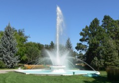 | City of Alliance Central Park Fountain | object | 1990 | 90001772 |
Every wildfire the federal occurrence database records inside this county: 203 of them, burning about 2,516 acres. 44 started naturally and none was recorded as arson. Each settlement page carries the fires within five miles of it.
| Reported cause | Fires |
|---|---|
| Missing data/not specified/undetermined | 50 |
| Natural | 44 |
| Equipment and vehicle use | 31 |
| Debris and open burning | 24 |
| Railroad operations and maintenance | 20 |
| Fireworks | 20 |
| Power generation/transmission/distribution | 8 |
| Recreation and ceremony | 5 |
| Misuse of fire by a minor | 1 |
The five largest, by the area the report gives. None of them was recorded as arson.
| Date | Cause | Size | Reported by | Name on the report |
|---|---|---|---|---|
| 25 June 2007 | Natural | 800 acres | Nebraska Forest Service | not named |
| 4 July 2020 | Missing data/not specified/undetermined | 300 acres | Nebraska Forest Service | not named |
| 11 July 2016 | Railroad operations and maintenance | 200 acres | Nebraska Forest Service | not named |
| 12 July 2016 | Equipment and vehicle use | 200 acres | Nebraska Forest Service | not named |
| 27 July 2014 | Debris and open burning | 150 acres | Nebraska Forest Service | not named |
| 20 July 2016 | Equipment and vehicle use | 110 acres | Nebraska Forest Service | not named |
| 21 July 2017 | Equipment and vehicle use | 90 acres | Nebraska Forest Service | not named |
| 3 August 2020 | Equipment and vehicle use | 85 acres | Nebraska Forest Service | not named |
Every settlement page carries the fires within five miles of it - see the settlement index below.
The NOAA Storm Events Database holds 538 reports for this county, causing no deaths, 1 injury and about $4,693,430 in recorded property damage. Each settlement page carries the reports that name it.
| Kind of event | Reports |
|---|---|
| Hail | 342 |
| Thunderstorm Wind | 126 |
| Tornado | 43 |
| Funnel Cloud | 9 |
| Heavy Rain | 9 |
| Flash Flood | 6 |
| Lightning | 2 |
| Winter Weather | 1 |
The most serious of them, by death, then injury, then recorded damage. The accounts are quoted exactly as the forecast office filed them.
| When | Event | Place named | Harm | What the report says |
|---|---|---|---|---|
| December 1997 | Winter Weather | Countywide | 1 hurt, $5,000 | no account filed |
| June 1991 | Tornado (F1) | not stated | $2,500,000 | no account filed |
| June 2017 | Tornado (EF0) | Letan | $1,000,000 | A discontinuous tornado path continued northeast into Box Butte County from Morrill County. Additional roof damage was surveyed to a large building near the Alliance Airport (DI 1, DOD 3). This was the end of the discontinuous tornado path in Morrill and Box Butte Counties. Sixty-five train cars were blown over south of Alliance. |
| May 2006 | Thunderstorm Wind | Hemingford | $250,000 | Estimated wind gusts of 60 mph and some nickel size hail reported from Hemingford, Nebraska, withan unofficial wind gust of 96 mph at a highway observation platform 5 miles east of Hemingford. Center pivots flipped and about 45 power poles damaged. |
| June 1975 | Tornado (F2) | not stated | $250,000 | no account filed |
| June 1996 | Hail | Alliance | $200,000 | no account filed |
| May 2010 | Thunderstorm Wind | Alliance | $50,000 | Farm received strong to severe winds for an hour causing structural damage. |
| July 1997 | Thunderstorm Wind | Alliance | $50,000 | Roofs torn off 1 mobile home and 1 apartment complex; at least 2 cars damaged by fallen limbs; power lines downed; 1 camper flipped; trees uprooted; 3' diameter maple tree thrown onto roof of house; 6' wooden fence downed. |
| May 2010 | Thunderstorm Wind | Alliance | $40,000 | Power poles down in western part of town. General Manager of PREMA said the storm took out roughly 40 electrical poles around the area. The downed poles caused roughly 1,000 PREMA electrical services to be stopped across the county. |
| August 2004 | Hail | Alliance | $40,000 | no account filed |
| July 2000 | Hail | Alliance | $30,000 | no account filed |
| August 2001 | Hail | Alliance | $25,000 | 1.75 inch hail fell over the southwest side of Alliance, NE. |
| May 1988 | Tornado (F1) | not stated | $25,000 | no account filed |
| June 1975 | Tornado (F1) | not stated | $25,000 | no account filed |
| July 1964 | Tornado (F1) | not stated | $25,000 | no account filed |
| May 1962 | Tornado (F2) | not stated | $25,000 | no account filed |
| June 1958 | Tornado | not stated | $25,000 | no account filed |
| May 1998 | Thunderstorm Wind | Alliance | $20,000 | A thunderstorm produced a microburst in Alliance which uprooted trees at a residence home and the owners vehicle was damaged by falling trees. Damage to power poles also occurred in Alliance. |
| March 1998 | Lightning | Alliance | $12,000 | A bolt of lightning hit a tree around which a porch of a house was built. All of the windows in the porch were shattered. The bolt also damaged the adjoining kitchen, bathroom and an antique collection. The homeowners stated that the biggest loss was all of thier antiques. |
| August 2004 | Hail | Alliance | $10,000 | 2 inch diamter hail broke windows from 3 to 7 miles northeast of Alliance, Ne. |
| September 1999 | Hail | Berea | $10,000 | 1.75 inch hail damaged house and broke windows 3 miles east of Berea, NE |
| June 1997 | Hail | Alliance | $10,000 | no account filed |
| May 1998 | Lightning | Alliance | $5,000 | Lightning caused two power outages and transformer failures in Alliance. |
| June 1998 | Thunderstorm Wind | Alliance | $5,000 | Strong thunderstorm winds up to 62 mph knocked down 2 power poles 8 miles south-southwest of Alliance. The poles were broke off at ground level and caused a brief power outage for customers in the immediate area. |
| July 1995 | Hail | not stated | $5,000 | Up to one and three-quarter diameter hail fell in a 16 mile long path from one mile northwest of Box Butte Reservoir to 5 miles east of Alliance. The width of the hail swath was four to five miles wide. The hail severely damaged 11,000 acres of crops in the hail swath. In addition, some vehicles and buildings were damaged. |
| May 1993 | Tornado (F1) | Hemingford | $5,000 | A tornado was on the ground for about 30 seconds 3.5 miles east of Hemingford on Highway 87. The tornado destroyed a 1500 bushel grain bin and moved some farm machinery. |
| June 1997 | Hail | Hemingford | $5,000 | no account filed |
| June 1997 | Hail | Hemingford | $5,000 | no account filed |
| June 1997 | Hail | Berea | $5,000 | no account filed |
| June 1997 | Hail | Hemingford | $5,000 | no account filed |
| May 2010 | Thunderstorm Wind | Alliance | $4,000 | Tin blown off roof of garage. |
| June 2001 | Thunderstorm Wind | Alliance | $4,000 | Estimated wind gusts around 60 mph. Unconfirmed tornado uprooted trees andremoved a well-house roof. Storage shed also destroyed. |
| May 2010 | Thunderstorm Wind | Alliance | $3,000 | A 100 year old cottonwood tree fell in Central Park. |
| July 1990 | Tornado (F0) | not stated | $2,500 | no account filed |
| June 1989 | Tornado (F1) | not stated | $2,500 | no account filed |
| May 1977 | Tornado | not stated | $2,500 | no account filed |
| July 1955 | Tornado (F0) | not stated | $2,500 | no account filed |
| June 1997 | Hail | Hemingford | $2,000 | Window knocked out of car. |
| May 2010 | Thunderstorm Wind | Alliance | $1,100 | Shingles blown off of house and 6 to 8 inch tree limbs down. |
| August 1996 | Hail | Berea | $1,000 | no account filed |
| May 2010 | Hail | Berea | $700 | Four to six inch diameter limbs down. |
| June 1989 | Tornado (F0) | not stated | $250 | no account filed |
| August 1955 | Tornado (F1) | not stated | $250 | no account filed |
| August 1996 | Thunderstorm Wind | Hemingford | $100 | no account filed |
| June 1958 | Tornado | not stated | $30 | no account filed |
| May 2025 | Hail | Hemingford | - | Facebook post and video of ping pong ball sized hail. |
| May 2025 | Hail | Hemingford | - | Trained spotter reports 1.75in hail. |
| May 2025 | Hail | Hemingford | - | Facebook report with photo of quarter to half dollar sized hail. |
| August 2025 | Thunderstorm Wind | (Aia)Alliance Arpt | - | Isolated thunderstorm gust at the Alliance Airport to 63 mph. |
| July 2025 | Hail | Letan | - | Report from mPING of quarter size hail. |
| July 2025 | Hail | Birdsell | - | Golf ball to baseball size hail broke several windows. Time estimated from radar. |
| July 2025 | Hail | (Aia)Alliance Arpt | - | Report from mPING of half dollar size hail. |
| July 2025 | Hail | (Aia)Alliance Arpt | - | Report from mPING of ping pong ball size hail. |
| June 2025 | Hail | Alliance | - | Mainly dime to nickel size hail with a few quarters reported northeast of Alliance Nebraska. |
| July 2024 | Thunderstorm Wind | (Aia)Alliance Arpt | - | Alliance Airport ASOS station (KAIA) measured wind gust. |
| July 2024 | Thunderstorm Wind | Nonpareil | - | Received social media report estimating 70 mph wind gusts with up to nickel size hail covering the ground. |
| June 2024 | Hail | Hemingford | - | A storm chaser reported hail dollar sized hail 1 mile E of Hemingford. |
| June 2024 | Hail | Hemingford | - | The public reported nickel to quarter sized hail in the town of Hemingford. |
| June 2024 | Hail | Alliance | - | A trained weather spotter reported nickel sized hail 5 miles W of Alliance. |
| June 2024 | Hail | Berea | - | A trained weather spotter reported quarter sized hail 15 miles NE of Berea. |
Named settlements recorded in the Geographic Names Information System, each with the topographic sheets covering it. Villages, hamlets and abandoned places alike. Each is shown with the nearest named watercourse or landform and the survey quadrangle it falls on.