 Block
From the record
1 National Register listing published here.
Sources: the National Register database, National Park Service
31 topographic sheets cover 8 settlements here, and 1 property is on the National Register of Historic Places.
1 National Register listing published here.
Sources: the National Register database, National Park Service
Every property in this county listed on the National Register of Historic Places, with the year it was listed and the federal nomination document.
| Photograph | Property | Type | Listed | Reference |
|---|---|---|---|---|
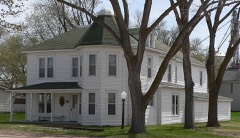 | Miller Hotel | building | 1989 | 89002041 |
Every wildfire the federal occurrence database records inside this county: 101 of them, burning about 71,184 acres. 29 started naturally and none was recorded as arson. Each settlement page carries the fires within five miles of it.
| Reported cause | Fires |
|---|---|
| Natural | 29 |
| Equipment and vehicle use | 26 |
| Debris and open burning | 23 |
| Missing data/not specified/undetermined | 14 |
| Power generation/transmission/distribution | 6 |
| Fireworks | 2 |
| Misuse of fire by a minor | 1 |
The five largest, by the area the report gives. None of them was recorded as arson.
| Date | Cause | Size | Reported by | Name on the report |
|---|---|---|---|---|
| 20 July 2012 | Natural | 66,745 acres | Nebraska Forest Service | FAIRFIELD CREEK |
| 26 March 2012 | Natural | 1,005 acres | Nebraska Forest Service | not named |
| 22 August 2012 | Equipment and vehicle use | 800 acres | Nebraska Forest Service | not named |
| 25 February 2012 | Equipment and vehicle use | 500 acres | Nebraska Forest Service | not named |
| 4 March 2016 | Power generation/transmission/distribution | 300 acres | Nebraska Forest Service | not named |
| 19 July 2012 | Natural | 250 acres | Nebraska Forest Service | not named |
| 29 March 2009 | Debris and open burning | 180 acres | Nebraska Forest Service | not named |
| 21 January 2014 | Equipment and vehicle use | 150 acres | Nebraska Forest Service | not named |
Every settlement page carries the fires within five miles of it - see the settlement index below.
The NOAA Storm Events Database holds 458 reports for this county, causing no deaths, 1 injury and about $10,059,280 in recorded property damage. Each settlement page carries the reports that name it.
| Kind of event | Reports |
|---|---|
| Hail | 284 |
| Thunderstorm Wind | 117 |
| Tornado | 38 |
| Flash Flood | 9 |
| Funnel Cloud | 4 |
| Flood | 3 |
| Heavy Rain | 2 |
| Lightning | 1 |
The most serious of them, by death, then injury, then recorded damage. The accounts are quoted exactly as the forecast office filed them.
| When | Event | Place named | Harm | What the report says |
|---|---|---|---|---|
| July 1979 | Tornado (F2) | not stated | 1 hurt, $2,500,000 | no account filed |
| June 1997 | Hail | Johnstown | $1,200,000 | Scattered supercells with winds in excess of 60 mph moved southeast across North Central Nebraska . The severe thunderstorms produced large hail which severely damaged crops and property. |
| July 2025 | Thunderstorm Wind | Ainsworth | $1,000,000 | Severe thunderstorms producing several wet microbursts, led to violent winds in Ainsworth. Wind gusts, estimated at around 100 MPH, uprooted several mature trees in and around Ainsworth. Other mature trees were snapped above ground level. Numerous reports of power lines down, one of which, led to fire at a residence on the north side of Ainsworth. One house sustained significant damage as a mature tree impacted the roof of this residence. |
| August 2010 | Thunderstorm Wind | Ainsworth | $800,000 | A storm hit Ainsworth with damage significant that included the destruction of two buildings and many trees. Power lines were also downed by the winds and resulted in a power outage that lasted about two hours. The damage was most severe in a relatively concentrated zone, on the north side of the town, which is consistent with a microburst damage path. It was in that area where one of the buildings was destroyed. Debris from the steel building was scattered to the north up to 200 yards, and steel was twisted violently around trees north of the building site. |
| June 1997 | Hail | Ainsworth | $600,000 | no account filed |
| July 2013 | Thunderstorm Wind | Ainsworth | $500,000 | Strong wind gusts estimated to 80 MPH destroyed a machine shed, cattle feeding shed, and hog shed 3 miles west of Ainsworth. A dry fertilizer plant also sustained heavy damage 2 miles west of Ainsworth. Three miles southwest of Ainsworth, a barn sustained heavy damage. |
| July 2013 | Thunderstorm Wind | Ainsworth | $500,000 | Law Enforcement reports numerous trees and power lines down as a result of thunderstorm winds in and around Ainsworth. |
| June 1997 | Flash Flood | Long Pine | $500,000 | Flash flooding washed out a bridge near Long Pine. People were evacuated along Long Pine Creek. |
| June 1999 | Thunderstorm Wind | Ainsworth | $250,000 | A thunderstorm system produced strong wind with speed estimated in excess of 90 mph. The wind storm actually began in eastern Cherry County near Wood Lake and travelled across most of northern Brown County doing major damage to grain bins 10 miles west of Ainsworth. In the city of Ainsworth, numerous trees were broken and roofs were damaged by the wind. A tree fell on a 1998 Ford Pickup smashing the cab. The Pickup was a total loss. |
| July 1987 | Tornado (F1) | not stated | $250,000 | no account filed |
| July 1984 | Tornado (F1) | not stated | $250,000 | no account filed |
| July 1971 | Tornado (F0) | not stated | $250,000 | no account filed |
| July 1971 | Tornado (F1) | not stated | $250,000 | no account filed |
| September 2019 | Flash Flood | Long Pine | $150,000 | Bridge over Long Pine Creek washed out. |
| July 2009 | Thunderstorm Wind | Ainsworth | $120,000 | Several center pivot irrigation systems were overturned by the strong winds. In addition, a few rafters and garage walls were blown down at the construction site of a home being built. |
| June 2008 | Hail | Ainsworth | $100,000 | The large hail damaged roofs, tore holes in the siding of homes, and damaged vehicles. Hail and heavy rain caused street flooding when storm drains become plugged. Waves created by passing motorists caused water to flow into basements. |
| June 2010 | Flood | Johnstown | $75,000 | Thunderstorms with prolonged heavy rain caused widespread flooding across southern Brown County. The Calamus River undercut the Elsmere Road and numerous other rural roads were severely damaged from flooding. |
| July 2000 | Tornado (F1) | Johnstown | $75,000 | no account filed |
| July 2025 | Thunderstorm Wind | Ainsworth | $50,000 | Wet microbursts with wind speeds estimated up to 95 MPH, led to severe tree damage along highway 20 from approximately 3 miles east of Ainsworth to just north of Long Pine. There were several cases of mature-soft and hard wood trees heavily damaged along this line. Tree limbs up to 6 inches in diameter were reported along with numerous uprooted trees. |
| August 2010 | Thunderstorm Wind | Ainsworth | $40,000 | Winds destroyed a 90 by 30 building. |
| May 2007 | Tornado (EF1) | Ainsworth | $40,000 | Storm spotters tracked the tornado as it entered Brown County from Blaine County around 33 miles south of Ainsworth. The tornado traveled north about 14 miles before lifting 19 miles south of Ainsworth. The tornado snapped trees and power poles, destroyed outbuildings, tore off part of a house roof and broke windows, moved a pickup truck and horse trailer, and picked up calves. The average path width of the tornado was 220 yards. The total path length was approximately 55 miles. |
| August 2002 | Thunderstorm Wind | Ainsworth | $40,000 | Numerous large tree limbs were down. |
| July 2007 | Thunderstorm Wind | Ainsworth | $30,000 | Thunderstorm outflow winds broke off a couple of large trees, took down power lines, overturned a beer truck on Highway 20 west of Ainsworth, and pushed over large storage tanks at the agricultural co-operative business in Ainsworth. |
| June 2008 | Hail | Ainsworth | $25,000 | The large hail tore holes in the siding of a home and severely damaged a couple of vehicles. |
| July 2000 | Hail | Johnstown | $25,000 | no account filed |
| June 1992 | Tornado (F1) | not stated | $25,000 | no account filed |
| June 2024 | Flash Flood | Long Pine | $20,000 | Emergency management reports washed out roads along Hidden Paradise Area on the southwest side of Long Pine. There was a mudslide along a hillside in the Hidden Paradise Area which knocked down a tree and led to a washout on Paradise road. Long Pine Creek was reported at bank full and Richardson road south of Long Pine was washed out. Water was reported over South Pine road on the east side of Long Pine. |
| April 2023 | Thunderstorm Wind | Long Pine | $20,000 | Thunderstorm wind gusts, estimated at 60 MPH, damaged several calving sheds at this location. |
| August 2001 | Hail | Ainsworth | $20,000 | no account filed |
| August 2001 | Hail | Johnstown | $20,000 | no account filed |
| June 2024 | Tornado (EF1) | Ainsworth | $15,000 | Tornado briefly touched down, rolling and severely damaging a single wide manufactured home. Other outbuildings were destroyed at this location which were significantly aged. Tree limbs were broken and trees snapped. |
| March 2019 | Flood | Long Pine | $15,000 | Flooding reported at the Hidden Paradise Resort along the Long Pine Creek. |
| July 2009 | Hail | Ainsworth | $15,000 | Large hail fell along a one mile stretch of Highway 20. |
| August 2008 | Hail | Johnstown | $15,000 | Golf ball to baseball size hail occurred near Enders Lake. The large hail severely damaged vehicles. |
| June 2008 | Hail | (Anw)Ainsworth Muni | $15,000 | The large hail destroyed corn crops, damaged a garage roof, and broke windows. |
| August 2002 | Hail | Johnstown | $15,000 | Hail of various sizes covered the ground. |
| July 2001 | Thunderstorm Wind | Ainsworth | $15,000 | Strong winds damaged a covered porch and downed several tree limbs. |
| July 1998 | Tornado (F1) | Johnstown | $15,000 | Tornado traveled through open rangeland. damaging several windmills and trees. |
| July 2000 | Hail | Johnstown | $15,000 | no account filed |
| July 2025 | Thunderstorm Wind | (Anw)Ainsworth Muni | $10,000 | Thunderstorm wind gusts, estimated at 80 MPH sheared off multiple tree limbs up to 8 inches in diameter. |
| June 2008 | Tornado (EF0) | Ainsworth | $10,000 | A trained spotter reported the brief touchdown of the tornado. The tornado damaged corrals on a ranch. |
| August 2007 | Thunderstorm Wind | Long Pine | $10,000 | Thunderstorm winds destroyed half a barn, broke off and uprooted trees, and destroyed a small outbuilding. |
| June 2000 | Hail | Johnstown | $10,000 | Hail damage to house siding. |
| June 2000 | Thunderstorm Wind | Ainsworth | $10,000 | Wind damage to house under construction. |
| August 1998 | Hail | Johnstown | $10,000 | Thunderstorm winds downed several large trees. |
| August 1996 | Thunderstorm Wind | Ainsworth | $10,000 | no account filed |
| July 2001 | Hail | Ainsworth | $8,000 | no account filed |
| July 2001 | Hail | Ainsworth | $6,000 | no account filed |
| August 2012 | Hail | Long Pine | $5,000 | Some windows were cracked from golf ball size hail. |
| August 2011 | Thunderstorm Wind | (Anw)Ainsworth Muni | $5,000 | Winds increased above 60 m.p.h. at 8:25 p.m. CDT and stayed above 60 m.p.h. through 9:30 p.m. CDT. The peak gust of 70 m.p.h. occurred at 8:42 p.m. CDT. There was also great amounts of tree damage in the city of Ainsworth from the strong winds. |
| July 2002 | Tornado (F0) | Ainsworth | $5,000 | Irrigation system was damaged as the tornado made a brief touchdown. |
| August 1998 | Thunderstorm Wind | Johnstown | $5,000 | Large tree blown down. |
| September 2008 | Hail | Long Pine | $5,000 | no account filed |
| June 2008 | Hail | Ainsworth | $5,000 | no account filed |
| June 2006 | Hail | Ainsworth | $5,000 | no account filed |
| September 2005 | Hail | Ainsworth | $5,000 | no account filed |
| June 2001 | Hail | Ainsworth | $5,000 | no account filed |
| June 2001 | Hail | Johnstown | $5,000 | no account filed |
| June 1999 | Hail | Ainsworth | $5,000 | no account filed |
| June 1997 | Hail | Ainsworth | $4,000 | Thunderstorm winds blew down large tree limbs. |
The Survey's mineral resources record lists 2 workings inside this county. 1 still produces and 1 is closed or unrecorded. Each settlement page carries the workings within five miles of it.
| Commodity | Workings |
|---|---|
| Sand and Gravel, Construction | 2 |
The least common of them first, because a county's hundredth gravel pit says nothing its first ten did not.
| Where | Site | Commodity | Status | Recorded |
|---|---|---|---|---|
| Costello Pit and Plant | Sand and Gravel, Construction | Past Producer | ||
| Quinn Sand and Gravel | Sand and Gravel, Construction | Producer |
Named settlements recorded in the Geographic Names Information System, each with the topographic sheets covering it. Villages, hamlets and abandoned places alike. Each is shown with the nearest named watercourse or landform and the survey quadrangle it falls on.
North Pine precinct · 69217 · On Bone Creek · Bassett NW quadrangle
10 sheets, 1950 to 1989
No longer a settlement
The vanished settlements of Brown County: the places named above that are no longer on the map.