 Block
From the record
10 National Register listings published here.
Sources: the National Register database, National Park Service
22 topographic sheets cover 13 settlements here, and 10 properties are on the National Register of Historic Places.
10 National Register listings published here.
Sources: the National Register database, National Park Service
Every property in this county listed on the National Register of Historic Places, with the year it was listed and the federal nomination document.
| Photograph | Property | Type | Listed | Reference |
|---|---|---|---|---|
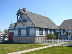 | Christ Episcopal Church | building | 1994 | 94001232 |
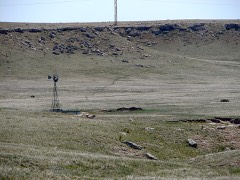 | Deadwood Draw | site | 1992 | 92001574 |
| Fort Sidney Historic District | district | 1973 | 73001056 | |
| Daniel and Sarah Herboldsheimer Ranch | district | 1990 | 90000566 | |
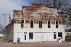 | Lodgepole Opera House | building | 1988 | 88000947 |
 | Sidney Carnegie Library | building | 1991 | 91000838 |
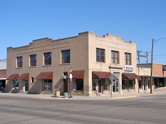 | Sidney Historic Business District | district | 1994 | 94001233 |
| Sidney Historic Business District (Boundary Increase) | district | 2004 | 04001086 | |
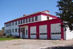 | Sioux Ordnance Depot Fire & Guard Headquarters | building | 1994 | 94001234 |
| Water Holes Ranch | site | 1992 | 92001575 |
Every wildfire the federal occurrence database records inside this county: 247 of them, burning about 6,230 acres. 24 started naturally and 2 were recorded as arson. Each settlement page carries the fires within five miles of it.
| Reported cause | Fires |
|---|---|
| Missing data/not specified/undetermined | 74 |
| Debris and open burning | 48 |
| Equipment and vehicle use | 42 |
| Railroad operations and maintenance | 25 |
| Natural | 24 |
| Power generation/transmission/distribution | 15 |
| Fireworks | 10 |
| Smoking | 5 |
| Misuse of fire by a minor | 2 |
| Arson/incendiarism | 2 |
The five largest, by the area the report gives. None of them was recorded as arson.
| Date | Cause | Size | Reported by | Name on the report |
|---|---|---|---|---|
| 16 June 2012 | Natural | 3,600 acres | Nebraska Forest Service | not named |
| 8 November 2020 | Railroad operations and maintenance | 963 acres | Nebraska Forest Service | not named |
| 29 July 2017 | Equipment and vehicle use | 320 acres | Nebraska Forest Service | not named |
| 31 August 2012 | Smoking | 150 acres | Nebraska Forest Service | not named |
| 26 June 2012 | Debris and open burning | 100 acres | Nebraska Forest Service | not named |
| 2 August 2016 | Debris and open burning | 65 acres | Nebraska Forest Service | not named |
| 21 September 2017 | Missing data/not specified/undetermined | 60 acres | Nebraska Forest Service | not named |
| 22 September 2020 | Debris and open burning | 60 acres | Nebraska Forest Service | not named |
Every settlement page carries the fires within five miles of it - see the settlement index below.
The NOAA Storm Events Database holds 840 reports for this county, causing no deaths, 2 injuries and about $12,159,900 in recorded property damage. Each settlement page carries the reports that name it.
| Kind of event | Reports |
|---|---|
| Hail | 485 |
| Thunderstorm Wind | 213 |
| Tornado | 69 |
| Flash Flood | 49 |
| Heavy Rain | 15 |
| Funnel Cloud | 4 |
| Flood | 3 |
| Winter Weather | 1 |
| Lightning | 1 |
The most serious of them, by death, then injury, then recorded damage. The accounts are quoted exactly as the forecast office filed them.
| When | Event | Place named | Harm | What the report says |
|---|---|---|---|---|
| June 1960 | Tornado (F3) | not stated | 1 hurt, $250,000 | no account filed |
| June 1951 | Tornado (F2) | not stated | 1 hurt | no account filed |
| June 1999 | Hail | Brownson | $6,000,000 | no account filed |
| May 1985 | Tornado (F3) | not stated | $2,500,000 | no account filed |
| May 1997 | Flash Flood | Potter | $2,000,000 | Widespread flooding occurred along Lodgepole Creek and Sand Draw from heavy rains upstream in Kimball County. A 7 foot wall of water washed out a 30 foot section of a bridge on U.S. Highway 30 at Potter at 430 am MST. |
| June 1999 | Hail | Potter | $250,000 | no account filed |
| July 1958 | Tornado (F2) | not stated | $250,000 | no account filed |
| May 1999 | Hail | Sidney | $150,000 | 1.75 inch hail fell 10 miles northwest of Sidney, NE |
| September 1994 | Hail | Lodgepole | $100,000 | Large hail damaged automobiles, roofs, and trees. |
| July 2010 | Flash Flood | Lodgepole | $50,000 | Lodgepole Creek overflowed its banks roughly 3.3 miles west of town and flowed east between U.S. Highway 385 and the railroad tracks. The railroad and highway narrowed near the COOP in Lodgepole causing waters to build up pressure and then reode the railroad bed causing flooding in the south part of town by 11 pm. During the worst of the flooding water was five feet deep in places. Other areas in town saw two to three feet of water cover an area three blocks wide and five blocks long. |
| June 1997 | Hail | Sidney | $50,000 | Several windshields broken and vehicles dented. |
| August 1993 | Thunderstorm Wind | Sidney | $50,000 | Strong thunderstorm winds blew over two tractor-trailer trucks on Interstate 80. |
| August 1996 | Flash Flood | Sidney | $50,000 | no account filed |
| June 2010 | Hail | Sidney | $40,000 | Leaves stripped from trees. Cars damaged and siding on many homes damaged. |
| July 2010 | Flash Flood | Sunol | $30,000 | One county police car lost when flood waters quickly covered road. |
| June 1997 | Hail | Potter | $30,000 | A line of thunderstorms producing hail up to 2 inches in diameter moved east across Potter into central Cheyenne County north of Interstate 80. |
| June 1997 | Hail | Potter | $30,000 | no account filed |
| July 2001 | Hail | Sunol | $25,000 | no account filed |
| June 1977 | Tornado (F2) | not stated | $25,000 | no account filed |
| June 1960 | Tornado (F2) | not stated | $25,000 | no account filed |
| May 1957 | Tornado (F1) | not stated | $25,000 | no account filed |
| July 2010 | Thunderstorm Wind | Sidney | $20,000 | Strong thunderstorm winds blew railroad cars off their tracks on an overpass in Sidney. |
| May 2000 | Hail | Sidney | $20,000 | no account filed |
| May 1999 | Hail | Gurley | $20,000 | no account filed |
| June 1997 | Hail | Sidney | $20,000 | no account filed |
| June 1997 | Tornado (F1) | Potter | $15,000 | Power poles downed, treetops snapped. |
| October 1997 | Thunderstorm Wind | Sidney | $15,000 | Thunderstorm winds of 62 MPH blew the roof off a construction company building at 1746 and deposited the roof 100 yards away. Winds also damaged several business signs, and split a tree truck which then partially blocked a residential street. |
| July 1996 | Thunderstorm Wind | Potter | $15,000 | no account filed |
| June 2009 | Flash Flood | Sidney | $10,000 | Heavy rainfall flooded some roads in the downtown Sidney area with water reported in some businesses and homes. |
| May 2007 | Tornado (EF1) | Lodgepole | $10,000 | Short-lived tornado partially damaged a steel building. |
| June 2006 | Hail | Potter | $10,000 | Penny to nickel sized hail reported. Semi-trailer blown over 5 miles east of Sidney, NE. |
| June 1997 | Hail | Potter | $10,000 | no account filed |
| May 1998 | Hail | Dalton | $6,000 | A storm produced walnut size hail 10 miles southwest of Dalton. |
| June 1998 | Hail | Sidney | $6,000 | A storm produced golfball size hail over southeast Cheyenne County. |
| June 2009 | Flash Flood | Potter | $5,000 | Sidney Draw was flowing out of its banks 8 feet deep and 1/4 mile wide, and flowing over county road 8 with other county roads closed. |
| June 2005 | Tornado (F0) | Potter | $5,000 | Tornado skipped along track as it moved SSE over open country in western Cheyenne county, NE.Damage primarily limited to trees. |
| May 1998 | Hail | Potter | $5,000 | A storm produced walnut size hail in Potter. |
| June 1997 | Hail | Potter | $5,000 | no account filed |
| June 1997 | Hail | Brownson | $5,000 | no account filed |
| December 1997 | Winter Weather | Countywide | $5,000 | no account filed |
| August 1996 | Hail | Sidney | $5,000 | no account filed |
| June 1994 | Hail | Lodgepole | $5,000 | no account filed |
| May 1998 | Hail | Gurley | $4,000 | A storm produced baseball size hail 6 miles northeast of Gurley. |
| May 1990 | Tornado (F0) | not stated | $2,500 | no account filed |
| July 1998 | Flood | Countywide | $2,000 | Thunderstorms produced 3 inches of rain across Cheyenne County, which caused the flooding of two county roads. |
| June 2010 | Hail | Sidney | $1,000 | Hail fell for five minutes. Residents were at Legion Park at the time. They were caught outside in the open and received bruises. Their vehicle sustained damage with broken side mirrors and shattered windsheild. |
| May 2010 | Thunderstorm Wind | Sidney | $1,000 | Windows were blown out of a house in Sidney around 1200MST. |
| July 1998 | Flood | Countywide | $1,000 | Thunderstorms produced 2 to 3 inches of rainfall over Cheyenne County, with isolated amounts of 4.5 inches. Some streets in Sidney were covered with 6 to 18 inches of water. Other roads around the county had water flowing over them. |
| July 1998 | Lightning | Sidney | $1,000 | Half of the town of Sidney was without power after a lightning bolt hit one of the main lines coming from a substation north of Sidney. |
| June 1988 | Tornado (F0) | not stated | $250 | no account filed |
| June 1983 | Tornado (F0) | not stated | $30 | no account filed |
| July 1958 | Tornado (F0) | not stated | $30 | no account filed |
| June 1958 | Tornado | not stated | $30 | no account filed |
| June 1958 | Tornado | not stated | $30 | no account filed |
| June 1958 | Tornado | not stated | $30 | no account filed |
| June 2025 | Thunderstorm Wind | Huntsman | - | Emergency manager estimated gusts of 60 mph. |
| June 2025 | Hail | Potter | - | Cheyenne County EM reported quarter size and pea size hail in Potter. |
| June 2025 | Thunderstorm Wind | Potter | - | Storm chaser estimating 60 mph winds with half inch hail. |
| June 2025 | Thunderstorm Wind | Brownson | - | Mesonet near Brownson reported a 62 mph gust. |
| May 2025 | Thunderstorm Wind | Sidney | - | UPR site 3 WNW of Brownson reported a 63mph wind gust. |
Named settlements recorded in the Geographic Names Information System, each with the topographic sheets covering it. Villages, hamlets and abandoned places alike. Each is shown with the nearest named watercourse or landform and the survey quadrangle it falls on.
Sidney 4 precinct · 69162 · Brownson quadrangle
8 sheets, 1954 to 1985
No longer a settlement
The vanished settlements of Cheyenne County: the places named above that are no longer on the map.