 Block
From the record
10 National Register listings published here.
Sources: the county history on the Internet Archive · the National Register database, National Park Service
47 topographic sheets cover 15 settlements here, and 10 properties are on the National Register of Historic Places.
10 National Register listings published here.
Sources: the county history on the Internet Archive · the National Register database, National Park Service
Every property in this county listed on the National Register of Historic Places, with the year it was listed and the federal nomination document.
| Photograph | Property | Type | Listed | Reference |
|---|---|---|---|---|
 | Isaac Newton Clark House | building | 1983 | 83003985 |
| Clay Center Library and Gymnasium | building | 2022 | 100007503 | |
 | Clay County Courthouse | building | 1990 | 89002240 |
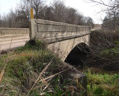 | Deering Bridge | structure | 1992 | 92000748 |
 | Fairfield Carnegie Library | building | 2001 | 01001274 |
| Glenvil Fire Hall and Town Jail | building | 2022 | 100007937 | |
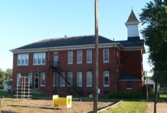 | Glenville School | building | 1998 | 98001566 |
| Harvard Carnegie Library | building | 2022 | 100007504 | |
 | Inland School | building | 2002 | 02000271 |
 | Saint Martin's Catholic Church | building | 1985 | 85002574 |
Every wildfire the federal occurrence database records inside this county: 55 of them, burning about 874 acres. 1 started naturally and 1 was recorded as arson. Each settlement page carries the fires within five miles of it.
| Reported cause | Fires |
|---|---|
| Missing data/not specified/undetermined | 23 |
| Equipment and vehicle use | 12 |
| Debris and open burning | 11 |
| Power generation/transmission/distribution | 3 |
| Recreation and ceremony | 2 |
| Railroad operations and maintenance | 1 |
| Natural | 1 |
| Smoking | 1 |
| Arson/incendiarism | 1 |
The five largest, by the area the report gives. One of them was set deliberately.
| Date | Cause | Size | Reported by | Name on the report |
|---|---|---|---|---|
| 6 March 2017 | Power generation/transmission/distribution | 408 acres | Nebraska Forest Service | not named |
| 18 February 1995 | Arson/incendiarism | 160 acres | Rainwater Basin Wetland Management District | LANGE |
| 7 April 2016 | Equipment and vehicle use | 55 acres | Rainwater Basin Wetland Management District | WINDY HARVARD |
| 16 November 2020 | Missing data/not specified/undetermined | 43 acres | Nebraska Forest Service | not named |
| 27 February 2016 | Equipment and vehicle use | 43 acres | Nebraska Forest Service | not named |
| 7 April 2016 | Power generation/transmission/distribution | 28 acres | Nebraska Forest Service | not named |
| 4 May 2010 | Equipment and vehicle use | 20 acres | Nebraska Forest Service | not named |
| 8 December 2010 | Missing data/not specified/undetermined | 12 acres | Rainwater Basin Wetland Management District | MCMURTREY |
Every settlement page carries the fires within five miles of it - see the settlement index below.
The NOAA Storm Events Database holds 623 reports for this county, causing no deaths, 5 injuries and about $96,467,810 in recorded property damage. Each settlement page carries the reports that name it.
| Kind of event | Reports |
|---|---|
| Hail | 295 |
| Thunderstorm Wind | 227 |
| Tornado | 52 |
| Heavy Rain | 31 |
| Flash Flood | 8 |
| Lightning | 4 |
| Flood | 4 |
| Funnel Cloud | 2 |
The most serious of them, by death, then injury, then recorded damage. The accounts are quoted exactly as the forecast office filed them.
| When | Event | Place named | Harm | What the report says |
|---|---|---|---|---|
| March 1990 | Tornado (F4) | not stated | 3 hurt, $25,000,000 | no account filed |
| July 1994 | Thunderstorm Wind | Sutton | 2 hurt, $5,000,000 | no account filed |
| May 2014 | Tornado (EF3) | Fairfield | $12,500,000 | This tornado was reported initially as a multi-vortex tornado for several miles before taking on a more traditional look south of Saronville, where it was described as a wedge tornado. Based upon reports and video, it appears the entire mesocyclone of the storm was near ground level southwest of Sutton. It was one of the strongest tornado of the day in south central Nebraska, rated an EF3 with the peak wind estimated to be 150 MPH. Rear flank downdraft winds resulted in damage on the south side of the tornado track and in addition to the damage to Sutton itself, areas east of Clay Center, southwest of Sutton through northwest of Grafton were affected. Power poles and trees were damaged or snapped, irrigation pivots were overturned, and a few homes and outbuildings suffered damage.||Damage from this tornado was first noted north of Fairfield, where large tree limbs were knocked down and power poles broken. The tornado shifted mainly east across Highway 14 south of Clay Center, with additional tree damage as well as irrigation pivots overturned. It then started to move to the northeast, crossing Highway 41 east of Clay Center and Highway 6 a few miles west of Sutton, but powerful rear flank downdraft winds of 100 mph hammered Sutton and areas south-southwest of town, causing widespread property damage. Moving in between Saronville and Sutton, the tornado then started a more east-northeast path, crossing Road 6 north of Sutton before dissipating approximately 5 miles northeast of town.||As the tornado approached and crossed Highway 6 it intensified to it strongest point. Damage peaked a few miles north of Sutton, where the EF-3 rating was assigned, resulting from the destruction of a home. Elsewhere along the path, a few other homes sustained less significant damage than the one north of Sutton, and a number of other outbuildings and grain bins were also damaged or destroyed. Many trees were damaged, destroyed or contained debris (mainly from destroyed grain bins), irrigation pivots were overturned and power poles broken. |
| May 2013 | Thunderstorm Wind | Ong | $6,000,000 | Wind gusts were estimated to be near 90 MPH, resulting in tree damage, overturned pivots and snapped power poles. |
| July 2021 | Thunderstorm Wind | Trumbull | $5,000,000 | Wind gusts estimated to be near 95 MPH occurred along this path. The main reports of damage came from the Harvard and Sutton areas. Widespread tree damage was reported, along with large areas of flattened crops. Minor roof damage occurred in Sutton. Numerous power outages were reported. Emergency management reported multiple irrigation pivots overturned in the area, along with 3 large grain bins destroyed and an outbuilding damaged along N Road near Harvard. |
| May 2004 | Tornado (F2) | Spring Ranch | $4,500,000 | A large tornado moved out of Adams county and into central Clay county. Approximately 15 residences were hit by the tornado. Thirty-eight cars of a forty-nine car Union Pacific train were derailed southeast of Glenvil. Over 100 center irrigation pivots were damaged or destroyed across Clay County. |
| May 2013 | Tornado (EF2) | Edgar | $4,000,000 | This EF2 tornado touched down during the early evening hours just west of Edgar and was on the ground between 5 and 10 minutes before lifting just southeast of Edgar. The maximum speed was estimated at 115 MPH with a maximum width of 250 yards. Damage along the path included snapped power poles, overturned irrigation pivots, grain bin and outbuilding damage. In Edgar itself, a large metal building was destroyed, other buildings suffered minor damage and the grain elevator was damaged. |
| May 2025 | Hail | Edgar | $3,000,000 | Hail in Edgar was mainly less than two inches in diameter, but the largest stones were near the size of baseballs. |
| April 1978 | Tornado (F2) | not stated | $2,500,000 | no account filed |
| June 2022 | Thunderstorm Wind | Saronville | $2,000,000 | Peak wind gusts estimated to be around 95 MPH caused widespread damage along and near this path. Numerous power poles were damaged, including several that were snapped. Tree damage was reported, and several irrigation pivots were overturned. Outbuilding damage occurred, and a grain bin just west of Saronville was shifted off its foundation and crumpled. A shed was overturned north of Sutton. |
| May 2023 | Hail | Edgar | $1,500,000 | Hail up to the size of tennis balls was reported in Edgar. |
| August 2007 | Thunderstorm Wind | Saronville | $1,500,000 | At least 80 mph winds toppled a newly constructed 125 foot tall grain bin and pulled the anchor bolts out of the cement foundation. |
| September 2001 | Tornado (F3) | Edgar | $1,250,000 | Tornado exited Clay county and entered Fillmore county. |
| May 2025 | Hail | Deweese | $1,000,000 | Quarter to ping pong ball size hail was reported. |
| June 2022 | Hail | Trumbull | $1,000,000 | Hail as large as tennis balls was reported in Trumbull. |
| July 2021 | Thunderstorm Wind | Fairfield | $1,000,000 | A wind gust of 76 MPH was recorded by a mesonet station located two miles west-northwest of Fairfield at 11:09 PM CDT. A wind gust of 61 MPH was recorded by a mesonet station located four miles northeast of Fairfield at 11:11 PM CDT. The Cooperative Observer located six miles east-southeast of Clay Center estimated wind speeds of at least 70 MPH. |
| August 2020 | Hail | Sutton | $1,000,000 | Hail ranging in size from half dollars to baseballs was reported in Sutton. |
| June 2014 | Thunderstorm Wind | Inland | $1,000,000 | A line of thunderstorms with damaging wind gusts up to 80 MPH moved across the county. Damage was reported in the Inland, Clay Center and Saronville areas, including large trees being downed, with one ending up across the westbound lane of Highway 6. |
| August 2013 | Thunderstorm Wind | Edgar | $1,000,000 | A grain bin was blown onto train tracks and was hit by a train. A railroad employee reported that machinery from Grand Island was brought in to remove the bin from the tracks. This apparently took rather large machinery to perform this task. The tracks were finally cleared by 430 am CDT on August 2nd. Golfball size hail also occurred. |
| August 2013 | Hail | Edgar | $1,000,000 | Also, a grain bin was blown onto train tracks and was hit by a train. A railroad employee reported that machinery from Grand Island was brought in to remove the bin from the tracks. This apparently took rather large machinery to perform this task. The tracks were finally cleared by 430 am CDT on August 2nd. |
| August 2013 | Thunderstorm Wind | Edgar | $1,000,000 | A very large and healthy tree snapped at the base and fell onto the roof of a home. The base of the trunk was conservatively estimated at 2 feet in diameter. |
| July 2023 | Tornado (EF1) | Sutton | $750,000 | A brief tornado developed within a long-lived line of thunderstorms just prior to 7 AM CDT on July 29th. This tornado moved from northwest to southeast across the town of Sutton. The first visible damage occurred as the tornado developed on the northwest edge of Sutton. Tree damage was the most obvious damage in this area, with several large branches snapped. Some small outbuildings were also overturned and damaged, along with minor damage to homes, including windows, doors and siding. Roofing damage was limited in the early portions of the path. Most notable damage occurred in the downtown area of Sutton, where a steel roof was peeled off of a downtown building and lofted about one block to the south. There was also damage to brickwork on buildings, presumably as this roof was dragged across the top of adjacent buildings. This is where the estimated peak wind speeds of 110 MPH occurred. The tornado then continued southeast, snapping several trees across the southeast half of town. An old garage was also swept off of its foundation and blown into a nearby home and garage, causing significant damage to those buildings. Finally the tornado passed onto the golf course on the southeast edge of town. A maintenance building was severely damaged and several healthy trees were snapped. From here, the tornado passed into a corn field, producing a small path of crop damage. The tornado appeared to have lifted less than one-half mile southeast of Sutton. |
| July 2006 | Thunderstorm Wind | Edgar | $500,000 | no account filed |
| July 2023 | Hail | Saronville | $250,000 | Hail up to the size of tennis balls was reported along and near this path. |
| July 2023 | Hail | Saronville | $250,000 | Reports received via social media and broadcast media of hail between three and four inches in diameter in and around Saronville. |
| May 2022 | Thunderstorm Wind | Clay Center | $250,000 | Wind gusts estimated to be near 70 MPH resulted in damage across Clay Center. Emergency management reported widespread tree damage and power outages across town and much of Clay County. A couple metal buildings in town sustained damage, including one at the grain elevator. A few power poles were also damaged. |
| June 2022 | Thunderstorm Wind | Edgar | $250,000 | A wind gust of 69 MPH was measured by a mesonet station located one mile north-northwest of Edgar. An NeRAIN comment noted that there was crop damage in the area. |
| June 2022 | Hail | Edgar | $250,000 | An NeRAIN observer reported hail up to ping pong ball size. |
| June 2015 | Flood | Trumbull | $250,000 | Multiple rounds of heavy rainfall totaled generally 4-7 across much of Clay County between the 3rd-6th, with the majority of this rain falling on the 4th-5th. Localized road flooding was initially reported across parts of the county on the evening of the 4th. Over the next few days, the main story turned to the West Fork Big Blue River and its smaller stream tributaries in the northern part of the county, as the cumulative effects of multiple rounds of heavy rain resulted in significant flooding, mainly on the 5th-6th. Reports indicated that this may have been some the worst flooding observed along the west fork Big Blue in 50-80 years. A few days of warm and dry weather settled in from June 7-9, allowing flood waters to largely recede. |
| April 2012 | Hail | Sutton | $250,000 | A few homes in Sutton suffered broken windows. |
| May 2025 | Hail | Fairfield | $250,000 | no account filed |
| August 2007 | Thunderstorm Wind | Clay Center | $250,000 | no account filed |
| June 2001 | Thunderstorm Wind | Edgar | $250,000 | no account filed |
| July 2000 | Lightning | Inland | $250,000 | no account filed |
| June 1991 | Tornado (F1) | not stated | $250,000 | no account filed |
| April 1991 | Tornado (F2) | not stated | $250,000 | no account filed |
| April 1976 | Tornado (F2) | not stated | $250,000 | no account filed |
| April 1957 | Tornado (F3) | not stated | $250,000 | no account filed |
| April 2024 | Thunderstorm Wind | Clay Center | $200,000 | Wind gusts were estimated to be between 60 and 70 MPH by the NWS Cooperative Observer located six miles east-southeast of Clay Center. Clay County Emergency management reported two irrigation pivots were knocked over four miles north of Clay Center. |
| May 2013 | Tornado (EF1) | Clay Center | $200,000 | This was the second tornado to touch down approximately 2 miles north-northeast of Clay Center this day, with this one traveling along a 4 mile path before lifting 6 miles north-northeast of Clay Center. This tornado had a maximum width of 75 yards and maximum wind speed estimated to be 100 MPH. One home suffered minor damage, as did an outbuilding, with metal panels being pulled from the roof and walls. |
| May 2012 | Hail | Deweese | $200,000 | Hail up to the size of hen eggs resulted in tree damage around the area. |
| April 2012 | Thunderstorm Wind | Clay Center | $200,000 | Wind gusts estimated at 70 mph resulted in a few center irrigation pivots being overturned. |
| March 2006 | Thunderstorm Wind | Harvard | $200,000 | no account filed |
| June 1998 | Thunderstorm Wind | Fairfield | $200,000 | no account filed |
| June 1998 | Thunderstorm Wind | Deweese | $200,000 | no account filed |
| May 1998 | Thunderstorm Wind | Fairfield | $200,000 | no account filed |
| May 1998 | Thunderstorm Wind | Glenville | $200,000 | no account filed |
| May 2024 | Thunderstorm Wind | Fairfield | $175,000 | Wind gusts were estimated to be near 70 MPH. Emergency management reported a large tree downed near the intersection of Road 310 and Road L. Two irrigation pivots were flipped approximately six miles southeast of Clay Center, and minor porch and tractor damage was reported at a farmstead approximately six miles east-southeast of Clay Center. |
| July 2023 | Thunderstorm Wind | Eldorado | $150,000 | Wind gusts estimated to be near 60 MPH were accompanied by hail up to two inches in diameter. |
| July 2023 | Hail | Eldorado | $150,000 | Hail up to two inches in diameter was accompanied by wind gusts estimated to be near 60 MPH. |
| December 2021 | Tornado (EF0) | Trumbull | $150,000 | This tornado touched down in extreme northeast Adams County south of Trumbull, crossed through far northwest Clay County before heading into southwest Hamilton County. This intermittent tornado damaged a horse barn south of Trumbull as it began its roughly seven-mile path. As it moved northeast, most of the observable damage was to a couple of irrigation pivots along with a snapped tree. The estimated maximum wind gust was 75 MPH. |
| June 2018 | Thunderstorm Wind | Ong | $150,000 | Damage occurred to a few homesteads about eight to nine miles south and about one mile west of Sutton. Two carports were destroyed, with one being blown out into a neighbor's field. Two hog sheds were badly damaged at another location. One home sustained roof damage. The roof of the garage was severely damaged and at least partially removed. Part of the roof was damaged where it met the garage and allowed heavy rain into the home. The observer noted that things were all blown in the same direction, indicating straight-line wind. |
| May 2014 | Hail | Glenville | $150,000 | Ping pong to tennis ball size hail was reported. |
| August 2013 | Thunderstorm Wind | Clay Center | $150,000 | Numerous large trees fell onto homes. |
| August 2007 | Flash Flood | Clay Center | $150,000 | Flash flooding throughout the county with many county roads under water. |
| May 2018 | Hail | Clay Center | $150,000 | no account filed |
| August 2013 | Thunderstorm Wind | Inland | $125,000 | An irrigation pivot and large tree branches were blown onto Highway 6. A farm storage shed was destroyed. Severe crop damage also occurred. |
| June 1998 | Hail | Clay Center | $125,000 | no account filed |
| July 2024 | Thunderstorm Wind | Clay Center | $100,000 | A wind gust of 72 MPH was measured by a mesonet station located three miles west-northwest of Clay Center and a gust of 71 MPH was measured by a mesonet station located one mile southeast of Clay Center. The NWS Cooperative Observer located six miles east-southeast of Clay Center estimated gusts to be between 60 and 70 MPH and reported downed tree limbs, some up to 8 inches in diameter. Tree damage was also reported in Clay Center. This wind was accompanied by dime size hail. |
| May 2023 | Hail | Deweese | $100,000 | Hail up to the size of golf balls was reported along this path. |
The Survey's mineral resources record lists 1 working inside this county. It still produces. Each settlement page carries the workings within five miles of it.
| Commodity | Workings |
|---|---|
| Sand and Gravel, Construction | 1 |
The least common of them first, because a county's hundredth gravel pit says nothing its first ten did not.
| Where | Site | Commodity | Status | Recorded |
|---|---|---|---|---|
| Broderick Pit | Sand and Gravel, Construction | Producer |
The 'centennial' Sketch of Clay County, Nebraska devotes a chapter to each township: its boundaries and streams, who settled it and when, the mills, the schools and the churches. All 3 are reproduced here in full. Each row shows the township's own shape and where it lies in the county, drawn from the Census Bureau's boundary. Which settlements belong to which township is computed from that same boundary, not taken from the book.
| Shape and position in the county | Township | Settlements in it | Length | Sections |
|---|---|---|---|---|
| Lewis Township | Saronville, Verona | 123 words | 0 | |
| Logan Township | Ong | 3,409 words | 4 | |
| Sutton City | Sutton | 1,034 words | 0 |
Named settlements recorded in the Geographic Names Information System, each with the topographic sheets covering it. Villages, hamlets and abandoned places alike. Each is shown with the nearest named watercourse or landform and the survey quadrangle it falls on.
Spring Ranch township · 68941 · On Pawnee Creek · Fairfield NW quadrangle
11 sheets, 1898 to 1985
No longer a settlement
The vanished settlements of Clay County: the places named above that are no longer on the map.