 Block
From the record
4 National Register listings published here.
Sources: the county history on the Internet Archive · the National Register database, National Park Service
22 topographic sheets cover 12 settlements here, and 4 properties are on the National Register of Historic Places.
4 National Register listings published here.
Sources: the county history on the Internet Archive · the National Register database, National Park Service
Every property in this county listed on the National Register of Historic Places, with the year it was listed and the federal nomination document.
| Photograph | Property | Type | Listed | Reference |
|---|---|---|---|---|
 | Ben Bonderson Farm | building | 2006 | 06000993 |
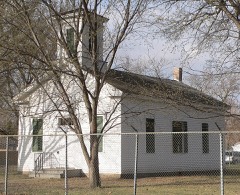 | Emmanuel Lutheran Church | building | 1969 | 69000129 |
 | Meisch House | building | 1986 | 86000387 |
 | Cornelius O'Connor House | building | 1977 | 77000826 |
Every wildfire the federal occurrence database records inside this county: 34 of them, burning about 1,271 acres. 1 started naturally and 2 were recorded as arson. Each settlement page carries the fires within five miles of it.
| Reported cause | Fires |
|---|---|
| Debris and open burning | 13 |
| Missing data/not specified/undetermined | 6 |
| Equipment and vehicle use | 6 |
| Smoking | 2 |
| Arson/incendiarism | 2 |
| Power generation/transmission/distribution | 2 |
| Natural | 1 |
| Recreation and ceremony | 1 |
| Railroad operations and maintenance | 1 |
The five largest, by the area the report gives. None of them was recorded as arson.
| Date | Cause | Size | Reported by | Name on the report |
|---|---|---|---|---|
| 19 April 2008 | Debris and open burning | 560 acres | Nebraska Forest Service | not named |
| 18 April 2014 | Missing data/not specified/undetermined | 130 acres | Nebraska Forest Service | not named |
| 31 March 2014 | Smoking | 125 acres | Nebraska Forest Service | not named |
| 7 November 2010 | Natural | 80 acres | Winnebago Agency | KIM KNECHT |
| 2 May 2009 | Equipment and vehicle use | 80 acres | Nebraska Forest Service | not named |
| 9 April 2008 | Debris and open burning | 60 acres | Nebraska Forest Service | not named |
| 6 May 2017 | Power generation/transmission/distribution | 30 acres | Nebraska Forest Service | not named |
| 9 April 2020 | Missing data/not specified/undetermined | 30 acres | Nebraska Forest Service | not named |
Every settlement page carries the fires within five miles of it - see the settlement index below.
The NOAA Storm Events Database holds 225 reports for this county, causing no deaths, 4 injuries and about $36,715,500 in recorded property damage. Each settlement page carries the reports that name it.
| Kind of event | Reports |
|---|---|
| Hail | 99 |
| Thunderstorm Wind | 83 |
| Flood | 20 |
| Flash Flood | 14 |
| Tornado | 8 |
| Lightning | 1 |
The most serious of them, by death, then injury, then recorded damage. The accounts are quoted exactly as the forecast office filed them.
| When | Event | Place named | Harm | What the report says |
|---|---|---|---|---|
| August 2001 | Tornado (F2) | Jackson | 3 hurt, $3,000,000 | A tornado completely destroyed at least ten houses and heavily damaged several others. The tornado heavily damaged the town school, including taking most of the roof off the school. The only church in town and a telephone company building were also heavily damaged. Power lines, poles, and trees were blown down, and electricity and water service were knocked out. Three empty box cars on the southeast side of Jackson were toppled. Three injuries included a woman with a broken leg and cuts rescued from the rubble of a house, and two children with minor injuries. |
| July 1986 | Tornado (F4) | not stated | 1 hurt, $25,000,000 | no account filed |
| July 1996 | Thunderstorm Wind | South Sioux City | $3,000,000 | no account filed |
| March 2019 | Flood | Emerson | $1,500,000 | Nebraska Highway 26E Spur was closed due to flooding, with water reaching into portions of Ponca. In addition, flooding resulted in extensive damage to public infrastructure including numerous county and township roads, culverts, and some bridges. |
| June 2024 | Flood | Emerson | $1,180,000 | Rainfall amounts across Dakota County from June 20-22 were generally a half inch or less. However, farther north and upstream 6 to 10 plus inches fell across portions of southeast South Dakota and northwest Iowa. Record flood waters along the Vermillion and Big Sioux Rivers emptied into the Missouri River, pushing river levels into minor flooding. ||Missouri River flooding resulted in the evacuation of the Lower Scenic Park Campground and damage to parts of the park, including the soccer fields and some campground electrical pedestals. The police shooting range was also damaged. Preliminary damage assessments estimate loss to public infrastructure to be nearly 1.18 million dollars. ||For additional information on river flooding, please see other flood entries for Dakota County. |
| July 1996 | Flash Flood | Jackson | $1,000,000 | no account filed |
| July 2002 | Thunderstorm Wind | Jackson | $500,000 | Thunderstorm winds caused widespread damage to trees and structures. The worst structural damage was on a farm just south of Jackson where two barns and a windmill were totally destroyed, shingles on the roof of the house were blown off, an air conditioner was destroyed, five horses were injured, and electricity was cut off. In Jackson, shingles were blown off the roofs of buildings, siding was damaged from wind blown debris, and a few homes suffered damage when large branches fell. Major tree damage in Jackson included a few large trees blown over. Power lines and poles were blown down or damaged by falling trees, resulting in power outages. |
| July 1996 | Hail | South Sioux City | $500,000 | no account filed |
| July 1996 | Thunderstorm Wind | Willis | $300,000 | no account filed |
| July 1999 | Hail | South Sioux City | $200,000 | no account filed |
| August 2011 | Hail | Hubbard | $100,000 | Large hail caused widespread damage to crops, vehicles, and windows. |
| July 2002 | Hail | Jackson | $100,000 | Large hail, driven by severe winds, damaged siding on homes, and also dented vehicles. |
| July 2008 | Thunderstorm Wind | South Sioux City | $50,000 | Thunderstorm winds blew down numerous trees and power lines, and caused other widespread tree damage. At least one house and a camper were damaged by falling trees. A few street lights were also knocked down. |
| June 2003 | Hail | Jackson | $50,000 | Large hail damaged vehicles and cracked windows. |
| June 2001 | Thunderstorm Wind | South Sioux City | $50,000 | Thunderstorm winds cause tree and power line damage, including numerous trees blown down. |
| July 1996 | Tornado (F0) | Jackson | $50,000 | no account filed |
| June 2003 | Thunderstorm Wind | Jackson | $20,000 | Thunderstorm winds caused widespread tree damage, including several trees blown down. There was also damage to power lines, and at least two buildings received minor damage from wind blown debris. |
| July 2002 | Thunderstorm Wind | Homer | $20,000 | Thunderstorm winds severely damaged grain elevators on a farm, and caused tree damage. |
| May 2011 | Thunderstorm Wind | Emerson | $10,000 | Thunderstorm winds blew over a large semi truck. |
| June 2010 | Thunderstorm Wind | Jackson | $10,000 | Thunderstorm winds caused tree damage including large limbs blown down. A house was damaged by tree debris. |
| June 2010 | Thunderstorm Wind | Dakota City | $10,000 | Thunderstorm winds caused widespread tree damage, including several large trees uprooted or blown down. A flagpole was also blown down. |
| August 2003 | Thunderstorm Wind | Homer | $10,000 | Thunderstorm winds caused tree damage, including several trees down. One tree fell on and damaged a house. |
| June 2000 | Thunderstorm Wind | Jackson | $10,000 | Thunderstorm winds caused tree damage. |
| October 2019 | Flood | Willis | $5,000 | A continuation from September, the Missouri River at Ponca (gage site MRPN1) started the month at 0.55 feet above flood stage on October 1, and fell below flood stage on October 4. Property damage costs are rough estimates. |
| September 2019 | Flood | Willis | $5,000 | Runoff from heavy rainfall (4.59 inches at Hurley, 4.24 inches at Menno, and 8.14 inches at Clayton) brought the Missouri River at Ponca (gage site MRPN1) to a crest 3.06 feet above flood stage on September 15. The river remained in minor flood stage at the end of the month. |
| May 2011 | Thunderstorm Wind | South Sioux City | $5,000 | Thunderstorm winds blew down light poles. |
| August 2009 | Thunderstorm Wind | Jackson | $5,000 | Thunderstorm winds caused tree damage. A large tree on the west side of the town of Jackson was blown down across a road, and trees up to 5 inches in diameter were broken off in the town. |
| July 1995 | Thunderstorm Wind | Homer | $5,000 | Thunderstorm winds blew down some small trees. |
| July 1996 | Lightning | South Sioux City | $5,000 | no account filed |
| July 1996 | Hail | Dakota City | $5,000 | no account filed |
| July 1996 | Thunderstorm Wind | Dakota City | $5,000 | no account filed |
| May 1995 | Thunderstorm Wind | S. Sioux City | $3,000 | ,,,,,,,,(G60) Thunderstorm winds blew the roof off of a horse stable. |
| June 1987 | Tornado (F0) | not stated | $2,500 | no account filed |
| July 2024 | Flash Flood | South Sioux City | - | A car was stalled in flood waters along South Ridge Drive near U.S. Highway 77. |
| July 2024 | Thunderstorm Wind | South Sioux City | - | Several large tree limbs were downed around South Sioux City, some on top of vehicles or residential structures. |
| June 2024 | Flood | Willis | - | The Missouri River near Ponca rose above flood stage the morning of June 24th, cresting around 0.93 feet above flood stage (20.93 feet) on June 26th. The river then fell below flood stage on the morning of June 27th. For a more comprehensive description of flood damage, please see other entries for Dakota County. |
| June 2024 | Flood | Willis | - | The Missouri River at Sioux City rose above flood stage the evening of June 24th, cresting around 2.23 feet above flood stage (32.23 feet) on June 25th. The river then fell below flood stage on the morning of June 27th. For a more comprehensive description of flood damage, please see other entries for Dakota County. |
| June 2023 | Thunderstorm Wind | Homer | - | Thunderstorm winds snapped several large trees and caused minor roof damage to a couple of houses. |
| July 2023 | Thunderstorm Wind | Jackson | - | Thunderstorm winds downed a tree roughly 30 feet tall and 12 inches in diameter, which blocked the westbound lane of U.S. Highway 20 in Jackson. |
| July 2023 | Thunderstorm Wind | Jackson | - | Thunderstorm winds downed several tree limbs up to 3 inches in diameter. |
| May 2022 | Thunderstorm Wind | Homer | - | A brief gustnado developed along the storm outflow, but no damage was noted. |
| June 2020 | Hail | Willis | - | Hail was found and measured three hours after occurrence. |
| June 2020 | Hail | Willis | - | The hail was accompanied by winds strong enough to break 2 inch diameter branches from trees. |
| October 2020 | Thunderstorm Wind | Nacora | - | Wind gusts occurred within the heavy rain core, but there was no hail. Crops appeared undamaged by the wind. |
| June 2019 | Flood | Willis | - | A continuation of flooding from May, the Missouri River near Ponca (gage site MRPN1) crested 2.47 feet above flood stage on June 1. High water closed numerous recreational boat ramps. |
| June 2019 | Flood | Willis | - | A continuation of flooding from May, the Missouri River at Sioux City (gage site SSCN1) crested 0.27 feet above flood stage on June 1. Some minor flooding of Sioux City parks near the river occurred, along with water briefly onto portions of Hamilton Boulevard near Interstate 29. |
| June 2019 | Flood | Emerson | - | During crop planting season, prolonged flooding led to the loss of or inability to plant crops across the area. Crop loss estimates provided by the United States Department of Agriculture. |
| March 2019 | Flood | South Sioux City | - | Multiple road closures in South Sioux City. Reports received via social media. |
| March 2019 | Flood | Laketon | - | Highway 75 closed between Dakota City and Winnebago due to flooding. |
| May 2019 | Flood | Willis | - | Increased releases from upstream Gavins Point Dam along with runoff from heavy rainfall over the preceding week produced moderate flooding on the Missouri River near Ponca (gage site MRPN1). Agricultural areas near the river were inundated as the river rose to 2.46 feet above flood stage on May 31. The river remained in moderate flood stage at the end of the month. |
| May 2019 | Flood | Willis | - | Increased releases from upstream Gavins Point Dam along with runoff from heavy rainfall over the preceding week produced minor flooding on the Missouri River at Sioux City (gage site SSCN1). Hamilton Boulevard and a few park areas along the river near Interstate 29 were flooded as the river rose to 0.22 feet above flood stage on May 31. The river remained in minor flood stage at the end of the month. |
| March 2019 | Flood | Homer | - | Snow melt and heavy rainfall (measured 1.70 inches 3 miles southwest of Hubbard and 1.63 inches at Emerson) resulted in significant flooding of agricultural lands, as Omaha Creek at Homer (gage site HMRN1) crested at 3.46 feet above flood stage on March 13. |
| June 2017 | Hail | South Sioux City Arp | - | Several tree branches were also downed. |
| June 2017 | Thunderstorm Wind | South Sioux City | - | A few branches were downed. |
| June 2017 | Thunderstorm Wind | South Sioux City | - | Tree branches downed. |
| August 2016 | Thunderstorm Wind | Homer | - | Thunderstorm winds caused tree damage, including at least one tree blown down. |
| August 2016 | Thunderstorm Wind | Homer | - | Thunderstorm winds blew down trees and power lines. |
| July 2015 | Thunderstorm Wind | South Sioux City | - | Thunderstorm winds caused tree damage, including two 18 inch diameter trees and numerous smaller branches blown down. |
| August 2014 | Thunderstorm Wind | Coburn | - | Thunderstorm winds caused tree damage, including several branches blown down. |
| August 2014 | Thunderstorm Wind | Dakota City | - | Thunderstorm winds caused tree damage, including a few large trees blown down. |
Warner's History of Dakota County, Nebraska, from the Days of the Pioneers and First Settlers to the Present Time, with Biographical Sketches, and Anecdotes of Ye Olden Times devotes a chapter to each township: its boundaries and streams, who settled it and when, the mills, the schools and the churches. All 2 are reproduced here in full. Each row shows the township's own shape and where it lies in the county, drawn from the Census Bureau's boundary. Which settlements belong to which township is computed from that same boundary, not taken from the book.
| Shape and position in the county | Township | Settlements in it | Length | Sections |
|---|---|---|---|---|
| Dakota City City | Dakota City | 2,805 words | 2 | |
| South Sioux City City | Covington, South Sioux City | 838 words | 2 |
One book written about this county, cut here where the book itself is cut, at its printed chapters: 18 chapters in all. Every chapter is public domain, machine-read from the scan and reproduced complete. A chapter already given under one of the county's towns is not repeated in this list.
| Chapter | Length |
|---|---|
| Chapter 1 | 2,687 words |
| Chapter 2 | 790 words |
| Chapter 3 | 846 words |
| Chapter 4 | 508 words |
| Chapter 5: Extinct Towns | 1,826 words |
| Chapter 6: Dakota County Towns | 9,649 words |
| Chapter 7 | 1,558 words |
| Chapter 8 | 1,216 words |
| Chapter 10 | 700 words |
| Chapter 11 | 713 words |
| Chapter 12 | 698 words |
| Chapter 15 | 1,289 words |
| Chapter 16 | 2,478 words |
| Chapter 17 | 39,450 words in 3 parts |
| Chapter 18 | 8,134 words |
| Chapter 19 | 4,806 words |
| Chapter 20 | 528 words |
| Chapter 22 | 888 words |
Named settlements recorded in the Geographic Names Information System, each with the topographic sheets covering it. Villages, hamlets and abandoned places alike. Each is shown with the nearest named watercourse or landform and the survey quadrangle it falls on.
South Sioux City city · 68776 · Sioux City South quadrangle
13 sheets, 1955 to 1993
No longer a settlement
South Sioux City city · 68776 · Sioux City South quadrangle
13 sheets, 1955 to 1993
The vanished settlements of Dakota County: the places named above that are no longer on the map.