 Block
From the record
2 National Register listings published here.
Sources: the National Register database, National Park Service
34 topographic sheets cover 11 settlements here, and 2 properties are on the National Register of Historic Places.
2 National Register listings published here.
Sources: the National Register database, National Park Service
Every property in this county listed on the National Register of Historic Places, with the year it was listed and the federal nomination document.
| Photograph | Property | Type | Listed | Reference |
|---|---|---|---|---|
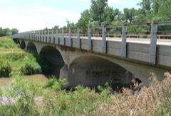 | Cambridge State Aid Bridge | structure | 1992 | 92000763 |
 | W.H. Faling House | building | 1999 | 99001388 |
Every wildfire the federal occurrence database records inside this county: 83 of them, burning about 1,047 acres. 4 started naturally and none was recorded as arson. Each settlement page carries the fires within five miles of it.
| Reported cause | Fires |
|---|---|
| Debris and open burning | 24 |
| Missing data/not specified/undetermined | 23 |
| Equipment and vehicle use | 22 |
| Power generation/transmission/distribution | 8 |
| Natural | 4 |
| Fireworks | 1 |
| Recreation and ceremony | 1 |
The five largest, by the area the report gives. None of them was recorded as arson.
| Date | Cause | Size | Reported by | Name on the report |
|---|---|---|---|---|
| 17 April 2011 | Debris and open burning | 400 acres | Nebraska Forest Service | not named |
| 5 March 2018 | Missing data/not specified/undetermined | 375 acres | Nebraska Forest Service | not named |
| 7 July 2007 | Equipment and vehicle use | 40 acres | Nebraska Forest Service | not named |
| 26 November 2017 | Equipment and vehicle use | 25 acres | Nebraska Forest Service | not named |
| 5 October 2007 | Equipment and vehicle use | 25 acres | Nebraska Forest Service | not named |
| 26 November 2017 | Equipment and vehicle use | 20 acres | Nebraska Forest Service | not named |
| 4 October 2011 | Equipment and vehicle use | 20 acres | Nebraska Forest Service | not named |
| 2 July 2005 | Missing data/not specified/undetermined | 10 acres | Nebraska Forest Service | not named |
Every settlement page carries the fires within five miles of it - see the settlement index below.
The NOAA Storm Events Database holds 564 reports for this county, causing 1 death, no injuries and about $18,112,250 in recorded property damage. Each settlement page carries the reports that name it.
| Kind of event | Reports |
|---|---|
| Hail | 321 |
| Thunderstorm Wind | 180 |
| Tornado | 30 |
| Heavy Rain | 17 |
| Flash Flood | 7 |
| Flood | 6 |
| Lightning | 3 |
The most serious of them, by death, then injury, then recorded damage. The accounts are quoted exactly as the forecast office filed them.
| When | Event | Place named | Harm | What the report says |
|---|---|---|---|---|
| June 1969 | Tornado (F2) | not stated | 1 killed, $25,000 | no account filed |
| June 2023 | Hail | Wilsonville | $1,000,000 | Hail up to three inches in diameter resulted in numerous broken windows and siding damage. This hail was accompanied by wind gusts near 70 MPH. |
| June 2023 | Hail | Beaver City | $1,000,000 | Extensive home and vehicle damage was reported from hail up to baseball size, driven by wind gusts near 70 MPH. |
| June 2023 | Hail | Wilsonville | $1,000,000 | A cluster of thunderstorms sliding east just north of the Nebraska-Kansas state line produced widespread severe weather across central and southern portions of Furnas County. Hail generally up to the size of golf balls was reported across this area, though isolated larger hail fell west of Wilsonville (3 inches in diameter) and in Beaver City (baseball size). Wind gusts were estimated to be anywhere from 60 to 70 MPH, resulting in numerous reports of tree damage, including whole trees snapped and larger limbs downed. The wind-driven large hail resulted in widespread damage to crops, siding, windows, and vehicles. |
| June 2023 | Thunderstorm Wind | Wilsonville | $1,000,000 | A cluster of thunderstorms sliding east just north of the Nebraska-Kansas state line produced widespread severe weather across central and southern portions of Furnas County. Hail generally up to the size of golf balls was reported across this area, though isolated larger hail fell west of Wilsonville (3 inches in diameter) and in Beaver City (baseball size). Wind gusts were estimated to be anywhere from 60 to 70 MPH, resulting in numerous reports of tree damage, including whole trees snapped and larger limbs downed. The wind-driven large hail resulted in widespread damage to crops, siding, windows, and vehicles. |
| June 2014 | Thunderstorm Wind | Cambridge | $1,000,000 | A line of thunderstorms moved through Furnas County, with wind gusts estimated as high as 80 MPH. There was a measured gust of 60 MPH near Edison at 10:14 p.m. CDT. Across roughly the northern half of Furnas County, power poles and large tree limbs were downed, with some trees completely blown over. A barn was destroyed approximately 7 miles south of Cambridge. The town of Arapahoe lost power. |
| June 2014 | Hail | Cambridge | $1,000,000 | no account filed |
| June 2000 | Thunderstorm Wind | Beaver City | $1,000,000 | no account filed |
| June 2018 | Hail | Arapahoe | $750,000 | Quarter to golf ball size hail fell for approximately 20 minutes. Heavy damage occurred from large hail. Several vehicles were damaged that included busted out windows. There was also damage to homes with substantial holes to siding. The crops south of town sustained a large amount of damage as well. |
| September 2007 | Hail | Oxford | $500,000 | no account filed |
| May 2004 | Tornado (F1) | Beaver City | $300,000 | A tornado traveled a 3 mile path in southeast Furnas county and was witnessed by many people. One farmstead sustained damage to several outbuildings but the house did not have significant damage. A little farther down the road a tractor and six row planter were overturned on top of a car. |
| May 2024 | Thunderstorm Wind | Cambridge | $250,000 | Hail up to golf ball size was accompanied by wind gusts estimated to be near 70 MPH. |
| May 2024 | Hail | Cambridge | $250,000 | Hail up to golf ball size was accompanied by wind gusts estimated to be near 70 MPH. |
| July 2023 | Hail | Arapahoe | $250,000 | Hail up to two inches in diameter was reported in the area, with hail covering part of Highway 283 south of Arapahoe. |
| July 2022 | Thunderstorm Wind | Holbrook | $250,000 | Wind gusts were estimated to be near 60 MPH in Holbrook, where a few large tree limbs were downed. A few miles east of Holbrook, gusts likely closer to 80 MPH caused damage at a farmstead. An outbuilding and grain bin were destroyed, and the roof of a two-car garage was damaged. Hail up to the size of half dollars also occurred. |
| July 2022 | Hail | Holbrook | $250,000 | Hail up to the size of half dollars was accompanied by wind gusts in the area ranging between 60-80 MPH. Wind gusts were estimated to be near 60 MPH in Holbrook, where a few large tree limbs were downed. A few miles east of Holbrook, gusts likely closer to 80 MPH caused damage at a farmstead. An outbuilding and grain bin were destroyed, and the roof of a two-car garage was damaged. |
| June 2011 | Thunderstorm Wind | Cambridge | $250,000 | Wind gusts were estimated between 60 and 70 MPH. Damage reports included main transmission lines being blown down, uprooted trees and roof damage, an overturned stock trailer and grain cart, and air conditioning unit and window damage at the local hospital. |
| June 2023 | Hail | Beaver City | $250,000 | no account filed |
| June 2022 | Hail | Holbrook | $250,000 | no account filed |
| June 2014 | Hail | Arapahoe | $250,000 | no account filed |
| October 1956 | Tornado (F3) | not stated | $250,000 | no account filed |
| August 2005 | Lightning | Oxford | $200,000 | no account filed |
| June 2000 | Thunderstorm Wind | Wilsonville | $200,000 | no account filed |
| June 2000 | Hail | Arapahoe | $200,000 | no account filed |
| June 2000 | Thunderstorm Wind | Beaver City | $200,000 | no account filed |
| June 1999 | Thunderstorm Wind | Beaver City | $200,000 | no account filed |
| July 1996 | Thunderstorm Wind | Edison | $180,000 | no account filed |
| June 1996 | Flood | Various Locations | $180,000 | no account filed |
| May 2022 | Hail | Edison | $150,000 | Hail between quarter and ping pong ball size was reported in Edison. |
| August 2021 | Thunderstorm Wind | Hendley | $150,000 | A handheld anemometer measured gusts of 68 and 71 MPH approximately one mile southwest of Hendley. A trained spotter located four miles west of Beaver City estimated wind gusts near 65 MPH. |
| September 2019 | Hail | Holbrook | $150,000 | Hail stones of 2 to 2.5 inches in diameter was reported along this path. |
| June 2016 | Thunderstorm Wind | Beaver City | $150,000 | An estimated 70 mph thunderstorm wind gust occurred. Part of a tree fell on a house. Also, dime size hail and torrential rain occurred. |
| April 2012 | Hail | Edison | $150,000 | no account filed |
| May 2004 | Thunderstorm Wind | Arapahoe | $150,000 | no account filed |
| May 2004 | Thunderstorm Wind | Wilsonville | $150,000 | no account filed |
| May 2004 | Thunderstorm Wind | Cambridge | $150,000 | no account filed |
| May 2004 | Thunderstorm Wind | Holbrook | $150,000 | no account filed |
| July 2002 | Thunderstorm Wind | Hendley | $150,000 | no account filed |
| October 2023 | Thunderstorm Wind | Beaver City | $125,000 | Wind gusts estimated to be near 75 MPH resulted in damage along this path. At least four metal outbuildings suffered damage, and one old wooden barn was destroyed. Tree damage was reported, and several power poles were also damaged. |
| August 2019 | Hail | Cambridge | $125,000 | Golf ball size hail was accompanied by wind gusts near 70 MPH, with a 71 MPH wind gust measured by a mesonet station. |
| August 2019 | Thunderstorm Wind | Cambridge | $125,000 | A 71 MPH wind gust was measured by a mesonet station located 1 mile west-northwest of Cambridge. These winds were accompanied by quarter to golf ball size hail. Three power poles were snapped on Highway 34 west of Cambridge, and tree damage and downed power poles occurred in Cambridge, including at the Cambridge cemetery. |
| July 2018 | Hail | Holbrook | $100,000 | Quarter to ping pong ball size hail was reported. Hail was accompanied by 60-65 MPH wind gusts. |
| July 2018 | Thunderstorm Wind | Holbrook | $100,000 | A wind gust of 65 MPH was measured in Holbrook and gusts estimated near 60 MPH were reported west of town. Tree limbs of 2-3 inches in diameter were downed in town. Wind was accompanied by quarter to golf ball size hail. |
| August 2015 | Flash Flood | Edison | $100,000 | Multiple roads were under water in and around the Edison area due to flash flooding. In Edison, Ag Valley Coop sustained some of the worst damage as flood waters infiltrated the first floor office. Other homes and buildings in and around Edison were also flooded. As of 4:25 pm CDT, 4.25 inches of rain was reported to have fallen two miles southwest of Edison (fell in one approximately one hour) and washed a dip in a driveway 2 feet deep. By 5 p.m. CDT, rainfall at that location was unofficially up to 5. In addition, the NWS cooperative observer in Edison reported a storm total of 3.74. |
| July 2024 | Hail | Hollinger | $100,000 | no account filed |
| July 2019 | Flash Flood | Oxford | $100,000 | no account filed |
| June 2000 | Thunderstorm Wind | Cambridge | $100,000 | no account filed |
| June 2000 | Thunderstorm Wind | Holbrook | $100,000 | no account filed |
| June 2011 | Thunderstorm Wind | Arapahoe Arpt | $75,000 | Wind gusts were estimated at 70 MPH, resulting in significant damage to a garage and barn. Trees of 1 to 2 feet in diameter, and power lines, were blown down. |
| June 1997 | Hail | Arapahoe | $75,000 | Numerous funnel clouds were reported in Furnas County along with extensive crop damage from the hail. |
| June 2014 | Hail | Arapahoe | $75,000 | no account filed |
| June 2011 | Hail | Cambridge | $75,000 | no account filed |
| June 1997 | Hail | Hollinger | $75,000 | no account filed |
| April 2024 | Hail | Edison | $50,000 | Quarter to half-dollar size hail almost covering the ground was accompanied by wind gusts estimated to be near 60 MPH. A couple of windows were broken on the south side of a home. |
| June 2023 | Thunderstorm Wind | Cambridge | $50,000 | Wind gusts estimated to be near 70 MPH downed tree limbs that were four to six inches in diameter. |
| June 2020 | Hail | Wilsonville | $50,000 | Hail ranging in size from ping pong balls to golf balls was reported along this path. |
| June 2019 | Thunderstorm Wind | Arapahoe | $50,000 | Power poles and power lines were damaged in Arapahoe. A power line was laying across the junction of Highways 34 and 283. Tree limbs with diameters of 6 to 8 inches were downed. Wind gust of 73 mph was measured at the north side of Arapahoe at this time. |
| November 2015 | Tornado (EF1) | Beaver City | $50,000 | This tornado crossed into Nebraska southeast of Beaver City and traveled north-northeast across rural areas of Furnas County south of Hollinger. Damage along the path was primarily to trees, power poles, some signs, outbuildings and small farm machinery. The tornado damaged mainly power poles and trees south of Highway 89. After it crossed Highway 89, the tornado clipped a barn and farm storage area northeast of Hollinger. The western side roof covering was ripped from the barn and several grain carts were moved on the property causing other damage. The maximum width was estimated from damage located approximately 4 miles north of the Kansas state line. The maximum wind speed was estimated to be 95 MPH. |
| September 2013 | Thunderstorm Wind | Oxford | $50,000 | Wind gusts estimated near 70 mph resulted in a tree of 10 to 12 inches in diameter being blown down onto a van. An irrigation pivot was blown over next to Highway 34 near Road 436. |
| March 2012 | Hail | Holbrook | $50,000 | At one point, the town was covered in one inch of mostly pea size hail, with the largest hail stones one inch in diameter. Highway 6 was slick due to the copious amounts of hail that fell. |
Named settlements recorded in the Geographic Names Information System, each with the topographic sheets covering it. Villages, hamlets and abandoned places alike. Each is shown with the nearest named watercourse or landform and the survey quadrangle it falls on.
Cambridge precinct · 69022 · On Medicine Creek · Cambridge quadrangle
9 sheets, 1954 to 1979