 Block
From the record
2 National Register listings published here.
Sources: the National Register database, National Park Service
22 topographic sheets cover 4 settlements here, and 2 properties are on the National Register of Historic Places.
2 National Register listings published here.
Sources: the National Register database, National Park Service
Every property in this county listed on the National Register of Historic Places, with the year it was listed and the federal nomination document.
| Photograph | Property | Type | Listed | Reference |
|---|---|---|---|---|
| Abbott Ranch Headquarters | district | 2021 | 100006795 | |
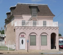 | Hotel DeFair | building | 1976 | 76001132 |
Every wildfire the federal occurrence database records inside this county: 39 of them, burning about 10,344 acres. 18 started naturally and 1 was recorded as arson. Each settlement page carries the fires within five miles of it.
| Reported cause | Fires |
|---|---|
| Natural | 18 |
| Equipment and vehicle use | 7 |
| Missing data/not specified/undetermined | 5 |
| Smoking | 4 |
| Railroad operations and maintenance | 3 |
| Debris and open burning | 1 |
| Arson/incendiarism | 1 |
The five largest, by the area the report gives. None of them was recorded as arson.
| Date | Cause | Size | Reported by | Name on the report |
|---|---|---|---|---|
| 6 April 2016 | Equipment and vehicle use | 8,000 acres | Nebraska Forest Service | not named |
| 23 April 2019 | Equipment and vehicle use | 800 acres | Nebraska Forest Service | not named |
| 23 September 2007 | Railroad operations and maintenance | 480 acres | Nebraska Forest Service | not named |
| 1 August 2012 | Natural | 300 acres | Nebraska Forest Service | not named |
| 28 August 2002 | Natural | 250 acres | Nebraska Forest Service | not named |
| 21 March 2018 | Equipment and vehicle use | 100 acres | Nebraska Forest Service | not named |
| 28 June 2017 | Natural | 100 acres | Nebraska Forest Service | not named |
| 4 July 2004 | Natural | 100 acres | Nebraska Forest Service | not named |
Every settlement page carries the fires within five miles of it - see the settlement index below.
The NOAA Storm Events Database holds 256 reports for this county, causing no deaths, 2 injuries and about $621,530 in recorded property damage. Each settlement page carries the reports that name it.
| Kind of event | Reports |
|---|---|
| Hail | 190 |
| Thunderstorm Wind | 44 |
| Tornado | 15 |
| Funnel Cloud | 4 |
| Flash Flood | 2 |
| Lightning | 1 |
The most serious of them, by death, then injury, then recorded damage. The accounts are quoted exactly as the forecast office filed them.
| When | Event | Place named | Harm | What the report says |
|---|---|---|---|---|
| June 1954 | Tornado (F1) | not stated | 1 hurt, $250,000 | no account filed |
| June 2024 | Tornado (EF3) | Whitman | 1 hurt | Emergency manager reported a tornado half mile north of Whitman. The approximate starting point of the tornado was just south of the Cherry County line, several miles north of Whitman. EF-3 damage was observed at a farm house just south of Whitman. |
| June 2000 | Hail | Hyannis | $100,000 | no account filed |
| July 2004 | Thunderstorm Wind | Hyannis | $38,000 | Numerous large trees were snapped off with a few of them falling onto parked vehicles or into buildings. An airplane hanger was destroyed, a portion of a roof was blown off a lumberyard storage shed, and 31 power poles were also broken off by the intense thunderstorm winds. |
| August 2002 | Flash Flood | Hyannis | $25,000 | A foot of water covered Highway 2 while several other roadways also had water over them. |
| June 1980 | Tornado (F1) | not stated | $25,000 | no account filed |
| May 1977 | Tornado | not stated | $25,000 | no account filed |
| July 2001 | Hail | Ashby | $15,000 | no account filed |
| September 2019 | Thunderstorm Wind | Hyannis | $14,000 | Utility company reports 14 power poles down northeast of Hyannis. Power outages reported in the area. |
| June 2016 | Thunderstorm Wind | Ashby | $10,000 | Rood damage to residence and large hay bails rolled from the wind. |
| August 2011 | Flash Flood | Hyannis | $10,000 | Driveways, county roads and hillsides had washouts and were deeply rutted as areas south of Hyannis received 4.00 inches of rain from thunderstorms. |
| May 1996 | Tornado (F0) | Hyannis | $10,000 | no account filed |
| July 2004 | Hail | Whitman | $8,000 | The large hail broke windows in homes. |
| August 2002 | Hail | Hyannis | $8,000 | Three to four inches of hail covered the ground. |
| July 2003 | Hail | Hyannis | $8,000 | no account filed |
| August 2001 | Hail | Hyannis | $8,000 | no account filed |
| July 2009 | Hail | Ashby | $7,000 | A trained storm spotter reported a windshield broken out of a pickup truck and 7 windows broken out of a home. |
| July 2009 | Hail | Hyannis | $5,000 | The large hail was combined with very strong winds. |
| June 2009 | Hail | Whitman | $5,000 | Quarter to half dollar size hail lasted 10 minutes. |
| July 2001 | Hail | Whitman | $5,000 | no account filed |
| May 2004 | Hail | Hyannis | $4,000 | no account filed |
| June 1999 | Hail | Hyannis | $4,000 | no account filed |
| June 2009 | Hail | Whitman | $3,000 | Quarter to half dollar size hail lasted about 10 minutes. |
| May 2003 | Hail | Ashby | $3,000 | Golf ball size hail accumulated on the roads up to 8 inches deep. |
| May 2003 | Hail | Ashby | $3,000 | no account filed |
| July 2003 | Hail | Hyannis | $3,000 | no account filed |
| August 2002 | Hail | Hyannis | $3,000 | no account filed |
| August 2002 | Hail | Whitman | $3,000 | no account filed |
| June 1953 | Tornado | not stated | $2,500 | no account filed |
| June 2024 | Lightning | Hyannis | $2,000 | A lightning strike killed one head of livestock at this location. |
| July 2015 | Hail | Ashby | $2,000 | Half dollar sized hail punched holes in a sky light on a home. |
| July 2003 | Hail | Hyannis | $2,000 | no account filed |
| July 2003 | Hail | Hyannis | $2,000 | no account filed |
| July 2003 | Hail | Hyannis | $2,000 | no account filed |
| July 2003 | Hail | Hyannis | $2,000 | no account filed |
| June 2002 | Hail | Hyannis | $2,000 | no account filed |
| May 2003 | Hail | Hyannis | $1,500 | no account filed |
| September 1997 | Thunderstorm Wind | Hyannis | $1,000 | Thunderstorm winds blew down several large tree branches. |
| March 2007 | Tornado (EF1) | Ashby | $500 | A supercell that produced tornadoes earlier also produced a small tornado in rural Grant County. The tornado touched down near Dubbs Ranch south of Ashby and traveled north taking down power lines, breaking off and uprooting trees along a shelter belt, broke off fenceline, and moved cattle feeding equipment around. |
| July 1981 | Tornado (F0) | not stated | $30 | no account filed |
| April 2025 | Hail | Hyannis | - | Report via social media. |
| June 2024 | Hail | Ashby | - | Time estimated by radar. |
| July 2024 | Hail | Whitman | - | Report via social media. Time estimated from radar. |
| May 2023 | Thunderstorm Wind | Hyannis | - | Public reports 70 MPH wind gusts at this location. |
| April 2022 | Thunderstorm Wind | Ashby | - | Thunderstorm wind gust estimated at 60 MPH produced some tree damage and knocked out power at this location. Some unknown size hail also fell at this location. |
| April 2022 | Thunderstorm Wind | Whitman | - | Mesonet reported a 64 MPH wind gust at this location. |
| April 2022 | Thunderstorm Wind | Whitman | - | A measured thunderstorm wind gust of 79 MPH reported at this location. |
| June 2022 | Thunderstorm Wind | Whitman | - | Thunderstorm wind gust. |
| June 2022 | Thunderstorm Wind | Hyannis | - | Thunderstorm wind gust. |
| May 2021 | Hail | Ashby | - | Delayed Report. Time estimated from radar. |
| July 2021 | Thunderstorm Wind | Ashby | - | A trained weather spotter reported several uprooted trees and windmill damage. Winds are estimated at 70 mph. |
| July 2020 | Hail | Ashby | - | A trained weather spotter reported quarter size hail near Ashby. |
| May 2018 | Thunderstorm Wind | Hyannis | - | No damage reported. |
| June 2016 | Thunderstorm Wind | Ashby | - | No significant damage reported from this wind gust. |
| June 2016 | Thunderstorm Wind | Hyannis | - | No significant damage reported from this wind gust. |
| May 2016 | Thunderstorm Wind | Hyannis | - | Thunderstorm winds were estimated at 60 MPH along with pea sized hail. |
| May 2016 | Hail | Hyannis | - | In addition to nickle sized hail, 60 MPH winds were also reported. |
| September 2016 | Thunderstorm Wind | Whitman | - | Estimated 60 mph wind gust with trees bending over and small limbs broken off. |
| July 2015 | Hail | Whitman | - | In addition to quarter sized hail, 50 MPH winds were reported. |
| July 2015 | Thunderstorm Wind | Ashby | - | Thunderstorm wind gust of 60 MPH at this location. |
Named settlements recorded in the Geographic Names Information System, each with the topographic sheets covering it. Villages, hamlets and abandoned places alike. Each is shown with the nearest named watercourse or landform and the survey quadrangle it falls on.