 Block
From the record
7 National Register listings published here.
Sources: the National Register database, National Park Service
53 topographic sheets cover 11 settlements here, and 7 properties are on the National Register of Historic Places.
7 National Register listings published here.
Sources: the National Register database, National Park Service
Every property in this county listed on the National Register of Historic Places, with the year it was listed and the federal nomination document.
| Photograph | Property | Type | Listed | Reference |
|---|---|---|---|---|
 | Bethphage Mission | district | 2013 | 13000199 |
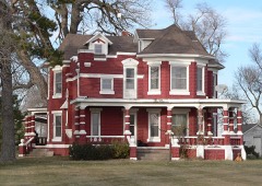 | Eddie Eugene and Harriet Cotton Carpenter Farmstead | district | 1993 | 93000059 |
 | Fort Kearney | district | 1971 | 71000485 |
 | Kearney County Courthouse | district | 1990 | 89002234 |
 | Salem Swedish Methodist Episcopal Church | building | 1982 | 82003192 |
 | W. T. Thorne Building | building | 1985 | 85002139 |
 | US Post Office-Minden | building | 1992 | 92000471 |
Every wildfire the federal occurrence database records inside this county: 82 of them, burning about 997 acres. 2 started naturally and 1 was recorded as arson. Each settlement page carries the fires within five miles of it.
| Reported cause | Fires |
|---|---|
| Debris and open burning | 31 |
| Equipment and vehicle use | 28 |
| Missing data/not specified/undetermined | 11 |
| Power generation/transmission/distribution | 4 |
| Smoking | 3 |
| Natural | 2 |
| Firearms and explosives use | 1 |
| Arson/incendiarism | 1 |
| Fireworks | 1 |
The five largest, by the area the report gives. None of them was recorded as arson.
| Date | Cause | Size | Reported by | Name on the report |
|---|---|---|---|---|
| 13 November 2011 | Debris and open burning | 200 acres | Nebraska Forest Service | not named |
| 30 March 1999 | Debris and open burning | 160 acres | Rainwater Basin Wetland Management District | PRAIRIE DG |
| 11 October 1995 | Equipment and vehicle use | 120 acres | Rainwater Basin Wetland Management District | PETERSON |
| 7 October 2006 | Equipment and vehicle use | 70 acres | Nebraska Forest Service | not named |
| 6 March 2015 | Missing data/not specified/undetermined | 70 acres | Nebraska Forest Service | not named |
| 16 March 2009 | Debris and open burning | 60 acres | Nebraska Forest Service | not named |
| 17 March 2017 | Equipment and vehicle use | 40 acres | Nebraska Forest Service | not named |
| 6 February 2009 | Equipment and vehicle use | 40 acres | Nebraska Forest Service | not named |
Every settlement page carries the fires within five miles of it - see the settlement index below.
The NOAA Storm Events Database holds 377 reports for this county, causing no deaths, no injuries and about $45,368,400 in recorded property damage. Each settlement page carries the reports that name it.
| Kind of event | Reports |
|---|---|
| Hail | 178 |
| Thunderstorm Wind | 149 |
| Tornado | 30 |
| Flash Flood | 7 |
| Heavy Rain | 7 |
| Flood | 4 |
| Funnel Cloud | 2 |
The most serious of them, by death, then injury, then recorded damage. The accounts are quoted exactly as the forecast office filed them.
| When | Event | Place named | Harm | What the report says |
|---|---|---|---|---|
| June 2002 | Hail | Minden | $20,000,000 | no account filed |
| June 2002 | Hail | Minden | $5,000,000 | no account filed |
| June 2022 | Thunderstorm Wind | Newark | $3,000,000 | Wind gusts peaked around 100 MPH along this path, with the most significant damage occurring approximately one mile east of Minden to two miles north-northeast of Minden. Numerous irrigation pivots were flipped and large tree limbs were downed. Along with multiple power poles being snapped, three large metal transmission towers were also downed. A metal outbuilding lost a portion of its roof. Significant crop damage was reported in this whole area. |
| May 2005 | Flash Flood | Countywide | $3,000,000 | no account filed |
| June 2014 | Thunderstorm Wind | Wilcox | $2,500,000 | Wind gusts estimated to reach near 80 MPH at times moved through the county, resulting in numerous overturned irrigation pivots and downed trees. |
| March 1990 | Tornado (F3) | not stated | $2,500,000 | no account filed |
| July 2014 | Thunderstorm Wind | Norman | $1,000,000 | no account filed |
| July 2024 | Tornado (EF1) | Norman | $750,000 | A small tornado touched down near a farmstead northwest of Norman and caused large tree limbs to fall onto a house. The tornado continued southeast where it snapped four power poles along K Road, overturned pivots, and carried a small brain bin over 500 yards from its original location. The tornado continued southeast and produced a few locations of minor damage before lifting prior to crossing 42 Road southeast of Norman. The peak wind gust was estimated to be 100 MPH. |
| July 2024 | Tornado (EF1) | Minden | $500,000 | This tornado touched down in the area of the golf course, then moved southeast through the northeast part of town, just south of the airport. The ground circulation was likely small and somewhat disorganized at this stage, as most of the damage in town was to trees. The tornado grew in intensity on the northeast outskirts of town, where a couple metal buildings sustained roof and overhead door damage. The tornado appeared to track along the highway northeast of town before crossing into a corn field and overturning pivots. Based on storm chaser video, this is where the condensation funnel was largest and most obvious. The end of the track between 33 Road and 34 Road was confirmed by drone video submitted to the NWS. The estimated peak wind gust of 90 MPH and EF1 rating is based on the tree damage at the golf course and the damage to the metal buildings on the edge of town. The tornado width of 200 yards is estimated based on observed damage and storm chaser video. Extensive tree damage was noted further south across Minden, and appears to be the result of an intense rear flank downdraft surge of straight-line wind. |
| December 2021 | Tornado (EF0) | Newark | $400,000 | This tornado started in Kearney County north of Minden and crossed into Buffalo County, lifting near Gibbon. This tornado was typical for the day, likely intermittent with regard to ground circulation and impacting rural areas. Much of the path damage can be traced to center irrigation pivots either partially or fully overturned. The tornado damaged a couple power poles and peeled back some roofing material at the Rowe Sanctuary. A measured wind gust 83 MPH was recorded at the sanctuary as the storm passed. Damage was a bit sparse north of the river. The tornadic circulation likely crossed Interstate 80 about three miles west of the Gibbon interchange before knocking over a couple more pivots and lifting just southwest of Gibbon. The maximum estimated speed of 85 MPH was based upon the measured wind gust at the sanctuary and damage to nearby power poles. |
| May 2024 | Tornado (EF0) | Minden | $350,000 | This EF0 rated tornado damaged a handful of irrigation pivots and trees along its over eight mile path. The peak wind speed was estimated to be 85 MPH, based upon tree damage near the middle of the path. This tornado was also noted by a drop in the WSR-88D correlation coefficient product. The drop coincides with the path, but damage was very limited. One possible theory is the lower correlation coefficient shown on radar was caused by corn stalks lifted into the air from several no-till fields. |
| April 2024 | Thunderstorm Wind | Minden | $250,000 | Report via broadcast media of tree damage across Minden, with some large limbed downed. Power line and pivot damage was reported just northeast of town. |
| June 2024 | Hail | Minden | $250,000 | Hail ranging in size from quarters up to two inches in diameter was reported along and within a few miles on each side of this path. |
| July 2024 | Thunderstorm Wind | Minden | $250,000 | Wind gusts estimated to be as high as 80 MPH resulted in widespread tree damage across the southern half of Minden. Small and large tree limbs were snapped, tree trunks were snapped, and a few trees were uprooted. |
| April 2012 | Hail | Heartwell | $250,000 | no account filed |
| April 2012 | Hail | Heartwell | $250,000 | no account filed |
| June 2000 | Flash Flood | Countywide | $250,000 | no account filed |
| March 1990 | Tornado (F2) | not stated | $250,000 | no account filed |
| July 1989 | Tornado (F0) | not stated | $250,000 | no account filed |
| April 1986 | Tornado (F2) | not stated | $250,000 | no account filed |
| October 2023 | Tornado (EF1) | Minden | $225,000 | This tornado was the strongest and longest of the day, touching down in Franklin County and crossing into Kearney County. This EF1 rated tornado with estimated peak winds of 90 MPH was on the ground for just over six miles and for about 10 minutes. Early on, the damage path was primarily found via corn stalks in fence and power|lines. Eventually the tornado overturned two pivots before reaching a farmstead near Highway 10 about eight miles south of Minden. Most structural damage was at the farmstead, including part of garage wall pushed from its foundation, damage to windows and trees and the top torn from a grain bin. The tornado crossed|the highway and gradually dissipated. The EF1 rating and subsequent 90 MPH wind speed estimate was based upon the damage to the garage, grain bin and tree damage at the farmstead. |
| December 2016 | Thunderstorm Wind | Norman | $225,000 | An old outbuilding had collapsed walls. Nine sections of center pivot were blown over and tin from outbuildings was wrapped around trees. |
| June 2020 | Thunderstorm Wind | Newark | $200,000 | Wind gusts estimated to be near 75 MPH damaged a grain bin and a shed. Several trees were damaged and 2 pivots were overturned. |
| June 2024 | Hail | Norman | $200,000 | no account filed |
| June 1999 | Thunderstorm Wind | Wilcox | $200,000 | no account filed |
| August 1997 | Thunderstorm Wind | Minden | $150,000 | no account filed |
| July 2024 | Thunderstorm Wind | Axtell | $125,000 | Peak wind gusts were estimated to be around 75 MPH, with one measured gust of 66 MPH from a mesonet station located two miles southwest of Axtell. These wind gusts caused widespread tree damage in Axtell, with several large branches downed and some trees split in two. One portion of a split tree landed on a garage. Another home suffered minor damage as well as fence damage. |
| March 2020 | Hail | Axtell | $125,000 | Hail was mostly pea to nickel sized, with a few quarter size stones, and was 2 inches deep in the yard. |
| July 2024 | Hail | Axtell | $125,000 | no account filed |
| May 2018 | Thunderstorm Wind | Norman | $125,000 | no account filed |
| December 2021 | Tornado (EF0) | Lowell | $100,000 | This shorter path tornado started east of Lowell in Kearney County and traveled north-northeast across the Platte River into Buffalo County. Damage was sparse, but a few center irrigation pivots and minor tree damage was found. The tornadic circulation likely crossed Interstate 80 about 2.5 miles west of the Shelton interchange. The tornado moved across one farmstead where a garage was completely destroyed. Minor tree damage was also noted. The damage to the garage was the primary basis for the 80 MPH maximum wind speed estimate. The tornado tipped one more pivot before lifting just northeast of the farmstead. |
| December 2016 | Thunderstorm Wind | Norman | $100,000 | Large tree limbs were blown down, along with some overturned pivots. |
| July 2014 | Hail | Heartwell | $100,000 | Hail covered the ground in a number of spots, but was discovered a time after it had fallen, so it was likely larger when it fell. There was extensive crop damage in the area. |
| June 2022 | Hail | Heartwell | $100,000 | no account filed |
| July 2019 | Flash Flood | Wilcox | $100,000 | no account filed |
| May 2005 | Hail | Minden | $100,000 | no account filed |
| June 2002 | Thunderstorm Wind | Wilcox | $100,000 | no account filed |
| June 2002 | Thunderstorm Wind | Axtell | $100,000 | no account filed |
| June 1999 | Thunderstorm Wind | Minden | $100,000 | no account filed |
| June 1999 | Thunderstorm Wind | Norman | $100,000 | no account filed |
| May 2024 | Tornado (EF0) | Axtell | $75,000 | A local resident reported damage to an irrigation pivot and soybean field north of Axtell. Subsequent radar review showed a circulation in the same area and time as the report, supporting a tornado. The location of the path was estimated based upon radar and the local resident report. The tornado was rated an EF0 with peak winds estimated to be 80 MPH based upon damage described to the pivot. |
| July 2016 | Thunderstorm Wind | Axtell | $50,000 | Wind gusts estimated to be between 60 and 70 MPH downed a large tree in town. This tree landed on a home, punching a hole through the bedroom ceiling. The tree also landed on power lines. |
| June 2018 | Hail | Axtell | $50,000 | no account filed |
| June 2018 | Hail | Axtell | $50,000 | no account filed |
| June 2018 | Hail | Minden | $50,000 | no account filed |
| May 2018 | Thunderstorm Wind | Norman | $50,000 | no account filed |
| May 2016 | Thunderstorm Wind | Norman | $50,000 | no account filed |
| July 2002 | Hail | Heartwell | $50,000 | no account filed |
| May 1999 | Tornado (F0) | Heartwell | $50,000 | no account filed |
| May 1998 | Hail | Heartwell | $50,000 | no account filed |
| June 2022 | Thunderstorm Wind | Axtell | $35,000 | A wind gust of 79 MPH was measured by a mesonet station located five miles north of Axtell. Reports via social media included large tree limbs downed, a garage severely damaged, and a flipped trampoline. |
| March 2006 | Hail | Norman | $30,000 | no account filed |
| June 2006 | Hail | Axtell | $30,000 | no account filed |
| June 2000 | Hail | Minden | $30,000 | no account filed |
| August 2014 | Thunderstorm Wind | Newark | $25,000 | Wind gusts were estimated to be near 70 MPH. Multiple tree branches were downed, some as large as 6 inches in diameter. A small fruit tree was also uprooted. |
| July 2011 | Thunderstorm Wind | Axtell | $25,000 | Wind gusts were estimated at 60 MPH and were accompanied by dime size hail. |
| May 2008 | Flash Flood | Newark | $25,000 | Thunderstorms rolled across the same area of northern Kearney County during the evening hours and dumped several inches of rain. This caused many roads and small creeks to quickly flood. |
| May 2018 | Thunderstorm Wind | Axtell | $25,000 | no account filed |
| September 2015 | Hail | Heartwell | $25,000 | no account filed |
| June 2010 | Flash Flood | Lowell | $25,000 | no account filed |
Named settlements recorded in the Geographic Names Information System, each with the topographic sheets covering it. Villages, hamlets and abandoned places alike. Each is shown with the nearest named watercourse or landform and the survey quadrangle it falls on.
District 2 · 68847 · On Crooked Creek · Kearney quadrangle
20 sheets, 1894 to 1985
No longer a settlement
District 1 · 68840 · Gibbon South quadrangle
16 sheets, 1894 to 1985
No longer a settlement
The vanished settlements of Kearney County: the places named above that are no longer on the map.