 Block
From the record
3 National Register listings published here.
Sources: the National Register database, National Park Service
31 topographic sheets cover 7 settlements here, and 3 properties are on the National Register of Historic Places.
3 National Register listings published here.
Sources: the National Register database, National Park Service
Every property in this county listed on the National Register of Historic Places, with the year it was listed and the federal nomination document.
| Photograph | Property | Type | Listed | Reference |
|---|---|---|---|---|
 | Evangelical United Brethren Church | building | 2013 | 13000678 |
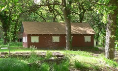 | Moses Merrill Baptist Camp | district | 2004 | 04000295 |
 | U.S. Indian Industrial School | building | 1978 | 78001706 |
Every wildfire the federal occurrence database records inside this county: 34 of them, burning about 252 acres. None started naturally and none was recorded as arson. Each settlement page carries the fires within five miles of it.
| Reported cause | Fires |
|---|---|
| Debris and open burning | 14 |
| Railroad operations and maintenance | 8 |
| Missing data/not specified/undetermined | 7 |
| Equipment and vehicle use | 4 |
| Fireworks | 1 |
The five largest, by the area the report gives. None of them was recorded as arson.
| Date | Cause | Size | Reported by | Name on the report |
|---|---|---|---|---|
| 12 February 2017 | Debris and open burning | 90 acres | Nebraska Forest Service | not named |
| 18 October 2018 | Equipment and vehicle use | 50 acres | Nebraska Forest Service | not named |
| 5 March 2000 | Debris and open burning | 30 acres | Nebraska Forest Service | not named |
| 14 March 2013 | Debris and open burning | 25 acres | Nebraska Forest Service | not named |
| 16 March 2009 | Debris and open burning | 5.0 acres | Nebraska Forest Service | not named |
| 10 March 2015 | Debris and open burning | 5.0 acres | Nebraska Forest Service | not named |
| 4 January 2004 | Debris and open burning | 5.0 acres | Nebraska Forest Service | not named |
| 7 April 2019 | Debris and open burning | 5.0 acres | Nebraska Forest Service | not named |
Every settlement page carries the fires within five miles of it - see the settlement index below.
The NOAA Storm Events Database holds 241 reports for this county, causing no deaths, no injuries and about $34,376,250 in recorded property damage. Each settlement page carries the reports that name it.
| Kind of event | Reports |
|---|---|
| Hail | 133 |
| Thunderstorm Wind | 63 |
| Tornado | 22 |
| Heavy Rain | 11 |
| Flash Flood | 8 |
| Flood | 3 |
| Funnel Cloud | 1 |
The most serious of them, by death, then injury, then recorded damage. The accounts are quoted exactly as the forecast office filed them.
| When | Event | Place named | Harm | What the report says |
|---|---|---|---|---|
| March 2019 | Flood | Genoa | $12,000,000 | no account filed |
| March 2019 | Flash Flood | Belgrade | $12,000,000 | no account filed |
| March 1990 | Tornado (F2) | not stated | $2,500,000 | no account filed |
| August 2022 | Hail | Genoa | $1,000,000 | Most hail in and north of Genoa ranged in size from quarters to golf balls, but some hail reached the size of baseballs. |
| May 2005 | Flash Flood | Countywide | $1,000,000 | no account filed |
| June 2024 | Thunderstorm Wind | Belgrade | $750,000 | Wind gusts estimated to be near 80 MPH resulted in a long swath of damage in Greeley and Nance counties. Report from social media noted this swath was approximately 6 to 8 miles wide. Widespread tree damage was reported, including large limbs downed and trunks split, as well as several flipped irrigation pivots. The combination of wind and hail caused widespread crop damage in the area. |
| June 2024 | Flash Flood | Genoa | $600,000 | Based on radar estimation and various measured totals from NWS/NeRAIN/CoCoRaHS observers, widespread rainfall of 2.50-7.00 inches fell across most of the county mainly between 8 p.m. CDT on the 21st and 1 a.m. CDT on the 22nd. Per media reports, the county supervisor reported flood damage to numerous rural roads. |
| May 2023 | Thunderstorm Wind | Fullerton | $500,000 | Wind gusts estimated to be near 70 MPH resulted in flipped irrigation pivots in eastern Nance County. |
| June 2017 | Thunderstorm Wind | Genoa | $500,000 | A several block wide stretch of wind damage occurred in Genoa, including several trees down and homes, buildings and vehicles damaged. Local businesses lost power into the following day, and a lumberyard lost a portion of the front of its building, which also sustained electrical damage. The storm also lifted off a section of the post office roof and destroyed a window. |
| May 2004 | Hail | Genoa | $250,000 | The cooperative observer in Genoa reported hail and high winds stripped trees throughout town. |
| June 1992 | Tornado (F1) | not stated | $250,000 | no account filed |
| June 1975 | Tornado (F3) | not stated | $250,000 | no account filed |
| June 2022 | Hail | Genoa | $200,000 | Hail up to the size of golf balls was accompanied by wind gusts estimated to be at least 60 MPH. |
| June 2022 | Thunderstorm Wind | Genoa | $200,000 | Wind gusts estimated to be at least 60 MPH were accompanied by hail up to the size of golf balls. |
| June 2022 | Hail | Genoa | $200,000 | An NeRAIN observer noted hail up to the size of ping pong balls and that there was tree and building damage. |
| May 2000 | Thunderstorm Wind | Fullerton | $150,000 | no account filed |
| October 2000 | Tornado (F1) | Fullerton | $125,000 | no account filed |
| June 2021 | Thunderstorm Wind | Genoa | $100,000 | Wind gusts were estimated to be around 70 MPH in Genoa, closer to 60 MPH three miles north of Genoa. Tree damage and nickel size hail was reported across Genoa. |
| June 2014 | Thunderstorm Wind | Fullerton | $100,000 | Several trees, including one 18 inches in diameter, were damaged and a roof was blown off of a building in the Fullerton. Tree damage was also reported in the Belgrade area. |
| October 2001 | Tornado (F1) | Fullerton | $75,000 | Tornado entered Nance County from Merrick County. |
| May 2012 | Hail | Fullerton | $75,000 | no account filed |
| May 2012 | Hail | Genoa | $75,000 | no account filed |
| May 2012 | Hail | Genoa | $75,000 | no account filed |
| June 1999 | Thunderstorm Wind | Fullerton | $75,000 | no account filed |
| July 2011 | Thunderstorm Wind | Fullerton | $50,000 | Wind gusts were estimated between 50 and 60 MPH in the Fullerton area. Tree damage was reported in Fullerton, with 1 vehicle damaged when tree limbs were blown down. |
| May 2008 | Flash Flood | Fullerton | $50,000 | Thunderstorms rolled across southeast Nance County during the evening and nighttime hours and dumped several inches of rain. This caused roads and small creeks to quickly flood. |
| June 2003 | Hail | Fullerton | $50,000 | A narrow swath of crop damage from southwest of Fullerton to south of Fullerton produced widespread corn and soybean damage. |
| October 2001 | Tornado (F0) | North Star | $50,000 | Tornado entered Nance County from Greeley County. The tornado then exited Nance County and entered Boone County. |
| May 2025 | Hail | Fullerton | $50,000 | no account filed |
| June 2014 | Hail | Fullerton | $50,000 | no account filed |
| July 2002 | Hail | Genoa | $50,000 | no account filed |
| August 1999 | Thunderstorm Wind | Genoa | $50,000 | no account filed |
| July 1997 | Hail | Fullerton | $50,000 | no account filed |
| May 2001 | Hail | Fullerton | $40,000 | no account filed |
| June 1997 | Hail | Fullerton | $40,000 | no account filed |
| June 1997 | Hail | Fullerton | $40,000 | no account filed |
| May 2024 | Tornado (EF1) | Fullerton | $25,000 | This EF1 rated tornado started in extreme eastern Howard County and ended in extreme southern Nance County, with most of its time spent in Merrick County north-northeast of Palmer. There were several spots of tree damage along its roughly 7 mile path. The most significant damage was to an outbuilding and large cottonwood trees northeast of Palmer. The estimated peak wind speed of 95 MPH was estimated based upon the damage at this particular farmstead. |
| February 2012 | Thunderstorm Wind | Belgrade | $25,000 | Wind gusts estimated at 60 mph destroyed an outbuilding. |
| June 2017 | Hail | Genoa | $25,000 | no account filed |
| June 2014 | Hail | Fullerton | $25,000 | no account filed |
| May 2012 | Hail | Belgrade | $25,000 | no account filed |
| May 2012 | Hail | Belgrade | $25,000 | no account filed |
| May 2012 | Hail | Fullerton | $25,000 | no account filed |
| August 2007 | Thunderstorm Wind | Genoa | $25,000 | no account filed |
| August 2007 | Thunderstorm Wind | Fullerton | $25,000 | no account filed |
| May 2004 | Hail | Genoa | $25,000 | no account filed |
| May 2004 | Thunderstorm Wind | Fullerton | $25,000 | no account filed |
| July 2003 | Thunderstorm Wind | Fullerton | $25,000 | no account filed |
| July 2003 | Thunderstorm Wind | Fullerton | $25,000 | no account filed |
| July 2003 | Thunderstorm Wind | Genoa | $25,000 | no account filed |
| August 2002 | Hail | Genoa | $25,000 | no account filed |
| June 1990 | Tornado (F1) | not stated | $25,000 | no account filed |
| March 1990 | Tornado (F1) | not stated | $25,000 | no account filed |
| June 1969 | Tornado (F1) | not stated | $25,000 | no account filed |
| May 1964 | Tornado (F2) | not stated | $25,000 | no account filed |
| June 2008 | Flash Flood | Fullerton | $20,000 | At 720CST water from Plum Creek was running across highway 22 between Fullerton and Genoa. |
| September 2006 | Thunderstorm Wind | Fullerton | $20,000 | no account filed |
| September 2006 | Thunderstorm Wind | Fullerton | $20,000 | no account filed |
| May 2002 | Thunderstorm Wind | Fullerton | $20,000 | no account filed |
| May 2012 | Hail | Fullerton | $15,000 | no account filed |
The Survey's mineral resources record lists 1 working inside this county. It still produces. Each settlement page carries the workings within five miles of it.
| Commodity | Workings |
|---|---|
| Sand and Gravel, Industrial/Frac Sand | 1 |
| Sand and Gravel, Industrial | 1 |
The least common of them first, because a county's hundredth gravel pit says nothing its first ten did not.
| Where | Site | Commodity | Status | Recorded |
|---|---|---|---|---|
| Genoa | Sand and Gravel, Industrial/Frac Sand, Sand and Gravel, Industrial | Producer | Sand |
Named settlements recorded in the Geographic Names Information System, each with the topographic sheets covering it. Villages, hamlets and abandoned places alike. Each is shown with the nearest named watercourse or landform and the survey quadrangle it falls on.
Council Creek township · 68640 · On Plum Creek · Merchiston quadrangle
13 sheets, 1896 to 1985
South Branch township · 68623 · On North Branch Timber Creek · Belgrade NW quadrangle
13 sheets, 1899 to 1985