 Block
From the record
8 National Register listings published here.
Sources: the National Register database, National Park Service
31 topographic sheets cover 16 settlements here, and 8 properties are on the National Register of Historic Places.
8 National Register listings published here.
Sources: the National Register database, National Park Service
Every property in this county listed on the National Register of Historic Places, with the year it was listed and the federal nomination document.
| Photograph | Property | Type | Listed | Reference |
|---|---|---|---|---|
 | Wallace Warren and Lillian Genevieve Bradshaw Kendall House | building | 1993 | 93001402 |
 | Lawrence Opera House | building | 1988 | 88000933 |
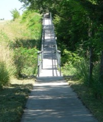 | Nelson Cemetery Walk | structure | 2002 | 02001480 |
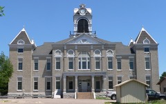 | Nuckolls County Courthouse | district | 1990 | 89002219 |
| Stewart Bridge | structure | 1992 | 92000717 | |
 | Superior City Hall and Auditorium | building | 2012 | 12000107 |
| Superior Downtown Historic District | district | 1994 | 93001405 |
Every wildfire the federal occurrence database records inside this county: 113 of them, burning about 1,818 acres. 4 started naturally and none was recorded as arson. Each settlement page carries the fires within five miles of it.
| Reported cause | Fires |
|---|---|
| Debris and open burning | 46 |
| Equipment and vehicle use | 29 |
| Missing data/not specified/undetermined | 24 |
| Power generation/transmission/distribution | 5 |
| Natural | 4 |
| Smoking | 3 |
| Fireworks | 1 |
| Recreation and ceremony | 1 |
The five largest, by the area the report gives. None of them was recorded as arson.
| Date | Cause | Size | Reported by | Name on the report |
|---|---|---|---|---|
| 8 November 2020 | Smoking | 660 acres | Nebraska Forest Service | not named |
| 5 March 2020 | Smoking | 300 acres | Kansas Forest Service | not named |
| 4 April 2002 | Debris and open burning | 198 acres | Rainwater Basin Wetland Management District | MOGER |
| 29 April 2018 | Missing data/not specified/undetermined | 100 acres | Nebraska Forest Service | not named |
| 17 May 2018 | Debris and open burning | 60 acres | Nebraska Forest Service | not named |
| 8 March 2017 | Missing data/not specified/undetermined | 55 acres | Nebraska Forest Service | not named |
| 13 April 2016 | Debris and open burning | 55 acres | Nebraska Forest Service | not named |
| 3 November 2020 | Smoking | 40 acres | Nebraska Forest Service | not named |
Every settlement page carries the fires within five miles of it - see the settlement index below.
The NOAA Storm Events Database holds 395 reports for this county, causing no deaths, 10 injuries and about $52,200,590 in recorded property damage. Each settlement page carries the reports that name it.
| Kind of event | Reports |
|---|---|
| Hail | 163 |
| Thunderstorm Wind | 132 |
| Tornado | 47 |
| Heavy Rain | 42 |
| Flash Flood | 6 |
| Lightning | 3 |
| Flood | 2 |
The most serious of them, by death, then injury, then recorded damage. The accounts are quoted exactly as the forecast office filed them.
| When | Event | Place named | Harm | What the report says |
|---|---|---|---|---|
| September 1986 | Tornado (F3) | not stated | 7 hurt, $2,500,000 | no account filed |
| March 1990 | Tornado (F4) | not stated | 3 hurt, $25,000,000 | no account filed |
| August 2025 | Thunderstorm Wind | Superior | $5,000,000 | A swath of wind with gusts estimated to be as high as 90 MPH swept through the southeastern portion of Nuckolls County. Peak measured gusts included the following: 73 MPH, measured by a mesonet station located one mile west-northwest of Ruskin; 67 MPH, measured by a mesonet station located in Ruskin; 66 MPH, measured by a mesonet station located two miles north-northwest of Superior. Widespread damage was reported along and near this path, including the Superior and Ruskin areas. An estimate of 200 trees were damaged in Superior, causing the park to be closed for a period of time for clean-up. Several roofs sustained damage in Superior, with at least two downtown businesses suffering extensive roof damage, causing damage to the interior of the businesses as well. Several downtown businesses sustained broken windows. In Ruskin in addition to tree and roof damage, the wooden pole which held the community's siren was snapped and blown onto a nearby business. There was widespread crop damage in the area. The local public power company estimated that over 200 poles and 10 miles of line had been damaged or destroyed across the area, much of which occurred across Nuckolls County, and that mutual aid had to be called into assist with restoration efforts. |
| June 2017 | Thunderstorm Wind | Superior | $3,000,000 | Wind gusts were estimated to around 75 MPH. Tree limbs of 6 to 10 inches in diameter were downed, and several streets closed due to trees across them. Power was out for much of the town for several hours. A couple vehicles were damaged by falling tree limbs. A 40 foot section of a roof was blown off of the local lumberyard and an awning was damaged at another business. At least 9 irrigation pivots were damaged south of town. Most of the damage focused between 8th Street and the Republican River. |
| May 1974 | Tornado (F2) | not stated | $2,500,000 | no account filed |
| May 2015 | Tornado (EF2) | Hardy | $1,500,000 | This is a continuation of the tornado that touched down west-northwest of Webber in Jewell County, KS, traveling northeast through the very northwest corner of Republic County, KS, before entering Nebraska near the town of Hardy in Nuckolls County. It continued traveling northeast into Thayer County, lifting northwest of Deshler. This tornado was rated an EF2, with an estimated peak wind speed of 122 MPH. EF2 damage was noted in both Jewell County, KS and Nuckolls County, NE.||Damage along this tornado path included numerous pivots overturned and snapped power poles. There was a large amount of tree damage noted. In addition, in Nuckolls County, grain bins and outbuildings were destroyed. One home sustained chimney and siding damage, while another home lost a large section of its roof. |
| June 2001 | Thunderstorm Wind | Lawrence | $1,400,000 | no account filed |
| May 2025 | Thunderstorm Wind | Angus | $1,000,000 | Wind gusts estimated to be near 75 MPH resulted in 11 empty train cars being pushed off of the track. |
| June 2014 | Thunderstorm Wind | Nelson | $1,000,000 | A line of thunderstorms with damaging wind gusts up to 80 MPH moved across the county. In Nelson, trees were reported down, including one that fell on a house and pickup, causing extensive damage to the house. At the fairgrounds, a tin roof was removed from a barn, and a couple its trusses were damaged. The roof of the arena was damaged and a camper was flipped on it side. |
| June 2017 | Hail | Superior | $1,000,000 | no account filed |
| May 2025 | Thunderstorm Wind | Angus | $500,000 | Wind gusts estimated to be near 70 MPH resulted in a few overturned irrigation pivots in the area. |
| June 2022 | Tornado (EF0) | Ruskin | $500,000 | This tornado touched down in Nuckolls County, just northwest of Ruskin, and moved southeast across town. In town, most of the damage was confined to trees. After passing through town, the tornado destroyed a shed and two empty grain bins south of town. As the tornado rapidly traveled southeast, it upset roughly a half-dozen irrigation pivots, damaged at least two more grain bins, peeled tin and shingles from the rooftops of at least two buildings, and damaged trees. After nearly 10 miles, the tornado lifted three miles north of Byron in Thayer County. |
| May 2015 | Flash Flood | Hardy | $500,000 | A swath of 5 to 9 inches of rain, with locally higher amounts, was reported primarily across the southeastern half of the county. The Republican River along the southern edge of the county was flooded. Numerous bridges and many miles of county roads were damaged by the flooding. |
| June 2014 | Thunderstorm Wind | Superior | $500,000 | A line of thunderstorms with damaging wind gusts up to 80 MPH moved across the county. Damage reported in Superior included windows being blown out and transformers downed. |
| May 2012 | Thunderstorm Wind | Hardy | $500,000 | Wind gusts estimated to be near 75 mph resulted in a swath of damage from Hardy to Ruskin. At least 4 irrigation pivots were overturned, at least 8 to 10 power poles were damaged or destroyed, and tree limbs as much as 6 to 8 inches in diameter were blown down along this path. In Hardy, a hybrid seed distribution business suffered damage to seed storage tanks. |
| August 2020 | Hail | Nelson | $300,000 | Hail ranging in size from quarters to tennis balls was reported in and around Nelson. |
| July 2011 | Thunderstorm Wind | Superior Arpt | $300,000 | Wind gusts were estimated to reach as high as 80 MPH for an extended period of time near Superior and south to the Nebraska and Kansas state line. There were reports of widespread minor to extensive tree and crop damage around the area, with a few tree limbs even landing on vehicles and homes in Superior. At least 4 to 5 area outbuildings and sheds were damaged or destroyed, as well as a couple of grain bins, and 2 irrigation pivots were overturned. |
| May 2023 | Hail | Angus | $250,000 | Hail up to the size of tennis balls was reported along Highway 4 west of Davenport. |
| May 2015 | Tornado (EF1) | Bostwick | $250,000 | This tornado touched down between Bostwick and Superior, and was rated an EF1 with an estimated peak wind speed of 100 MPH. Trees were damaged, pivots were overturned and power poles were snapped. A home northwest of Superior sustained porch damage. |
| August 2023 | Hail | Abdal | $250,000 | no account filed |
| April 2005 | Hail | Ruskin | $250,000 | no account filed |
| April 1991 | Tornado (F2) | not stated | $250,000 | no account filed |
| June 1990 | Tornado (F1) | not stated | $250,000 | no account filed |
| June 1964 | Tornado (F1) | not stated | $250,000 | no account filed |
| June 1960 | Tornado (F1) | not stated | $250,000 | no account filed |
| June 2022 | Thunderstorm Wind | Nelson | $200,000 | Wind gusts estimated to be near 65 MPH resulted in tree damage in the area. A couple of grain bins and pieces of farm equipment were damaged. |
| April 2016 | Flash Flood | Ruskin | $150,000 | Flash flooding struck western Thayer and eastern Nuckolls County on this Tuesday evening/night, thanks to a fairly narrow, north-south oriented swath of at least 4-6 inches of rain. The greatest flooding impacts occurred in the community of Deshler, as both the Spring Creek and Snake Creek flooded, along with general street flooding. The fire chief evacuated approximately 45 residents from a local nursing and assisted living home. A few residents on the south side of town on 4th Street were also evacuated. A person was trapped south of Snake Creek Bridge on 4th Street, due to the quickly rising water. Flooding also closed Highway 136 between Deshler and Ruskin for several hours, as storm chaser video depicted a roughly 200-yard stretch of water rushing across the highway three miles west of Deshler around 7:45 p.m. CDT. In addition to Highway 136, a number of rural county roads were covered with water due to flooding from nearby Spring Creek. Although general flooding of mainly low-lying areas persisted into the day of Wednesday the 27th, the worst of the more serious flash flooding eased during the pre-dawn hours. |
| May 2025 | Flash Flood | Abdal | $100,000 | Strong thunderstorms dropped as much as 4 to 6 inches of heavy rain across the area. Rural roads in the area were affected by running water, as were a portion of Highway 78/128 near the border of Webster County, NE and Jewell County, KS and a portion of Highway 281 in Smith County, KS. Some of the highest measured rain totals included: 5.62 inches from nine miles north-northwest of Burr Oak, KS; 5.61 inches from three miles east of Guide Rock, NE; 5.60 inches from six miles north of Esbon; 4.84 inches from four miles north-northwest of Bostwick. |
| May 2004 | Tornado (F1) | Ruskin | $100,000 | A tornado south of Ruskin destroyed 5 grain bins and broke several power poles. The damage was strewn over about 2 miles. |
| August 2020 | Hail | Lawrence | $100,000 | no account filed |
| August 1996 | Lightning | Nelson | $100,000 | no account filed |
| July 1996 | Lightning | Superior | $80,000 | no account filed |
| May 2019 | Tornado (EF0) | Superior | $75,000 | A brief tornado touched down in the center of Superior and severely damaged a detached garage. Shingle and gutter damage was also noted at the adjacent house. Fence and tree damage was common in the neighborhood. This tornado had an estimated maximum wind speed of 81 MPH. |
| August 2007 | Thunderstorm Wind | Superior | $75,000 | Six inch diameter limbs down in the city park. |
| July 2023 | Hail | Nora | $75,000 | no account filed |
| June 2017 | Hail | Lawrence | $75,000 | no account filed |
| May 2006 | Thunderstorm Wind | Nelson | $75,000 | no account filed |
| June 1998 | Hail | Nelson | $75,000 | no account filed |
| June 1998 | Thunderstorm Wind | Superior | $75,000 | no account filed |
| July 1997 | Thunderstorm Wind | Nelson | $75,000 | no account filed |
| April 2016 | Hail | Superior | $50,000 | Several reports of ping pong ball to golf ball size hail from Superior to 3 miles east of town, including social media photos. |
| August 2014 | Thunderstorm Wind | Superior | $50,000 | Wind gusts over a 30 minute period were estimated to be between 60 and 70 MPH. |
| September 2012 | Thunderstorm Wind | Superior | $50,000 | Wind gusts estimated at 65 mph caused roof damage to a two story apartment building in the downtown area. |
| May 2011 | Thunderstorm Wind | Superior | $50,000 | Wind gusts were estimated at 70 MPH in Superior, with 6 inch tree limbs and small outbuildings damaged 3.5 miles east of town. |
| May 2008 | Flash Flood | St Stephens | $50,000 | Thunderstorms moved northeast out of northern Kansas and into southern Nebraska and dumped several inches of rain in southern Nuckolls County during the nighttime hours. This caused several roads and small creeks to become flooded. |
| April 2001 | Tornado (F0) | Superior | $50,000 | Another brief tornado reported by the Nuckolls County Sheriff's Department. |
| July 2023 | Hail | Nora | $50,000 | no account filed |
| August 2023 | Hail | Lawrence | $50,000 | no account filed |
| August 2023 | Hail | Lawrence | $50,000 | no account filed |
| August 2023 | Hail | Abdal | $50,000 | no account filed |
| August 2021 | Hail | Lawrence | $50,000 | no account filed |
| May 2002 | Thunderstorm Wind | Lawrence | $50,000 | no account filed |
| May 2002 | Thunderstorm Wind | Lawrence | $50,000 | no account filed |
| May 1999 | Thunderstorm Wind | Nelson | $50,000 | no account filed |
| May 2004 | Tornado (F0) | Nelson | $45,000 | A tornado set down south of Deweese and hit one farmstead on its 2 mile path. A shed and grain bin were damaged. Power poles were broken in the small tornadoes path. |
| July 2005 | Thunderstorm Wind | Ruskin | $40,000 | High winds from a severe thunderstorm knocked over or caused damage to about 20 tombstones at the Spring Creek Cemetery south of Ruskin. Several large trees were damaged or completely blown over. |
| April 2001 | Tornado (F1) | Mt Clare | $40,000 | Tornado stayed mainly in open country |
| June 1997 | Lightning | Lawrence | $35,000 | no account filed |
| May 1998 | Thunderstorm Wind | Lawrence | $30,000 | no account filed |
| May 2024 | Tornado (EF0) | Lawrence | $25,000 | This tornado danced its way along an approximately six mile path in rural eastern Webster County and ended in far western Nuckolls County. It started just west of Highway 78 between 5-6 miles north of Guide Rock. The worst damage along its path occurred at a nearby farmstead, where there was widespread tree damage and minor damage to the home. The tornado crossed the highway and sporadically damaged some trees for the next couple of miles. The tornado eventually grazed another farmstead and damaged a couple areas of cedar trees. A local resident noted fence damage and debris in a fence north of the farmstead. The tornado likely ended at or near a farmstead in far western Nuckolls County where some tree damage and outbuilding damage occurred. The estimated peak wind was 85 MPH. |
Named settlements recorded in the Geographic Names Information System, each with the topographic sheets covering it. Villages, hamlets and abandoned places alike. Each is shown with the nearest named watercourse or landform and the survey quadrangle it falls on.
Beaver precinct · 68978 · On Cottonwood Creek · Bostwick quadrangle
11 sheets, 1898 to 1985
The vanished settlements of Nuckolls County: the places named above that are no longer on the map.