 Block
From the record
12 National Register listings published here.
Sources: the National Register database, National Park Service
18 topographic sheets cover 12 settlements here, and 12 properties are on the National Register of Historic Places.
12 National Register listings published here.
Sources: the National Register database, National Park Service
Every property in this county listed on the National Register of Historic Places, with the year it was listed and the federal nomination document.
| Photograph | Property | Type | Listed | Reference |
|---|---|---|---|---|
| Cincinnati Bridge | structure | 92000719 | ||
 | E. F. Hempstead House | building | 1982 | 82000611 |
 | Lindsley House | building | 1999 | 99000389 |
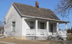 | Harold Lloyd Birthplace | building | 1993 | 93001403 |
 | Pawnee City Carnegie Library | building | 2010 | 10001004 |
| Pawnee City Historic Business District | district | 1994 | 94000066 | |
 | Pawnee County Courthouse | district | 1990 | 89002232 |
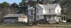 | Rinne Farm | building | 2015 | 15000089 |
 | Steinauer Opera House | building | 1988 | 88000934 |
 | Table Rock Opera House | building | 1988 | 88000931 |
| Table Rock Public Square Historic District | district | 1994 | 94000655 | |
 | US Post Office-Pawnee City | building | 1992 | 92000472 |
Every wildfire the federal occurrence database records inside this county: 64 of them, burning about 2,551 acres. None started naturally and 6 were recorded as arson. Each settlement page carries the fires within five miles of it.
| Reported cause | Fires |
|---|---|
| Debris and open burning | 44 |
| Missing data/not specified/undetermined | 8 |
| Arson/incendiarism | 6 |
| Equipment and vehicle use | 4 |
| Smoking | 2 |
The five largest, by the area the report gives. One of them was set deliberately.
| Date | Cause | Size | Reported by | Name on the report |
|---|---|---|---|---|
| 28 March 2008 | Debris and open burning | 300 acres | Nebraska Forest Service | not named |
| 3 April 2009 | Debris and open burning | 170 acres | Nebraska Forest Service | not named |
| 31 January 2009 | Missing data/not specified/undetermined | 120 acres | Nebraska Forest Service | not named |
| 9 March 2018 | Debris and open burning | 120 acres | Nebraska Forest Service | not named |
| 4 March 2018 | Debris and open burning | 120 acres | Nebraska Forest Service | not named |
| 17 April 2007 | Arson/incendiarism | 110 acres | Nebraska Forest Service | not named |
| 17 March 2009 | Missing data/not specified/undetermined | 100 acres | Nebraska Forest Service | not named |
| 2 April 2012 | Debris and open burning | 100 acres | Nebraska Forest Service | not named |
Every settlement page carries the fires within five miles of it - see the settlement index below.
The NOAA Storm Events Database holds 208 reports for this county, causing no deaths, 1 injury and about $673,000 in recorded property damage. Each settlement page carries the reports that name it.
| Kind of event | Reports |
|---|---|
| Hail | 105 |
| Thunderstorm Wind | 63 |
| Tornado | 21 |
| Flash Flood | 8 |
| Heavy Rain | 4 |
| Funnel Cloud | 3 |
| Flood | 3 |
| Lightning | 1 |
The most serious of them, by death, then injury, then recorded damage. The accounts are quoted exactly as the forecast office filed them.
| When | Event | Place named | Harm | What the report says |
|---|---|---|---|---|
| July 1958 | Tornado (F2) | not stated | 1 hurt, $250,000 | no account filed |
| May 1998 | Thunderstorm Wind | Table Rock | $150,000 | Three buildings destroyed. |
| April 2008 | Flood | Mayberry | $100,000 | Rainfall of 2 to 6 inches in a few hours time caused flooding along Turkey Creek from Johnson county into Pawnee county to near Steinauer. The flooding caused some road damage and structual damage to 1 bridge in Pawnee county. The flood waters also affected agricultural lowlands. |
| May 1996 | Lightning | Table Rock | $40,000 | no account filed |
| June 1997 | Thunderstorm Wind | Du Bois | $30,000 | Large cottonwood tree fell on house. Shed and swing set torn out and flipped over. |
| December 1975 | Tornado (F2) | not stated | $25,000 | no account filed |
| May 1974 | Tornado (F1) | not stated | $25,000 | no account filed |
| April 1968 | Tornado (F2) | not stated | $25,000 | no account filed |
| June 1998 | Thunderstorm Wind | Burchard | $5,000 | Roof blown off a barn. |
| July 1994 | Thunderstorm Wind | Burchard | $5,000 | Thunderstorm winds blew down tree limbs. |
| October 1993 | Thunderstorm Wind | Lewiston | $5,000 | Thunderstorm winds blew a shed onto a gas tank. Live electrical wires then ignited the fumes and caused a fire. |
| July 1992 | Tornado (F0) | not stated | $2,500 | no account filed |
| July 1992 | Tornado (F0) | not stated | $2,500 | no account filed |
| June 1984 | Tornado (F1) | not stated | $2,500 | no account filed |
| September 1978 | Tornado | not stated | $2,500 | no account filed |
| June 2000 | Thunderstorm Wind | Pawnee City | $2,000 | Thunderstorm wind gusts estimated at 65 mph destroyed a silo and did tree damage north of Pawnee City. |
| June 2010 | Flood | Steinauer | $1,000 | Rainfall of 3 to 5 inches caused flooding along Turkey Creek which flooded farmlands along the stream and a city pond in Pawnee City. |
| April 2026 | Hail | Mayberry | - | Public report of hail estimated up to 1 inch in diameter near Lewiston, NE. |
| April 2026 | Hail | Table Rock | - | Trained spotter report of hail measured up to 1.75 inch in diameter near Elk Creek, NE. |
| March 2025 | Thunderstorm Wind | Armour | - | Emergency manager report of a farm shop severely damaged by thunderstorm wind gusts with an estimated wind speed of 65 mph. The report was delayed, with the time estimated from radar. |
| March 2025 | Thunderstorm Wind | Table Rock | - | Trained spotter measured gust of 60 mph. |
| June 2025 | Hail | Du Bois | - | Public report of hail estimated up to 1 inch in diameter. |
| May 2025 | Hail | Mayberry | - | Public report of hail estimated up to dime size (0.75 inch) in diameter. |
| May 2025 | Tornado (EFU) | Du Bois | - | Storm chaser videos indicate that an intermittent weak tornado tracked just south of Highway 8, beginning in an open field east of Highway 50, and continuing with an intermittent ground-level circulation and dust until ending prior to reaching 631 road. The ground level dust circulation did appear to be connected to a cloud base circulation, although without a fully visible condensation funnel. No damage was noted with this tornado. |
| May 2025 | Hail | Pawnee City | - | Public report of hail estimated up to 1.25 in diameter. Report received via mPING. |
| May 2024 | Thunderstorm Wind | Lewiston | - | A 58 miles per hour wind gust was reported by a trained spotter. |
| May 2024 | Thunderstorm Wind | Steinauer | - | Fire Department measured a 60 miles per hour wind gust. This report was relayed by the Emergency Manager. |
| May 2024 | Thunderstorm Wind | Du Bois | - | Emergency Management relayed a report of doors blown off a farm outbuilding. A subsequent damage survey found this was due to straight-line winds, estimated to be at 83 miles per hour. |
| May 2024 | Hail | Pawnee City | - | Emergency Management reported quarter sized hail. |
| July 2024 | Thunderstorm Wind | Lewiston | - | A public report was received of a 59 miles per hour wind gust measured on a Davis weather instrument. |
| September 2024 | Thunderstorm Wind | Lewiston | - | A trained spotter measured a 63 miles per hour wind gust on a personal weather station. |
| May 2023 | Hail | Du Bois | - | Trained spotter reported 1-inch hail and a 35 mph wind gust. |
| July 2023 | Thunderstorm Wind | Mayberry | - | Trained spotter reported a measured peak wind gust of 68 mph. |
| July 2023 | Thunderstorm Wind | Burchard | - | A personal weather station measured a peak wind gust of 58 mph. |
| July 2023 | Thunderstorm Wind | Mayberry | - | Trained spotter reported a measured peak wind gust of 67 mph. |
| August 2023 | Thunderstorm Wind | Steinauer | - | A personal weather station measured a peak wind gust of 69 mph. |
| August 2023 | Hail | Burchard | - | Public reported 1.5-inch hail. |
| August 2023 | Hail | Burchard Rinne Arpt | - | Trained spotter reported 2-inch hail. |
| April 2023 | Hail | Du Bois | - | COOP observer reported hail slightly larger than quarters, but there weren't many of them. |
| April 2023 | Hail | Bookwater | - | Public reported 1-inch hail. |
| April 2023 | Hail | Du Bois | - | Trained spotter reported 1.5-inch hail. |
| April 2023 | Hail | Bookwater | - | Trained spotter reported 1.25-inch hail. |
| April 2023 | Hail | Du Bois | - | COOP observer reported 1-inch hail near Du Bois. |
| April 2023 | Hail | Du Bois | - | Public reported 1.25-inch hail via mPING. |
| April 2023 | Hail | Du Bois | - | Public reported 1.25-inch hail. |
| April 2023 | Hail | Lewiston | - | Trained spotter reported 1-inch hail. |
| May 2023 | Hail | Table Rock | - | Storm chaser reported 2.75-inch hail. |
| May 2023 | Hail | Table Rock | - | Public reported via mPing for 3.25-inch hail. |
| May 2023 | Tornado (EF1) | Pawnee City | - | Tornado started on the northeast side of Pawnee City where the baseball fields sustained damage. The tornado continued northeast and destroyed a grain bin and ended in a field 1 1/2 miles southwest of Table Rock. |
| May 2023 | Thunderstorm Wind | Pawnee City | - | Storm chaser reported 4-inch tree limbs blown down. |
| May 2023 | Hail | Table Rock | - | Public sent multiple photos on social media of 4.5-inch hail. |
| May 2023 | Hail | Table Rock | - | Public reported 1.25-inch hail via mPing. |
| May 2023 | Hail | Table Rock | - | Trained spotter reported 2.75-inch hail. |
| October 2022 | Thunderstorm Wind | Lewiston | - | Trained spotter reported a measured peak wind gust of 68 mph. |
| April 2022 | Funnel Cloud | Lewiston | - | A trained spotter reported a funnel cloud. |
| April 2022 | Thunderstorm Wind | Lewiston | - | Trained spotter measured a peak wind gust of 81 mph. |
| April 2022 | Hail | Lewiston | - | Trained spotter reported dime to quarter sized hail. |
| December 2021 | Thunderstorm Wind | Mayberry | - | Trained spotter reported a measured peak wind gust of 81 mph. |
| December 2021 | Thunderstorm Wind | Du Bois | - | COOP Observer reported a that a shed blew over and crushed a can. |
| July 2021 | Thunderstorm Wind | Mayberry | - | Public report from mPing of damage to 1 inch tree branches or shingles blown off. |
Named settlements recorded in the Geographic Names Information System, each with the topographic sheets covering it. Villages, hamlets and abandoned places alike. Each is shown with the nearest named watercourse or landform and the survey quadrangle it falls on.
Precinct 5, Burchard · 68323 · Liberty quadrangle
11 sheets, 1955 to 1986
No longer a settlement
Precinct 1, Pawnee No. 1 · 68345 · On Lores Branch · Du Bois quadrangle
10 sheets, 1955 to 1986
Precinct 5, Burchard · 68381 · Liberty quadrangle
11 sheets, 1955 to 1986
No longer a settlement
Precinct 1, Pawnee No. 1 · 68420 · On West Branch Turkey Creek · Pawnee City quadrangle
10 sheets, 1955 to 1986
Precinct 4, Steinauer · 68441 · On Rock Creek · Steinauer quadrangle
10 sheets, 1955 to 1986
Precinct 3, Table Rock · 68447 · On Clear Creek · Table Rock quadrangle
10 sheets, 1955 to 1986
Precinct 4, Steinauer · 68458 · Lewiston quadrangle
10 sheets, 1955 to 1986
No longer a settlement
Precinct 5, Burchard · 68420 · On Balls Branch · Burchard quadrangle
10 sheets, 1955 to 1986
No longer a settlement
The vanished settlements of Pawnee County: the places named above that are no longer on the map.