 Block
From the record
4 National Register listings published here.
Sources: the National Register database, National Park Service
22 topographic sheets cover 6 settlements here, and 4 properties are on the National Register of Historic Places.
4 National Register listings published here.
Sources: the National Register database, National Park Service
Every property in this county listed on the National Register of Historic Places, with the year it was listed and the federal nomination document.
| Photograph | Property | Type | Listed | Reference |
|---|---|---|---|---|
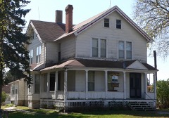 | Gov. John Hopwood Mickey House | building | 1977 | 77000835 |
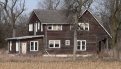 | Charles H. Morrill Homestead | building | 1973 | 73001072 |
 | Polk County Courthouse | building | 1990 | 89002238 |
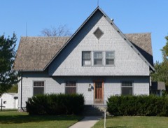 | Victor E. Wilson House | building | 1988 | 88000915 |
Every wildfire the federal occurrence database records inside this county: 124 of them, burning about 1,410 acres. 4 started naturally and 3 were recorded as arson. Each settlement page carries the fires within five miles of it.
| Reported cause | Fires |
|---|---|
| Debris and open burning | 52 |
| Equipment and vehicle use | 23 |
| Missing data/not specified/undetermined | 15 |
| Railroad operations and maintenance | 12 |
| Smoking | 8 |
| Power generation/transmission/distribution | 6 |
| Natural | 4 |
| Arson/incendiarism | 3 |
| Fireworks | 1 |
The five largest, by the area the report gives. None of them was recorded as arson.
| Date | Cause | Size | Reported by | Name on the report |
|---|---|---|---|---|
| 7 May 2011 | Smoking | 320 acres | Nebraska Forest Service | not named |
| 8 November 2009 | Debris and open burning | 160 acres | Nebraska Forest Service | not named |
| 26 January 2012 | Debris and open burning | 90 acres | Nebraska Forest Service | not named |
| 28 January 2012 | Debris and open burning | 80 acres | Nebraska Forest Service | not named |
| 3 April 2009 | Debris and open burning | 80 acres | Nebraska Forest Service | not named |
| 7 October 2011 | Equipment and vehicle use | 61 acres | Nebraska Forest Service | not named |
| 18 March 2009 | Debris and open burning | 60 acres | Nebraska Forest Service | not named |
| 12 March 2014 | Debris and open burning | 60 acres | Nebraska Forest Service | not named |
Every settlement page carries the fires within five miles of it - see the settlement index below.
The NOAA Storm Events Database holds 325 reports for this county, causing no deaths, 10 injuries and about $92,797,750 in recorded property damage. Each settlement page carries the reports that name it.
| Kind of event | Reports |
|---|---|
| Hail | 140 |
| Thunderstorm Wind | 95 |
| Tornado | 38 |
| Heavy Rain | 30 |
| Flash Flood | 12 |
| Flood | 7 |
| Funnel Cloud | 2 |
| Lightning | 1 |
The most serious of them, by death, then injury, then recorded damage. The accounts are quoted exactly as the forecast office filed them.
| When | Event | Place named | Harm | What the report says |
|---|---|---|---|---|
| July 2023 | Lightning | Shelby | 6 hurt | Six employees working on the construction of a new grain elevator on the northeastern fringe of Shelby were sent to the hospital with non-life threatening injuries when lightning struck the structure. |
| July 1968 | Tornado (F2) | not stated | 2 hurt, $250,000 | no account filed |
| June 2003 | Thunderstorm Wind | Shelby | 1 hurt, $1,000,000 | no account filed |
| July 1962 | Tornado (F3) | not stated | 1 hurt, $250,000 | no account filed |
| May 1993 | Tornado (F3) | Blue Hill to | $50,000,000 | Tornado touched down four miles south of Blue Hill in northern Webster county. Two farm homes, and outbuildings were damaged. Two 12,00 bushel grain bins were destroyed. The tornado moved north into southeast Adams county, where it damaged 75 to 100 homes in Ayr and Pauline. It then moved into southwest Clay county where it derailed 25 cars from a train between Glenvill and Fairfield. A farm house, garage and grain bins were damaged near Glenvill. It then moved north and lifted to a funnel cloud over northern Clay and southern Hamilton counties but touched down again just north of Interstate 80 where it destroyed three domes, and one church. Other homes and outbuildings were damaged. The tornado was last spotted moving into western Polk county northeast of Hordville. |
| April 1978 | Tornado | not stated | $25,000,000 | no account filed |
| June 2011 | Tornado (EF3) | Durant | $4,000,000 | The second EF3 tornado of the day touched down approximately 4 miles east of Polk and continued north for nearly 10 miles before lifting approximately 6 miles west-northwest of Osceola. Damage was noted right at the start of the path, with a brick home on Highway 66 west of Polk suffering significant roof, window and tree damage, and a semi-truck and trailer were knocked over onto its side. About 2 miles north of Highway 66, a residence suffered minor tree damage and lost an outbuilding, and a combine was tossed about 100 yards into a field. As the tornado continued north, numerous power poles were snapped, irrigation pivots were overturned, and crops were stripped from the ground. The most significant damage occurred when a farmstead on Highway 92 approximately 6 miles west of Osceola took a direct hit. The home as well as surrounding outbuildings and trees were either destroyed or suffered significant damage. A car, tractor, and an ATV were thrown from their original locations into the field just north of the home. The tornado finally lifted approximately 2 miles north of the intersection of Highways 92 and 39, but not before striking another farmstead, destroying an outbuilding and garage, and damaging a machine shed and barn. The maximum wind speed of this tornado was estimated to be 140 MPH. |
| April 1978 | Tornado | not stated | $2,500,000 | no account filed |
| October 2001 | Tornado (F3) | Polk | $1,800,000 | A strong tornado entered Polk County from Hamilton County. |
| May 2024 | Tornado (EF0) | Shelby | $1,000,000 | A brief EF0 rated tornado skirted its way across northern Polk County in the early morning hours of May 21st. The tornado damaged trees, downed power lines and poles, and overturned several irrigation pivots. The peak wind was estimated to be 80 MPH. |
| May 2019 | Flood | Osceola | $500,000 | Heavy rainfall resulted in widespread flooding across Polk County. Clear Creek, Davis Creek and the Big Blue River were all out of their banks. The Clear Creek gauge, located in rural portions of Polk County north of Shelby, crested at 8.23 feet the afternoon of the 28th, and that was the 4th-highest crest on record. Numerous rural roads and bridges were covered in water. Due to the Davis Creek flooding, water covered a portion of Highway 81/92 just outside the west side of Osceola and threatened the highway as well as homes and property on the east side of town. To keep people from driving into Osceola, Highway 81/92 was closed approximately 3 miles east of town. |
| December 2021 | Tornado (EF1) | Polk | $400,000 | This Polk County tornado touched down southeast of Polk and crossed Highway 66 about two miles east of town. The estimated maximum wind speed of 100 MPH was based upon multiple stretches of snapped power poles. Several irrigation pivots were overturned along and near its path. |
| December 2021 | Thunderstorm Wind | Shelby | $350,000 | Straight-line winds in this area were estimated to be around 85 MPH. In addition to a few irrigation pivots being overturned, a large metal-framed structure with attached canopy at an area cattle lot suffered significant damage. |
| June 2018 | Thunderstorm Wind | Shelby | $300,000 | A cooperative observer 3 miles northeast of Shelby reported 7 inch diameter tree branches down, plus several pivots around the area knocked over. |
| June 2021 | Hail | Osceola | $250,000 | Hail ranging from quarter size to two inches in diameter was reported across Osceola. |
| May 2025 | Hail | Swedehome | $250,000 | no account filed |
| April 2002 | Thunderstorm Wind | Shelby | $250,000 | no account filed |
| June 1992 | Tornado (F2) | not stated | $250,000 | no account filed |
| June 1986 | Tornado (F1) | not stated | $250,000 | no account filed |
| June 1985 | Tornado (F1) | not stated | $250,000 | no account filed |
| December 2021 | Tornado (EF1) | Hordville | $150,000 | This tornado touched down in northeast Hamilton County near Kronborg and moved northeast into southwest Polk County. This tornado was one of the more classic-looking tornadoes of the day, based on photos reviewed. The estimated maximum wind speed of 100 MPH was based primarily upon snapped power poles, but a hog facility was also heavily damages about 2 miles into the path of this tornado. The tornado crossed Highway 66 about two miles west of Polk. Just before it lifted north of Polk, the tornado took down a large metal building. |
| May 2018 | Hail | Shelby | $150,000 | Quarter to golf ball size hail was reported. |
| April 2015 | Hail | Shelby | $150,000 | In addition, a nearby NeRAIN observer reported some broken windows and roof damage in the extreme northeast Polk County area. |
| April 2024 | Thunderstorm Wind | Stromsburg | $100,000 | The roof was blown off of a building used for 190 head of cattle...unfortunately one died and a few others were injured. Other outbuildings at the farmstead suffered minor damage. Wind gusts were estimated to have been near 75 MPH. |
| June 2017 | Hail | Osceola | $100,000 | Hail ranging from quarter to golf ball size fell along the Highway 81/92 corridor between Osceola and Shelby. |
| July 2014 | Hail | Stromsburg | $100,000 | Quarter size hail was accompanied by 60 MPH winds. |
| July 2014 | Thunderstorm Wind | Stromsburg | $100,000 | Wind gusts were estimated to be near 60 MPH and accompanied quarter size hail. |
| May 2011 | Tornado (EF1) | Osceola | $100,000 | This confirmed tornado was witnessed by a number of spotters, including the Emergency Manager and Fire Chief. The initial touchdown was south of Osceola, but lifted as it approached the town. It then touched down once again on the northeast edge of town, before lifting for the final time approximately 3/4 of a mile to the north. Damage included 4 metal sheds destroyed south of town, with some of the debris ending up in the city park, a large tree uprooted in the city park, and porch and shed damage to a residence on the north side of town. The top wind speed estimated with this tornado was 90 mph. |
| July 2003 | Thunderstorm Wind | Osceola | $100,000 | no account filed |
| June 2002 | Hail | Stromsburg | $100,000 | no account filed |
| June 1998 | Hail | Stromsburg | $100,000 | no account filed |
| June 1997 | Thunderstorm Wind | Osceola | $100,000 | no account filed |
| June 2017 | Thunderstorm Wind | Swedehome | $75,000 | An unofficial wind gust of 92 MPH was measured by a mesonet site 7 miles east of Clarks. Other reports from spotters and chasers estimated wind gusts between 60 and 80 MPH in the area. Large gustnadoes were reported crossing Highway 39. |
| June 2017 | Thunderstorm Wind | Osceola | $75,000 | This was the second round of wind gusts estimated near 65 MPH to affect Osceola this night. Between the 2 rounds, numerous large tree branches were downed in town, some blocking roadways. |
| May 2016 | Flash Flood | Polk | $75,000 | Training, slow moving thunderstorms with torrential rainfall resulted in flash flooding across northern Hamilton, far southwestern Polk and far north-northwestern York Counties. Hamilton County was the hardest hit, with radar estimates of 5 to 8 inches of rain. Numerous county roads were covered with water and were closed. One home near Marquette in Hamilton County had about 2 feet of water inside and around the house. Animals at the farmstead had to be moved, and witnesses claimed the horses were nearly belly-deep in water at one point. This water moved downstream into Polk and York Counties, causing flooding along the Big Blue River. |
| October 2013 | Hail | Shelby | $75,000 | Golf ball size hail fell in the community of Shelby. |
| August 2007 | Thunderstorm Wind | Shelby | $75,000 | High winds and nickel size hail. Eight inch tree limbs broken. |
| August 2007 | Hail | Osceola | $75,000 | no account filed |
| August 2007 | Hail | Osceola | $75,000 | no account filed |
| October 2023 | Thunderstorm Wind | Osceola | $50,000 | A wind gust of 86 MPH was measured by a mesonet station located on the south side of Osceola. This anemometer was mounted approximately 30 feet up. A metal amateur radio tower approximately 40 feet tall was knocked over at this location. One of the wooden light poles at nearby high school football field was snapped. Overall minor tree damage was reported in town and power was out on the south side of town. |
| June 2021 | Hail | Osceola | $50,000 | Hail ranging from quarter size to ping pong ball size was reported along and near this path. |
| June 2020 | Thunderstorm Wind | Shelby | $50,000 | Wind gusts were estimated to be near 60 MPH in Shelby and the NWS cooperative observer 3 miles northeast of town reported downed tree branches up to 3 inches in diameter. |
| May 2008 | Flash Flood | Polk | $50,000 | Thunderstorms rolled across Polk County during the nighttime hours and dumped several inches of rain. This caused roads and small creeks to quickly flood. |
| April 2015 | Hail | Swedehome | $50,000 | no account filed |
| July 2014 | Hail | Shelby | $50,000 | no account filed |
| May 2012 | Hail | Osceola | $50,000 | no account filed |
| June 2011 | Hail | Shelby | $50,000 | no account filed |
| March 2006 | Thunderstorm Wind | Stromsburg | $50,000 | no account filed |
| April 2005 | Flash Flood | Shelby | $50,000 | no account filed |
| May 2002 | Thunderstorm Wind | Osceola | $50,000 | no account filed |
| June 2002 | Hail | Polk | $50,000 | no account filed |
| July 2002 | Hail | Shelby | $50,000 | no account filed |
| May 1999 | Hail | Osceola | $50,000 | no account filed |
| May 1998 | Thunderstorm Wind | Shelby | $50,000 | no account filed |
| May 2021 | Tornado (EF0) | Stromsburg | $45,000 | This tornado moved north-northwest across a farmstead just south of Highway 66 and then crossed the highway southwest of Stromsburg. It dissipated a little farther north of the highway. The tornado upset a horse trailer, damaged shingles on a house, and ripped off the overhead doors from a metal building. |
| June 2008 | Flash Flood | Polk | $40,000 | Southern Polk County had 4 to 7 inches of rainfall that sent water rushing across highways 92 and 81 near Osceola. Water was over the highways in all four directions out of Osceola. |
| May 2011 | Thunderstorm Wind | Swedehome | $35,000 | Wind gusts were estimated at 70 mph, causing a roof of a shed to be partially torn off, minor tree limb damage, and portion of a pivot to be overturned. |
| March 2006 | Thunderstorm Wind | Osceola | $30,000 | no account filed |
| May 2002 | Hail | Osceola | $30,000 | no account filed |
| June 1998 | Hail | Shelby | $30,000 | no account filed |
Named settlements recorded in the Geographic Names Information System, each with the topographic sheets covering it. Villages, hamlets and abandoned places alike. Each is shown with the nearest named watercourse or landform and the survey quadrangle it falls on.
West Stromsburg precinct · 68666 · On Prairie Creek · Stromsburg quadrangle
13 sheets, 1896 to 1985