 Block
From the record
8 National Register listings published here.
Sources: the National Register database, National Park Service
41 topographic sheets cover 19 settlements here, and 8 properties are on the National Register of Historic Places.
8 National Register listings published here.
Sources: the National Register database, National Park Service
Every property in this county listed on the National Register of Historic Places, with the year it was listed and the federal nomination document.
| Photograph | Property | Type | Listed | Reference |
|---|---|---|---|---|
| Colclesser Bridge | structure | 1992 | 92000729 | |
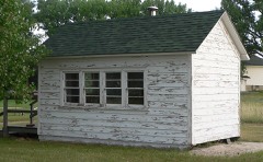 | District #119 North School | building | 2010 | 10000606 |
 | Lee and Gottliebe Fritz House | building | 2003 | 03001213 |
 | Gourley's Opera House | building | 1988 | 88000943 |
| Loosveldt Bridge | structure | 1992 | 92000730 | |
 | Sheridan County Courthouse | district | 1990 | 89002216 |
| Spade Ranch | district | 1980 | 80002464 | |
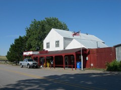 | Spade Ranch Store | building | 2010 | 10000629 |
Every wildfire the federal occurrence database records inside this county: 302 of them, burning about 18,383 acres. 115 started naturally and 4 were recorded as arson. Each settlement page carries the fires within five miles of it.
| Reported cause | Fires |
|---|---|
| Natural | 115 |
| Equipment and vehicle use | 83 |
| Debris and open burning | 39 |
| Missing data/not specified/undetermined | 26 |
| Railroad operations and maintenance | 18 |
| Power generation/transmission/distribution | 9 |
| Arson/incendiarism | 4 |
| Fireworks | 3 |
| Recreation and ceremony | 3 |
| Misuse of fire by a minor | 1 |
| Smoking | 1 |
The five largest, by the area the report gives. None of them was recorded as arson.
| Date | Cause | Size | Reported by | Name on the report |
|---|---|---|---|---|
| 16 March 2015 | Equipment and vehicle use | 2,500 acres | Nebraska Forest Service | not named |
| 5 August 2012 | Railroad operations and maintenance | 1,000 acres | Nebraska Forest Service | not named |
| 22 August 2003 | Missing data/not specified/undetermined | 1,000 acres | South Dakota Wildland Fire Suppression | not named |
| 30 March 2012 | Equipment and vehicle use | 850 acres | Nebraska Forest Service | not named |
| 25 July 2012 | Recreation and ceremony | 500 acres | Nebraska Forest Service | not named |
| 28 August 2020 | Natural | 450 acres | Nebraska Forest Service | not named |
| 20 July 2012 | Natural | 350 acres | Nebraska Forest Service | not named |
| 22 July 2012 | Natural | 350 acres | Nebraska Forest Service | not named |
Every settlement page carries the fires within five miles of it - see the settlement index below.
The NOAA Storm Events Database holds 820 reports for this county, causing no deaths, 15 injuries and about $12,058,760 in recorded property damage. Each settlement page carries the reports that name it.
| Kind of event | Reports |
|---|---|
| Hail | 546 |
| Thunderstorm Wind | 193 |
| Tornado | 62 |
| Flash Flood | 9 |
| Funnel Cloud | 7 |
| Lightning | 1 |
| Heavy Rain | 1 |
| Flood | 1 |
The most serious of them, by death, then injury, then recorded damage. The accounts are quoted exactly as the forecast office filed them.
| When | Event | Place named | Harm | What the report says |
|---|---|---|---|---|
| June 1978 | Tornado (F2) | not stated | 8 hurt, $2,500,000 | no account filed |
| August 2014 | Hail | White Clay | 4 hurt | Baseball size hail and strong winds injured 4 in Whiteclay. One person was taken to a local hospital. |
| August 2012 | Lightning | Hay Spgs | 3 hurt, $1,000,000 | Lightning ignited a wildfire on August 29th that spread quickly north across grassland and timbers across northwest Sheridan County. The wildfire burned approximate 44,159 acres in Nebraska and moved north into South Dakota. Initial assessments showed the wildfire burned approximately 100 power poles. The Rushville Sheriff requested an Evacuate Immediate (NWEM) message as the fire spread into parks and to alert homeowners and campers in the area. The fire stats showed 50 to 60 outbuildings destroyed, and approximately 10 homes damaged. The wildfire continued into September. |
| May 1993 | Tornado (F3) | Hay Springs | $5,000,000 | A tornado started approximately 12 miles south of Hay Springs and eventually ended northeast of town. One home was destroyed and three other homes were damaged as the tornado went through town. Trees were uprooted and grain bins were also destroyed. Loss of livestock included 40 lambs and 8 cattle on a farm south of town. The damage to the Northwest Rural Public Power District was estimated at $65,000. Total damage from the tornado was near $1,000,000. |
| June 1997 | Hail | Gordon | $750,000 | no account filed |
| August 1996 | Flash Flood | Rushville | $500,000 | no account filed |
| June 1997 | Hail | Gordon | $250,000 | Thunderstorm winds in excess of 60 mph damaged roofs and blew a tree over which landed on a parked vehicle in the town of Gordon. |
| June 1980 | Tornado (F1) | not stated | $250,000 | no account filed |
| April 1957 | Tornado (F2) | not stated | $250,000 | no account filed |
| June 2006 | Tornado (F1) | Rushville | $150,000 | An anti-cyclonic left-moving supercell produced a brief, weak tornado that ripped off the roof of a home, destroyed the attached two car garage, moved outbuildings, and destroyed metal cattle shields. Debris from the destroyed home impacted a large metal machine shed and was scattered along a 1 mile path northeast of the farmstead. The home was a complete loss as the chimney fell into the house breaking floor joists. |
| June 2006 | Thunderstorm Wind | Rushville | $150,000 | Outflow winds estimated at 90 mph, from an anti-cyclonic left-moving supercell that produced a weak tornado 1.5 miles south of Rushville, uprooted trees, took roofs off two buildings, toppled an old wooden grain elevator, and overturned a camper. Falling trees damaged homes, businesses, and vehicles. |
| June 2013 | Tornado (EF0) | Gordon | $100,000 | A tornado formed 5 miles south southeast of Gordon at 1731MST in a corn field. It moved southeast for a path length of three quarters of a mile where a center irrigation pivot system was damaged and crop destroyed in the path. In addition, six power poles were pulled out of the ground and a tree line damaged before dissipating at 1739MST. The tornado was rated an EF0 with an average path width of .20 yards. |
| May 2000 | Hail | Rushville | $100,000 | Extensive damage to houses and vehicles in Rushville. |
| July 2000 | Hail | Clinton | $50,000 | no account filed |
| August 1996 | Flash Flood | Sheridan | $50,000 | no account filed |
| July 2014 | Thunderstorm Wind | Antioch | $40,000 | Grain bin elevator knocked over and branches to 3 feet long downed. |
| July 2007 | Hail | Gordon | $35,000 | The large hail caused damage to roofs, vehicles and corn and wheat crops. |
| July 2004 | Hail | Hay Spgs | $35,000 | Strong winds accompanied the hail to break windows in cars and homes, cause severe body damage to vehicles, damage siding and roofs on homes, and shred corn crops in the area. |
| May 2017 | Thunderstorm Wind | White Clay | $25,000 | General public reported that a Viaero communications tower was blown down due to damaging thunderstorm winds in excess of 60 mph. The tower was located 3 miles south of White Clay, and 1 mile west of highway 87 in northern Sheridan County. |
| July 2016 | Tornado (EF2) | Clinton | $25,000 | At 1903MDT the tornado touched down in an open field and moved south. It produced damage to three rows of tree wind breaks, destroyed 75 yards of fencing, and removed shingles from a double wide mobile home. Several tree trunks were snapped with the limb debris carried southeast. Law enforcement observed the tornado. The tornado was rated an EF-1 on the Enhanced Fujita Scale with a peak wind of 107 MPH. |
| June 2015 | Hail | Antioch | $25,000 | Hail to ping pong ball size with 40 to 50 mph wind gusts broke windows on north side of house. |
| June 2006 | Hail | Hay Spgs | $25,000 | Hail driven by strong wind completely destroyed corn and wheat fields, broke windows in homes, shredded vinyl siding on a house, and damaged roofs. |
| August 1989 | Tornado (F1) | not stated | $25,000 | no account filed |
| June 1982 | Tornado (F1) | not stated | $25,000 | no account filed |
| May 1982 | Tornado (F2) | not stated | $25,000 | no account filed |
| July 1981 | Tornado (F1) | not stated | $25,000 | no account filed |
| August 1980 | Tornado (F2) | not stated | $25,000 | no account filed |
| June 1962 | Tornado (F0) | not stated | $25,000 | no account filed |
| May 1962 | Tornado (F2) | not stated | $25,000 | no account filed |
| July 1961 | Tornado (F1) | not stated | $25,000 | no account filed |
| June 2010 | Thunderstorm Wind | Gordon | $24,000 | Six power poles were downed with a total of 20 poles downed across northern Sheridan County. |
| June 2017 | Tornado (EF1) | Antioch | $21,000 | Witnesses describe a tornado touching down and destroying mainly cottonwood trees in wind breaks. The path was not continuous. The tornado lifted and then continued to the northeast, hitting a homestead, damaging old outbuildings and snapping or pushing over 30 wooden power poles. |
| June 2017 | Tornado (EF1) | Antioch | $21,000 | Witnesses describe a tornado touching down and destroying mainly cottonwood trees in wind breaks. The path was not continuous. The tornado lifted and then continued to the northeast, hitting a homestead, damaging old outbuildings and snapping or pushing over 30 wooden power poles. Same tornado / track as the other LSRs. |
| June 2017 | Tornado (EF1) | Antioch | $21,000 | Witnesses describe a tornado touching down and destroying mainly cottonwood trees in wind breaks. The path was not continuous. The tornado lifted and then continued to the northeast, hitting a homestead, damaging old outbuildings and snapping or pushing over 30 wooden power poles. Final damage point from Antioch tornado. |
| July 2024 | Thunderstorm Wind | Hay Spgs | $20,000 | Wind gusts estimated at 70 MPH blew off a roof on a shed, and downed a tree at this location. Vehicle and crop damage reported from wind and hail at this location. |
| July 2015 | Hail | Clinton | $20,000 | In addition to ping pong ball sized hail, numerous trees were blown over at this location. |
| June 2007 | Thunderstorm Wind | Gordon | $20,000 | Thunderstorm outflow winds uprooted and broke off numerous large trees, tore off part of the roof of the Local Pride packing plant, took down power lines, and damaged the siding and sign for the Ideal grocery store on the south side of Gordon. |
| August 2009 | Hail | Gordon | $15,000 | Golf ball size hail broke out all the windows on the north side of a home and caused roof damage. |
| July 2003 | Hail | Gordon | $15,000 | Hail severely damaged corn crops near the edge of Gordon. |
| June 2006 | Hail | Rushville | $15,000 | no account filed |
| June 2002 | Hail | Hay Spgs | $15,000 | no account filed |
| August 2002 | Hail | Rushville | $15,000 | no account filed |
| June 2007 | Thunderstorm Wind | Antioch | $12,000 | Several tree limbs over 4 inches brought down by thunderstorm wind gusts. |
| July 1997 | Thunderstorm Wind | Ellsworth | $12,000 | Thunderstorm winds tore off shingles on several roofs in the Ellsworth area. |
| August 2025 | Thunderstorm Wind | Ellsworth | $10,000 | Thunderstorm wind gusts, estimated at 80 MPH destroyed an outbuilding and uprooted trees at this location. |
| May 2023 | Flash Flood | Gordon | $10,000 | Trained spotter reports 3.50 inches of rainfall in Gordon with some street flooding. |
| June 2015 | Hail | Rushville | $10,000 | The fire department reported that damage occurred to siding and the roof of a house located 2 miles east southeast of Rushville. Hail size was reported as golf ball. |
| June 2015 | Hail | Clinton | $10,000 | All windows were broken out on the north side of home. |
| July 2015 | Thunderstorm Wind | Clinton | $10,000 | Large tree limbs down at this location along with nickel sized hail. |
| July 2005 | Flash Flood | White Clay | $10,000 | Over 2 inches of rain fell in 45 minutes to produce lowland flooding with at least one road washed out. |
| June 2003 | Thunderstorm Wind | Antioch | $10,000 | The winds broke off a ten inch diameter tree limb which fell on a house damaging the roof. A skylight in the house was also broken from wind blown hail. |
| June 2001 | Tornado (F0) | Gordon | $10,000 | F0 tornado broke off a few utility poles as it passed through open rangeland. |
| May 2000 | Thunderstorm Wind | Clinton | $10,000 | Garage blown over |
| May 2000 | Thunderstorm Wind | Rushville | $10,000 | Garage wall blown out and dog kennel destroyed |
| September 1999 | Thunderstorm Wind | Ellsworth | $10,000 | Several power poles were blown down. |
| August 2002 | Hail | Gordon | $10,000 | no account filed |
| August 2002 | Hail | Hay Spgs | $10,000 | no account filed |
| July 2009 | Hail | Antioch | $8,000 | The hail lasted for 10 minutes or more and was accompanied by strong winds. |
| August 2007 | Hail | Ellsworth | $8,000 | Hail of varying sizes from pea to golf ball fell east of Ellsworth and was accompanied by heavy rain that reduced visibility to less than 1000 feet. |
| June 2009 | Hail | Rushville | $8,000 | no account filed |
The Survey's mineral resources record lists 1 working inside this county. It still produces. Each settlement page carries the workings within five miles of it.
| Commodity | Workings |
|---|---|
| Sand and Gravel, Construction | 1 |
The least common of them first, because a county's hundredth gravel pit says nothing its first ten did not.
| Where | Site | Commodity | Status | Recorded |
|---|---|---|---|---|
| Stout Pit | Sand and Gravel, Construction | Producer |
Named settlements recorded in the Geographic Names Information System, each with the topographic sheets covering it. Villages, hamlets and abandoned places alike. Each is shown with the nearest named watercourse or landform and the survey quadrangle it falls on.
Hay Springs precinct · 69337 · On Little Beaver Creek · Chadron NE quadrangle
8 sheets, 1955 to 1985
No longer a settlement
Wounded Knee precinct · 69343 · Clinton NE quadrangle
8 sheets, 1955 to 1985
No longer a settlement
South Sheridan precinct · 69351 · Smith Lake quadrangle
11 sheets, 1948 to 1989
No longer a settlement
Mirage precinct · 69347 · Skunk Lake NE quadrangle
10 sheets, 1950 to 1989
No longer a settlement
South Sheridan precinct · 69340 · White Lake quadrangle
11 sheets, 1948 to 1989
No longer a settlement
South Sheridan precinct · 69301 · Skunk Lake quadrangle
10 sheets, 1950 to 1989
No longer a settlement
Mirage precinct · 69301 · Skunk Lake NW quadrangle
10 sheets, 1950 to 1989
No longer a settlement
Mirage precinct · 69347 · Hay Springs SW quadrangle
8 sheets, 1955 to 1985
No longer a settlement
North Rushville precinct · 69360 · On Craven Creek · Whiteclay quadrangle
8 sheets, 1955 to 1985
North Rushville precinct · 69365 · On Craven Creek · Whiteclay quadrangle
8 sheets, 1955 to 1985
The vanished settlements of Sheridan County: the places named above that are no longer on the map.