 Block
From the record
5 National Register listings published here, 1 of them a National Historic Landmark.
Sources: the National Register database, National Park Service
14 topographic sheets cover 6 settlements here, and 5 properties are on the National Register of Historic Places.
5 National Register listings published here, 1 of them a National Historic Landmark.
Sources: the National Register database, National Park Service
Every property in this county listed on the National Register of Historic Places, with the year it was listed and the federal nomination document.
| Photograph | Property | Type | Listed | Reference |
|---|---|---|---|---|
 | First Thurston County Courthouse | building | 1990 | 89002210 |
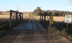 | North Omaha Creek Bridge | structure | 1992 | 92000727 |
 | Dr. Susan Picotte Memorial Hospital | building | 1988 | 88002762 |
 | Susan La Flesche Picotte House | building | 2009 | 09000905 |
 | Thurston County Courthouse | building | 1990 | 89002209 |
Every wildfire the federal occurrence database records inside this county: 790 of them, burning about 22,117 acres. 3 started naturally and 183 were recorded as arson. Each settlement page carries the fires within five miles of it.
| Reported cause | Fires |
|---|---|
| Arson/incendiarism | 183 |
| Debris and open burning | 148 |
| Missing data/not specified/undetermined | 135 |
| Smoking | 130 |
| Misuse of fire by a minor | 121 |
| Equipment and vehicle use | 26 |
| Fireworks | 26 |
| Recreation and ceremony | 14 |
| Natural | 3 |
| Power generation/transmission/distribution | 2 |
| Railroad operations and maintenance | 2 |
The five largest, by the area the report gives. Two of them were set deliberately.
| Date | Cause | Size | Reported by | Name on the report |
|---|---|---|---|---|
| 4 May 1996 | Smoking | 800 acres | Winnebago Agency | OR20 |
| 1 May 2002 | Fireworks | 680 acres | Winnebago Agency | A1302047 |
| 1 April 2015 | Misuse of fire by a minor | 650 acres | Winnebago Agency | WALTHILL |
| 30 March 1999 | Smoking | 582 acres | Winnebago Agency | OR5 |
| 5 February 2005 | Arson/incendiarism | 500 acres | Winnebago Agency | A1305020 |
| 6 March 2005 | Arson/incendiarism | 500 acres | Winnebago Agency | A1305036 |
| 23 March 2003 | Missing data/not specified/undetermined | 480 acres | Winnebago Agency | A1303051 |
| 30 March 2010 | Equipment and vehicle use | 470 acres | Winnebago Agency | 9N CORN |
Every settlement page carries the fires within five miles of it - see the settlement index below.
The NOAA Storm Events Database holds 239 reports for this county, causing 1 death, 2 injuries and about $4,737,000 in recorded property damage. Each settlement page carries the reports that name it.
| Kind of event | Reports |
|---|---|
| Hail | 111 |
| Thunderstorm Wind | 88 |
| Tornado | 16 |
| Flash Flood | 14 |
| Flood | 8 |
| Heavy Rain | 2 |
The most serious of them, by death, then injury, then recorded damage. The accounts are quoted exactly as the forecast office filed them.
| When | Event | Place named | Harm | What the report says |
|---|---|---|---|---|
| June 1954 | Tornado (F3) | not stated | 1 killed, $250,000 | no account filed |
| October 2013 | Tornado (EF2) | Macy | 2 hurt | Tornado damage started in Thurston County approximately 3 miles southwest of Macy in rural areas. The tornado then tracked northeast through Macy. The tornado weakened in intensity as it tracked northeast from the edge of Macy across highway 75 and moved toward the Missouri River. The damage in Macy varied in width from 100 to 250 yards wide. There were a total of 6 homes that were considered to have recieved heavy damage or destroyed and can not be occupied. There were a total of 12 homes and 1 business that received at least minor damage. Numerous vehicles were damaged and there were two minor injuries. Outside of Macy, the majority of the damage was to trees but some farmsteads received minor damage to buildings. |
| July 1977 | Tornado | not stated | $2,500,000 | no account filed |
| August 1993 | Tornado (F1) | Pender | $500,000 | A tornado touched down north of Pender where it blew down a windmill, damaged a barn and garage, destroyed a small building and uprooted trees. The tornado then moved east where it hit another farm. There it destroyed six large buildings and damaged six others. Many trees were blown down. |
| June 2000 | Flash Flood | Walthill | $400,000 | Four to 8 inches of rain which fell from Sunday morning into the early afternoon hours caused flooding of several roads...mainly in eastern Thurston county. At least 1 road was partially washed out near Walthill, and more than 65 bridges and road culverts were damaged by the storm. The Natural Resources Conservation Service and the Thurston County Road Department estimated that the flooding caused around $400,000 worth of damage. |
| March 1990 | Tornado (F1) | not stated | $250,000 | no account filed |
| July 1977 | Tornado | not stated | $250,000 | no account filed |
| June 1967 | Tornado (F2) | not stated | $250,000 | no account filed |
| June 1995 | Thunderstorm Wind | 1 S Pender | $100,000 | Wind damage to farm buildings, farm homes, machinery, power lines, and trees. |
| March 2019 | Flood | Thurston | $60,000 | This is for flooding along the Logan Creek. The river gage at Pender, operated by the Nebraska DNR, peaked at 28.8 feet at 8 am on March 14th. Major flood stage is 23 feet. Preliminary this peak is the highest on record. Though the town is protected by a levee, some significant flooding did occur in Pender. Water entered the Pender Community Center, as deep as 1.5 feet in some places. Highway 9 was closed as water was over the road. |
| July 1994 | Thunderstorm Wind | Pender | $50,000 | A double wide mobile home was damaged in Emerson. The roof was taken off of the mobile home by strong thunderstorm winds. |
| August 1993 | Thunderstorm Wind | Pender | $50,000 | Two portable hog sheds were blown away, a metal roof was blown off of a shed and shingles were blown off of a house 2.50 miles west of Pender. A small building and trees were blown down at the golf course. |
| June 2011 | Flood | Winnebago | $25,000 | Flooding along the Missouri River gradually worsened over the area during June as record releases from Gavins Point Dam brought widespread flooding along the river. Releases from Gavins Point Dam reached around 160,000 cfs after mid June and the high flows continued through July. In Thurston county the flooding generally began during the first week of the month as the gauge at Sioux City, upstream, and Decatur, downstream, didn't surpass flood stage until around June 6th. River levels at both of those locations reached the moderate category. Flooding in Thurston county was mostly confined to agricultural lowlands, recreation areas and roads near the river, but the flooding did force the evacuation of 12 people near Macy. The flooding persisted into July. |
| July 1973 | Tornado (F1) | not stated | $25,000 | no account filed |
| August 1996 | Thunderstorm Wind | Macy | $10,000 | no account filed |
| July 2011 | Flood | Macy | $5,000 | Flooding along the Missouri River continued across the area during July as record releases from Gavins Point Dam brought widespread flooding along the River. Releases from Gavins Point Dam reached around 160,000 cfs after mid June and the high flows continued through July before decreasing some. The gauge at Sioux City, upstream of the county, and Decatur, downstream, were in a moderate flooding category during the month. Flooding in Thurston county was mostly confined to agricultural lowlands, recreation areas and roads near the river, but the flooding did force the evacuation of 12 people near Macy. The flooding persisted into late August. |
| June 2008 | Flash Flood | Pender | $5,000 | Heavy rain during the evening and overnight hours of June 7th and 8th caused flash flooding around the Jct of Highways 9 and 16 near Pender. The water caused debris to be washed onto the road and bridge and prompted its closure for a while. Damage was mainly reserved to debris cleanup. |
| August 1954 | Tornado (F0) | not stated | $2,500 | no account filed |
| August 2011 | Flood | Winnebago | $2,000 | Flooding along the Missouri River continued across the area into August as record releases from Gavins Point Dam due to heavy rain above Sioux City brought widespread flooding along the River. Releases from Gavins Point Dam reached around 160,000 cfs after mid June and the high flows continued through July before decreasing some in early August and even more by the end of the month. The gauge at Sioux City, upstream of the county, and Decatur, downstream, were in a moderate flooding category into early to mid August before falling sharply below flood stage late in the month. Flooding in Thurston county was mostly confined to agricultural lowlands, recreation areas and roads near the river, but the flooding did force the evacuation of 12 people near Macy earlier in the summer. |
| June 2014 | Flood | Herman | $1,000 | Heavy rain caused minor flooding along Logan Creek in the Pender area. The creek briefly crossed it's 20 foot flood stage near Pender during the afternoon of June 15th. Mainly farmland and a local road or two near the stream was impacted. |
| August 2007 | Flash Flood | Pender | $1,000 | Heavy rain caused flash flooding across the jct of Highways 9 and 16 near Pender. |
| May 1975 | Tornado (F0) | not stated | $250 | no account filed |
| May 1975 | Tornado (F0) | not stated | $250 | no account filed |
| June 2025 | Thunderstorm Wind | Pender | - | Emergency management report of heavy rain and wind gusts of 50-60 mph. |
| June 2025 | Thunderstorm Wind | Walthill | - | Emergency management report of straight line winds gusting at 60-65 mph. |
| May 2024 | Thunderstorm Wind | Macy | - | Emergency Management relayed a report of a 70 mph wind gust recorded in the town of Macy. |
| June 2024 | Flood | Winnebago | - | River flooding from upstream excessive rain impacted the region, bringing the Missouri River to moderate flood stage. The Missouri River crested at 37.55 feet at the Decatur gauge at 03:45 CDT on 6/26. Flood stage at this gauge is 35.0 feet. |
| July 2023 | Hail | Emerson | - | Public reported 1 to 1.75 inch hail south of Emerson via socia media. Hail lasted 1 to 2 minutes and caused some damage to vehicles, crops, and gardens. |
| July 2023 | Hail | Pender Muni Arpt | - | Trained spotter reported 1.25-inch hail. |
| July 2023 | Thunderstorm Wind | Pender Muni Arpt | - | Trained spotter reported an estimated 65 mph wind gust. |
| May 2022 | Thunderstorm Wind | Rosalie | - | Public reported a destroyed grain bin and damaged outbuildings. |
| December 2021 | Tornado (EF1) | Rosalie | - | Tornado segment 2 of 2. This tornado is a continuation of a tornado that started in Cuming County. It entered Thurston County northwest of Rosalie. Here, the tornado damaged some outbuildings before dissipating just northeast of 26th Road and N Avenue. |
| June 2020 | Thunderstorm Wind | Pender | - | Emergency manager reported large tree limbs down in Pender. |
| August 2020 | Hail | Emerson | - | Public reported quarter sized hail near Emerson. |
| August 2020 | Hail | Thurston | - | Public reported golf ball sized hail. |
| July 2020 | Thunderstorm Wind | Pender | - | Emergency manager reported large tree limbs down in Pender. |
| August 2020 | Thunderstorm Wind | Pender | - | Emergency Manager reported a large old tree blown down. |
| August 2020 | Thunderstorm Wind | Walthill | - | Emergency manager reported a large tree down from wind. |
| March 2019 | Flood | Walthill | - | A home along South Omaha Creek near Walthill was flooded. The gauge on South Omaha Creek reached a preliminary value of 24.61 feet. Flood totals for the county are included in the entry for Logan Creek Flooding. |
| May 2019 | Heavy Rain | Thurston | - | Measured 3.93 inches of rain northwest of Thurston. |
| September 2019 | Flash Flood | Pender Muni Arpt | - | Water was reported on streets and over many low lying areas outside of town. |
| June 2018 | Thunderstorm Wind | Macy | - | Large tree limbs were blown down. |
| June 2018 | Flash Flood | Pender Muni Arpt | - | Thunderstorms producing 4 to 5 inch rainfall across Thurston County caused flash flooding near Pender. Nebraska highways 94, 9, and 16 were all under water. |
| June 2018 | Thunderstorm Wind | Macy | - | A spotter estimated 60 mph wind gust 3 miles northwest of Macy. |
| June 2018 | Thunderstorm Wind | Macy | - | A storm spotter estimated a 60 mph wind gust 2 miles northwest of Macy. |
| June 2017 | Hail | Pender | - | One inch hail reported near Pender. |
| May 2017 | Hail | Macy | - | Dime to nickel size hail reported near Macy. |
| June 2016 | Thunderstorm Wind | Walthill | - | The emergency manager estimated winds of 60 mph occurring. |
| June 2016 | Thunderstorm Wind | Winnebago | - | The emergency manager reports winds up to 60 mph. |
| August 2016 | Thunderstorm Wind | Thurston | - | The emergency manager reported that several trees were reported downed between Pender and Emerson. |
| July 2016 | Thunderstorm Wind | Emerson | - | A trained spotter estimated winds up to 60 mph. |
| May 2015 | Thunderstorm Wind | Macy | - | A couple of trees were blown downed blocking the road. |
| June 2015 | Thunderstorm Wind | Macy | - | There were 3 trees reported blown down just to the southwest of the city of Macy. |
| June 2014 | Thunderstorm Wind | Pender | - | Several reports of damage in and around the Pender area. The damage included trees, barns, and to the local city park. The emergency manager estimated winds from 60 to 70 mph. |
| June 2014 | Thunderstorm Wind | Winnebago | - | A trailer home was blown onto its side. A roof was reported blown off a house, and a firework tent was blown over. |
| June 2014 | Tornado (EF1) | Walthill | - | This short lived tornado developed just northwest of the town of Walthill and moved southeast. The tornado impacted 1 farmstead along the short path. Here the tornado removed part of the roof of the home, destroyed out buildings, and uprooted trees. |
| June 2014 | Thunderstorm Wind | Walthill | - | Some minor damage was done to a home. |
| June 2014 | Thunderstorm Wind | Rosalie | - | The wind flipped two semi trucks over. |
| August 2013 | Thunderstorm Wind | Thurston | - | Thunderstorm wind gusts estimated at over 60 mph downed trees in town and also caused some roof damage. |
| May 2012 | Hail | Pender | - | Hail up to half dollar-size fell for around 15 minutes east of Pender from a slow moving thunderstorm which also dropped isolated very heavy rainfall. |
Named settlements recorded in the Geographic Names Information System, each with the topographic sheets covering it. Villages, hamlets and abandoned places alike. Each is shown with the nearest named watercourse or landform and the survey quadrangle it falls on.
Winnebago township · 68071 · On Morgan Creek · Walthill quadrangle
10 sheets, 1955 to 1986