 Block
From the record
6 National Register listings published here.
Sources: the National Register database, National Park Service
32 topographic sheets cover 10 settlements here, and 6 properties are on the National Register of Historic Places.
6 National Register listings published here.
Sources: the National Register database, National Park Service
Every property in this county listed on the National Register of Historic Places, with the year it was listed and the federal nomination document.
| Photograph | Property | Type | Listed | Reference |
|---|---|---|---|---|
| Arcadia Township Carnegie Library | building | 2020 | 100005056 | |
| Bruha, Josef, and Anna Beran, House | building | 1990 | 90000564 | |
| Fort Hartsuff | district | 1978 | 78001716 | |
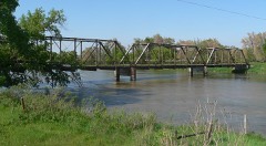 | North Loup Bridge | structure | 1992 | 92000704 |
 | People's Unitarian Church | building | 1984 | 84002497 |
 | Valley County Courthouse | building | 1990 | 89002235 |
Every wildfire the federal occurrence database records inside this county: 58 of them, burning about 7,028 acres. None started naturally and none was recorded as arson. Each settlement page carries the fires within five miles of it.
| Reported cause | Fires |
|---|---|
| Debris and open burning | 24 |
| Equipment and vehicle use | 20 |
| Missing data/not specified/undetermined | 12 |
| Smoking | 1 |
| Railroad operations and maintenance | 1 |
The five largest, by the area the report gives. None of them was recorded as arson.
| Date | Cause | Size | Reported by | Name on the report |
|---|---|---|---|---|
| 21 December 2016 | Debris and open burning | 5,500 acres | Nebraska Forest Service | not named |
| 8 April 2018 | Debris and open burning | 500 acres | Nebraska Forest Service | not named |
| 5 January 2012 | Debris and open burning | 500 acres | Nebraska Forest Service | not named |
| 4 December 2020 | Equipment and vehicle use | 150 acres | Nebraska Forest Service | not named |
| 10 August 2012 | Equipment and vehicle use | 75 acres | Nebraska Forest Service | not named |
| 12 April 2018 | Debris and open burning | 65 acres | Nebraska Forest Service | not named |
| 7 February 2015 | Debris and open burning | 60 acres | Nebraska Forest Service | not named |
| 31 March 2015 | Debris and open burning | 40 acres | Nebraska Forest Service | not named |
Every settlement page carries the fires within five miles of it - see the settlement index below.
The NOAA Storm Events Database holds 356 reports for this county, causing 12 deaths, 4 injuries and about $19,316,000 in recorded property damage. Each settlement page carries the reports that name it.
| Kind of event | Reports |
|---|---|
| Hail | 201 |
| Thunderstorm Wind | 106 |
| Tornado | 25 |
| Heavy Rain | 13 |
| Flash Flood | 7 |
| Flood | 2 |
| Lightning | 2 |
The most serious of them, by death, then injury, then recorded damage. The accounts are quoted exactly as the forecast office filed them.
| When | Event | Place named | Harm | What the report says |
|---|---|---|---|---|
| June 1953 | Tornado (F4) | not stated | 11 killed, $250,000 | no account filed |
| August 1960 | Tornado (F3) | not stated | 1 killed, 2 hurt, $25,000 | no account filed |
| May 1959 | Tornado (F2) | not stated | 2 hurt, $250,000 | no account filed |
| March 2019 | Flood | North Loup | $2,000,000 | no account filed |
| March 2019 | Flash Flood | North Loup | $2,000,000 | no account filed |
| May 2022 | Thunderstorm Wind | Arcadia | $1,500,000 | Wind gusts of 80 to 90 MPH were reported along and near this path. Peak measured wind gusts include: 89 MPH, by a mesonet station located eight miles west-southwest of Ord; 82 MPH, by a mesonet station located four miles west-southwest of Ord; 75 MPH, by a Nebraska Mesonet station located two miles northwest of Ord; 73 MPH, by a mesonet station located six miles southwest of Ord. Widespread damage was reported in and around Arcadia by a NWS Cooperative Observer, who estimated wind speeds to be 80 to 90 MPH with near-zero visibility due to blowing dirt. Numerous trees were uprooted or torn apart, and many buildings and grains bins were damaged or destroyed. Numerous pivots were overturned. Hail up to the size of ping pong balls was driven by this wind, enhancing the destructive nature of the storm. In and around Ord, law enforcement also reported widespread tree damage, along with fencing and shed damage. The NWS Cooperative Observer in Ord reported pea to dime size hail lasted for approximately 10-15 minutes. The Fort Hartsuff State Park area in far northern Valley County also reported tree damage. |
| June 1999 | Tornado (F3) | Ord | $1,500,000 | no account filed |
| July 2014 | Hail | North Loup | $1,000,000 | Hail up to the size of ping pong balls caused extensive crop damage in the area. |
| July 2014 | Hail | Arcadia | $1,000,000 | Hail ranged in size from quarters to ping pong balls. Crop damage was reported in the area. |
| July 2014 | Hail | Ord | $1,000,000 | Hail ranged in size from quarters to golf balls. |
| May 2011 | Thunderstorm Wind | Ord | $1,000,000 | Damage from wind gusts near and in excess of 80 MPH caused considerable damage to area grain bins and outbuildings, and also overturned pivots. At the Ord Airport, the roof was peeled off of one of the hangars, and one side of the building was ripped away. |
| June 2010 | Flash Flood | North Loup | $1,000,000 | no account filed |
| June 2024 | Thunderstorm Wind | North Loup | $500,000 | Wind gusts estimated to be near 80 MPH caused widespread damage in eastern Valley and western Greeley counties. Along with tree damage, a handful of power poles were snapped, and several irrigation pivots were flipped. A number of grain bins and outbuildings were damaged, and a home north of North Loup suffered siding damage and also had a couple of trailers shifted from their parked spots. |
| June 2013 | Thunderstorm Wind | Elyria | $500,000 | A machine shed located 11 miles west and 1 mile north of Ord was destroyed. A number of power poles were knocked down from this area and extended to approximately 4 miles west of Ord. Irrigation pivots were overturned approximately 4 miles west of Ord. The start time was an estimate from radar data. |
| June 2000 | Hail | Ord | $400,000 | no account filed |
| May 2025 | Hail | Elyria | $250,000 | A couple waves of strong to severe storms dropped hail up to the size of ping pong balls. |
| July 2011 | Thunderstorm Wind | North Loup | $250,000 | Wind gusts were estimated at 80 MPH, causing tree damage across town and crop damage around the area. Two larger tree limbs were knocked down in town and fell onto vehicles. |
| June 2003 | Tornado (F1) | Arcadia | $250,000 | A tornado moved across western Valley county and was reported by an off duty meteorologist from the SPC. |
| July 1987 | Tornado (F2) | not stated | $250,000 | no account filed |
| August 1981 | Tornado (F1) | not stated | $250,000 | no account filed |
| May 2023 | Hail | Elyria | $175,000 | Hail up to the size of ping pong balls was reported along this path, ground was still partially white after sunrise. |
| May 2020 | Thunderstorm Wind | Arcadia | $150,000 | Wind gusts estimated to be near 70 MPH knocked over 3 irrigation pivots. |
| July 2013 | Thunderstorm Wind | North Loup | $150,000 | A two story barn was heavily damaged, with one wall collapsed, by wind gusts estimated to be approaching 100 MPH. A nearby home suffered minor siding damage. A storage shed was moved from its foundation, being shoved up next to a power pole. Multiple grain bins also were damaged in the area, including one which was ripped from its foundation. |
| July 2000 | Hail | Ord | $150,000 | no account filed |
| July 2023 | Thunderstorm Wind | (Odx)Sharp Fld Ord | $100,000 | Wind gusts of 66 MPH and 81 MPH were measured by the Ord Airport ASOS. These wind gusts caused widespread tree damage across Ord. Large trees were damaged, some snapped in half, and large tree branches were downed. |
| May 2022 | Hail | Arcadia | $100,000 | The NWS Cooperative Observer located two miles west of Arcadia reported hail up to the size of ping pong balls, driven by wind gusts of 80 to 90 MPH. |
| August 2019 | Flash Flood | Ord | $100,000 | Measurements and radar estimations showed rainfall totals as high as 5-7 inches within the area area, with the highest totals in northwestern and south central portions of the county, including a CoCoRaHS station with 5.87 six miles west of Elyria and an unofficial public total of 6.25 nine miles west-southwest of Elyria. Emergency management reported that several rural roads were under water, with at least one road southwest of Elyria completely washed out. |
| August 2019 | Flash Flood | Arcadia | $100,000 | Radar estimation showed that rainfall amounts of 2 to 5 inches fell across the area. Emergency management reported some rural roads were covered with water. Approximately 6 miles south of Ord, a bridge crossing Mira Creek was washed out. |
| August 2014 | Thunderstorm Wind | Ord | $100,000 | Wind gusts were estimated to be near 70 MPH. Crop damage was reported in the area. |
| August 2014 | Thunderstorm Wind | Arcadia | $100,000 | Wind gusts were estimated to be near 60 MPH. Crop and tree damage was reported in the area. |
| July 2013 | Thunderstorm Wind | Ord | $100,000 | Wind gusts estimated at 60 MPH were accompanied by quarter sized hail. |
| July 2014 | Hail | Ord | $100,000 | no account filed |
| July 2013 | Hail | Ord | $100,000 | no account filed |
| August 2005 | Hail | Ord | $100,000 | no account filed |
| June 2000 | Hail | Ord | $100,000 | no account filed |
| June 2014 | Thunderstorm Wind | North Loup | $75,000 | Large tree limbs and branches were reported down around the community of North Loup. |
| May 2012 | Hail | North Loup | $75,000 | no account filed |
| May 2012 | Hail | Ord | $75,000 | no account filed |
| June 1997 | Hail | Arcadia | $75,000 | no account filed |
| June 1997 | Hail | Arcadia | $75,000 | no account filed |
| May 1998 | Hail | Ord | $60,000 | no account filed |
| May 2025 | Hail | Arcadia | $50,000 | Hail up to the size of half dollars was reported. |
| June 2014 | Tornado (EF0) | Elyria | $50,000 | This tornado was witnessed by spotters in the area and maximum wind speeds were estimated at 85 mph. The tornado started in a grove of trees along the North Loup River. The tornado snapped a power pole and damaged a pivot as it traveled east southeast before lifting. A widespread area of sporadic wind damage extended south and east of the tornado, including across Fort Hartsuff State Historical Park. The buildings at the fort sustained no damage, but some trees on the property were damaged. At least one badly damaged tree was planted during the fort's active tenure of 1874 to 1881. |
| June 2011 | Tornado (EF1) | North Loup | $50,000 | This tornado touched down near the Davis Creek Reservoir, or approximately 5 miles south of North Loup, and lifted approximately 4 miles south of North Loup. At the Davis Creek Campground, it was estimated that 60 percent of the trees were damaged, and 2 restroom facilities suffered roof damage. The maximum wind speed of this tornado was estimated to be 90 MPH. |
| May 2025 | Hail | Elyria | $50,000 | no account filed |
| May 2013 | Hail | Elyria | $50,000 | no account filed |
| May 2013 | Hail | Arcadia | $50,000 | no account filed |
| May 2013 | Hail | Arcadia | $50,000 | no account filed |
| July 2007 | Hail | Elyria | $50,000 | no account filed |
| August 2005 | Hail | Ord | $50,000 | no account filed |
| July 2003 | Thunderstorm Wind | Ord Arpt | $50,000 | no account filed |
| June 2003 | Hail | Arcadia | $50,000 | no account filed |
| June 2002 | Heavy Rain | Ord | $50,000 | no account filed |
| June 2000 | Thunderstorm Wind | Ord | $50,000 | no account filed |
| July 2000 | Hail | Evelyn Sharp Arpt | $50,000 | no account filed |
| May 1998 | Hail | Ord | $45,000 | no account filed |
| July 2013 | Thunderstorm Wind | Ord | $40,000 | Wind gusts estimated to be near 85 MPH resulted in roof damage at a home, with a 8 to 10 foot section being removed. Some of the insulation was found in trees to the south of the home. |
| July 2000 | Tornado (F0) | Arcadia | $40,000 | no account filed |
| June 1997 | Hail | Ord | $40,000 | no account filed |
| May 2019 | Thunderstorm Wind | Ord | $35,000 | Wind gusts estimated to be near 65 MPH resulted in the destruction of a lean-to and caused a tree to fall onto a house. |
The Survey's mineral resources record lists 1 working inside this county. It still produces. Each settlement page carries the workings within five miles of it.
| Commodity | Workings |
|---|---|
| Sand and Gravel, Construction | 1 |
The least common of them first, because a county's hundredth gravel pit says nothing its first ten did not.
| Where | Site | Commodity | Status | Recorded |
|---|---|---|---|---|
| Ulrich Pit and Plant No. 1 & 2 | Sand and Gravel, Construction | Producer |
Named settlements recorded in the Geographic Names Information System, each with the topographic sheets covering it. Villages, hamlets and abandoned places alike. Each is shown with the nearest named watercourse or landform and the survey quadrangle it falls on.
Arcadia township · 68815 · On Hawthorne Creek · Arcadia West quadrangle
11 sheets, 1951 to 1985
Geranium township · 68862 · Comstock quadrangle
11 sheets, 1952 to 1994
No longer a settlement
The vanished settlements of Valley County: the places named above that are no longer on the map.