 Block
From the record
One of 4 National Register listings published here for Chase County · listed in 2008 · category: Building.
Sources: the case file at the National Archives · the National Register database, National Park Service
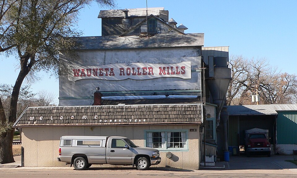
Listed on the National Register of Historic Places in 2008.
One of 4 National Register listings published here for Chase County · listed in 2008 · category: Building.
Sources: the case file at the National Archives · the National Register database, National Park Service
Regional context, not property-specific evidence. The federal wildfire occurrence database lists 5 fires within 5 miles of Wauneta Roller Mills between 2004 and 2010, burning about 5 acres in total. 1 started naturally. None was recorded as arson. Distance is straight-line from the map coordinates, so a fire counted here may appear on a neighbouring settlement's page as well.
| Reported cause | Fires |
|---|---|
| Equipment and vehicle use | 4 |
| Natural | 1 |
The most recent of them, most recent first, with the day each was reported and the service that recorded it.
| Date | Cause | Size | Reported by | Name on the report |
|---|---|---|---|---|
| 7 July 2007 | Equipment and vehicle use | 2.0 acres | Nebraska Forest Service | not named |
| 3 July 2007 | Natural | 1.0 acres | Nebraska Forest Service | not named |
| 13 July 2010 | Equipment and vehicle use | 1.0 acres | Nebraska Forest Service | not named |
| 12 July 2010 | Equipment and vehicle use | 1.0 acres | Nebraska Forest Service | not named |
| 5 May 2004 | Equipment and vehicle use | under an acre | Nebraska Forest Service | not named |
Regional context, not property-specific evidence. The National Weather Service names Wauneta, the town this property stands in, in 60 storm reports between 1994 and 2025: 36 hail, 20 thunderstorm wind, 2 tornado, 1 lightning. The reports record 2 injuries. Each account below is quoted exactly as the forecast office filed it, from the NOAA Storm Events Database, and each date opens the federal record of that event.
| When | Event | Place named | Harm | What the report says |
|---|---|---|---|---|
| August 2002 | Lightning | Wauneta | 2 hurt | Lightning struck two teenage boys as they corralled cattle. One boy was struck and then the lightning bolt branched off striking the other boy. Both were knocked unconscious. The first boy that was struck was treated for 2nd degree burns on his legs, chest, and bottoms of feet and 3rd degree burns on his arms. The second boy that was struck only received minor injuries. |
| June 2010 | Flood | Wauneta | $100,000 | Thunderstorms with prolonged heavy rain falling on already saturated ground caused low land flooding along the Stinking Water Creek in eastern Chase County. Water was flowing over several county roads. |
| June 2011 | Thunderstorm Wind | Wauneta | $50,000 | Damaging winds in excess of 60 mph caused extensive large tree damage in Wauneta. Structural damage occurred to a home by a fallen tree with a center pivot irrigation system was overturned. |
| October 1997 | Thunderstorm Wind | Wauneta | $50,000 | Thunderstorm winds in excess of 60 mph caused significant damage to a farm house and barn. |
| March 2007 | Thunderstorm Wind | Wauneta | $30,000 | Thunderstorm outflow winds destroyed a milk barn at a farmstead. |
| March 2007 | Thunderstorm Wind | Wauneta | $30,000 | Thunderstorm outflow winds lifted the metal roof off the Frenchman Valley Coop building and deposited it in the road with some pieces breaking windows in nearby businesses. Harchelroad Motors also sustained roof damage to their business and had windows broken out of several vehicles. Other vehicles were lifted and turned. |
| June 2024 | Hail | Wauneta | $25,000 | Hail up to 3 inches in diameter was reported along with numerous car windows broken out in Wauneta. |
| June 2003 | Hail | Wauneta | $15,000 | no account filed |
| June 2011 | Hail | Wauneta | $10,000 | General public reported siding and roof damage caused by golf ball sized hail. |
| August 2004 | Hail | Wauneta | $6,000 | no account filed |
| May 2005 | Hail | Wauneta | $5,000 | no account filed |
| July 2013 | Thunderstorm Wind | Wauneta | $1,000 | Thunderstorm wind gusts estimated at 60 MPH blew sheets of tin across a field. |
| June 2011 | Hail | Wauneta | $1,000 | General public reported quarter to half dollar sized hail caused siding damage on west side of home along with one broken window. |
| June 2025 | Hail | Wauneta | - | Quarter sized hail along with 50 to 60 MPH winds reported at this location. |
| June 2024 | Thunderstorm Wind | Wauneta | - | Public estimates 60 MPH wind gusts along with heavy rain. |
| May 2023 | Thunderstorm Wind | Wauneta | - | Trained spotter reports 60 MPH winds in Wauneta. |
| July 2023 | Hail | Wauneta | - | Public reported quarter size hail near Wauneta. |
| July 2023 | Thunderstorm Wind | Wauneta | - | A personal weather station north of Wauneta measured a 58 mph wind gust. |
| June 2022 | Thunderstorm Wind | Wauneta | - | Power outage reported in Wauneta. |
| August 2019 | Thunderstorm Wind | Wauneta | - | Estimated 60 mph wind gust. |
| May 2016 | Thunderstorm Wind | Wauneta | - | Thunderstorm wind gusts estimated at 60 to 70 MPH in the city of Wauneta. |
| August 2015 | Thunderstorm Wind | Wauneta | - | Public estimated 75 mph wind gusts. |
| July 2015 | Hail | Wauneta | - | Hail ranged in size from golf ball to teacup. |
| June 2011 | Hail | Wauneta | - | Chase County Sheriff reported golf ball sized hail and very heavy rain in Wauneta. |
| June 2008 | Tornado (EF0) | Wauneta | - | A supercell tornado touched down briefly over open rangeland. The supercell also produced 3 other tornadoes in Chase County. |
| May 2008 | Tornado (EF0) | Wauneta | - | Trained spotters reported a brief tornado touchdown over an open field. After the storm, a rooster pheasant was found with no feathers. |
| August 1999 | Thunderstorm Wind | Wauneta | - | A severe thunderstorm moved through Chase County. The storm was accompanied by very large hail, damaging wind, and several reports of funnel clouds. Bean and corn crops north and west of Imperial were damaged extensively. In Imperial, numerous trees were uprooted by the wind, two power poles were broken, and lines were blown down. The damage to utilities in Imperial required about 280 man-hours of overtime to repair. At the Trinidad Bean facility, bins and doors were damaged by the wind. |
| July 1995 | Hail | Wauneta | - | Thunderstorm winds and golfball hail knocked down trees destroyed a hog shed and blew the roof off a trailer home. |
| July 1994 | Thunderstorm Wind | Wauneta | - | Four inches of rain in twenty minutes caused street flooding in Wauneta. A farmhouse northwest of town was damaged by strong winds. |
| May 2025 | Thunderstorm Wind | Wauneta | - | no account filed |
| June 2024 | Hail | Wauneta | - | no account filed |
| May 2024 | Hail | Wauneta | - | no account filed |
| May 2023 | Hail | Wauneta | - | no account filed |
| August 2020 | Hail | Wauneta | - | no account filed |
| May 2016 | Hail | Wauneta | - | no account filed |
| July 2015 | Hail | Wauneta | - | no account filed |
| July 2015 | Hail | Wauneta | - | no account filed |
| July 2015 | Hail | Wauneta | - | no account filed |
| August 2013 | Hail | Wauneta | - | no account filed |
| August 2011 | Hail | Wauneta | - | no account filed |
| June 2010 | Hail | Wauneta | - | no account filed |
| May 2008 | Thunderstorm Wind | Wauneta | - | no account filed |
| May 2008 | Hail | Wauneta | - | no account filed |
| September 2007 | Hail | Wauneta | - | no account filed |
| June 2007 | Hail | Wauneta | - | no account filed |
| May 2006 | Hail | Wauneta | - | no account filed |
| May 2005 | Hail | Wauneta | - | no account filed |
| May 2004 | Hail | Wauneta | - | no account filed |
| May 2004 | Thunderstorm Wind | Wauneta | - | no account filed |
| July 2004 | Thunderstorm Wind | Wauneta | - | no account filed |
| June 2003 | Thunderstorm Wind | Wauneta | - | no account filed |
| June 2003 | Hail | Wauneta | - | no account filed |
| August 2002 | Hail | Wauneta | - | no account filed |
| July 2000 | Thunderstorm Wind | Wauneta | - | no account filed |
| May 1999 | Hail | Wauneta | - | no account filed |
| August 1998 | Hail | Wauneta | - | no account filed |
| July 1996 | Hail | Wauneta | - | no account filed |
| May 1996 | Hail | Wauneta | - | no account filed |
| October 1996 | Hail | Wauneta | - | no account filed |
| July 1995 | Hail | Wauneta | - | no account filed |
No historic map-sheet match is published for this property yet. That does not mean no map exists. This record needs a coordinate-quality review before it can be joined to a sheet boundary. Browse the county's mapped places while that work is pending.
| National Archives record | The nomination case file for reference 08000169 in Record Group 79. |
| Chase County | All 4 listed properties in this county. |