 Block
From the record
One of 6 National Register listings published here for Hamilton County · listed in 2014 · category: Building.
Sources: the National Register database, National Park Service

Listed on the National Register of Historic Places in 2014.
One of 6 National Register listings published here for Hamilton County · listed in 2014 · category: Building.
Sources: the National Register database, National Park Service
Regional context, not property-specific evidence. The federal wildfire occurrence database lists 50 fires within 5 miles of Temple Craft Building between 2008 and 2020, burning about 266 acres in total. 1 started naturally. 1 was recorded as arson. Distance is straight-line from the map coordinates, so a fire counted here may appear on a neighbouring settlement's page as well.
| Reported cause | Fires |
|---|---|
| Debris and open burning | 18 |
| Missing data/not specified/undetermined | 14 |
| Equipment and vehicle use | 10 |
| Smoking | 4 |
| Power generation/transmission/distribution | 1 |
| Arson/incendiarism | 1 |
| Misuse of fire by a minor | 1 |
| Natural | 1 |
The most recent of them, most recent first, with the day each was reported and the service that recorded it.
| Date | Cause | Size | Reported by | Name on the report |
|---|---|---|---|---|
| 27 September 2009 | Equipment and vehicle use | under an acre | Nebraska Forest Service | not named |
| 27 September 2008 | Missing data/not specified/undetermined | 2.0 acres | Nebraska Forest Service | not named |
| 26 August 2011 | Smoking | 1.0 acres | Nebraska Forest Service | not named |
| 24 July 2011 | Equipment and vehicle use | 1.0 acres | Nebraska Forest Service | not named |
| 5 June 2009 | Debris and open burning | under an acre | Nebraska Forest Service | not named |
| 28 June 2018 | Missing data/not specified/undetermined | 1.0 acres | Nebraska Forest Service | not named |
| 22 June 2009 | Missing data/not specified/undetermined | under an acre | Nebraska Forest Service | not named |
| 12 June 2020 | Equipment and vehicle use | 2.0 acres | Nebraska Forest Service | not named |
Regional context, not property-specific evidence. The National Weather Service names Aurora, the town this property stands in, in 86 storm reports between 1994 and 2024: 46 hail, 25 thunderstorm wind, 6 tornado, 4 heavy rain. The reports record 1 injury. Each account below is quoted exactly as the forecast office filed it, from the NOAA Storm Events Database, and each date opens the federal record of that event.
| When | Event | Place named | Harm | What the report says |
|---|---|---|---|---|
| May 1996 | Lightning | Aurora | 1 hurt, $500 | no account filed |
| July 2021 | Thunderstorm Wind | Aurora | $5,000,000 | A wind gust of 78 MPH was recorded by a mesonet station located just west of Aurora at 10:54 PM CDT and a gust of 64 MPH was recorded by a mesonet station located in Aurora at 10:57 PM CDT. Along with numerous reports of tree damage and power outages, there was minor roof and window damage to a few business in Aurora, as well as reports of tree limbs falling onto cars. |
| July 2021 | Thunderstorm Wind | Aurora | $5,000,000 | Wind gusts were estimated to be near 95 MPH through this area. Widespread significant tree damage, crop damage, downed power lines, snapped power poles, and power outages were reported along and near this path. A high-voltage transmission line was downed approximately four miles southwest of Aurora, crossing Interstate 80 and causing traffic issues. Several outbuildings and grain bins were damaged or destroyed, mainly south of Aurora. A 66 ft by 120 ft outbuilding just southwest of Aurora was damaged, with sheets of metal blown upwards of 200 yards away. Semi-trucks were blown over on Interstate 80 near both the Aurora and Giltner exits. |
| June 2022 | Hail | Aurora | $1,500,000 | Quarter to golf ball size hail was reported across Aurora. |
| June 2022 | Hail | Aurora | $500,000 | Hail ranging in size from quarters to golf balls was reported along and near this path. |
| June 2003 | Hail | Aurora | $500,000 | Record setting hail occurred on the north side of Aurora. |
| June 1997 | Thunderstorm Wind | Aurora | $400,000 | no account filed |
| April 1999 | Tornado (F1) | Aurora | $300,000 | no account filed |
| June 2017 | Hail | Aurora | $125,000 | Up to hen egg size hail was reported in and near Aurora. |
| May 2019 | Hail | Aurora | $100,000 | Hail up to the size of tennis balls and baseballs was reported along this path, including on Highway 14. |
| May 2019 | Hail | Aurora | $100,000 | Hail ranging in size from quarters to golf balls was reported along this path. Drifts of quarter to half-dollar size hail was reported at a residence 4 miles north of Aurora. |
| June 2002 | Hail | Aurora | $75,000 | no account filed |
| May 2021 | Tornado (EF0) | Aurora | $45,000 | This landspout moved north-northwest for approximately 1 mile before diminishing roughly as it crossed Highway 14 just south of Aurora. The main observable damage was damage to storage building roll-up doors, a couple of larger overhead doors and a downed power line. The treeline near the start of the tornado had evidence of cornstalks lofted up into the trees and power lines. |
| July 2003 | Thunderstorm Wind | Aurora | $35,000 | no account filed |
| June 2003 | Tornado (F0) | Aurora | $30,000 | A brief touch down occurred just west of Aurora and was observed by an off duty NWS meteorologist. |
| July 2007 | Flash Flood | Aurora | $30,000 | no account filed |
| October 1998 | Thunderstorm Wind | Aurora | $30,000 | no account filed |
| July 2015 | Thunderstorm Wind | Aurora | $25,000 | Wind gusts estimated to be near 60 MPH resulted in tree damage and power outages in Aurora. |
| May 2019 | Hail | Aurora | $25,000 | no account filed |
| June 2014 | Hail | Aurora | $25,000 | no account filed |
| May 2012 | Hail | Aurora | $25,000 | no account filed |
| May 1996 | Lightning | Aurora | $20,000 | no account filed |
| July 1997 | Lightning | Aurora | $15,000 | Lightning struck two homes in Aurora causing minor damage to each. |
| September 2015 | Hail | Aurora | $15,000 | no account filed |
| September 1997 | Hail | Aurora | $15,000 | no account filed |
| May 1998 | Hail | Aurora | $10,000 | no account filed |
| July 1996 | Hail | Aurora | $10,000 | no account filed |
| July 1996 | Thunderstorm Wind | Aurora | $10,000 | no account filed |
| July 2008 | Thunderstorm Wind | Aurora | $5,000 | no account filed |
| May 2007 | Flash Flood | Aurora | $5,000 | no account filed |
| November 2000 | Hail | Aurora | $5,000 | no account filed |
| October 2023 | Thunderstorm Wind | Aurora | $3,000 | Wind gusts of 62 MPH were measured by the Aurora Airport AWOS and by a mesonet station located two miles west of Aurora. Minor tree damage was reported in Aurora by emergency management. |
| May 1996 | Thunderstorm Wind | Aurora | $1,500 | no account filed |
| May 2024 | Thunderstorm Wind | Aurora | - | A wind gust of 60 MPH was measured by a mesonet station located two miles west of Aurora. |
| May 2024 | Thunderstorm Wind | Aurora | - | A wind gust of 60 MPH was measured by a mesonet station located two miles west of Aurora. |
| June 2023 | Tornado (EFU) | Aurora | - | Emergency management confirmed report of a tornado. Location was based on their information along with media/social media photos and videos showing the tornado developing near Interstate 80 and then moving passing just west of Aurora before dissipating. No damage was reported. |
| April 2022 | Thunderstorm Wind | Aurora | - | A wind gust of 60 MPH was measured by a mesonet station located two miles west of Aurora. |
| May 2021 | Tornado (EFU) | Aurora | - | This landspout was rated an unknown EF scale and unknown wind speed because of the lack of observable damage. The location was estimated based on pictures and videos. |
| July 2020 | Thunderstorm Wind | Aurora | - | A wind gust of 73 MPH was recorded by a mesonet station located 3 miles south-southwest of Aurora. |
| May 2018 | Thunderstorm Wind | Aurora | - | Wind gusts were estimated to be near 60 MPH. |
| August 2017 | Heavy Rain | Aurora | - | A 24-hour precipitation amount of 4.06 inches was recorded. |
| August 2017 | Heavy Rain | Aurora | - | A 24-hour precipitation amount of 6.00 inches was recorded 5 miles north of Aurora. |
| May 2016 | Heavy Rain | Aurora | - | Storm total rainfall report was 4.01 inches. |
| October 2016 | Hail | Aurora | - | Hail ranging in size from nickels to ping pong balls was reported. |
| June 2014 | Thunderstorm Wind | Aurora | - | Wind gusts were estimated at 60 MPH. |
| April 2013 | Hail | Aurora | - | Dime size hail covered Highway 34 from 1.5 mile to 3 miles east of Aurora. |
| November 2012 | Hail | Aurora | - | Nickel size hail was accompanied by 50 mph winds. |
| June 2011 | Hail | Aurora | - | Nickel size hail was reported south of Aurora on Highway 14. |
| June 2011 | Heavy Rain | Aurora | - | Storm total rainfall amount of 3.13 inches was reported. |
| June 2010 | Thunderstorm Wind | Aurora | - | Reports from the area included tree and barn damage as well as one overturned pivot. |
| June 2010 | Thunderstorm Wind | Aurora | - | Wind gusts estimated at 60 mph. |
| June 2010 | Thunderstorm Wind | Aurora | - | A few tree limbs were knocked down. |
| May 2006 | Thunderstorm Wind | Aurora | - | A brief gustnado occurred south of Aurora and was photographed by an off-duty NWS employee. |
| May 1994 | Hail | Aurora | - | Baseball-size hail occurred in Aurora. |
| May 1994 | Thunderstorm Wind | Aurora | - | Thunderstorm winds blew an old mobile home into the side of another building in Aurora. Small outbuildings and trees were also damaged. Thunderstorm winds also blew over two grain bins near Marquette. |
| August 2021 | Hail | Aurora | - | no account filed |
| June 2017 | Hail | Aurora | - | no account filed |
| May 2016 | Hail | Aurora | - | no account filed |
| September 2015 | Hail | Aurora | - | no account filed |
| June 2014 | Hail | Aurora | - | no account filed |
No historic map-sheet match is published for this property yet. That does not mean no map exists. This record needs a coordinate-quality review before it can be joined to a sheet boundary. Browse the county's mapped places while that work is pending.
Other National Register properties close enough to walk or drive between, ordered by distance from this one. Both positions come from the same geocoding pass that matched these properties to their map sheets.
| Photograph | Property | Distance | Listed |
|---|---|---|---|
 | Hamilton County Courthouse | under 500 feet | 1985 |
 | United Brethren Church | 0.1 miles | 2008 |
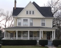 | Streeter-Peterson House | 0.2 miles | 1991 |
 | IOOF Opera House | 6.2 miles | 1988 |
| National Archives record | The nomination case file for reference 14000916 in Record Group 79. |
| Hamilton County | All 6 listed properties in this county. |