 Block
From the record
One of 21 National Register listings published here for Buffalo County · listed in 2016 · category: Building.
Sources: the National Register database, National Park Service
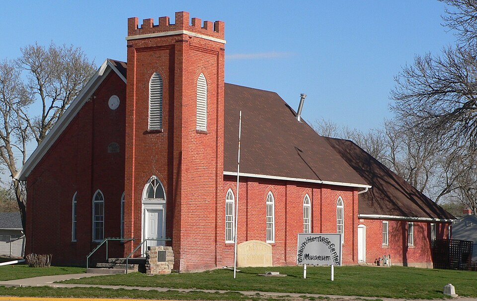
Listed on the National Register of Historic Places in 2016.
One of 21 National Register listings published here for Buffalo County · listed in 2016 · category: Building.
Sources: the National Register database, National Park Service
Regional context, not property-specific evidence. The federal wildfire occurrence database lists 27 fires within 5 miles of Gibbon Baptist Church between 2007 and 2020, burning about 86 acres in total. None started naturally. None was recorded as arson. Distance is straight-line from the map coordinates, so a fire counted here may appear on a neighbouring settlement's page as well.
| Reported cause | Fires |
|---|---|
| Debris and open burning | 8 |
| Equipment and vehicle use | 7 |
| Missing data/not specified/undetermined | 7 |
| Power generation/transmission/distribution | 2 |
| Railroad operations and maintenance | 2 |
| Smoking | 1 |
The most recent of them, most recent first, with the day each was reported and the service that recorded it.
| Date | Cause | Size | Reported by | Name on the report |
|---|---|---|---|---|
| 30 September 2020 | Smoking | 2.0 acres | Nebraska Forest Service | not named |
| 9 July 2020 | Equipment and vehicle use | 1.0 acres | Nebraska Forest Service | not named |
| 9 July 2020 | Missing data/not specified/undetermined | 1.0 acres | Nebraska Forest Service | not named |
| 9 July 2018 | Equipment and vehicle use | 1.0 acres | Nebraska Forest Service | not named |
| 7 June 2007 | Railroad operations and maintenance | 5.0 acres | Nebraska Forest Service | not named |
| 7 May 2017 | Equipment and vehicle use | 1.0 acres | Nebraska Forest Service | not named |
| 14 May 2020 | Missing data/not specified/undetermined | 3.0 acres | Nebraska Forest Service | not named |
| 14 May 2013 | Debris and open burning | 1.0 acres | Nebraska Forest Service | not named |
Regional context, not property-specific evidence. The federal mineral resources record lists 2 workings within 5 miles of Gibbon Baptist Church: 2 producers. All of them still produce. What was taken out: Sand and Gravel, Construction. Distance is straight-line from the map coordinates, so a quarry counted here may appear on a neighbouring settlement's page as well.
| Where | Site | Commodity | Status | Recorded |
|---|---|---|---|---|
| Bruner's Sand and Gravel | Sand and Gravel, Construction | Producer | ||
| Leonard Pit and Plant | Sand and Gravel, Construction | Producer |
Regional context, not property-specific evidence. The National Weather Service names Gibbon, the town this property stands in, in 57 storm reports between 1994 and 2024: 31 hail, 17 thunderstorm wind, 4 tornado, 2 heavy rain. No death or injury is recorded in these reports. Each account below is quoted exactly as the forecast office filed it, from the NOAA Storm Events Database, and each date opens the federal record of that event.
| When | Event | Place named | Harm | What the report says |
|---|---|---|---|---|
| July 2014 | Thunderstorm Wind | Gibbon | $3,000,000 | Wind gusts were estimated to be at least 70 MPH, with a gust of 68 MPH measured 3 miles south of Gibbon. Accompanied by hail up to the size of golf balls, the combination caused significant crop and tree damage in the area, with many fields reduced to stubble with crops determined to be complete losses. Damage to campers was also reported at the Windmill State Recreation Area near Interstate 80. |
| July 2014 | Hail | Gibbon | $3,000,000 | Hail up to the size of golf balls accompanied wind gusts of at least 70 MPH through the area. This combination led to significant tree and crop damage, with many fields reduced to stubble and crops were complete losses. Damage to campers was also reported at the Windmill State Recreation Area near Interstate 80. |
| June 1998 | Thunderstorm Wind | Gibbon | $700,000 | no account filed |
| December 2021 | Tornado (EF0) | Gibbon | $300,000 | This tornado is a continuation of the tornado that touched down in Kearney County, north of Minden. This tornado was typical for the day, likely intermittent with regard to ground circulation and impacting rural areas. Much of the path damage can be traced to center irrigation pivots either partially or fully overturned. The tornado damaged a couple power poles and peeled back some roofing material at the Rowe Sanctuary. A measured wind gust 83 MPH was recorded at the sanctuary as the storm passed. Damage was a bit sparse north of the river. The tornadic circulation likely crossed Interstate 80 about three miles west of the Gibbon interchange before knocking over a couple more pivots and lifting just southwest of Gibbon. The maximum estimated speed of 85 MPH was based upon the measured wind gust at the sanctuary and damage to nearby power poles. |
| December 2021 | Tornado (EF0) | Gibbon | $250,000 | This tornado is a continuation of the tornado that touched down east of Lowell in Kearney County and traveled north-northeast across the Platte River into Buffalo County, lifting near Shelton. Damage was sparse, but a few center irrigation pivots and minor tree damage was found. The tornadic circulation likely crossed Interstate 80 about 2.5 miles west of the Shelton interchange. The tornado moved across one farmstead where a garage was completely destroyed. Minor tree damage was also noted. The damage to the garage was the primary basis for the 80 MPH maximum wind speed estimate. The tornado tipped one more pivot before lifting just northeast of the farmstead. |
| May 2013 | Hail | Gibbon | $250,000 | no account filed |
| June 2014 | Hail | Gibbon | $150,000 | Hail ranging in size from golf balls to baseballs was reported from 2 miles south of Gibbon to the west edge of Gibbon. |
| May 2004 | Thunderstorm Wind | Gibbon | $150,000 | no account filed |
| August 1999 | Thunderstorm Wind | Gibbon | $150,000 | no account filed |
| July 2024 | Lightning | Gibbon | $125,000 | Lightning is the suspected cause of a house fire in Gibbon, which destroyed the home. |
| July 2005 | Hail | Gibbon | $100,000 | no account filed |
| June 2006 | Thunderstorm Wind | Gibbon | $80,000 | no account filed |
| December 2021 | Thunderstorm Wind | Gibbon | $75,000 | Emergency management reported wind damage in Gibbon. Roof damage was reported to a local trailer park, and a grain bin in town was destroyed. |
| May 2013 | Hail | Gibbon | $75,000 | Hail ranging in size from half dollars to hen eggs was reported. |
| May 2005 | Tornado (F0) | Gibbon | $50,000 | A tornado passed just northwest of Gibbon and tossed a barn on top of a garage at a farm northwest of town. |
| June 2011 | Hail | Gibbon | $50,000 | no account filed |
| July 2018 | Hail | Gibbon | $25,000 | Hail the size of quarters to half dollars was reported. |
| August 2015 | Thunderstorm Wind | Gibbon | $25,000 | Multiple eight-inch diameter tree branches were blown down, and consequently knocked down a power line in Gibbon. |
| July 2011 | Thunderstorm Wind | Gibbon | $25,000 | Tree limbs up to 6 inches in diameter were blown down in Gibbon. |
| May 2005 | Tornado (F0) | Gibbon | $25,000 | A tornado skipped along a path from northwest of Gibbon to north of Shelton. The tornado only caused minor damage along its path, but was easily sighted from just about any direction. |
| April 2019 | Hail | Gibbon | $25,000 | no account filed |
| April 2019 | Hail | Gibbon | $25,000 | no account filed |
| July 2018 | Hail | Gibbon | $25,000 | no account filed |
| June 2011 | Hail | Gibbon | $25,000 | no account filed |
| August 1997 | Hail | Gibbon | $20,000 | no account filed |
| May 2007 | Hail | Gibbon | $10,000 | no account filed |
| June 2024 | Thunderstorm Wind | Gibbon | - | Wind gusts estimated to be near 60 MPH were accompanied by half dollar size hail. |
| October 2023 | Thunderstorm Wind | Gibbon | - | Wind gusts were estimated to be near 60 MPH. |
| May 2022 | Hail | Gibbon | - | Dime to quarter size hail was accompanied by wind gusts estimated to be near 55 MPH. |
| June 2019 | Thunderstorm Wind | Gibbon | - | A wind gust of 71 MPH was measured by a home weather station located 4 miles north of Gibbon. |
| August 2015 | Thunderstorm Wind | Gibbon | - | Wind gusts were estimated to be near 60 MPH at campground area near Interstate 80 exit 285. |
| June 2013 | Hail | Gibbon | - | Penny-size hail covered Interstate 80. |
| May 2011 | Heavy Rain | Gibbon | - | Storm total rainfall of 4.29 inches reported over last 24 hours by a NeRAIN observer. |
| June 2009 | Thunderstorm Wind | Gibbon | - | Wind gusts estimated at 60 to 70 mph. |
| June 2008 | Hail | Gibbon | - | Hail accompanied by winds estimated at 60 to 70 mph. |
| June 1994 | Thunderstorm Wind | Gibbon | - | Thunderstorm winds up to 80 mph caused tree damage at Gibbon. Golf ball-size hail caused crop damage near Riverdale. |
| June 2024 | Hail | Gibbon | - | no account filed |
| May 2022 | Hail | Gibbon | - | no account filed |
| June 2022 | Hail | Gibbon | - | no account filed |
| June 2022 | Hail | Gibbon | - | no account filed |
| June 2022 | Hail | Gibbon | - | no account filed |
| April 2019 | Hail | Gibbon | - | no account filed |
| March 2017 | Thunderstorm Wind | Gibbon | - | no account filed |
| June 2014 | Hail | Gibbon | - | no account filed |
| July 2014 | Hail | Gibbon | - | no account filed |
| May 2013 | Hail | Gibbon | - | no account filed |
| May 2012 | Hail | Gibbon | - | no account filed |
| October 2011 | Hail | Gibbon | - | no account filed |
| May 2007 | Heavy Rain | Gibbon | - | no account filed |
| May 2007 | Flash Flood | Gibbon | - | no account filed |
| August 2006 | Thunderstorm Wind | Gibbon | - | no account filed |
| May 2005 | Funnel Cloud | Gibbon | - | no account filed |
| May 2005 | Hail | Gibbon | - | no account filed |
| May 2005 | Hail | Gibbon | - | no account filed |
| April 2001 | Thunderstorm Wind | Gibbon | - | no account filed |
| May 1998 | Hail | Gibbon | - | no account filed |
| April 1998 | Hail | Gibbon | - | no account filed |
No historic map-sheet match is published for this property yet. That does not mean no map exists. This record needs a coordinate-quality review before it can be joined to a sheet boundary. Browse the county's mapped places while that work is pending.
Other National Register properties close enough to walk or drive between, ordered by distance from this one. Both positions come from the same geocoding pass that matched these properties to their map sheets.
| Photograph | Property | Distance | Listed |
|---|---|---|---|
| Shelton Public Library | 6.2 miles | 2024 | |
 | Meisner Bank Building | 6.3 miles | 1999 |
 | Kilgore Bridge | 7.0 miles | 1992 |
| National Archives record | The nomination case file for reference 15000897 in Record Group 79. |
| Buffalo County | All 21 listed properties in this county. |