 Block
From the record
One of 226 National Register listings published here for Douglas County · listed in 1980 · category: Building.
Sources: the case file at the National Archives · the National Register database, National Park Service
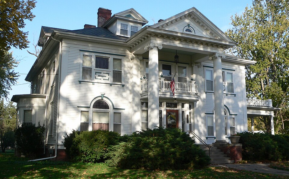
Listed on the National Register of Historic Places in 1980.
One of 226 National Register listings published here for Douglas County · listed in 1980 · category: Building.
Sources: the case file at the National Archives · the National Register database, National Park Service
Regional context, not property-specific evidence. The federal wildfire occurrence database lists 16 fires within 5 miles of J. C. Robinson House between 2001 and 2019, burning about 48 acres in total. None started naturally. None was recorded as arson. Distance is straight-line from the map coordinates, so a fire counted here may appear on a neighbouring settlement's page as well.
| Reported cause | Fires |
|---|---|
| Debris and open burning | 9 |
| Missing data/not specified/undetermined | 3 |
| Recreation and ceremony | 1 |
| Power generation/transmission/distribution | 1 |
| Smoking | 1 |
| Fireworks | 1 |
The most recent of them, most recent first, with the day each was reported and the service that recorded it.
| Date | Cause | Size | Reported by | Name on the report |
|---|---|---|---|---|
| 5 July 2008 | Fireworks | under an acre | Nebraska Forest Service | not named |
| 9 June 2007 | Missing data/not specified/undetermined | 1.0 acres | Nebraska Forest Service | not named |
| 30 June 2001 | Debris and open burning | 15 acres | Nebraska Forest Service | not named |
| 13 June 2017 | Power generation/transmission/distribution | 1.0 acres | Nebraska Forest Service | not named |
| 6 May 2018 | Missing data/not specified/undetermined | 5.0 acres | Nebraska Forest Service | not named |
| 6 May 2018 | Missing data/not specified/undetermined | 3.0 acres | Nebraska Forest Service | not named |
| 9 April 2011 | Debris and open burning | under an acre | Nebraska Forest Service | not named |
| 6 April 2017 | Recreation and ceremony | 2.0 acres | Nebraska Forest Service | not named |
Regional context, not property-specific evidence. The federal mineral resources record lists 2 workings within 5 miles of J. C. Robinson House: 2 producers. All of them still produce. What was taken out: Sand and Gravel, Construction. Distance is straight-line from the map coordinates, so a quarry counted here may appear on a neighbouring settlement's page as well.
| Where | Site | Commodity | Status | Recorded |
|---|---|---|---|---|
| Hartford Sand & Gravel Pits 1a & 1b | Sand and Gravel, Construction | Producer | ||
| Lyman-Richey Sand & Gravel Corp. | Sand and Gravel, Construction | Producer |
Regional context, not property-specific evidence. The National Weather Service names Waterloo, the town this property stands in, in 31 storm reports between 1993 and 2025: 11 hail, 8 flood, 5 thunderstorm wind, 3 flash flood. The reports record 1 death and 4 injuries. Each account below is quoted exactly as the forecast office filed it, from the NOAA Storm Events Database, and each date opens the federal record of that event.
| When | Event | Place named | Harm | What the report says |
|---|---|---|---|---|
| August 2025 | Thunderstorm Wind | Waterloo | 1 killed, 1 hurt, $3,810,000 | A highly damaging swath of severe thunderstorm winds moved across Douglas County, Nebraska, predominantly impacting the western and northern parts of the county, including the Omaha metropolitan area on the morning on August 9th, 2025. ||The storm produced damaging wind gusts, with the highest being an estimated 100 mph reported by broadcast media southwest of Washington at 04:52 CST. Multiple locations experienced estimated and measured gusts of 90 mph or higher. An estimated 95 mph gust was reported in Bennington, also responsible for destroying a shed. An estimated 95 mph gust and snapped power poles south of Valley. An estimated 95 mph gust and snapped trees with large diameters north-northeast of Elkhorn. Measured gusts by NWS employees up to 90 mph near Valley.||Tragically, significant impacts occurred east-southeast of Yutan at 04:55 CST when an estimated 90 mph gust uprooted a very large tree (approximately two feet in diameter) that fell onto a vehicle, resulting in one fatality and one injury. Widespread structural and tree damage impacted parts of the area. In Bennington, damage reports included the destruction of a shed and large snapped tree branches. Near Elkhorn, a large tree fell onto a truck and minivan. North-northeast of Valley, there was damage to a roof, resulting in insulation blown across the road, and an overturned semi-truck. The severe winds also downed power lines southwest of Washington and destroyed a boat canopy southeast of Washington.||The property damage to public infrastructure across Douglas County from these severe winds is estimated to be $3,810,332.00. This figure reflects only the costs associated with repairing public assets and does not account for the extensive damage sustained by private and commercial properties throughout Saline County. |
| April 2024 | Tornado (EF4) | Waterloo | 3 hurt | This tornado developed about one quarter mile west of the West Q Road and 255th Street intersection in Western Douglas county where trees were knocked down and a farmstead sustained outbuilding damage. The tornado continued northeast crossing agricultural fields and flipping numerous center pivots, eventually crossing 252nd Street. The tornado caused EF-2 damage as it approached Highway 92, damaging numerous homes and striking an acreage northwest of the Highway 92 (West Center street) and Highway 275 intersection. Several center pivots were overturned as the tornado continued northeast crossing east of Highway 275, causing EF-2 damage to several acreages, homes, and outbuildings along Highway 275/240th Street. Continuing northeast, the tornado crossed 234th Street near Harney Street where it damaged a horse farm and an acreage as well as a home along Dodge Street/Highway 6 before crossing Dodge Street causing roof and outbuilding damage at the Junkstock Farm. The tornado crossed the Elkhorn River, damaging trees and flipping center pivots in an acreage along Blondo Street just south of the railroad tracks. The tornado continued into the western part of Elkhorn approximately one-half mile south-southwest of the intersection of West Maple Road and 216th Street. One home sustained high-end EF-2 damage losing large sections of its roofs. Another home just to the north had total destruction of the structure, resulting in EF-4 damage. The tornado moved across Prospect Hills Cemetery, damaging headstones, and moved across West Maple Avenue severely damaging a landscape business before entering the Ramblewood subdivision. Numerous homes in the subdivision received EF-3 damage with only small interior rooms standing. EF-3 damage persisted as the tornado continued north-northeastward damaging homes between 212th Street and Kestrel Parkway, again leaving only interior rooms standing. Two homes at the intersection of North 212th Street and Larimor Avenue were completely destroyed, resulting in a second instance of EF-4 damage. The tornado then crossed Fort Street about one-third of a mile east of 216th Street, causing the collapse of new development homes. This damage was also consistent with that of an EF-3 tornado. The tornado then veered to the northeast across mainly rural areas of northwestern Douglas County, between Fort Street and Military Road. By the time the tornado crossed Highway 31, it reached its peak width of 1 mile wide. EF-1 damage was noted in this area with several power poles and trees snapped. The tornado narrowed to about one-half mile wide and moved into residential development just northwest of the intersection of 180th Street and Military Road, where EF-1 damage was observed due to loss of roofs. The tornado then moved into Benningtons Newport Landing neighborhood, causing high-end EF-2 damage by removing large sections of several home's roofs and collapsing some exterior walls. The tornado then moved across Bennington Lake, crossing just west of the intersection of Highway 36 and 168th Street, snapping the tops off of numerous trees. It then moved across agricultural land, damaging farm outbuildings southeast of the intersection of 168th Street and Dutch Hall Road, before crossing into Washington County. All walls of this home were collapsed. However, the walls were not attached to the foundation in a way that would discriminate between EF-3 and EF-4 damage. Thus, high-end EF-3 damage was determined. Peak estimated winds for this segment of the tornado's track were at 170 miles per hour. The maximum width of the tornado in this segment was 1450 yards, with an average width of approximately 900 yards. |
| July 2024 | Thunderstorm Wind | Waterloo | $35,000,000 | A line of intense thunderstorms swept across the entirety of Douglas County, impacting the largest metropolitan area in the Omaha NWS County Warning Area. As these storms entered the western part of the county, 80 miles per hour wind gusts were likely being produced, with a 76 miles per hour wind gust measured at the Omaha National Weather Service, and a 75 miles per hour wind gust measured by a mesonet station in west Millard. As the storms moved east across the county, the winds continued to intensify with widespread significant damage to trees, powerlines, and structures. In Waterloo, a roof was blown off of a commercial building, and in Midtown, a storefront awning and front faade was completely destroyed. Wind gusts in the area were measured as high as 90 miles per hour, both by the Eppley Airfield ASOS and a mesonet station in Bennington. As such, straight line winds were estimated to be as high as 100 miles per hour with these storms as they moved through the Omaha metro. Power outages lasted for a week in some areas of the county, with OPPD estimated approximately 20 million dollars in damage in the county. Total damages from these storms are estimated to be 35 million in Douglas county alone. |
| May 2024 | Funnel Cloud | Waterloo | - | Law Enforcement took a video of a funnel cloud a few miles east of Yutan. |
| July 2023 | Flood | Waterloo | - | Fire department reported minor street flooding in Waterloo. |
| April 2022 | Thunderstorm Wind | Waterloo | - | Public reported a tree snapped off and vehicle windows blow out by a thunderstorm wind gust. Security camera footage confirms a gustnado that was not connected to the cloud base. |
| August 2021 | Flash Flood | Waterloo | - | Law enforcement reported lots of street flooding with water level up to bumper of cars. |
| April 2020 | Hail | Waterloo | - | Public reported 1 inch hail near 240th and Q Streets. |
| March 2019 | Flood | Waterloo | - | The Nebraska State Patrol reported that State Highway 92 bridge over the Elkhorn River has washed away. |
| March 2019 | Flash Flood | Waterloo | - | Water went over ther the road on Maple, Street Dodge Street, and Center Street at the Elkhorn River. All these roads along the Elkhorn were closed. Dodge street apprroach to the bridge received extensive damage with huge broken up pieces of roadway that were undermined by flood waters. The couple small bridges west of the river on Center Street collapsed. |
| March 2019 | Flood | Waterloo | - | Water over the bridge on Maple Street. Road is being closed. |
| March 2019 | Flood | Waterloo | - | Evacuations taking place in cabins near Highway 92. |
| June 2018 | Flood | Waterloo | - | Thunderstorms dropped 1 1/2 to 2 1/4 inches of rain over western Douglas County on the night of the 19th that caused water to go over Nebraska Highway 64 near Waterloo. |This caused the highway to be closed. |
| May 2017 | Hail | Waterloo | - | Quarter size hail reported in the Lake Zorinsky area. |
| May 2017 | Hail | Waterloo | - | One inch hail was reported in the Lake Zorinsky area. |
| June 2016 | Flood | Waterloo | - | The heavy rainfall propelled the West Papillion Creek into Minor flood. The flooding was significant enough that it crossed State Highway 64 necessitating the closure of the roadway for a time. |
| January 2015 | Flood | Waterloo | - | An ice jam was reported along the Platte River during the early morning hours on the 27th, flooding portions of Twin Rivers State Park. The jam eventually broke free the early morning of the 29th. |
| May 2014 | Tornado (EF1) | Waterloo | - | This tornado initially touched down in Saunders county and had a total track length of around 10.7 miles with around 7 miles of the track in Douglas county. This was the first of 2 tornadoes that hit near the Omaha area this evening. |
| March 2010 | Flood | Waterloo | - | A local ice jam caused minor flooding which crossed a county road near Harrison and 252nd Streets. This ice jam caused a little more flooding in Saunders county and also flooded lowlands in Sarpy county as well. Little damage was noted in Douglas county from this flooding. |
| August 2010 | Hail | Waterloo | - | Hail around 1 inch in diameter was reported in the Waterloo area with golf ball-size reported just to the northeast of town. |
| June 2008 | Heavy Rain | Waterloo | - | Rainfall of 2.10 inches fell between 1215 pm and 115 pm CDT near Waterloo. The heavy rain caused signifcant ponding in the area. |
| May 2008 | Flash Flood | Waterloo | - | Heavy rain caused flooding across part of the Two Rivers Campground and roads in the area forcing several campers to evacuate their campsites. |
| June 2008 | Thunderstorm Wind | Waterloo | - | Thunderstorm wind gusts estimated at around 60 mph caused scattered tree damage in the Omaha area with large limbs or trees downed near |228th and Q and 96th and Harrison Streets. OPPD reported that 4,500 customers lost their power from the storm. |
| June 2008 | Hail | Waterloo | - | Hail between nickel and half dollar size was reported across sections of Omaha. Reports of hail this large were received from the Elkhorn area, from 168th and Pacific, 192nd and Center, the 1600 block of South 24th Street and from the Millard area. |
| June 2008 | Thunderstorm Wind | Waterloo | - | A fireworks tent was blown over by thunderstorm wind gusts around 70 mph. |
| May 2017 | Hail | Waterloo | - | no account filed |
| May 2017 | Hail | Waterloo | - | no account filed |
| June 2014 | Hail | Waterloo | - | no account filed |
| May 2013 | Hail | Waterloo | - | no account filed |
| June 2010 | Hail | Waterloo | - | no account filed |
| August 1993 | Hail | Waterloo | - | no account filed |
No historic map-sheet match is published for this property yet. That does not mean no map exists. This record needs a coordinate-quality review before it can be joined to a sheet boundary. Browse the county's mapped places while that work is pending.
Other National Register properties close enough to walk or drive between, ordered by distance from this one. Both positions come from the same geocoding pass that matched these properties to their map sheets.
| Photograph | Property | Distance | Listed |
|---|---|---|---|
| Main Street Bridge | 2.4 miles | 1992 | |
| Elkhorn Commercial Historic District (Additional Documentation) | 2.4 miles | 2024 | |
 | Elkhorn Town Hall | 2.4 miles | 2022 |
 | Lincoln Highway-Omaha to Elkhorn | 4.0 miles | 2003 |
| Lincoln Highway | 4.5 miles | 1987 | |
 | Carl Penke Farm | 7.0 miles | 2007 |
| National Archives record | The nomination case file for reference 80002452 in Record Group 79. |
| Douglas County | All 226 listed properties in this county. |