
BlockBefore
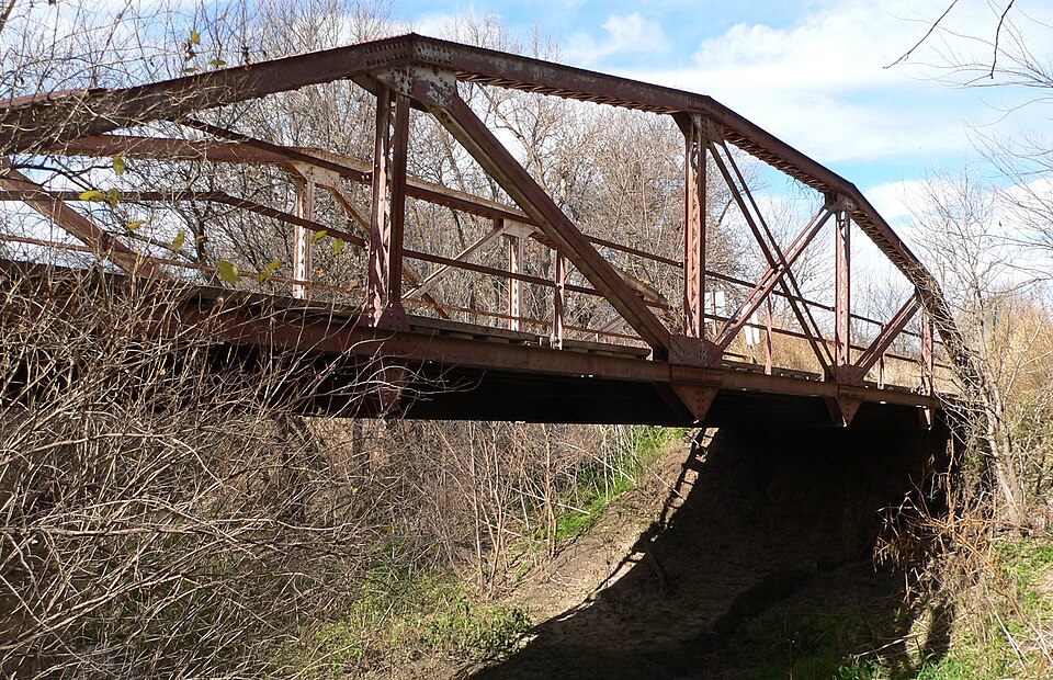
Photograph of Prairie Dog Creek Bridge
Photograph by Ammodramus, Public domain. Via Wikimedia Commons.

Prairie Dog Creek Bridge

Listed on the National Register of Historic Places in 1992.

From the record

“The Prairie Dog Creek Bridge, near Orleans, Nebraska, is a historic Camelback pony truss bridge that was built in 1913. It was designed and built by Monarch Engineering Co., with its steel was fabricated by Jones & Laughlin Steel Co.”

Wikipedia article Prairie Dog Creek Bridge, CC BY-SA 4.0.

One of 7 National Register listings published here for Harlan County · listed in 1992 · category: Structure.

Sources: the Wikipedia article · the case file at the National Archives · the National Register database, National Park Service

The listing

  • What is counted as historic. The nomination lists 1 structure as contributing to the listing.
  • Address. Twp. Rd. over Prairie Dog Cr., 8.5 mi. S and 1 mi. W of Orleans, Orleans, 68966
  • When was it listed? June 1992
  • Category. structure
  • Also known as. Highway Bridges in Nebraska MPS
  • Township. Eldorado township
  • National Register reference number. 92000712 - the number the National Park Service assigned this property when it was listed, and the key its nomination file is catalogued under at the National Archives.

Storms near this property

54 since 1996

Regional context, not property-specific evidence. The National Weather Service names Orleans, the town this property stands in, in 54 storm reports between 1996 and 2024: 35 hail, 12 thunderstorm wind, 4 heavy rain, 2 tornado. No death or injury is recorded in these reports. Each account below is quoted exactly as the forecast office filed it, from the NOAA Storm Events Database, and each date opens the federal record of that event.

WhenEvent Place namedHarm What the report says
June 2018Thunderstorm WindOrleans$350,000The emergency manager reported damage to a farmstead near this mesonet site. Damage included blown down power poles, building damage, uprooted trees, overturned pivots, windows blown out of a home and vehicles.
August 1996Thunderstorm WindOrleans$230,000no account filed
July 2000HailOrleans$150,000no account filed
June 2018HailOrleans$100,000Tennis ball to baseball size hail was reported.
May 2004HailOrleans$100,000no account filed
May 2014HailOrleans$50,000no account filed
August 1999Thunderstorm WindOrleans$50,000no account filed
August 2021Thunderstorm WindOrleans$25,000Tree damage was reported on the north side of town. Wind gusts estimate based on nearby mesonet measurement.
June 2011HailOrleans$25,000no account filed
June 2012Thunderstorm WindOrleans$15,000Wind gusts estimated at 60 mph resulted in downed trees along with power outages.
June 2002HailOrleans$10,000no account filed
August 1996HailOrleans$10,000no account filed
May 2008HailOrleans$2,000no account filed
April 2024Thunderstorm WindOrleans-A wind gust of 65 MPH was measured by a mesonet station located three miles north-northwest of Alma.
May 2024Thunderstorm WindOrleans-A wind gust of 59 MPH was measured by a mesonet station located six miles west of Huntley.
April 2022Tornado (EFU)Orleans-This tornado briefly touched down a few miles southwest of Orleans. Location and time was approximated from social media photos and radar. No damage was reported.
August 2021Heavy RainOrleans-A CoCoRaHS observer measured 6.22 of rain between 5 p.m. and midnight CDT.
August 2021Thunderstorm WindOrleans-A wind gust of 63 MPH was recorded by a mesonet station located six miles northwest of Orleans.
August 2020HailOrleans-Hail ranging in size from quarters to golf balls was reported along this path.
June 2019Flash FloodOrleans-Up to one foot of water was flowing across a low spot on Highway 136. Highway was closed until the flood waters receded. Low spots in some county gravel roads nearby were also washed out and/or had water flowing over them. An NeRAIN observer in Alma measured a 24-hour rain total of 3.13, most of which fell between 1-3 p.m. CDT on the 18th.
June 2018Heavy RainOrleans-A storm total rainfall amount of 3.70 inches three miles northeast of Stamford, 3.48 inches occurred two miles east of Stamford, 3.25 inches occurred 3 miles north of Alma, 3.02 inches occurred in Orleans.
September 2016Thunderstorm WindOrleans-Penny size hail accompanied the winds.
October 2011Heavy RainOrleans-Total rainfall over the past 24 hours of 3.70 inches was reported.
October 2011Heavy RainOrleans-Total rainfall over the past 24 hours of 3.81 inches was reported by a Nebraska Rainfall Assessment and Information Network observer.
May 2010HailOrleans-Hail was accompanied by wind gusts estimated between 55 and 60 mph.
June 2010Thunderstorm WindOrleans-Wind gusts estimated at 60 mph.
May 2004Tornado (F0)Orleans-A brief tornado was reported north of Orleans
May 2023HailOrleans-no account filed
April 2022HailOrleans-no account filed
May 2022HailOrleans-no account filed
May 2019HailOrleans-no account filed
September 2019HailOrleans-no account filed
May 2012HailOrleans-no account filed
June 2012HailOrleans-no account filed
September 2012HailOrleans-no account filed
June 2011HailOrleans-no account filed
May 2010HailOrleans-no account filed
June 2010HailOrleans-no account filed
September 2010HailOrleans-no account filed
June 2010HailOrleans-no account filed
June 2010Thunderstorm WindOrleans-no account filed
June 2007HailOrleans-no account filed
April 2006HailOrleans-no account filed
June 2005HailOrleans-no account filed
May 2005HailOrleans-no account filed
June 2005HailOrleans-no account filed
May 2002HailOrleans-no account filed
June 2002HailOrleans-no account filed
August 2001Thunderstorm WindOrleans-no account filed
June 2000HailOrleans-no account filed

Every storm recorded in Harlan County

Map coverage status

No historic map-sheet match is published for this property yet. That does not mean no map exists. This record needs a coordinate-quality review before it can be joined to a sheet boundary. Browse the county's mapped places while that work is pending.

Sources for this property

National Archives recordThe nomination case file for reference 92000712 in Record Group 79.
Wikipedia articleCommunity-written account of this property, licensed CC BY-SA.
Harlan CountyAll 7 listed properties in this county.

Provenance

  • Listing record. National Park Service National Register of Historic Places, listed-properties dataset, current to 2026-05-22.
  • Map join. Address geocoded through the United States Census geocoder, then tested against the published boundary of every sheet in the USGS Historical Topographic Map Collection.
  • How this page is made. Listing fields come from federal records; map-sheet coverage is a labelled coordinate-to-boundary calculation, not a source-field claim.
  • Storms. NOAA National Centers for Environmental Information, Storm Events Database https://www.ncei.noaa.gov/stormevents/ A work of the United States government, no copyright under 17 U.S.C. 105. Narratives are quoted verbatim from the National Weather Service report and are not edited or summarised.