 Block
From the record
One of 7 National Register listings published here for Harlan County · listed in 1992 · category: Structure.
Sources: the case file at the National Archives · the National Register database, National Park Service
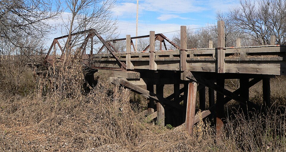
Listed on the National Register of Historic Places in 1992.
One of 7 National Register listings published here for Harlan County · listed in 1992 · category: Structure.
Sources: the case file at the National Archives · the National Register database, National Park Service
Regional context, not property-specific evidence. The federal wildfire occurrence database lists 8 fires within 5 miles of Sappa Creek Bridge between 2008 and 2018, burning about 72 acres in total. None started naturally. None was recorded as arson. Distance is straight-line from the map coordinates, so a fire counted here may appear on a neighbouring settlement's page as well.
| Reported cause | Fires |
|---|---|
| Debris and open burning | 3 |
| Equipment and vehicle use | 2 |
| Recreation and ceremony | 1 |
| Missing data/not specified/undetermined | 1 |
| Railroad operations and maintenance | 1 |
The most recent of them, most recent first, with the day each was reported and the service that recorded it.
| Date | Cause | Size | Reported by | Name on the report |
|---|---|---|---|---|
| 7 September 2013 | Equipment and vehicle use | 30 acres | Nebraska Forest Service | not named |
| 1 July 2010 | Missing data/not specified/undetermined | 1.0 acres | Nebraska Forest Service | not named |
| 6 June 2008 | Railroad operations and maintenance | 1.0 acres | Nebraska Forest Service | not named |
| 23 June 2016 | Equipment and vehicle use | 2.0 acres | Nebraska Forest Service | not named |
| 5 May 2018 | Recreation and ceremony | 1.5 acres | Nebraska Forest Service | not named |
| 9 March 2009 | Debris and open burning | 30 acres | Nebraska Forest Service | not named |
| 18 March 2009 | Debris and open burning | 1.0 acres | Nebraska Forest Service | not named |
| 27 February 2016 | Debris and open burning | 5.0 acres | Nebraska Forest Service | not named |
Regional context, not property-specific evidence. The National Weather Service names Stamford, the town this property stands in, in 33 storm reports between 1996 and 2024: 20 hail, 5 thunderstorm wind, 4 tornado, 2 heavy rain. No death or injury is recorded in these reports. Each account below is quoted exactly as the forecast office filed it, from the NOAA Storm Events Database, and each date opens the federal record of that event.
| When | Event | Place named | Harm | What the report says |
|---|---|---|---|---|
| June 2023 | Hail | Stamford | $1,000,000 | A cluster of thunderstorms sliding east just north of the Nebraska-Kansas state line produced widespread severe weather across central and southern portions of Harlan County. Hail generally up to the size of golf balls was reported across this area, though isolated larger hail also likely fell. Wind gusts were estimated to be anywhere from 60 to 70 MPH, resulting in numerous reports of tree damage, including whole trees snapped and larger limbs downed. A farm machine shed was destroyed between Stamford and Orleans. The wind-driven large hail resulted in widespread damage to crops, siding, windows, and vehicles. |
| June 2023 | Thunderstorm Wind | Stamford | $1,000,000 | A cluster of thunderstorms sliding east just north of the Nebraska-Kansas state line produced widespread severe weather across central and southern portions of Harlan County. Hail generally up to the size of golf balls was reported across this area, though isolated larger hail also likely fell. Wind gusts were estimated to be anywhere from 60 to 80 MPH, resulting in numerous reports of tree damage, including whole trees snapped and larger limbs downed. Outbuilding damage was reported near Alma. The wind-driven large hail resulted in widespread damage to crops, siding, windows, and vehicles. |
| June 2011 | Tornado (EF1) | Stamford | $250,000 | This tornado skipped along a path which started approximately 8 miles south of Stamford and ended approximately 4 miles north of Stamford. It was noted that this tornado was stationary and multi-vortex early on in its life, and as it shifted to the north destroyed an outbuilding, quonset, and grain bin. Numerous tree limbs were also knocked down. The maximum wind speed of this tornado was estimated to be 95 MPH. |
| July 2005 | Hail | Stamford | $250,000 | no account filed |
| June 2000 | Thunderstorm Wind | Stamford | $250,000 | no account filed |
| May 2004 | Tornado (F0) | Stamford | $150,000 | A tornado set down briefly in far southwest Franklin county near Stamford and damaged a mobile home and upset several irrigation systems. |
| March 2019 | Hail | Stamford | $100,000 | Hail along this path ranged from quarter to tennis ball size. |
| May 2019 | Flood | Stamford | $100,000 | Numerous county roads across the area were impacted by heavy rainfall and the flooding of the Prairie Dog Creek. Bridges crossing the creek were under water. Prairie Dog Creek rising into minor flood stage is rare. The last time Prairie Dog Creek flooded at the Woodruff gauge was September of 1977. For this event, Prairie Dog Creek crested at 22.1 feet (flood stage is 21 feet), and that was the 6th highest crest on record. |
| June 2011 | Hail | Stamford | $100,000 | Hail up to the size of golf balls was reported, causing damage to area windows and crops. |
| May 2008 | Flash Flood | Stamford | $50,000 | Numerous areas in Harlan County picked up 3 to 4 inches of rain. This caused many rural roads to flood. |
| June 2001 | Hail | Stamford | $10,000 | no account filed |
| August 1996 | Thunderstorm Wind | Stamford | $10,000 | no account filed |
| June 1998 | Hail | Stamford | $5,000 | no account filed |
| May 2008 | Hail | Stamford | $2,000 | no account filed |
| June 2024 | Thunderstorm Wind | Stamford | - | A wind gust of 59 MPH was measured by a mesonet station located seven miles south-southeast of Stamford. |
| April 2022 | Tornado (EFU) | Stamford | - | This tornado briefly touched down several miles south of Stamford. Location and time was approximated from reports and radar. No damage was reported. |
| August 2021 | Heavy Rain | Stamford | - | A CoCoRaHS observer measured 6.16 of rain between 5 p.m. and midnight CDT. |
| August 2021 | Thunderstorm Wind | Stamford | - | A wind gust of 65 MPH was recorded by a mesonet station located five miles northeast of Stamford. |
| May 2015 | Tornado (EF0) | Stamford | - | This was a brief tornado that crossed Highway 89 between Stamford and Orleans. No damage was reported with this tornado. |
| June 2014 | Heavy Rain | Stamford | - | A storm total rainfall amount of 3.07 inches was reported by an NeRAIN observer. |
| May 2023 | Hail | Stamford | - | no account filed |
| April 2022 | Hail | Stamford | - | no account filed |
| June 2020 | Hail | Stamford | - | no account filed |
| May 2010 | Hail | Stamford | - | no account filed |
| May 2010 | Hail | Stamford | - | no account filed |
| June 2010 | Hail | Stamford | - | no account filed |
| June 2010 | Hail | Stamford | - | no account filed |
| August 2007 | Hail | Stamford | - | no account filed |
| June 2005 | Hail | Stamford | - | no account filed |
| August 1999 | Hail | Stamford | - | no account filed |
| June 1999 | Hail | Stamford | - | no account filed |
| June 1998 | Hail | Stamford | - | no account filed |
| June 1997 | Hail | Stamford | - | no account filed |
No historic map-sheet match is published for this property yet. That does not mean no map exists. This record needs a coordinate-quality review before it can be joined to a sheet boundary. Browse the county's mapped places while that work is pending.
Other National Register properties close enough to walk or drive between, ordered by distance from this one. Both positions come from the same geocoding pass that matched these properties to their map sheets.
| Photograph | Property | Distance | Listed |
|---|---|---|---|
| Hotel Orleans | 5.3 miles | 2021 | |
| Cordelia Bennett Preston Memorial Library | 5.3 miles | 2021 |
| National Archives record | The nomination case file for reference 92000713 in Record Group 79. |
| Harlan County | All 7 listed properties in this county. |