 Block
Hobbs, New Mexico
5 topographic sheets cover this place, the earliest surveyed in 1954 and the latest in 1969. It stands in the Hobbs census division. It lies in ZIP code area 88240. The Survey maps it on the Hobbs West quadrangle. 40,508 people lived here at the 2020 count. It stands 3,622 feet above sea level.
Research this city
Population over time
2 figuresHobbs grew from 34,122 to 40,508 between 2010 and 2020. These are the recorded population figures Wikidata holds for this place, reached through the Geographic Names Information System number this page is keyed on rather than by name, so they belong to this place and not to another of the same name. Most are census counts, but not all are: an early figure may be a founding or settlement estimate, and an estimate published within five years of a census is left out. The change column is computed, and is left blank where more than 20 years separate a figure from the one before it, because a gap that long is not a change between two counts.
| Year | People | Change |
|---|---|---|
| 2010 | 34,122 | |
| 2020 | 40,508 | +6,386 (+19%) |
Topographic sheets covering this place
3 surveys from 5 printed sheetsMatched by testing this settlement's coordinate against the published boundary of every sheet in the United States Geological Survey's historical collection. Each opens the scanned sheet at the Survey.
- 1954 USGS Hobbs quadrangle1:250000, 2 printings
- 1958 USGS Hobbs quadrangle1:250000
- 1969 USGS Hobbs West quadrangle1:24000, 2 printings
Photographs
8 of 17 photographs shown, 1940 to 1942Taken for the Office of War Information and the Farm Security Administration, who photographed the country between 1935 and 1944. Works of United States government photographers, with no known restriction on use. Each opens its catalogue record.
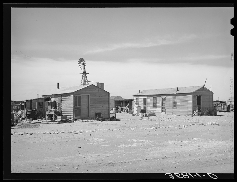
Lee, Russell, 1940. Library of Congress
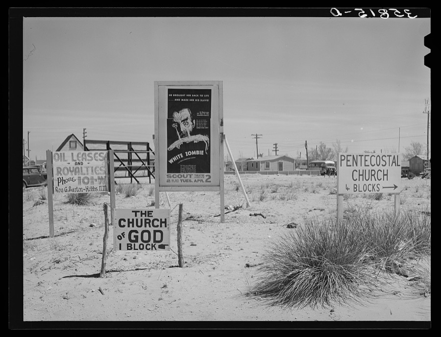
Lee, Russell, 1940. Library of Congress

Lee, Russell, 1940. Library of Congress
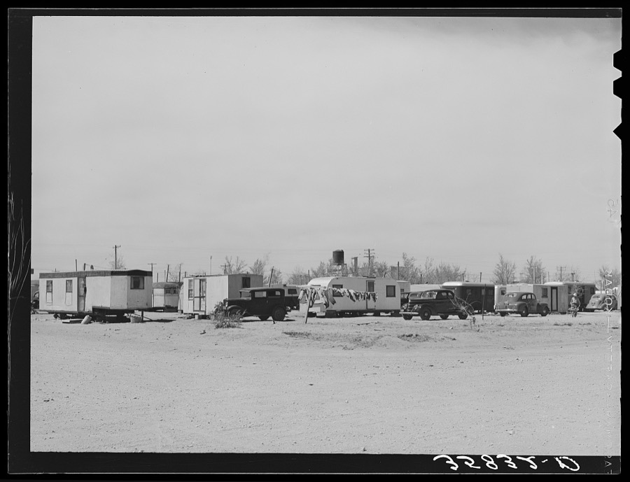
Lee, Russell, 1940. Library of Congress
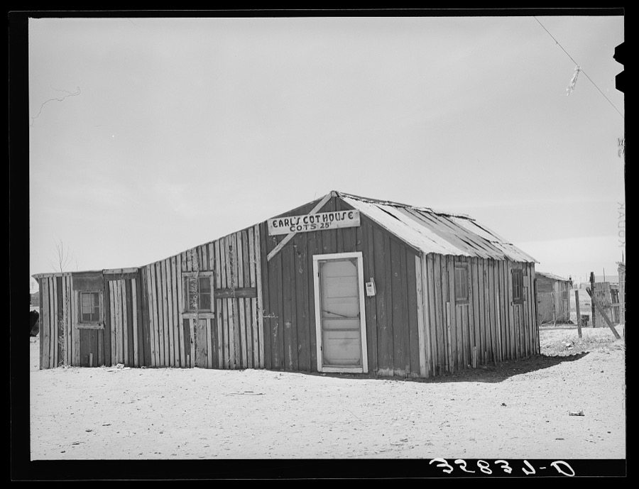
Lee, Russell, 1940. Library of Congress
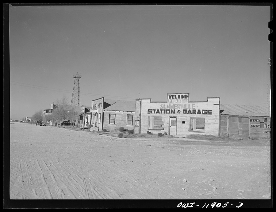
Vachon, John, 1942. Library of Congress
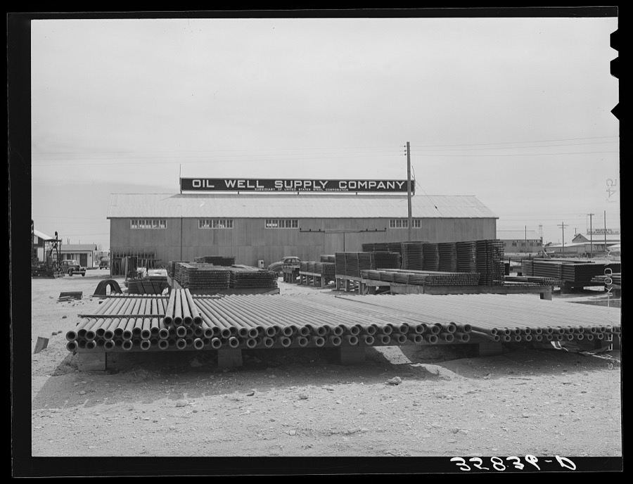
Lee, Russell, 1940. Library of Congress

Lee, Russell, 1940. Library of Congress
Every photograph of Lea County
Fires near this place
106 since 1993Regional context, not property-specific evidence. The federal wildfire occurrence database lists 106 fires within 5 miles of Hobbs between 1993 and 2019, burning about 12,078 acres in total. 1 started naturally. 6 were recorded as arson. Distance is straight-line from the map coordinates, so a fire counted here may appear on a neighbouring settlement's page as well.
| Reported cause | Fires |
|---|---|
| Missing data/not specified/undetermined | 79 |
| Equipment and vehicle use | 7 |
| Arson/incendiarism | 6 |
| Power generation/transmission/distribution | 6 |
| Debris and open burning | 5 |
| Misuse of fire by a minor | 1 |
| Smoking | 1 |
| Natural | 1 |
The most recent of them, most recent first, with the day each was reported and the service that recorded it.
| Date | Cause | Size | Reported by | Name on the report |
|---|---|---|---|---|
| 5 September 2019 | Smoking | 1.0 acres | Capitan District | 20-50650231N |
| 20 August 2003 | Missing data/not specified/undetermined | under an acre | New Mexico State Forestry Division | GARY |
| 1 August 1995 | Missing data/not specified/undetermined | under an acre | New Mexico State Forestry Division | ROSE ROAD |
| 9 July 1993 | Missing data/not specified/undetermined | 3.0 acres | New Mexico State Forestry Division | LOVELADY |
| 8 July 1993 | Missing data/not specified/undetermined | 5.0 acres | New Mexico State Forestry Division | ELLIOT |
| 7 July 1998 | Missing data/not specified/undetermined | under an acre | New Mexico State Forestry Division | W. SANGER |
| 6 July 2001 | Missing data/not specified/undetermined | under an acre | New Mexico State Forestry Division | MANHAN |
| 5 July 2001 | Misuse of fire by a minor | under an acre | New Mexico State Forestry Division | NADINE |
Settlements close enough to share some of these fires:
Mines and quarries near this place
10 of 21 shownRegional context, not property-specific evidence. The federal mineral resources record lists 21 workings within 5 miles of Hobbs: 16 unknowns, 4 producers, 1 past producer. 4 still produce. What was taken out: Sand and Gravel, Construction, Limestone, General, Stone, Sand and Gravel, Construction, Limestone, General, Stone. Distance is straight-line from the map coordinates, so a quarry counted here may appear on a neighbouring settlement's page as well.
| Where | Site | Commodity | Status | Recorded |
|---|---|---|---|---|
| Lea County Pit | Stone | Unknown | ||
| Lea County Pit | Sand and Gravel, Construction, Limestone, General, Stone | Producer | Sedimentary | |
| Lea County Pits | Limestone, General | Producer | Sedimentary | |
| Monument Pit | Limestone, General | Producer | Sedimentary | |
| Airport Pit | Sand and Gravel, Construction | Producer | ||
| Old Tomco Pit | Sand and Gravel, Construction | Past Producer | Sedimentary | |
| State Hwy Pit No 56-107-S | Sand and Gravel, Construction | Unknown | ||
| Thomason Pit | Sand and Gravel, Construction | Unknown | ||
| Un. Grav. Pit | Sand and Gravel, Construction | Unknown | ||
| Un. Grav. Pit | Sand and Gravel, Construction | Unknown |
Storms near this place
60 of 219 shownRegional context, not property-specific evidence. The National Weather Service names Hobbs in 219 storm reports between 1993 and 2025: 120 hail, 55 thunderstorm wind, 35 flash flood, 3 heavy rain. No death or injury is recorded in these reports. Each account below is quoted exactly as the forecast office filed it, from the NOAA Storm Events Database, and each date opens the federal record of that event.
| When | Event | Place named | Harm | What the report says |
|---|---|---|---|---|
| May 1997 | Hail | Hobbs | $27,000,000 | This storm moving to the southeast became an HP Supercell as it passed over the city of Hobbs. By the time the storm arrived over the southern parts of town, hail up to tennis ball size was falling along with strong winds. Most of the trees over the southern 1/3 of town were stripped of their leaves, and numerous houses and cars suffered damage. Streets had hail stacked up over one foot deep in some areas. This storm moved to the southeast into Texas and continued to produce severe weather in Andrews, Winkler, and Ward Counties. |
| May 2013 | Thunderstorm Wind | Hobbs | $300,000 | A thunderstorm moved over Lea County and knocked down power lines west and south of Hobbs as well as in Hobbs. Fires started due to the downed power lines. A transformer exploded and others burned on power poles in Hobbs. The cost of damage is a very rough estimate. |
| May 2005 | Hail | Hobbs | $150,000 | Storm spotters reported that sporadic tennis ball size hailstones accompanied smaller hailstones in downtown Hobbs. Extensive damage occurred as windows were shattered in vehicles, homes, and businesses. No injuries were reported. |
| May 2005 | Hail | Hobbs | $150,000 | A left moving supercell thunderstorm quickly propagated northeast across eastern Lea County during the late afternoon of the 10th. This storm produced a swath of destructive hail ranging in size from nickels to golfballs as it moved from southwest of Hobbs, in the vicinity of the Hobbs Airport, and then over the city. Local officials reported extensive damage to vehicles, roofs, and windows. No injuries were reported. |
| May 2005 | Thunderstorm Wind | Hobbs | $100,000 | Local officials reported that wind gusts to 60 MPH accompanied the large hail north of Hobbs. These winds blew large hail horizontally and destroyed lightweight structures such as sheds and carports. |
| August 2021 | Thunderstorm Wind | Hobbs | $95,000 | A thunderstorm produced wind damage near Hobbs. Six power poles were snapped along Highway 18 near University of the Southwest. A few trees were uprooted at Rockwind Golf Course. The time was estimated by radar. The peak wind speed was estimated to be 95 mph. The cost of damage is a very rough estimate. |
| July 2005 | Thunderstorm Wind | Hobbs | $80,000 | Severe thunderstorm winds gusting to 65 miles per hour accompanied large hail that fell three miles north of Hobbs. Outflow winds knocked power poles down across town creating widespread power outages in the city of Hobbs. |
| June 2025 | Hail | Hobbs | $65,000 | Emergency management sent reports of broken car windows and multiple alarm calls due to golf ball-size hail falling in Hobbs. The time of occurrence is estimated from radar. The cost of damages is also estimated. |
| May 1997 | Tornado (F1) | Hobbs | $60,000 | A strong mesocyclone on the leading edge of the severe thunderstorm moving to the ESE produced a tornado on the southeast flank of the storm. This storm displayed some characteristics of an HP supercell, but with much of the forward flank missing.Damage ranged from F0 on the southern end (probably from an RFD) to F1 damage in the heart of the tornado path. A damage survey discovered a highly convergent pattern to the debris path of the tornado. Damage ranged from travel trailers overturned, to mobile homes pushed from foundation and roof sections missing, to a barn that was levelled and unrecognizable. |
| June 2013 | Thunderstorm Wind | Hobbs | $40,000 | A thunderstorm moved over Lea County and resulted in brown-out conditions, snapped power poles, and downed trees in Hobbs. Wind gusts were estimated to be around 65 mph. The cost of damage is a rough estimate. |
| August 2003 | Flash Flood | Hobbs | $30,000 | Numerous thunderstorms developed along an approaching cold front across Lea County. Most of the thunderstorm activity was concentrated across the northern parts of the county. An isolated thunderstorm developed on the west side of Hobbs. This storm was nearly stationary for an extended period of time, and resulted in extensive flash flooding in the city. The fire department conducted several high water rescues to extract people from stalled vehicles, however, no injuries were reported. |
| June 2017 | Thunderstorm Wind | Hobbs | $26,000 | A thunderstorm moved across Lea County and produced wind damage in Hobbs. A horse barn was blown into a solar panel array at the New Mexico Junior College. There was wind damage at the Albertsons Grocery Store near West Bender Boulevard. Pieces of the HVAC equipment were lifted off the roof of the Albertsons. The time was estimated from radar. The cost of damage is a very rough estimate. |
| May 2022 | Thunderstorm Wind | Hobbs | $25,000 | A thunderstorm produced wind damage one mile north northeast of Hobbs, NM. Trees were uprooted or snapped and a roof was blown off. The cost of damage is a very rough estimate. |
| August 2007 | Flash Flood | Hobbs | $20,000 | Street flooding became widespread beginning on the north side of Hobbs and then expanded to the south side of the city. One foot of water covered the intersection of Grimes and Joe Harvey streets. Cars were stalled at the intersection of Joe Harvey and New Mexico State Highway 118 as a result of over two feet of water covering the road. |
| June 2004 | Flash Flood | Hobbs | $20,000 | Local officials reported between one and four feet of water flowing through some city streets in Hobbs. Several vehicles were washed off of the roadways. Several high water rescues were conducted, but no injuries were reported. |
| October 2002 | Flash Flood | Hobbs | $20,000 | Law officials reported stalled vehicles with high water rescues. No injuries were reported. |
| May 1997 | Tornado (F0) | Hobbs | $20,000 | Damage occurred just west of the Hobbs city limit where RFD and tornadic winds were superimposed. The damage included a 15x20 ft wooden roof taken off an old shed, parts of two other roofs damaged, an awning from a trailer destroyed, a trailer pushed 3-4 feet off its foundation, and two utility poles downed. The tornado was sighted, and a faint trail of it could be traced in the debris pattern upon inspection, but RFD winds occurred in the area as well with much of the debris blown in a divergent pattern. |
| June 1996 | Thunderstorm Wind | Hobbs | $20,000 | no account filed |
| May 2023 | Thunderstorm Wind | Hobbs | $15,000 | Lea County Emergency Manager reports multiple downed power poles along Highway 18 in Hobbs. The exact locations and time is estimated from radar. Property damage cost is an estimation. |
| June 2005 | Thunderstorm Wind | Hobbs | $15,000 | Damaging thunderstorm winds struck the Hobbs vicinity around 22:00 MST. Law enforcement officials estimated that winds gusted to 60 MPH near the Hobbs Airport at 21:45 MST. The severe thunderstorm winds spread east into the city during the next fifteen minutes, downing large trees and power lines. Downed power lines left the southern half of the city without electricity by 23:00 MST. The thunderstorm winds were followed by large hail. |
| May 2005 | Thunderstorm Wind | Hobbs | $15,000 | An isolated thunderstorm produced damaging winds in Hobbs during the early evening hours of the 23rd. The Hobbs Police Department reported that large trees, power poles and lines were blown down by the severe winds. |
| September 1999 | Thunderstorm Wind | Hobbs | $15,000 | A collapsing thunderstorm produced damaging outflow winds in Hobbs that knocked down 12 telephone poles and several trees. Storage sheds blown over or destroyed as well. |
| June 2017 | Thunderstorm Wind | Hobbs | $10,000 | A thunderstorm moved across Lea County and produced wind damage in Hobbs. Windows were blown out at KHOB Radio on N. Bensing Road and power poles were blown down along N. Bender Boulevard. The cost of damage is a very rough estimate. |
| July 1999 | Thunderstorm Wind | Hobbs | $10,000 | Microburst winds in Hobbs, uprooted trees, downed utility poles, and took the roof off one trailer. |
| May 1996 | Thunderstorm Wind | Hobbs | $10,000 | no account filed |
| May 2022 | Thunderstorm Wind | Hobbs | $9,000 | A thunderstorm produced wind damage one mile north northeast of Hobbs, NM. One inch tree limbs were broken and shingles were blown off of a roof. The cost of damage is a very rough estimate. |
| August 2018 | Flash Flood | Hobbs | $8,000 | Heavy rain moved across Lea County and produced flash flooding in Hobbs. Water was up to three feet at the intersection of Bender and Dal Paso Streets in Hobbs. Some roads were barricaded and cars were stranded. The cost of damage is a very rough estimate. |
| June 2001 | Thunderstorm Wind | Hobbs | $7,000 | Power poles and trees blown down. Power knocked out to much of city. |
| June 2017 | Thunderstorm Wind | Hobbs | $6,000 | A thunderstorm moved across Lea County and produced wind damage in Hobbs. A large section of the roof was blown off of the Albertsons store on North Grimes. The cost of damage is a very rough estimate. |
| January 2017 | Thunderstorm Wind | Hobbs | $5,000 | Thunderstorms moved across Lea County and produced wind damage eight miles west of Hobbs. Powerlines were blown down by the thunderstorm winds and started a fire. The wind speed was estimated and the cost of damage is a very rough estimate. |
| June 2013 | Flash Flood | Hobbs | $5,000 | Heavy rain moved across Lea County and produced flash flooding in Hobbs. There were high water rescues as a result of the flooding. The cost of damage is a rough estimate. |
| August 2005 | Flash Flood | Hobbs | $5,000 | The Hobbs Police Department reported that several city streets were flooded. The floodwaters floated a deputy's car and several residents were stranded, though none had to be rescued. The public also reported that Turner Street was under nearly half a foot of running water. |
| August 2005 | Thunderstorm Wind | Hobbs | $5,000 | A second storm blew down a power pole and several large light poles on the south side of Hobbs on the evening of the 23rd. |
| June 2003 | Thunderstorm Wind | Hobbs | $5,000 | A trained weather spotter reported severe thunderstorm winds which resulted in downed power lines in the city of Hobbs. |
| August 2009 | Flood | Hobbs | $4,000 | Local law enforcement reported water up to the windows of a vehicle at a well known low water crossing. |
| October 2015 | Flash Flood | Hobbs | $3,500 | Heavy rainfall caused flooded roads and four high water rescues in the City of Hobbs that were reported by law enforcement. The cost of damage is a very rough estimate. |
| August 2015 | Flash Flood | Hobbs | $3,000 | Heavy rain moved across Lea County and produced flash flooding in Hobbs. Local law enforcement reported that Highway 18 was flooded and smaller streets throughout Hobbs were flooded. At least two cars were reported to be stranded. The cost of damage is a very rough estimate. |
| June 2013 | Thunderstorm Wind | Hobbs | $3,000 | A thunderstorm moved across Lea County and produced a 40 to 50 mph wind gust five miles south of Hobbs. Trees were reported to be down over the road between Hobbs and Nadine from this wind gust. The cost of damage is a rough estimate. |
| August 1997 | Lightning | Hobbs | $3,000 | Lightning struck the chimney of a house north of Hobbs and caused damage to both the interior and exterior of the house. One side of the upper portion of the chimney was blown off as the bolt struck there. The bolt also travelled along the inside of the chimney and blew out the front of the fireplace sending soot and ashes into the living room. With the lightning never connecting to any utility lines, the power and telephone service were never interrupted. |
| May 2016 | Thunderstorm Wind | Hobbs | $2,500 | A thunderstorm moved across Lea County and produced wind damage. A spotter reported 50-60 mph wind gusts two to four miles east of Hobbs on US Highway 62. The winds had blown down a telephone pole and a traffic sign. Damage costs are a rough estimate. |
| June 2019 | Thunderstorm Wind | Hobbs | $2,000 | A thunderstorm moved across Lea County and produced wind damage in Hobbs. A power pole was downed by winds in central Hobbs at the intersection of Sanger and Shipp. A large tree was blown over by the wind. The cost of damage is a very rough estimate. |
| June 2013 | Flash Flood | Hobbs | $2,000 | Heavy rain moved across Lea County and produced flash flooding in Hobbs. Eight inches of water was reported on Grimes Road in Hobbs. The cost of damage is a rough estimate. |
| May 2013 | Lightning | Hobbs | $2,000 | A thunderstorm moved over Lea County and lightning struck a tank battery causing fires west and southwest of Hobbs. The cost of damage is a very rough estimate. |
| August 2005 | Thunderstorm Wind | Hobbs | $2,000 | Two inch diameter limbs were broken off trees in a pecan orchard north of Hobbs. In addition, a window was broken at a strip mall near the orchard. |
| April 1995 | Hail | Hobbs | $2,000 | The Tatum Police Department reported dime-size hail from a northeast-moving storm. A SKYWARN spotter reported nickel-size hail near the northern Hobbs city limit in a storm that formed south of the Tatum storm. |
| September 2014 | Flash Flood | Hobbs | $1,000 | Heavy rain fell across Lea County and produced flash flooding in Hobbs. The railroad crossings at Grimes Street and Sanger Street were flooded and closed. The cost of damage is a very rough estimate. |
| June 2013 | Flash Flood | Hobbs | $1,000 | Heavy rain moved across Lea County and produced flash flooding two miles north of Hobbs. Fields and roads were flooded at this location. No details about the damage from this flooding were reported. The cost of damage is a very rough estimate. |
| October 2013 | Flash Flood | Hobbs | $1,000 | Heavy rain moved across Lea County and produced flash flooding in Hobbs. Several street intersections in Hobbs were reported to be flooded with one to one and a half feet of water. The cost of damage is a very rough estimate. |
| September 1998 | Thunderstorm Wind | Hobbs | $1,000 | Downburst winds knocked down several trees at a Hobbs golf course and ripped up some netting at the driving range and produced nickel size hail. |
| June 1997 | Thunderstorm Wind | Hobbs | $1,000 | This same area of showers and storms moved into Lea County and knocked down power lines and snapped off numerous tree limbs. Strong winds were reported across much of Lea County, but resulted in little damage. |
| August 2016 | Flash Flood | Hobbs | $500 | Heavy rain fell across Lea County and produced flash flooding in Hobbs. There was knee deep water over the road at the intersection of Copper and Grimes in Hobbs. The cost of damage is a very rough estimate. |
| June 2013 | Flash Flood | Hobbs | $500 | Heavy rain moved across Lea County and produced flash flooding in Hobbs. Ten inches of water was reported over Del Paso, Marland, and Main Streets in Hobbs. The cost of damage is a very rough estimate since no damage was reported. |
| May 1994 | Hail | Hobbs | $500 | A severe thunderstorm moved east across the Hobbs area and produced hail to golf ball-size at Nadine. A SKYWARN spotter reported a tornado west of Hobbs that moved east and dissipated before reaching the city. Heavy rains flooded roadways within Hobbs. |
| September 2014 | Flash Flood | Hobbs | $300 | Heavy rain fell across Lea County and produced flash flooding in Hobbs. Around six inches of water was reported running over several roads in Hobbs. At the time of the report, no roads were closed. No damage was reported so the cost of damage is a very rough estimate. |
| April 2025 | Hail | Hobbs | - | Ping pong-sized hail reported through social media in Hobbs. Time is estimated from radar. |
| April 2025 | Hail | Hobbs | - | A report from mPING was received of quarter-sized hail. The time is estimated from radar. |
| April 2025 | Hail | Hobbs | - | A report of penny-sized hail was received from mPING. Time is estimated from radar. |
| April 2025 | Hail | Hobbs | - | A report of quarter-sized hail was received from mPING. Time is estimated from radar. |
| April 2025 | Hail | Hobbs | - | A report of penny-sized hail was received from mPING. Time is estimated from radar. |
| June 2025 | Hail | Hobbs | - | A public report was received of ping pong ball-size hail on the north side of Hobbs. The time of occurrence is estimated from radar. |
Nearest settlements
The eight closest, with where each one stands in the county. Distances are straight-line, computed from the Geographic Names Information System coordinates.
| Map | Place | Distance | Sheets |
|---|---|---|---|
| Nadine | 5.4 miles | 5 | |
| Air Base City | 5.6 miles | 7 | |
| Warren | 6.5 miles | 5 | |
| Humble City | 7.8 miles | 7 | |
| Monument | 8.7 miles | 5 | |
| Knowles | 9.5 miles | 7 | |
| Arkansas Junction | 11.4 miles | 5 | |
| Oil Center | 15.5 miles | 7 |
Elsewhere
Matched on this settlement's Geographic Names Information System number rather than its name, so it cannot be a different place of the same name in another state.
| Wikipedia article on Hobbs | An encyclopaedic summary. Its text is share-alike, so it is linked here rather than copied. |
| Wikidata item Q1010782 | The structured record the population and elevation above come from. Public domain (CC0). |
Provenance
This settlement is recorded in the Geographic Names Information System as feature 923609. The sheet list is computed by point-in-boundary test against the United States Geological Survey's historical topographic inventory. Both are works of the United States government and carry no copyright under 17 U.S.C. 105.
Wildfire. Short, Karen C. 2022. Spatial wildfire occurrence data for the United States, 1992-2020 [FPA_FOD_20221014]. 6th Edition. Fort Collins, CO: Forest Service Research Data Archive. https://doi.org/10.2737/RDS-2013-0009.6 Collected with United States Government funding and usable without additional permissions or fees.
Mines and quarries. USGS Mineral Resources Data System (MRDS) https://mrdata.usgs.gov/mrds/ A work of the United States government, no copyright under 17 U.S.C. 105.
Storms. NOAA National Centers for Environmental Information, Storm Events Database https://www.ncei.noaa.gov/stormevents/ A work of the United States government, no copyright under 17 U.S.C. 105. Narratives are quoted verbatim from the National Weather Service report and are not edited or summarised.