Major Bibliographical References Primary location of additional data - preliminary determination of individual listing (36 X State Historic Preservation Office CFR 67) has been requested - Other State agency - Federal agency - previously determined eligible by the National - Local government - University - designated a National Historic Landmark - Other - recorded by Historic American Buildings Survey - recorded by Historic American Engineering Record Ohio Historic Preservation Office 1868-1955 Commerce Register distinction. Criteria Considerations religious purposes. patterns of our history.
Cultural Affiliation Bibliography Property is: Applicable National Register Criteria represents a significant and distinguishable Architecture (Enter categories from instructions) Architect/Builder property for National Register listing) Narrative Statement of Significance Significant Dates Name of repository: Period of Significance information important in prehistory or history. See continuation sheets XA Property is associated with events that have entity whose components lack individual significant in our past.
X previously listed in the National Register Previous documentation on file (NPS) G less than50 yearsof age or achieved B Property is associated with the lives of persons A owned by a religious institution or used for (Complete if Criterion B is marked above) (Cite the books, articles, and other sources used in preparing this form on one or more continuation sheets.) United States Department of the Interior National Park Service CONTINUATION SHEET Cleveland, Cuyahoga Co., Ohio Statement of Significance The Old River Road Historic District is eligible for the National Register under Criterion A for its historical association with Cleveland's maritime history; and under Criterion C as a compact, cohesive to the mid-20th centuries in downtown Cleveland.
The district is located in the Flats area of downtown Cleveland - a narrow strip of land at river level, between the higher plateaus of downtown Cleveland (east) and Ohio City (west). This district developed and its unsuitability for other uses. The fact that two major buildings in this district date from the 1860s and have survived with such a high degree of integrity is also remarkable, given that Cleveland's population expanded from 43,000 in 1860 to rebuilding to the city. This evolution of the city's physical form is evidenced by the change in the district from small and narrow 19th century commercial buildings on the west side of the street to fewer and larger early-to-mid-20" century buildings on the east side. In 1796, the area that would become downtown Cleveland was surveyed by Moses Cleaveland.
He selected the area adjacent to the Lake Erie shore and on the high ground above and east of the Cuyahoga four directions. The area west of Water Street consisted of very long and narrow lots that extended down the hill to the bank of the Cuyahoga River. At that time, the riverbank area that later became known as the Cuyahoga is a very old, very crooked river, and its meandering course into the lake was grassy and marshy. Silt choked the mouth of the river, and sand bars, at every turn and twist in its convoluted bed, made passage difficult even for flat-bottomed boats. The valley itself, on the basis of old descriptions, was an unpleasant place. Side pools of trapped water, turned stagnant, gave off a fetid smell." (p. 13). Given and commercial uses - especially those that served maritime-related businesses.
Within the first few decades of the settlement of Cleveland, two major developments occurred that contributed to its rapid growth. The Erie Canal in New York State was completed in 1825 linking Lake Erie to the Hudson River and the Atlantic Ocean. Just two years later, the Ohio and Erie Canal was completed between Cleveland and Akron and by 1832 it had been extended to the Ohio River. Thus the east and the Ohio and Mississippi Rivers to New Orleans and the Gulf of Mexico to the west. The 381,000 by 1900 and over 878,000 by 1940.
This tremendous population growth brought change and and well-preserved collection of small-scale commercial and industrial buildings dating from the mid-19th Background History this description, it is not surprising that the Cuyahoga River valley has been largely devoted to industrial Flats was not conducive to development.In Yesterday's Cleveland it was described as follows:The Cleveland was in the position to take advantage of shipping via both the Great Lakes and Erie Canal to near the confluence of the Cuyahoga River and Lake Erie and the termination of the Ohio and Erie Canal, Section number8Page Page 4 as a commercial and industrial area early in Cleveland's history because of its transportation advantages - River to establish a community.
A public Square was created with a grid pattern of streets extending in all United States Department of the Interior National Park Service NATIONAL REGISTER OF HISTORIC PLACES Old River Road Historic District CONTINUATION SHEET Cleveland, Cuyahoga Co., Ohio Ohio and Erie Canal terminated on the east side of the Cuyahoga River near the present location of Superior Avenue, just a few blocks south of the Old River Road Historic District. The canals had an immediate economic impact on Cleveland, as reflected in its rapid population growth. Cleveland's population grew from just 1,100 people in 1830 to over 5,000 in 1835; and by 1850, the population had more than tripled to 17,000. These figures are for Cleveland only, as Ohio City was a separate community located on the west bank of the Cuyahoga River until 1854.
As vital as the lake and canal traffic were to the economic life of Cleveland, it was the arrival of the railroads that really triggered the city's rise to the top ranks of America's industrial centers: railroads provided reliable year-round transportation and could go where the canals, lakes and rivers did not. The rail age began in Cleveland in 1849, when the Cleveland, Columbus & Cincinnati Railroad ran its first train into the city from the south. By 1851 the line was completed to Columbus. There it connected with two other early lines to provide through service to Cincinnati without having to change cars. This north- south route was soon followed by the predecessor of what would be called the Lakeshore Route. By 1853 the Cleveland, Painesville & Ashtabula ran from the east to a terminus on the east bank of the Cuyahoga River, where it also intersected the CC&C.
In a few more years the route was complete between New York City and Chicago. The area along Old River Road (River Street at the time) was in the heart of Cleveland's rail-water transportation system, since the CC&C's line came from the south and ran to the lakefront just east of Old River Road (along what today is the alignment of the Waterfront transit line) and the CP&A ran just north of the area. Between canal and rail traffic, as well as the ongoing lake boat traffic, Old River Road saw constant transportation activity that continues today. The east and west banks of the Flats were connected by bridges - both road and railroad - during the mid- 19th century, but the construction of the Superior viaduct in 1878, the first high-level bridge between downtown Cleveland and Ohio City, made it possible to cross the river without the need to descend into the Flats.
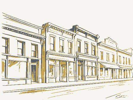
The Superior viaduct was replaced with the High Level Bridge in 1916. The 1912 Sanborn map indicated a drawbridge at Main Street. This earlier bridge was replaced with the Main Street high-level bridge, now part of the limited access Shoreway in 1939. Meanwhile, the Flats area developed as a commercial and industrial district. According to The Encyclopedia of Cleveland History, "In the second half of the 19th century the Flats were crowded with chemical factories and other industries." (p.408) Review of Sanborn maps for the historic district reveal an area that changed over time. The map from 1874 showed the east side of the Old River Road with a series of narrow individual buildings, street forming a continuous streetscape. The west side of the street was very similar to the street today with the buildings at 1330, 1322, 1310 and 1120-1240 Old River Road (#1, #2, #4, #5) in place.
The area that is Section number_ 8 - Page 5 United States Department of the Interior National Park Service CONTINUATION SHEET Cleveland, Cuyahoga Co., Ohio The 1896 Sanborn Map showed little change on the east side of the street, but the west side of the street had a large new building that infilled the entire space that is now the parking lot. A number of the The 1912 Sanborn Map illustrated the gradual replacement of small 19th century buildings on the east side of the street with larger commercial and industrial structures. A number of the buildings along Old River Road have housed and continue to house maritime-related businesses. In fact, in the 1896 Cleveland City Directory all of Cleveland's ship chandlers and sail lofts were located along Old River Road. A chart listing names and addresses of these businesses is included in this nomination.
Some of the most important maritime-related businesses included Hausheer & Sons, ship chandlers, located at 1220-1240 Old River Road (#5) from at least 1884 until the 1960s; Upson Walton, ship chandlers, located at 1220-1240 Old River Road (#5) from 1877-1890s and at 1310 Old River Road (#4) from the 1890s until 1963; and Samsel Marine Supply, which was located at 1310 Old River Road (#4) from 1964 until it moved into its present location at 1235 Old River Road (#6). According to the Ohio Historic Inventory form for 1220-1240 Old River Road (#5) the sail loft was "the largest room in he the Bethel Church and City Mission, which served sailors, and was located at 1322 Old River Road (#2) from the 1890s until the 1920s and at 1316 Old River Road (#3) until at least 1954. The remaining buildings reflect the industrial/warehouse nature of the district.
The buildings at 1295 (#8) later used for the storage of wire rope. J.E. Upson and J.W. Walton formed Upson-Walton in 1871. It became a major supplier of marine supplies such as wire rope, manila rope, tackle block and fittings for boats on the Great Lakes. The firm probably built the structure located at 1310 Old River Road (#4), as they were in business at that location from 1871 until 1963. Samsel Marine Supply took over the business in 1964 and operated in this building Samsel have provided marine supplies from this historic district continuously for over 140 years. The Old River Road Historic District includes a combination of vernacular and high-style buildings. The fire in 1952; and 1313 Old River Road (#10) was occupied by T. C. Spencer Co.
(paper products) and Architectural Significance Great Lakes devoted to sail making."(Johannesen,1975).Another maritime-related use in the district was until it moved across the street to the larger building at 1235 Old River Road(#6).Upson-Walton and and 1301 Old River Road (#9) were used by the U.S.Refining Company from the 1930s until it suffered a Section number 8 Page 6 currently a parking lot was largely an open lot at the time with a small building centered in the property. majority of the buildings are vernacular and utilitarian in design, with the 19" century elements of historic storefronts at 1313 and 1316 Old River Road (#1, #3).
The 20t century buildings reflect the utilitariar United States Department of the Interior National Park Service NATIONAL REGISTER OF HISTORIC PLACES Old River Road Historic District CONTINUATION SHEET Cleveland, Cuyahoga Co., Ohio nature of their original uses; examples are 1235 Old River Road (#6), 1285 Old River Road (#7); 1295 well-preserved late 19" century facades including the buildings at1330 and 1322 Old River Road (#1, Clearly the most outstanding buildings in the district from the standpoint of architecture are the two high- remarkable level of architectural integrity, with their original decorative cast iron storefront columns; upper story round-arched windows with decorative hoodmolds; and bracketed cornices. The building at 1310 Old River Road (#4) also retains its original round-arched six-over-six window sash.
The only building identified with a specific architect is located at 1235 Old River Road (#6). It was designed in 1916 by Christian, Schwarzenberg & Gaede for the Stone Brothers Warehouse. The Stone described the $160,000 building as a "fireproof five story flat slab acme system reinforced concrete Dealer, 8/20/1916) During this same period, from 1915-1917, Christian, Schwarzenberg & Gaede designed additions to the Federal Knitting Mills Building at 2860-2894 Detroit Avenue (NR 2001).The Higbee Company, one of Cleveland's major department stores, took over the building for use as a By the time the 1952 Sanborn map was prepared, the district appeared very much as it exists today. Given the amount of change that has occurred in downtown Cleveland during the last half-century, it is remarkable that the Old River Road Historic District has changed so little.
The area retains an intimate buildings reflecting nearly 100 years of history in Cleveland's Flats. The area also maintains integrity of location, setting, design, materials and association. scale with a two-lane street flanked by a nearly-continuous streetscape of one-to-five-story masonry construction.When the first section is completed the old structure occupying the remainder of the site will storage warehouse ...built in two sections so as not to interfere with the concern's business during Brothers were described in a Plain Dealer newspaper article as"woolen rag dealers.The article style Italianate buildings located at 1310 and 1220-1240 Old River Road(#4,#5). These buildings retain a Old River Road (#8) and 1313 Old River Road(#10).The district also contains several warehouse in the late1920s and continued to use it until at least the late20century. Page be razed.
Completion of the two sections, it is estimated, will take about a year. ..." (Cleveland Plain Section number 8 United States Department of the Interior National Park Service NATIONAL REGISTER OF HISTORIC PLACES Cleveland, Cuyahoga Co., Ohio Maritime-Related Businesses Historically Located along Old River Road, Cleveland, Ohio (based 1877/78 (CD) 1877/78, 1884/85 (CD) J. W. Grover & Son, Ship 1885/85 (CD) 1884/85 (CD) Hausheer & Sons, Ship 1922 (PB) J. A. Thompson, Marine 1935, 1939 (CD) Present use (located at 1310 Old River Road from 1964 until moved into this Burgert & Pomerene, 1896/97, 1905/06, 1910/11 (CD); 1871-1963 (NR) 1964 (NR) 1896/97 (CD) 1954 (CD) 1910/11 (CD) 1866/67 (CD) J.& J.R.
Wagner, Sail Lofts 1881/85 (IM) 1947, 1954, 1959 (CD) CD - City Directory PB - Plat Book IM - Insurance Map 1220-1240 Present Brokers Road Merchant name) Supplies Chandler building) River Road Dates of listings/Source Case Fish Company NR-National Register Nomination Commission Merchant Floating Bethel Church Grocer and Commission CONTINUATION SHEET Samsel Marine Supply Floating Bethel &City Mission on information found in city directories and insurance maps) Upson Walton, Ship Chandlers Name of Business/Type Old River Road Historic District Commission Merchant (no other Chandler and Sail Loft John Hemmater, Ship Chandler V. Swain's Sons, Sail Loft Charles E. Benham, Ship John U. Carr, Ship Chandler L.L. Davis, Commission Frank Morrison & Sons, Marine Karr & Mitchell, Ship Becker &Co., Ship 1905/06 (CD) S.B.
Conklin, Sail Lofts 1884/85, 1905/06 (CD); 1910 (IM); 1929, 1935, 1939, 1943-44, 1947, 1959 (CD) 1910/11 (CD); 1922 (PB) Robert Hanna & co., Wholesale Address Theodore Simmons, General Old River United States Department of the Interior NATIONAL REGISTER OF HISTORIC PLACES CONTINUATION SHEET Cleveland, Cuyahoga Co., Ohio 1330 Old River Road 1220-1240 Old River Road 1285 Old River Road Between 1310 and Becker, Thea Gallo. Cleveland 1796-1929. Chicago: Arcadia Publishing, 2004. Candon,George E. Yesterday's Cleveland. Miami: E. A. Seemann Publishing Cleveland City Directories. Johannesen, Eric. Samsel Rope and Marine Supply Company, National Register Nomination, 1974. Rolick, Drew. Research on history of Old River Road. Sanborn Fire Insurance Maps, 1874-78, 1896, 1912, 1932,1952. Van Tassel, David D. and Grabowski, John J. ed. The Encyclopedia of Cleveland History.
Bloomington, Indiana: Indiana University Press, 1987. Non-contributing Bibliography Yes Parking lot National Park Service List of Contributing and Non-Contributing Properties Inc., 1976 Old River Road Historic District Plain Dealer, "Storage Block Now Rising on W. 11th Street", August 20, 1916. Ohio Historic Inventory Forms, Ohio Historic Preservation Office.
Address Contributing or Building Number National Register Listed Section number 8 Page United States Department of the Interior National Park Service CONTINUATION SHEET Cleveland, Cuyahoga Co., Ohio Beginning at the southwest corner of the property at 1330 Old River Road; go north along the west at 1220-1240 Old River Road; go east along the north property line of 1220-1240 Old River Road and continue along the same line to the intersection with the property at 1235 Old River Road; go north along the west property line of 1235 Old River Road to the northwest corner of the property; go east along the north property line of 1235 Old River Road to the northeast corner of same property; go south along the east property line of all of the properties on the east side of Old River Road to the southeast corner of the continue in the same line to the intersection with 1322 Old River Road; go south along the east property line of 1322 and 1330 Old River Road to the point of beginning.
The boundaries of the Old River Road Historic District encompass a compact and cohesive streetscape of immediately east of the district; Settlers' Landing Park, immediately south of the district; the Cuyahoga River on the western edge of the district; and by substantially altered buildings on the west side of the street and a parking lot on the east side of the street at the northern end of the district.
Boundary Justification property lines of the properties on the west side of Old River Road to the northwest corner of the property Verbal Boundary Description property located at 1313 Old River Road;go west along the south boundary of 1313 Old River Road and development for a century.It is bounded by the Warehouse Historic District which ends at 1ot Street, NATIONAL REGISTER OF HISTORIC PLACES Old River Road Historic District mid-19" to mid-2o" century commercial and industrial buildings that represent the area's history and Old River Road Historic District, Cuyahoga County, OH 10. Geographical Data Acreage of Property approximately 4 acres 1 17 441282 4594099 - See continuation sheet. (Describe the boundaries of the property on a continuation sheet.) Boundary Justification (Explain why the boundaries were selected on a continuation sheet.) 11. Form Prepared By organization_ Benjamin D.
Rickey & Co street & number _telephone city or town Submit the following items with the completed form: A USGS map (7.5 or 15 minute series) indicating the property's location. Representative black and white photographs of the property. (Check with the SHPO or FPO for any additional items) Paperwork Reduction Act Statement: This information is being collected for applications to the National Register of Historic Places to nominate obtain a benefit in accordance with the National Historic Preservation Act, as amended (16 U.S.C. 470 et seq.). or any aspect of this form to the Chief, Administrative Services Division, National Park Service, P.0. Box 37127, Washington, DC 20013-7127; and the Office of Management and Budget, Paperwork Reductions Project (1024-0018), Washington, DC 20503. NPS Form 10-900 (Rev.
10-90) 5/05 name date Columbus Maps Photographs Zone Easting Northing Property Owner Continuation Sheets Additional Documentation UTM References Additional items (Complete this item at the request of the SHPO or FPO.) (Place additional UTM references ona continuation sheet) Verbal Boundary Description name/title Nancy Recchie/Historic Preservation Consultant 593 S. Fifth Street A Sketch map for historic districts and properties having large acreage or numerous resources. reviewing instructions, gathering and maintaining data, and completing and reviewing the form. Direct comments regarding this burden estimate OMB No. 1024-0018 state zip code National Park Service NATIONAL REGISTER OF HISTORIC PLACES CONTINUATION SHEET Cleveland, Cuyahoga Co., Ohio 593 South Fifth Street Columbus, Ohio 43206 1. View of Old River Road Historic District from St.
Clair Avenue, the south end of the historic district. 2. View looking north on Old River Road from the south end of the district. 3. View of 1330, 1322 and 1316 Old River Road from the south end of the district. 4. Corner detail of building at 1330 Old River Road. 5. View of 1322 and 1316 Old River Road. 7. Streetscape view of1322, 1316 and 1310 Old River Road. 9. Façade (east elevation) of 1310 Old River Road. 10. Storefront detail of 1310 Old River Road. 11. Streetscape view looking south along the east side of Old River Road from in front of 1271-1281 Old 12. View of river (west) elevation of 1310 Old River Road. 13. Streetscape view looking south on Old River Road from 1220-1240 Old River Road. Photographer: River Road. Date of Photographs: April 2005 Jeffrey Darbee Old River Road Historic District Benjamin D. Rickey & Co. 6.Entrance detail of building at 1316Old River Road.
Photo Views: United States Department of the Interior 8.View of 1310 Old River Road (Upson-Walton Building). Page 11 National Park Service NATIONAL REGISTER OF HISTORIC PLACES Old River Road Historic District CONTINUATION SHEET Cleveland, Cuyahoga Co., Ohio Section number_ Photos Page 12 14. Streetscape view looking north on Old River Road from 1271-1281 Old River Road. 15. View of 1220-1240 Old River Road. 16. Streetscape view looking north of the two buildings that form the north end of the historic district. 17. View of1235 Old River Road (Samsel Supply Co.). 18. Entrance detail of 1235 Old River Road. 21. View of 1295 Old River Road 22. Streetscape view looking north from 1310 Old River Road. 23. Streetscape view of east side of street looking south from 1310 Old River Road. 24. Streetscape view looking north along west side of Old River Road from St. Clair at the south end of 25.
View of the Old River Road Historic District from Settlers' Landing Park. The district is located along the east bank of the Cuyahoga River. The larger warehouse buildings behind the Old River Road Historic District are located in the Warehouse Historic District. 26. View of building on east side of Old River Road immediately north of the historic district. 27. View of building on east side of Old River Road outside the historic district. 28. View looking south toward 1235 Old River Road in the background. Building in the foreground is the historic district. outside the historic district. United States Department of the Interior DISTRICT BOUNDARIES 1330 ADORESSES 1 PHOTO VIEWS NOT TO SCALE Cuyahoga County, Ott 1310 1313 PARKING C CONTRIBUTING DUILOINES K1 24 OLO RIVER ROAD H.D. MAIN 1235 (LOOKiNG FROm SOUTH) UNITED STATES GEOLOGICAL SURVEY 438000m.E. ( 41°30 + R. 13 W.
42'30'l EUCLID 10 MI. LEVELAND 6 MI 25 West Basin Yacht Club LAKE EAST ERIE Herman Perkins 441282 4594099 DEPARTMENT OF THE INTERIOR ICLEVELA CUYAHOGACO.O H 466: R12 W1 6 LANE APPROX MEAN LAKE ELEV 571 LAKEWOOD (CITY HALL) 2.5 ZONE 17 TRANSIT Playground 62 MI.
440 680 4592 Cem AVE EDGE CLEUELAND 439 Dry Dock Monroe Brobklyn Oemt Lights Union 81°45 Sch EVALUATION/RETURN SHEET NAME : COMMENT WAIVER: N ABSTRACT/SUMMARY COMMENTS: - DISCIPLINE DOCUMENTATION see attached comments Y/N see attached SLR Y/N If a nomination is returned to the nominating authority, the TELEPHONE DATE RETURN 2/03/06 REVIEWER 1/26/06 MULTIPLE 12/21/05 RECOM./CRITERIA PERIOD: OTHER: PDIL: DATE RECEIVED: NATIONAL PARK SERVICE PROGRAM UNAPPROVED: NATIONAL REGISTER OF HISTORIC PLACES UNITED STATES DEPARTMENT OF THE INTERIOR DATE OF WEEKLY LIST: REASONS FOR REVIEW: DATE OF 16TH DAY: DATE OF 45TH DAY: STATE & COUNTY: OHIO, Cuyahoga APPEAL: N SLR DRAFT: N REJECT NATIONAL: SAMPLE: Sntered n the OLD RIVER CALABRIA OLO RIVER ROAO H.D. ALABRIA VEAL FINE IT LIAN FOODS PIZZA ITALIAN FOODS OLO RIVER ROAD H. D. CLEVELAND, CUYAMOGA CO., OH FURNITURE OLD RIVER ROAO H.D.
North FURNITURE Chap MADD LLO RIVER ROAO H. D. RHAUS OLD RIVER 241-0333 SATSED SUPPLY EO 241-9333 OLO RIVER ROAD H. D. 241-0333 CLEVELANO,COYA HOGA CO., OH WATERMARK CLEVELANO, CUYAMOGA CO, OH 1235 OLD RIVER Equipment Power 1285 SUPPLY CO SAMSEL FREE EVERY WEDNESDAY ONE WAYI FREE EVERY WEDNES 1187 4412824594099 CLEVELAND SOUTH QUADRANGLE DEPARTMENT OF THE INTERIOR GEOLOGICAL SURVEY OHIO-CUYAHOGA CO UNITED STATES 7.S MINUTE SERIES (TOPOGRAPHIC) CLEUELAND ZONE 17 CLEVELAND SOUTH, OHIO LAKES TOWING THE GREAT LAKES GROUPSM October 18, 2005 Via Certified Mail, Return Receipt Ms. Rachel M. Tooker State Historic Preservation Officer c/o National Register Staff Ohio Historic Preservation Office 567 East Hudson Street Columbus, Ohio 43211-1030 OBJECTION, Old River Road Historic District 1290 Old River Road, Cleveland, Cuyahoga County Dear Ms.
Tooker: We are the owners of the property located at 1290 Old River Road, Cleveland, Cuyahoga County, which is located within the proposed boundaries of an historic district now being considered by the Ohio Historic Site Preservation Advisory Board for nomination to the National Register of Historic Places. We strongly object to the listing of our property within the boundaries of an historic district because our land is unimproved property and we are contemplating to utilize it for the construction of a state-of-the-art office building or combination offfice/hotel. We do not wish to limit the design, or have the potential builders or the prospective buyers placed in a position where they would have to seek review or limit the nature or size of the project.
Other properties within the proposed historic district are not historic buildings at all and include high-rise apartments recently built with Federal assistance. We have no objection to placing certain select historic buildings on the National Register of Historic Places, but we have strong objections to the placing of vacant unimproved land on the National Register of Historic Places and limiting an owner's right to utilize that land for its "best use." Ronald C. Rasmus State of Ohio Sworn to before me this 18t* day of October 2005. Carolyn J. Oros State of Ohio, Cuyahoga County Commission Expires Aug. 23, 2006 1800 Terminal Tower, 50 Public Square, Cleveland, Ohio 44ll3-2274. (216) 621-4854, (800) 321-3663, Fax:(216) 621-76l6, www.thegreatlakesgroup.com RESPONSIBLE COMPANY President Sincerely, PROGRAM Notary Public County of Cuyahoga REC'D BY OHPO OCT 20 2005 100 CARRIER YECELENCE EST.
° THE GREAT REC'D BY OHPO DEC 0 2 2005 1285 Old River Road Cleveland, Ohio 44113 216-241-0333 Phone 216-241-3426 Fax Email kpetrick@samselsupply.com December 1, 2005 Survey and National Register Manager 567 East Hudson Street Columbus, Ohio 43211-1030 We are not opposed to having our buildings listed on the National Register. We seek Federal Funding for rehabilitation or some other need. We therefore, do not object to listing our buildings; 1235, 1285,1250, 1310, 1316, and 1322 Old River Road, Cleveland, Cuyahoga County, Ohio. Kathleen S. Petrick F. Michael Cc: Tom Yablonsky, Historic Warehouse District COMPANY Samsel President SUPPLY A Female Business Enterprise Mr. Stephen Gordon understand that limitations will not be placed on our properties unless we should VP Samsel Realty Company VP Samsel Supply Company Very truly yours, Dear Mr. Gordon,
 Block
Block