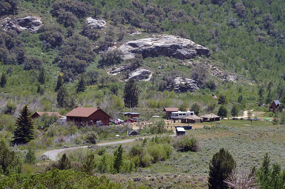
Listed on the National Register of Historic Places in 2007.
From the record
“The Lamoille Organization Camp, also known as Camp Lamoille and Elko Lion's Club Camp Lamoille, is a camping facility within the Ruby Mountains Ranger District of the Humboldt-Toiyabe National Forest. It is located in Lamoille Canyon, the largest valley of the Ruby Mountains, in Elko County, Nevada.”
Wikipedia article Lamoille Organization Camp, CC BY-SA 4.0.
One of 7 National Register listings published here for Elko County · listed in 2007 · category: District.
National Register reference number.07000553- the number the National Park Service assigned this property when it was listed, and the key its nomination file is catalogued under at the National Archives.
Fires near this property
29 since 1994
Regional context, not property-specific
evidence. The
federal wildfire occurrence database
lists 29 fires within 5 miles of Lamoille Organization Camp
between 1994 and 2020, burning about 10,452 acres in total. 9 started naturally. 1 was recorded as arson.
Distance is straight-line from the map coordinates, so a fire counted
here may appear on a neighbouring settlement's page as well.
Reported cause
Fires
Missing data/not specified/undetermined
11
Natural
9
Recreation and ceremony
5
Equipment and vehicle use
3
Arson/incendiarism
1
The most recent of
them, most recent first, with the day each was reported and the service
that recorded it.
Regional context, not property-specific
evidence. The federal mineral resources record lists
1 working within 5 miles of Lamoille Organization Camp: 1 occurrence.
None of them still produces. What was taken out: Stone, Crushed/Broken. Distance is straight-line from the
map coordinates, so a quarry counted here may appear on a neighbouring
settlement's page as well.
Regional context, not property-specific
evidence. The National Weather Service names
Lamoille, the town this property stands in, in 16 storm reports between 2003 and 2023: 6 flash flood, 4 debris flow, 2 thunderstorm wind, 2 flood.
No death or injury is recorded in these reports. Each account below is quoted exactly as the forecast office
filed it, from the NOAA Storm Events Database, and each date
opens the federal record of that event.
At least 15 different debris flows were caused by previous thunderstorms/heavy rain during the afternoon. Multiple reports came from the US Forest Service, Elko County Road Department, and Nevada Department of Transportation. USFS 660 will be closed until further notice. The height of debris flows is estimated to be between 4 and 8 feet within a 4-mile length of road.
Lamoille Creek swelled by snow melt flooded multiple residential properties and a few businesses in the town of Lamoille. For a brief time water flowed over Lamoille highway.
A 1.5 to 2 mile stretch of road was closed in Lamoille Canyon after a couple of debris flows occurred depositing fine sand, mud, and stones on the roadway. The road was closed for 3 hours for cleanup. The BURN2 RAWS station placed last summer near the Thomas Canyon Campground in Lamoille Canyon measured 0.57 inches of rain in 1 hour, from 15:45 LT to 16:45 LT. At 17:42LT a shift log entry referenced a phone call from a Forest Service representative that said there were some debris flows and that the road was closed. It was reopened at 20:45LT after crews cleared the road.
Lamoille Canyon Road (Forest Service Road 660) on the Humboldt-Toiyabe National Forests Mountain City-Ruby Mountains-Jarbidge Ranger District near Elko, Nevada, was closed to motorized vehicles from Thomas Canyon Campground to Roads End Trailhead due to multiple debris slides that occurred in Lamoille canyon dude to heavy rainfall. A portable RAWS site in the canyon measured 1.04 inches in an hour preceding the mudslides.
Moisture locked up in mountain snow began to melt in Lamoille Canyon from temperatures in the 60s and 70s. This caused large rocks and boulders to fall onto and close USFS-660 from the Powerhouse Group Picnic Area to Thomas Canyon Campground.
A USGS Hydrologist relayed through dispatch at approximately 19:15LT that there was a minor debris flow 1.9 miles above the Thomas Canyon Campground. The BURN2 station located at Thomas Canyon Campground recorded 0.15 in the previous 3 hours. Although the Lamoille #3 SNOTEL reported over 1 inch for the past 6 hours, with 0.7 inches reported ending at 1500LT and an additional 0.5 for the hour ending at 1600LT, although SNOTELs only report to the nearest tenth of an inch. Additionally, neither MRMS nor Dual Pol had been reporting anything significant over the Rubies since 1600LT. Although there was some debris on the road, the material was small enough that driving through it was manageable.
On the evening of August 12th, Lamoille Canyon received some brief periods of heavy rainfall. The BURN2 site located at the Thomas Canyon Campground in Lamoille Canyon recorded 0.34 inches that fell over a 15-minute span from 2100 to 2115LT. The area continued to get some more rain and ended up with 0.49 inches in 1 hour from 2100 to 2200 LT. Shortly thereafter a debris flow was reported in the area by a hydrologist from the USGS. Some water, mud, silt, and small rocks washed over the road depositing the silt and mud on the roadway. The hydrologist reiterated that 0.25 inches for 15 minutes or 1 inch/hr seem to be a good threshold for debris flows to occur.
Prolonged and heavy rainfall from showers parked over the Ruby Mountains produced radar estimated rainfall accumulations of 2 to 3 inches. This caused flash flooding and an area of debris flow including mud, sand, and rock over the roadway. It was estimated some spots of debris be 2 to 4 feet deep on the roadway per photos and first-hand reports.
National Weather Service employees reported three separate areas of water, mud, and debris, which flowed across the road in Lamoille Canyon. Most of the flash flooding was below Thomas Canyon campground.
Two off duty NWS employees saw small rope-like tornado approximately 5 miles north of the town of Lamoille. It appeared to be moving slowly towards the south.
No historic map-sheet match is published
for this property yet. That does not mean no map exists. This record needs
a coordinate-quality review before it can be joined to a sheet boundary.
Browse the county's mapped places while that work is
pending.
Listing record. National Park Service National Register of Historic Places, listed-properties dataset, current to 2026-05-22.
Map join. Address geocoded through the United States Census geocoder, then tested against the published boundary of every sheet in the USGS Historical Topographic Map Collection.
How this page is made. Listing fields come from federal records; map-sheet coverage is a labelled coordinate-to-boundary calculation, not a source-field claim.
Wildfire. Short, Karen C. 2022. Spatial wildfire occurrence data for the United States, 1992-2020 [FPA_FOD_20221014]. 6th Edition. Fort Collins, CO: Forest Service Research Data Archive. https://doi.org/10.2737/RDS-2013-0009.6 Collected with United States Government funding and usable without additional permissions or fees.
Mines and quarries. USGS Mineral Resources Data System (MRDS) https://mrdata.usgs.gov/mrds/ A work of the United States government, no copyright under 17 U.S.C. 105.
Storms. NOAA National Centers for Environmental Information, Storm Events Database https://www.ncei.noaa.gov/stormevents/ A work of the United States government, no copyright under 17 U.S.C. 105. Narratives are quoted verbatim from the National Weather Service report and are not edited or summarised.
 Block