
BlockBefore
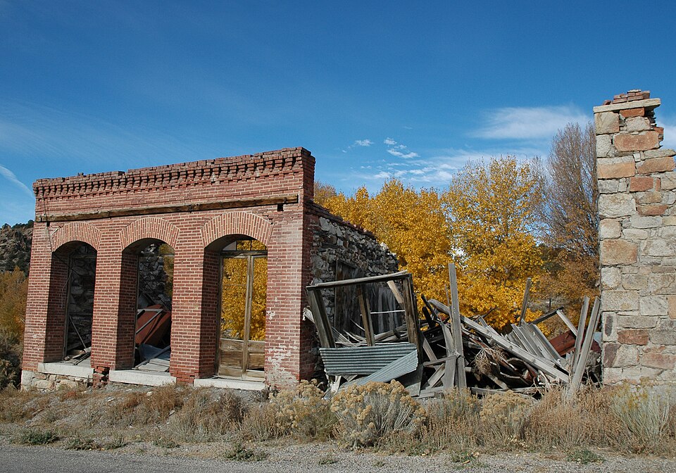
Photograph of Belmont
Photograph by Vivaverdi, CC BY 3.0. Via Wikimedia Commons.

Belmont

Listed on the National Register of Historic Places in 1972.

From the record

“Belmont is a ghost town in Nye County, Nevada, United States along former State Route 82. The town is a historic district listed in the National Register of Historic Places.”

Wikipedia article Belmont, Nevada, CC BY-SA 4.0.

One of 53 National Register listings published here for Nye County · listed in 1972 · category: District.

Sources: the Wikipedia article · the case file at the National Archives · the National Register database, National Park Service · the Wikipedia article

The listing

  • Address. 46 mi. NE of Tonopah off NV 82, Tonopah, 89045
  • When was it listed? June 1972
  • Category. district
  • Census division. Round Mountain
  • National Register reference number. 72000766 - the number the National Park Service assigned this property when it was listed, and the key its nomination file is catalogued under at the National Archives.

Fires near this property

3 since 1999

Regional context, not property-specific evidence. The federal wildfire occurrence database lists 3 fires within 5 miles of Belmont between 1999 and 2019, burning about 6 acres in total. 1 started naturally. None was recorded as arson. Distance is straight-line from the map coordinates, so a fire counted here may appear on a neighbouring settlement's page as well.

Reported cause Fires
Missing data/not specified/undetermined2
Natural1

The most recent of them, most recent first, with the day each was reported and the service that recorded it.

DateCause SizeReported by Name on the report
20 August 1999Naturalunder an acreBattle Mountain District OfficeNO7
13 May 2019Missing data/not specified/undetermined1.0 acresBattle Mountain District OfficeMEADOW
3 November 2017Missing data/not specified/undetermined4.4 acresHumboldt-Toiyabe National ForestSILVER CREEK

Every fire recorded in Nye County

Mines and quarries near this property

10 of 52 shown

Regional context, not property-specific evidence. The federal mineral resources record lists 52 workings within 5 miles of Belmont: 30 occurrences, 17 past producers, 3 unknowns, 1 prospect. 1 still produces. What was taken out: Silver, Gold, Copper, Tungsten. Distance is straight-line from the map coordinates, so a quarry counted here may appear on a neighbouring settlement's page as well.

Where SiteCommodity StatusRecorded
Arizona ClaimSilver, Copper, Antimony, Gold, Molybdenum, LeadPast ProducerCerargyrite, Molybdenite, Stetefeldite, Stromeyerite, Wulfenite
Barcelona MineSilver, Gold, Copper, Lead, Zinc, Molybdenum, Iron, Tungsten, Antimony, Mercury, Barium-BariteProducer1870
Bel ClaimsSilver, Lead, Copper, Zinc, Barium-Barite, Antimony, VanadiumOccurrenceVein
Bmt Claim GroupArsenic, Semiprecious GemstoneOccurrence
Combination MineSilver, AntimonyPast ProducerVein
El Dorado South MineSilver, Gold, Copper, Lead, Antimony, MolybdenumPast ProducerVein
Falcon ProspectTungsten, Gold, Copper, Lead, Zinc, BismuthPast Producer1956
Hot No. 1 MineUranium, Molybdenum, Manganese, Zinc, Beryllium, LeadOccurrenceMolybdenite, Torbernite, Wulfenite
Monarch RanchCopper, Cobalt, Chromium, NickelOccurrence
NBMG Sample Site 2039Silver, Lead, Copper, Molybdenum, Vanadium, Arsenic, Zinc, AntimonyOccurrence

Every working recorded in Nye County

Storms near this property

9 since 2006

Regional context, not property-specific evidence. The National Weather Service names Tonopah, the town this property stands in, in 9 storm reports between 2006 and 2021: 7 flash flood, 1 lightning, 1 flood. The reports record 1 death and 1 injury. Each account below is quoted exactly as the forecast office filed it, from the NOAA Storm Events Database, and each date opens the federal record of that event.

WhenEvent Place namedHarm What the report says
July 2006LightningTonopah1 killed, 1 hurtA 16 year old boy was struck and killed by lightning when he and his dad got out of their pickup truck to check the tires. His father was thrown to the ground when the lightning struck. The father was taken to the hospital for treatment and released. The boy's mother and sister stayed in the truck and were unharmed.
August 2017Flash FloodTonopah$5,000Flash flooding occurred in the town of Tonopah damaging some road shoulders. Damages are estimated.
July 2014Flash FloodTonopah$3,000Heavy rain from a thunderstorm caused flash flooding in the town of Tonopah. Water 1 to 1.5 feet deep flowed down main street. Water seeped into one business in downtown. Some asphalt was lifted at a Shell gas station. Damages are estimated.
July 2018Flash FloodTonopah$1,500Water to 18 deep was reported flowing across U.S. 95 southeast of of Tonopah. Minor road damage occurred.
July 2018Flash FloodTonopah$1,500Public reports via social media videos and pictures of street flooding in Tonopah.
August 2015Flash FloodTonopah$1,000Multiple reports were received of flooding on Route 89 near the Crescent Dunes solar energy plant. Damages are estimated.
August 2014Flash FloodTonopah$1,000Six inches of water were reported flowing down the shoulders and side roads in Tonopah. Estimated three feet of flowing water in dry washes. Damages estimated.
September 2014Flash FloodTonopah$1,000Heavy rain from thunderstorms sent water and debris across State Highway 376 from mile post 8 to 14. Damages estimated.
July 2021FloodTonopah-Law enforcement reported minor flooding at the corner of Main street and Cutting. An estimated 2-3 inches was flowing over the roadway per social media photo. Deputy estimated the flooding lasted 30 minutes, and no damage was reported. A nearby station (CMP23) recorded 0.79 inches of rain that fell in 40 minutes to 1 hours time.

Every storm recorded in Nye County

Map coverage status

No historic map-sheet match is published for this property yet. That does not mean no map exists. This record needs a coordinate-quality review before it can be joined to a sheet boundary. Browse the county's mapped places while that work is pending.

Sources for this property

National Archives recordThe nomination case file for reference 72000766 in Record Group 79.
Wikipedia articleCommunity-written account of this property, licensed CC BY-SA.
Nye CountyAll 53 listed properties in this county.

Provenance

  • Listing record. National Park Service National Register of Historic Places, listed-properties dataset, current to 2026-05-22.
  • Map join. Address geocoded through the United States Census geocoder, then tested against the published boundary of every sheet in the USGS Historical Topographic Map Collection.
  • How this page is made. Listing fields come from federal records; map-sheet coverage is a labelled coordinate-to-boundary calculation, not a source-field claim.
  • Wildfire. Short, Karen C. 2022. Spatial wildfire occurrence data for the United States, 1992-2020 [FPA_FOD_20221014]. 6th Edition. Fort Collins, CO: Forest Service Research Data Archive. https://doi.org/10.2737/RDS-2013-0009.6 Collected with United States Government funding and usable without additional permissions or fees.
  • Mines and quarries. USGS Mineral Resources Data System (MRDS) https://mrdata.usgs.gov/mrds/ A work of the United States government, no copyright under 17 U.S.C. 105.
  • Storms. NOAA National Centers for Environmental Information, Storm Events Database https://www.ncei.noaa.gov/stormevents/ A work of the United States government, no copyright under 17 U.S.C. 105. Narratives are quoted verbatim from the National Weather Service report and are not edited or summarised.