 Block
From the record
One of 4 National Register listings published here for Dewey County · listed in 2007 · category: Building · built in 1912.
Sources: the case file at the National Archives · the National Register database, National Park Service
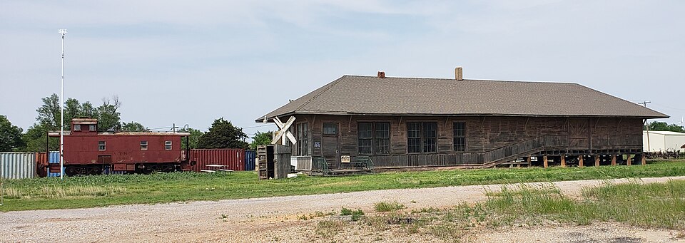
Built in 1912. Listed on the National Register of Historic Places in 2007.
One of 4 National Register listings published here for Dewey County · listed in 2007 · category: Building · built in 1912.
Sources: the case file at the National Archives · the National Register database, National Park Service
Regional context, not property-specific evidence. The federal wildfire occurrence database lists 1 fire within 5 miles of Vici M-K-T Depot in 2020, burning about 463 acres in total. None started naturally. None was recorded as arson. Distance is straight-line from the map coordinates, so a fire counted here may appear on a neighbouring settlement's page as well.
| Reported cause | Fires |
|---|---|
| Missing data/not specified/undetermined | 1 |
The most recent of them, most recent first, with the day each was reported and the service that recorded it.
| Date | Cause | Size | Reported by | Name on the report |
|---|---|---|---|---|
| 13 June 2020 | Missing data/not specified/undetermined | 463 acres | Oklahoma Division of Forestry | JEFFERY RANCH FIRE |
Regional context, not property-specific evidence. The federal mineral resources record lists 6 workings within 5 miles of Vici M-K-T Depot: 5 past producers, 1 prospect. None of them still produces. What was taken out: Sand and Gravel, Construction, Bentonite. Distance is straight-line from the map coordinates, so a quarry counted here may appear on a neighbouring settlement's page as well.
| Where | Site | Commodity | Status | Recorded |
|---|---|---|---|---|
| Bentonite Prospect | Bentonite | Prospect | ||
| Unknown Bentonite Pit | Bentonite, Sand and Gravel, Construction | Past Producer | ||
| Unknown Bentonite Pit | Bentonite, Sand and Gravel, Construction | Past Producer | ||
| Unknown | Sand and Gravel, Construction | Past Producer | ||
| Unknown Sand Pit | Sand and Gravel, Construction | Past Producer | ||
| Unknown Sand Pit | Sand and Gravel, Construction | Past Producer |
Regional context, not property-specific evidence. The National Weather Service names Vici, the town this property stands in, in 72 storm reports between 1993 and 2025: 48 hail, 21 thunderstorm wind, 2 tornado, 1 flash flood. No death or injury is recorded in these reports. Each account below is quoted exactly as the forecast office filed it, from the NOAA Storm Events Database, and each date opens the federal record of that event.
| When | Event | Place named | Harm | What the report says |
|---|---|---|---|---|
| June 2005 | Hail | Vici | $200,000 | Hail was an oblong stone which measured 2.5 inches by 3.5 inches. The large hail caused damage to vehicles along with damage to windows and roofs of homes. Tree limbs were also downed. |
| March 2007 | Thunderstorm Wind | Vici | $50,000 | Roof damage at Bank of Vici. Damage was reported to sheds, fences, and roof shingles. Tree limbs were also downed. |
| April 2001 | Thunderstorm Wind | Vici | $50,000 | A church steeple was blown off. |
| August 2025 | Thunderstorm Wind | Vici | $25,000 | The roof of a gas station canopy was blown off in the community of Vici. The location is approximate, and the event time is estimated from radar observations. |
| May 2007 | Tornado (EF1) | Vici | $15,000 | This is the continuation of the tornado that began in northeastern Ellis county. The tornado moved across the extreme northwest tip of Dewey county west and northwest of Vici before moving into Woodward County south of Sharon. The only reported damage in Dewey county was downed power lines. Monetary damages were estimated. |
| May 2018 | Thunderstorm Wind | Vici | $10,000 | An outbuilding was destroyed and damage occurred to street signs, a fence, mobile home siding, and a tin roof in and near Vici. Time estimated by radar. |
| July 2000 | Thunderstorm Wind | Vici | $10,000 | An 80-foot television tower was blown over. |
| July 1996 | Thunderstorm Wind | Vici | $10,000 | no account filed |
| April 2001 | Thunderstorm Wind | Vici | $4,000 | A sheet metal shed was destroyed. Road signs were downed, and roof shingle damage was sustained to several homes. |
| August 2011 | Thunderstorm Wind | Vici | $3,000 | A couple power poles were blown down. Monetary damages were estimated. |
| April 2012 | Hail | Vici | $1,500 | The back windshield of an automobile was shattered by the hail. |
| July 1998 | Thunderstorm Wind | Vici | $1,000 | no account filed |
| July 1996 | Thunderstorm Wind | Vici | $1,000 | no account filed |
| July 2005 | Thunderstorm Wind | Vici | $500 | Power lines were downed near the Ichem Plant. |
| July 2004 | Thunderstorm Wind | Vici | $100 | Tree limbs 2 inches in diameter were downed. |
| May 1998 | Thunderstorm Wind | Vici | $10 | no account filed |
| May 2018 | Thunderstorm Wind | Vici | - | No damage reported. |
| April 2015 | Hail | Vici | - | No damage reports. |
| April 2013 | Hail | Vici | - | Hail was accompanied by freezing rain. |
| October 2009 | Hail | Vici | - | The hail was reported by the County Commissioner. |
| September 2008 | Flash Flood | Vici | - | At least eight inches of water was running over Highway 60, making it impassable. |
| June 2005 | Hail | Vici | - | Hail was reported by KWTV Channel 9 in Oklahoma City. |
| June 2005 | Hail | Vici | - | Hail was reported by KWTV Channel 9 in Oklahoma City. |
| June 2005 | Hail | Vici | - | Hail was reported by KOCO Channel 5 in Oklahoma City. |
| June 2005 | Hail | Vici | - | Hail was reported by KFOR Channel 4 in Oklahoma City. |
| March 2004 | Tornado (F0) | Vici | - | This was a brief tornado with no known damage. |
| October 2021 | Hail | Vici | - | no account filed |
| January 2020 | Hail | Vici | - | no account filed |
| May 2018 | Hail | Vici | - | no account filed |
| April 2013 | Hail | Vici | - | no account filed |
| April 2012 | Hail | Vici | - | no account filed |
| April 2012 | Hail | Vici | - | no account filed |
| April 2012 | Hail | Vici | - | no account filed |
| April 2012 | Hail | Vici | - | no account filed |
| June 2011 | Hail | Vici | - | no account filed |
| August 2011 | Hail | Vici | - | no account filed |
| May 2010 | Hail | Vici | - | no account filed |
| May 2010 | Hail | Vici | - | no account filed |
| April 2009 | Hail | Vici | - | no account filed |
| May 2008 | Thunderstorm Wind | Vici | - | no account filed |
| March 2007 | Thunderstorm Wind | Vici | - | no account filed |
| March 2007 | Hail | Vici | - | no account filed |
| June 2005 | Hail | Vici | - | no account filed |
| June 2005 | Hail | Vici | - | no account filed |
| June 2005 | Hail | Vici | - | no account filed |
| July 2005 | Hail | Vici | - | no account filed |
| March 2004 | Hail | Vici | - | no account filed |
| March 2004 | Hail | Vici | - | no account filed |
| March 2004 | Hail | Vici | - | no account filed |
| May 2004 | Hail | Vici | - | no account filed |
| April 2004 | Hail | Vici | - | no account filed |
| April 2004 | Hail | Vici | - | no account filed |
| June 2004 | Thunderstorm Wind | Vici | - | no account filed |
| July 2004 | Thunderstorm Wind | Vici | - | no account filed |
| May 2003 | Hail | Vici | - | no account filed |
| July 2003 | Hail | Vici | - | no account filed |
| July 2003 | Hail | Vici | - | no account filed |
| April 2002 | Hail | Vici | - | no account filed |
| May 2002 | Hail | Vici | - | no account filed |
| May 2002 | Hail | Vici | - | no account filed |
No historic map-sheet match is published for this property yet. That does not mean no map exists. This record needs a coordinate-quality review before it can be joined to a sheet boundary. Browse the county's mapped places while that work is pending.
| National Archives record | The nomination case file for reference 07000911 in Record Group 79. |
| Dewey County | All 4 listed properties in this county. |