 Block
From the record
6 National Register listings published here.
Sources: the National Register database, National Park Service
52 topographic sheets cover 8 settlements here, and 6 properties are on the National Register of Historic Places.
6 National Register listings published here.
Sources: the National Register database, National Park Service
Every property in this county listed on the National Register of Historic Places, with the year it was listed and the federal nomination document.
| Photograph | Property | Type | Listed | Reference |
|---|---|---|---|---|
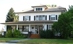 | Thomas M. Baldwin House | building | 1987 | 87001523 |
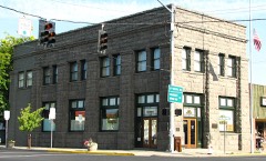 | Crook County Bank Building | building | 1991 | 91000802 |
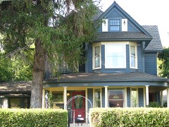 | Marion Reed Elliott House | building | 1989 | 89000049 |
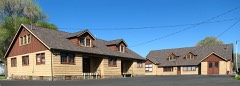 | Lamonta Compound-Prineville Supervisor's Warehouse | building | 1986 | 86000846 |
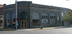 | Old First National Bank of Prineville, and Foster and Hyde Store | building | 1985 | 85003035 |
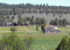 | Roba Ranch, The | building | 2007 | 07001159 |
Every wildfire the federal occurrence database records inside this county: 2,422 of them, burning about 64,605 acres. 1,801 started naturally and 23 were recorded as arson. Each settlement page carries the fires within five miles of it.
| Reported cause | Fires |
|---|---|
| Natural | 1801 |
| Recreation and ceremony | 307 |
| Missing data/not specified/undetermined | 113 |
| Debris and open burning | 68 |
| Equipment and vehicle use | 46 |
| Smoking | 33 |
| Arson/incendiarism | 23 |
| Other causes | 12 |
| Misuse of fire by a minor | 6 |
| Fireworks | 6 |
| Power generation/transmission/distribution | 4 |
| Firearms and explosives use | 3 |
The five largest, by the area the report gives. None of them was recorded as arson.
| Date | Cause | Size | Reported by | Name on the report |
|---|---|---|---|---|
| 23 August 2000 | Natural | 18,500 acres | Ochoco National Forest | HASH ROCK 1086 |
| 17 July 2014 | Natural | 9,848 acres | Ochoco National Forest | 0386 FOX |
| 18 July 2012 | Natural | 5,557 acres | Prineville District | BUCK CREEK 0280 |
| 9 September 2017 | Natural | 4,635 acres | Ochoco National Forest | 1135 PR DESOLATION |
| 16 August 2020 | Natural | 4,020 acres | Ochoco National Forest | FROG 0657 RS |
| 9 July 1994 | Natural | 3,000 acres | Prineville District | HORSEHEAVN |
| 13 July 2014 | Natural | 2,515 acres | Prineville District | 0297 CENTER |
| 29 September 2016 | Debris and open burning | 1,445 acres | Prineville District | 0624 EAST MAURY |
Every settlement page carries the fires within five miles of it - see the settlement index below.
The NOAA Storm Events Database holds 78 reports for this county, causing no deaths, no injuries and about $20,138,100 in recorded property damage. Each settlement page carries the reports that name it.
| Kind of event | Reports |
|---|---|
| Hail | 52 |
| Flash Flood | 7 |
| Heavy Rain | 7 |
| Thunderstorm Wind | 7 |
| Lightning | 4 |
| Flood | 1 |
The most serious of them, by death, then injury, then recorded damage. The accounts are quoted exactly as the forecast office filed them.
| When | Event | Place named | Harm | What the report says |
|---|---|---|---|---|
| June 2006 | Hail | Prineville | $20,000,000 | no account filed |
| May 2016 | Lightning | Goering Airstrip | $100,000 | Lightning started a house fire. Approx damage to house when fire was put out was around 100,000 dollars. |
| August 2019 | Flash Flood | Powell Butte | $20,000 | Slow moving thunderstorm with heavy rain and small hail resulted in flash flood. Flooding washed out portion of the road near Shumway and Busset. |
| August 2019 | Flash Flood | Prineville | $15,000 | House flooded with 4 feet of water in basement. Time estimated from radar. |
| August 2009 | Thunderstorm Wind | Prineville | $2,000 | Six to eight inch diameter tree branches were blown down across power lines causing power outage to southwest part of Prineville. |
| June 2004 | Thunderstorm Wind | Prineville | $1,000 | no account filed |
| August 2004 | Thunderstorm Wind | Prineville | $100 | no account filed |
| July 2024 | Thunderstorm Wind | Goering Airstrip | - | A trained spotter reported 4 large trees toppled in their neighborhood, with power having also gone out around 7:50pm on July 16th. |
| May 2023 | Flash Flood | Powell Butte | - | A Cocorahs station reported that heavy rainfall from training thunderstorms between 1700 to 1800 PDT resulted in localized flooding of fields and roads, with minor debris was left behind from receding flood waters. Relayed via a public internet community board, there were several reports from Brasada Ranch resort that homes, roads, and a golf course were damaged by the flash flooding. |
| May 2023 | Hail | Goering Airstrip | - | A trained spotter reported 0.88in hail at 1556L. |
| August 2021 | Hail | Goering Airstrip | - | A trained spotter in Crook county, OR reported quarter sized hail and that there had been damage to Aluminum siding. |
| May 2020 | Thunderstorm Wind | Prineville | - | Thirty foot tall tree blown down. |
| August 2019 | Hail | Prineville | - | Hail covering the ground with standing water on some flood prone roadways. |
| August 2019 | Hail | Powell Butte | - | Dime sized hail and torrential rain. |
| July 2012 | Hail | Prineville | - | Hail accompanied by wind gust to 40 mph. |
| January 2011 | Flood | Post | - | Ice jams which plugged culverts combined with rainfall and melting snow caused flooding. This prompted the closure of Conant Basin Road near Post and also Juniper Canyon Road. |
| June 2009 | Heavy Rain | Prineville | - | Water covering the road at the entrance to Prineville due to heavy rainfall. |
| July 2009 | Hail | Prineville | - | Hail 3/4 inch to 1 inch fell for 15 minutes. |
| August 2009 | Thunderstorm Wind | Prineville | - | Two inch diameter tree limbs blown down. Tree limb 1 foot in diameter also blown down. |
| July 2008 | Hail | Prineville | - | Hail size between dime and quarter size. |
| August 2008 | Hail | Prineville Reservoir | - | Large hail reported near Prineville Reservoir State Park. |
| August 2008 | Hail | Powell Butte | - | Reported by Prineville Police Department. |
| July 2006 | Hail | Prineville | - | Quarter sized hail producing dents in car. |
| August 2006 | Hail | Prineville Reservoir | - | Golfball hail near Roberts. |
| August 1999 | Hail | Prineville | - | Wind gusts up to 27 mph and frequent lightning accompanied this storm |
| May 1998 | Hail | Prineville | - | Thunderstorms moved through Crook County with strong wind, hail, and heavy rain. In the town of Post, 0.70 inches of rain fell in 50 minutes with 1/3 inch hail and wind gusts to 30 mph. In Prineville, 1/4 to 1 inch hail covered the ground to a depth of one inch in places, up to 1.15 inches of rain fell in 20 minutes, and the wind gusted to 60 mph. The road from Post to Prineville had rock and mud slides on it. |
| May 1998 | Hail | Prineville | - | A thunderstorm produced up to 1 inch hail, heavy rain, and wind gusts to between 50 and 60 mph. 1/2 inch hail covered the ground to a depth of one inch. 1.13 inches of rain fell in 20 minutes. Highway 26 east of Prineville had mud slides on it. |
| May 1998 | Heavy Rain | Prineville | - | Two inches of rain fell in 24 hours. |
| May 1998 | Heavy Rain | Post | - | 0.70 inches of rain fell in 50 minutes with 1/3 inch hail and wind gusts to 30 mph. |
| April 1998 | Lightning | Prineville | - | A thunderstorm moved through Deschutes, Crook, and Wheeler counties. Lightning caused a power pole to catch fire 3 miles northeast of Prineville. One quarter to one half inch hail covered the ground in eight miles north of Bend. Five eighths inch hail and 30 mph wind were reported in the town of Post. Heavy rain, strong wind, and pea-sized hail were reported in the town of Fossil. The storm moved through the town of Spray with heavy rain and strong wind gusting to 40-50 mph. |
| May 1998 | Heavy Rain | Prineville | - | A spotter reported 0.75 inches of rain in twenty minutes. Another spotter reported wind gusts to 45 mph with this thunderstorm. |
| June 1998 | Heavy Rain | Post | - | One inch of rain fell in ten minutes. |
| June 1998 | Heavy Rain | Prineville | - | Spotters in Prineville reported up to two inches of rain in 20 minutes, hail up to 1/2 inch, and wind gusts to 30 mph. |
| July 1998 | Heavy Rain | Prineville | - | Close to one inch of rain fell in half an hour causing local flooding. Highway 126 had water over it. |
| July 1998 | Hail | Prineville | - | A spotter 15 miles north of Prineville reported 3/4 inch hail and a heavy downpour that lasted 45 minutes. Allen Creek over flowed its banks. Some roads were washed out. |
| August 1997 | Hail | Prineville | - | A weather spotter at Prineville Resevoir State Park reported dime sized hail and up to an inch of rain in 30 minutes. Another spotter three miles north of Prineville Resevoir reported marble sized hail. |
| July 1997 | Lightning | Prineville | - | A lightning strike touched off a one and a half acre fire on a residential hillside in Prineville. Homeowners were able to fight the fire with garden hoses. No homes were damaged. |
| August 1997 | Hail | Prineville | - | Weather spotters reported hail between .5 and .75 of an inch...covering the ground in places. One spotter reported 0.70 of an inch of rain in twenty minutes. |
| May 1997 | Flash Flood | Powell Butte | - | A thunderstorm sent a 2-foot wall of water through several homes and fields soaking carpet and scattering silt over several hundered acres. The water also took out fences and caused damage to a road. |
| May 2016 | Hail | Powell Butte | - | no account filed |
| July 2014 | Hail | Prineville | - | no account filed |
| August 2013 | Hail | Powell Butte | - | no account filed |
| August 2013 | Hail | Prineville | - | no account filed |
| August 2013 | Hail | Prineville Arpt | - | no account filed |
| July 2012 | Hail | Prineville | - | no account filed |
| July 2012 | Hail | Foley Butte | - | no account filed |
| August 2009 | Hail | Prineville Arpt | - | no account filed |
| July 2009 | Hail | Prineville | - | no account filed |
| July 2009 | Hail | Prineville | - | no account filed |
| July 2008 | Hail | Prineville | - | no account filed |
| August 2008 | Hail | Prineville | - | no account filed |
| August 2008 | Hail | Prineville | - | no account filed |
| August 2008 | Hail | Prineville | - | no account filed |
| August 2008 | Hail | Powell Butte | - | no account filed |
| June 2006 | Hail | Prineville | - | no account filed |
| June 2006 | Hail | Powell Butte | - | no account filed |
| June 2006 | Hail | Powell Butte | - | no account filed |
| July 2006 | Hail | Prineville | - | no account filed |
| July 2006 | Hail | Prineville | - | no account filed |
| June 2006 | Hail | Prineville | - | no account filed |
The Survey's mineral resources record lists 298 workings inside this county. 76 still produce and 222 are closed or unrecorded. Each settlement page carries the workings within five miles of it.
| Commodity | Workings |
|---|---|
| Mercury | 94 |
| Sand and Gravel, Construction | 57 |
| Stone, Crushed/Broken | 39 |
| Stone | 33 |
| Gemstone | 22 |
| Gold | 13 |
| Uranium | 9 |
| Bentonite | 5 |
| Gypsum-Anhydrite | 4 |
| Pumice | 4 |
| Zeolites | 3 |
| Volcanic Materials | 3 |
| Clay | 2 |
| Iron | 2 |
The least common of them first, because a county's hundredth gravel pit says nothing its first ten did not.
| Where | Site | Commodity | Status | Recorded |
|---|---|---|---|---|
| Big Timber | Gold, Silver | Occurrence | ||
| Big Timber | Gold, Silver | Past Producer | ||
| Camp Creek Area | Geothermal | Producer | ||
| Mayflower Mine | Gold, Antimony, Copper, Lead, Mercury, Silver, Zinc | Past Producer | ||
| Mother Lode Mine | Mercury, Gold, Copper | Past Producer | 1899, 1906 | |
| Ochoco | Gold, Lead, Silver, Mercury, Antimony, Copper, Zinc | Past Producer | Chalcopyrite, Galena, Pyrite, Sphalerite, Tetrahedrite | |
| Oregon Grape | Gold, Silver, Copper | Occurrence | Chalcopyrite, Pyrite | |
| Oregon Grape | Gold, Silver, Copper | Past Producer | ||
| Suplee Limestone Area | Limestone, General | Unknown | ||
| Westerling | Mercury, Copper | Occurrence | 1930 | |
| White Swan | Mercury, Molybdenum, Zinc, Lead, Copper, Arsenic, Silver, Gold | Occurrence | Cinnabar | |
| Clay | Clay | Past Producer | ||
| Hampton Butte | Manganese | Occurrence | ||
| Hampton Butte Prospect | Manganese | Occurrence | 1931 | |
| Little Hay Creek Prospect | Chromium | Prospect | ||
| Lucky Strike | Semiprecious Gemstone | Producer | ||
| Rainbow Ridge Mine | Semiprecious Gemstone | Producer | ||
| Suplee Area Iron | Iron | Occurrence | ||
| Suplee Area Iron | Iron | Occurrence | ||
| Taylor Ranch Mine | Chromium | Past Producer | 1938, 1940 | |
| Unnamed Pit | Clay | Producer | ||
| Crooked River Tuff | Volcanic Materials | Past Producer | ||
| Evergreen Bentonite, Incpit | Zeolites | Past Producer | ||
| Oregon Emerald Tuff Quarry | Volcanic Materials | Past Producer | ||
| Sage Hollow Mining Inc. | Volcanic Materials | Past Producer | ||
| Steins Pillar Area Zeolite | Zeolites | Occurrence | ||
| Steins Pillar Area Zeolite | Zeolites | Unknown | ||
| Crook County Cinder Pit | Pumice | Producer | ||
| Grassy Butte Cinder Pit | Pumice | Producer | ||
| Gypsite Occurence | Gypsum-Anhydrite | Occurrence | ||
| Gypsite Occurence | Gypsum-Anhydrite | Unknown | ||
| Prineville Reservoir Community Pit | Pumice | Producer | ||
| Unnamed Pit | Pumice | Producer | ||
| White Swan Gypsum | Gypsum-Anhydrite | Unknown | ||
| White Swan Gypsun | Gypsum-Anhydrite | Occurrence | ||
| Central Oregon Bentonite | Bentonite | Past Producer | ||
| Central Oregon Bentonite | Bentonite | Producer | ||
| Evergreen Bentonite Pit | Bentonite | Producer | ||
| Prineville Bentonite | Bentonite | Past Producer | ||
| Prineville Bentonite | Bentonite | Unknown | ||
| Bear Creek | Uranium | Unknown | ||
| Bear Creek Butte Uranium | Uranium | Unknown | ||
| Bear Creek Uranium | Uranium | Occurrence | 1955 | |
| Bear Creek Uranium | Uranium | Prospect | ||
| Games Guide Group | Uranium | Occurrence | ||
| Games Guide Group | Uranium | Unknown | ||
| Powell Butte Uranium | Mercury, Uranium | Occurrence | 1955 | |
| Powell Butte Uranium | Uranium, Mercury | Unknown | ||
| Sage Hollow Mining Inc | Uranium | Occurrence | Uranophane | |
| Bear Creek Project | Gold | Occurrence | ||
| Bear Creek Project | Gold | Past Producer | ||
| Bear Creek Project | Gold | Prospect | ||
| Blevins Prospect | Mercury, Gold | Prospect | ||
| Gold Prospect | Gold | Occurrence | ||
| Last Chance | Gold | Occurrence | ||
| Little Chance | Gold | Occurrence | ||
| Little Chance Mine | Gold | Occurrence | ||
| Scissors Creek Area Placers | Gold | Past Producer | ||
| Scissors Creek Area Placers | Gold | Past Producer | ||
| Bear Springs | Gemstone | Past Producer | ||
| Bear Springs | Gemstone | Producer | ||
| Fly Ridge | Gemstone | Past Producer | ||
| Fly Ridge | Gemstone | Producer | ||
| Lavish Lady | Gemstone | Past Producer | ||
| Lavish Lady | Gemstone | Producer | ||
| Little Smaky | Gemstone | Past Producer | ||
| Little Smaky | Gemstone | Producer | ||
| Lucky Strike | Gemstone | Past Producer | ||
| Lucky Strike Mine | Gemstone | Past Producer | ||
| Ochoco Agate Mining Claim | Gemstone | Producer | ||
| Ochoco Mining Agate Cl | Gemstone | Past Producer | ||
| Sleeping Beauty | Gemstone | Past Producer | ||
| Sleeping Beauty | Gemstone | Producer | ||
| Smoky Blue | Gemstone | Past Producer | ||
| Smoky Blue | Gemstone | Producer | ||
| Tamarack | Gemstone | Past Producer | ||
| Tamarak | Gemstone | Producer | ||
| Two Dogs | Gemstone | Past Producer | ||
| Two Dogs | Gemstone | Producer | ||
| White Fir | Gemstone | Past Producer | ||
| White Fir | Gemstone | Producer | ||
| Basalt Quarry | Stone | Past Producer | ||
| Basalt Quarry | Stone | Past Producer | ||
| Basalt Quarry | Stone | Past Producer | ||
| Basalt Quarry | Stone | Past Producer | ||
| Basalt Quarry | Stone | Past Producer | ||
| Basalt Quarry | Stone | Past Producer | ||
| Brooks Resources | Stone | Past Producer | ||
| Buckner Quarry | Stone | Past Producer | ||
| Crooked River Tuff | Stone | Past Producer | ||
| Fox Canyon Pit | Stone | Past Producer | ||
| Jageye | Stone | Past Producer | ||
| Jagi Pit | Stone | Past Producer | ||
| Jagi Pit | Stone | Producer | ||
| Layton | Stone | Past Producer | ||
| Ochoco Highway | Stone | Past Producer | ||
| Ochoco Highway | Stone | Past Producer | ||
| Oregon Emerald Tuff Quarry | Stone | Past Producer | ||
| Paulina | Stone | Past Producer | ||
| Quarry | Stone | Past Producer | ||
| Quarry | Stone | Past Producer | ||
| Quarry | Stone | Past Producer | ||
| Quarry | Stone | Past Producer | ||
| Quarry | Stone | Past Producer | ||
| Quarry | Stone | Past Producer | ||
| Quarry | Stone | Past Producer | ||
| Quarry | Stone | Past Producer | ||
| Quarry | Stone | Past Producer | ||
| Rafter #2 | Stone | Past Producer | ||
| Rickman | Stone | Past Producer | ||
| Rocky Canyon | Stone | Past Producer | ||
| Suplee Limestone Area | Stone | Past Producer | ||
| Weberg Pit | Stone | Past Producer | ||
| Weberg Pit | Stone | Past Producer | ||
| Brooks Resources | Stone, Crushed/Broken | Producer | ||
| Buckner Quarry | Stone, Crushed/Broken | Producer | ||
| Congleton Pit | Stone, Crushed/Broken | Producer | ||
| Crook County #2 | Stone, Crushed/Broken | Producer | ||
| Crook County Cinder Pit | Stone, Crushed/Broken | Past Producer | ||
| Fox Canyon Pit | Stone, Crushed/Broken | Past Producer | ||
| Hudspeth | Stone, Crushed/Broken | Producer | ||
| Jageye Pit | Stone, Crushed/Broken | Producer | ||
| Jones-McKay Pit | Stone, Crushed/Broken | Producer | ||
| Juniper Canyon | Stone, Crushed/Broken | Producer | ||
| Layton | Stone, Crushed/Broken | Producer | ||
| Lone Pine Quarry | Stone, Crushed/Broken | Producer | ||
| Ochoco Hgihway Pit | Stone, Crushed/Broken | Producer | ||
| Ochoco Highway Pit | Stone, Crushed/Broken | Producer | ||
| Paulina Pit | Stone, Crushed/Broken | Producer | ||
| Prinevile Reservoir | Stone, Crushed/Broken | Past Producer | ||
| Rafter #2 | Stone, Crushed/Broken | Producer | ||
| Rickman Pit | Stone, Crushed/Broken | Producer | ||
| Rocky Canyon | Stone, Crushed/Broken | Producer | ||
| Stahancyk | Stone, Crushed/Broken | Producer | ||
| Unnamed Pit | Stone, Crushed/Broken | Producer | ||
| Unnamed Pit | Stone, Crushed/Broken | Producer | ||
| Unnamed Pit | Stone, Crushed/Broken | Producer | ||
| Unnamed Pit | Stone, Crushed/Broken | Producer | ||
| Unnamed Pit | Stone, Crushed/Broken | Producer | ||
| Unnamed Pit | Stone, Crushed/Broken | Producer | ||
| Unnamed Pit | Stone, Crushed/Broken | Producer | ||
| Unnamed Pit | Stone, Crushed/Broken | Producer | ||
| Unnamed Pit | Stone, Crushed/Broken | Producer | ||
| Unnamed Pit | Stone, Crushed/Broken | Producer | ||
| Unnamed Pit | Stone, Crushed/Broken | Producer | ||
| Unnamed Pit | Stone, Crushed/Broken | Producer | ||
| Unnamed Pit | Stone, Crushed/Broken | Producer | ||
| Unnamed Pit | Stone, Crushed/Broken | Producer | ||
| Unnamed Pit | Stone, Crushed/Broken | Producer | ||
| Unnamed Pit | Stone, Crushed/Broken | Producer | ||
| Unnamed Pit | Stone, Crushed/Broken | Producer | ||
| Weberg Pit | Stone, Crushed/Broken | Producer | ||
| Weberg Pit | Stone, Crushed/Broken | Producer | ||
| Bear Creek | Sand and Gravel, Construction | Past Producer | ||
| Camp Creek | Sand and Gravel, Construction | Past Producer | ||
| Camp Creek | Sand and Gravel, Construction | Producer | ||
| Congleton | Sand and Gravel, Construction | Past Producer | ||
| Crook County #1 | Sand and Gravel, Construction | Past Producer | ||
| Crook County #1 | Sand and Gravel, Construction | Past Producer | ||
| Crook County #3 | Sand and Gravel, Construction | Unknown | ||
| Crook County #4 | Sand and Gravel, Construction | Past Producer | ||
| Crook County #4 | Sand and Gravel, Construction | Producer | ||
| Evergreen Bentonite Mill | Sand and Gravel, Construction | Producer | ||
| Grassy Butte Cinder Pit | Sand and Gravel, Construction | Past Producer | ||
| Gravel Pit | Sand and Gravel, Construction | Past Producer | ||
| Gravel Pit | Sand and Gravel, Construction | Past Producer | ||
| Gravel Pit | Sand and Gravel, Construction | Past Producer | ||
| Gravel Pit | Sand and Gravel, Construction | Past Producer | ||
| Gravel Pit | Sand and Gravel, Construction | Past Producer | ||
| Gravel Pit | Sand and Gravel, Construction | Past Producer | ||
| Gravel Pit | Sand and Gravel, Construction | Past Producer | ||
| Griffin Site | Sand and Gravel, Construction | Past Producer | ||
| Griffin Site | Sand and Gravel, Construction | Producer | ||
| Hudspeth | Sand and Gravel, Construction | Past Producer | ||
| Jones-McKay | Sand and Gravel, Construction | Past Producer | ||
| Jungle Creek Pit | Sand and Gravel, Construction | Past Producer | ||
| Juniper Canyon | Sand and Gravel, Construction | Past Producer | ||
| Lone Pine Quarry | Sand and Gravel, Construction | Past Producer | ||
| Lost Creek | Sand and Gravel, Construction | Past Producer | ||
| Lost Creek Pit | Sand and Gravel, Construction | Producer | ||
| Modular Crushing #2 | Sand and Gravel, Construction | Past Producer | ||
| Modular Crushing #2 | Sand and Gravel, Construction | Producer | ||
| Modular Crushing Co | Sand and Gravel, Construction | Past Producer | ||
| Modular Crushing Co. | Sand and Gravel, Construction | Past Producer | ||
| Mp 12.5 Ochoco Highway | Sand and Gravel, Construction | Past Producer | ||
| Mp 12.5 Ochoco Highway | Sand and Gravel, Construction | Producer | ||
| Mp 23.6 Ochoco Highway | Sand and Gravel, Construction | Past Producer | ||
| Mp 23.6 Ochoco Highway | Sand and Gravel, Construction | Producer | ||
| O'Neal Sand and Gravel Co | Sand and Gravel, Construction | Producer | ||
| O'Neil Pit & Plant | Sand and Gravel, Construction | Past Producer | ||
| Pieratt | Sand and Gravel, Construction | Past Producer | ||
| Prineville Sand & Gravel | Sand and Gravel, Construction | Past Producer | ||
| Prineville Sand& Gravel | Sand and Gravel, Construction | Past Producer | ||
| Quens Lease | Sand and Gravel, Construction | Past Producer | ||
| Quens Lease | Sand and Gravel, Construction | Producer | ||
| Riverside Ranch | Sand and Gravel, Construction | Past Producer | ||
| Riverside Ranch Pit | Sand and Gravel, Construction | Producer | ||
| Stahancyk Grizzly Mtn Rock Prod | Sand and Gravel, Construction | Past Producer | ||
| Tachman | Sand and Gravel, Construction | Past Producer | ||
| Unnamed Pit | Sand and Gravel, Construction | Producer | ||
| Unnamed Pit | Sand and Gravel, Construction | Producer | ||
| Unnamed Pit | Sand and Gravel, Construction | Producer | ||
| Unnamed Pit | Sand and Gravel, Construction | Producer | ||
| Unnamed Pit | Sand and Gravel, Construction | Producer | ||
| Walter J Osborne | Sand and Gravel, Construction | Past Producer | ||
| Walter J. Osborne | Sand and Gravel, Construction | Past Producer | ||
| Widow Creek Pit | Sand and Gravel, Construction | Past Producer | ||
| Widow Creek Pit | Sand and Gravel, Construction | Producer | ||
| Williams Gravel Pit | Sand and Gravel, Construction | Producer | ||
| Williams Pit | Sand and Gravel, Construction | Past Producer | ||
| Allison | Mercury | Occurrence | 1931 | |
| Allison Prospect | Mercury | Prospect | ||
| Amity Mine | Mercury | Past Producer | 1929, 1930 | |
| Amity Mine | Mercury | Past Producer | 1930 | |
| Amundson Mercury | Mercury | Occurrence | Cinnabar | |
| Amundson Mercury | Mercury | Prospect | ||
| Barnes Butte | Mercury | Past Producer | 1940 | |
| Barnes Butte Mine | Mercury | Past Producer | 1940, 1941 | |
| Beale | Mercury | Occurrence | ||
| Beale Prospect | Mercury | Unknown | ||
| Blevins | Mercury | Occurrence | 1931 | |
| Blue Ridge | Mercury | Past Producer | 1930 | |
| Blue Ridge Mine | Mercury | Past Producer | 1930 | |
| Botz | Mercury | Occurrence | 1931 | |
| Botz Prospect | Mercury | Prospect | ||
| Bryam-Oscar | Mercury | Past Producer | 1932 | |
| Byram-Oscar Mine | Mercury | Past Producer | 1932, 1935 | |
| Champion | Mercury | Past Producer | 1930 | |
| Champion Mine | Mercury | Past Producer | 1930, 1934 | |
| Cinnabar | Mercury | Past Producer | ||
| Cinnabar | Mercury | Unknown | ||
| Connant Basin | Mercury | Occurrence | ||
| Connant Basin | Mercury | Unknown | ||
| Devil's Food | Mercury | Occurrence | 1932 | |
| Devil's Food Prospect | Mercury | Prospect | ||
| Eickemeyer Prospect | Mercury | Occurrence | Cinnabar | |
| Eickemeyer Prospect | Mercury | Prospect | ||
| Gray Prairie | Mercury | Occurrence | 1930 | |
| Gray Prairie Prospect | Mercury | Prospect | ||
| Hudson | Mercury | Occurrence | 1939 | |
| Hudson Prospect | Mercury | Prospect | ||
| Ideal | Mercury | Occurrence | Cinnabar, Limonite | |
| Ideal Cinnabar | Mercury | Occurrence | ||
| Ideal Cinnabar Mine | Mercury | Prospect | ||
| Ideal Prospect | Mercury | Prospect | ||
| Independent | Mercury | Occurrence | Cinnabar, Pyrite | |
| Independent Prospect | Mercury | Prospect | ||
| Israel | Mercury | Occurrence | 1931 | |
| Israel Prospect | Mercury | Prospect | ||
| Jimmy Ann | Mercury | Past Producer | 1927 | |
| Joe Dandy | Mercury | Occurrence | ||
| Joe Dandy | Mercury | Prospect | ||
| Johnson | Mercury | Occurrence | Cinnabar | |
| Johnson Prospect | Mercury | Prospect | ||
| Kidnap Spring | Mercury | Occurrence | 1931 | |
| Kidnap Spring Prospect | Mercury | Prospect | ||
| Little Hay Creek | Mercury | Occurrence | 1930 | |
| Log Cabin | Mercury | Prospect | ||
| Lost Cinnabar | Mercury | Producer | 1930 | |
| M.A.S. No 1,2,3,&,4 | Mercury | Occurrence | ||
| M.A.S. Nos. 1-4 | Mercury | Past Producer | ||
| Maury Mountain Mines | Mercury | Past Producer | 1930, 1932 | |
| Maury Mountains Mine | Mercury | Past Producer | 1930 | |
| Moore | Mercury | Occurrence | Cinnabar | |
| Moore Prospect | Mercury | Prospect | ||
| Mother Lode | Mercury | Past Producer | 1902 | |
| New Deal | Mercury | Occurrence | ||
| New Deal | Mercury | Prospect | ||
| Ontko | Mercury | Occurrence | 1930 | |
| Ontko Prospect | Mercury | Prospect | ||
| Orion Mining Co. | Mercury | Occurrence | Cinnabar | |
| Oronogo | Mercury | Past Producer | 1927 | |
| Oronogo Mine | Mercury | Past Producer | ||
| Peaslee Creek | Mercury | Occurrence | Cinnabar | |
| Peaslee Creek Prospect | Mercury | Prospect | ||
| Pinkey | Mercury | Occurrence | 1938 | |
| Pinkey Prospect | Mercury | Prospect | ||
| Platner | Mercury | Past Producer | 1930 | |
| Platner Mine | Mercury | Past Producer | 1930, 1939 | |
| Red Warrior | Mercury | Occurrence | ||
| Red Warrior | Mercury | Unknown | ||
| Round Mountain | Mercury | Past Producer | 1933 | |
| Round Mountain Prospect | Mercury | Past Producer | ||
| Salt Creek | Mercury | Occurrence | 1940 | |
| Salt Creek Prospect | Mercury | Prospect | ||
| Staley Mine | Mercury | Past Producer | 1927, 1928 | |
| Strickland Butte Mine | Mercury | Past Producer | 1940 | |
| Strickland Butte Mine | Mercury | Past Producer | ||
| Taylor Ranch | Mercury | Past Producer | 1938 | |
| Towner | Mercury | Past Producer | ||
| Viewpoint | Mercury | Occurrence | ||
| Viewpoint Prospect | Mercury | Unknown | ||
| Watson | Mercury | Past Producer | Cinnabar | |
| Watson Prospect | Mercury | Prospect | ||
| Wesserling | Mercury | Occurrence | ||
| Wesserling Prospect | Mercury | Prospect | ||
| Wildfire Cinnabar | Mercury | Occurrence | ||
| Wildfire Cinnabar | Mercury | Prospect |
Named settlements recorded in the Geographic Names Information System, each with the topographic sheets covering it. Villages, hamlets and abandoned places alike. Each is shown with the nearest named watercourse or landform and the survey quadrangle it falls on.
Powell Butte census division · 97760 · On Lone Pine Creek · O'Neil quadrangle
15 sheets, 1926 to 1980
Crooked River census division · 97754 · Stearns Butte quadrangle
9 sheets, 1955 to 1988
Crooked River census division · 97751 · Near X X Ridge · Paulina quadrangle
14 sheets, 1932 to 1992
Crooked River census division · 97752 · On Horse Heaven Creek · Post quadrangle
11 sheets, 1951 to 1992
Prineville census division · 97754 · Near Putnam Gulch · Prineville quadrangle
10 sheets, 1955 to 1992
Crooked River census division · 97751 · Near Colpitts Butte · Suplee quadrangle
14 sheets, 1932 to 1992