 Block
From the record
4 National Register listings published here.
Sources: the National Register database, National Park Service
37 topographic sheets cover 15 settlements here, and 4 properties are on the National Register of Historic Places.
4 National Register listings published here.
Sources: the National Register database, National Park Service
Every property in this county listed on the National Register of Historic Places, with the year it was listed and the federal nomination document.
| Photograph | Property | Type | Listed | Reference |
|---|---|---|---|---|
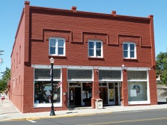 | S. B. Barker Building | building | 1989 | 89000053 |
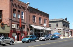 | Condon Commercial Historic District | district | 1998 | 98000609 |
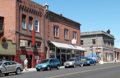 | Condon Commercial Historic District (Boundary Increase) | district | 2001 | 01000493 |
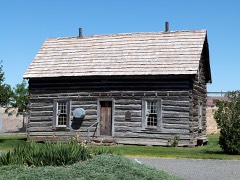 | Silas A. Rice Log House | building | 1991 | 91001556 |
Every wildfire the federal occurrence database records inside this county: 70 of them, burning about 242,430 acres. 35 started naturally and none was recorded as arson. Each settlement page carries the fires within five miles of it.
| Reported cause | Fires |
|---|---|
| Natural | 35 |
| Missing data/not specified/undetermined | 14 |
| Equipment and vehicle use | 8 |
| Debris and open burning | 5 |
| Recreation and ceremony | 3 |
| Power generation/transmission/distribution | 1 |
| Misuse of fire by a minor | 1 |
| Fireworks | 1 |
| Railroad operations and maintenance | 1 |
| Smoking | 1 |
The five largest, by the area the report gives. None of them was recorded as arson.
| Date | Cause | Size | Reported by | Name on the report |
|---|---|---|---|---|
| 17 August 2018 | Natural | 54,221 acres | Prineville District | STUBBLEFIELD |
| 21 July 2016 | Missing data/not specified/undetermined | 31,848 acres | Prineville District | 0353 SCOTT CANYON |
| 29 July 2014 | Equipment and vehicle use | 25,937 acres | Prineville District | 0539 SNIPTION |
| 17 August 2018 | Missing data/not specified/undetermined | 23,600 acres | South Gilliam County Rural Fire Protection District | SEALE 1045 RN |
| 22 July 2000 | Missing data/not specified/undetermined | 19,650 acres | Prineville District | HORN BUTTE |
| 4 August 1994 | Natural | 13,800 acres | Prineville District | THIRTYMILE |
| 21 July 2017 | Equipment and vehicle use | 9,357 acres | Prineville District | 0594 HORN BUTTE |
| 25 June 1994 | Recreation and ceremony | 9,006 acres | Prineville District | FERRYCANYN |
Every settlement page carries the fires within five miles of it - see the settlement index below.
The NOAA Storm Events Database holds 23 reports for this county, causing no deaths, no injuries and about $20,059,500 in recorded property damage. Each settlement page carries the reports that name it.
| Kind of event | Reports |
|---|---|
| Hail | 11 |
| Thunderstorm Wind | 6 |
| Wildfire | 2 |
| Flash Flood | 2 |
| Tornado | 1 |
| Heavy Rain | 1 |
The most serious of them, by death, then injury, then recorded damage. The accounts are quoted exactly as the forecast office filed them.
| When | Event | Place named | Harm | What the report says |
|---|---|---|---|---|
| July 1995 | Hail | not stated | $20,000,000 | no account filed |
| April 2012 | Flash Flood | Mayville | $50,000 | Flash flood washed out Armstrong Road and Thirty mile road and moved large amounts of debris including large boulders. A fiber optic communications line was cut which caused phone outage for hundreds of customers. A cow and calf were swept away in the flash flood. |
| August 2003 | Flash Flood | Condon | $7,000 | A thunderstorm produced very heavy rain in a short period of time in Condon. A cooperative observer reported 1.12 inches of rain in about 15 minutes, which led to flash flooding. The flash flood resulted in flooding on Main Street, while mud, rocks, and water spilled over roadways inside, and in the vicinity of Condon, flooding some buildings, and shorting out power lines. The basement of the North Central Education Service District Building collected water that rain gutters couldn't contain. Gilliam county Road Department Employees aided in cleaning and repairing county roads. The property damage from this event is estimated at $7,000. |
| April 1957 | Tornado (F0) | not stated | $2,500 | no account filed |
| August 2024 | Thunderstorm Wind | Quinton | - | ODOT sensors at Blalock Canyon and LePage Park measured a wind gust of 58 and 63 mph, respectively. |
| May 2020 | Thunderstorm Wind | Condon | - | Tree down and damage to a home. |
| June 2019 | Hail | Condon | - | Hailstones up to the size of nickels were reported with accumulations of up to 2 inches on the ground. |
| August 2011 | Thunderstorm Wind | Clem | - | Thunderstorm winds accompanied by blowing dust which reduced visibility to 200 feet briefly. |
| March 2011 | Thunderstorm Wind | Mikkalo | - | Weather station near the Ajax airstrip recorded gust to 62 mph. |
| May 2010 | Hail | Lonerock | - | Hail ranging in size from nickel to quarter fell for 10 minutes and covered the ground. Heavy rainfall accompanied the hail. |
| May 2006 | Thunderstorm Wind | Condon | - | Power lines down across northern half of county between Arlington and Condon. |
| July 1998 | Wildfire | Central Portion | - | Lightning caused a range fire about ten miles north of Condon on the evening of July 10. That fire was put out a few hours later then lightning struck again and started a wild fire that lasted into the evening of the 11th. Four caterpillars, a road grader, a spray plane, and numerous volunteers helped control the fire. |
| July 1998 | Wildfire | Blalock | - | A range fire started near Blalock when a bird caused an arch between two power lines. In the process of resetting the power, a line sparked which caused another fire that eventually burnt a couple hundred acres of wheat, several outbuildings and grain storage facilities. |
| July 1998 | Heavy Rain | Condon | - | A thunderstorm moved through Condon and produced heavy rain and strong wind. Local rain gages measured up to 2.25 inches of rain in less than two hours. Several basements and downtown businesses, including the post office, were flooded. The wind also broke tree branches. |
| May 2020 | Thunderstorm Wind | Arlington | - | no account filed |
| June 2019 | Hail | Lonerock | - | no account filed |
| May 2004 | Hail | Condon | - | no account filed |
| August 2004 | Hail | Lonerock | - | no account filed |
| August 2004 | Hail | Lonerock | - | no account filed |
| August 2003 | Hail | Condon | - | no account filed |
| August 1999 | Hail | Condon | - | no account filed |
| July 1995 | Hail | Condon | - | no account filed |
| August 1991 | Hail | not stated | - | no account filed |
The Survey's mineral resources record lists 106 workings inside this county. 51 still produce and 55 are closed or unrecorded. Each settlement page carries the workings within five miles of it.
| Commodity | Workings |
|---|---|
| Stone | 45 |
| Stone, Crushed/Broken | 40 |
| Sand and Gravel, Construction | 16 |
| Pumice | 3 |
| Clay | 2 |
The least common of them first, because a county's hundredth gravel pit says nothing its first ten did not.
| Where | Site | Commodity | Status | Recorded |
|---|---|---|---|---|
| Clay | Clay | Past Producer | ||
| Unnamed Pit | Clay | Producer | ||
| Pumicite Deposit | Pumice | Past Producer | ||
| Pumicite Deposit | Pumice | Past Producer | ||
| Unnamed Pit | Pumice | Unknown | ||
| Airport Road Pit | Sand and Gravel, Construction | Past Producer | ||
| Airport Road Pit | Sand and Gravel, Construction | Producer | ||
| Arlington Rock Products Pit | Sand and Gravel, Construction | Producer | ||
| Condon Rock Products Pit | Sand and Gravel, Construction | Producer | ||
| Four Mile Road Pit | Sand and Gravel, Construction | Past Producer | ||
| Four Mile Road Pit | Sand and Gravel, Construction | Producer | ||
| Highway 19 Pit | Sand and Gravel, Construction | Past Producer | ||
| Highway 19 Pit | Sand and Gravel, Construction | Producer | ||
| Mistake Quarry | Sand and Gravel, Construction | Producer | ||
| Pebble Springs | Sand and Gravel, Construction | Past Producer | ||
| Pebble Springs | Sand and Gravel, Construction | Producer | ||
| Pumimed Location | Sand and Gravel, Construction | Past Producer | ||
| Pumimed Location | Sand and Gravel, Construction | Producer | ||
| Unnamed Pit | Sand and Gravel, Construction | Producer | ||
| Willow Creek | Sand and Gravel, Construction | Past Producer | ||
| Willow Creek Pit | Sand and Gravel, Construction | Producer | ||
| 30 Mile Creek Pit | Stone, Crushed/Broken | Producer | ||
| Ajax Rock Production | Stone, Crushed/Broken | Producer | ||
| Arlington Relocation Pit | Stone, Crushed/Broken | Producer | ||
| Arlington-Tower Road Pit | Stone, Crushed/Broken | Producer | ||
| Condon Rock Products Pit | Stone, Crushed/Broken | Producer | ||
| Hardie Pit | Stone, Crushed/Broken | Producer | ||
| Harfield Pit | Stone, Crushed/Broken | Producer | ||
| Irby Pit | Stone, Crushed/Broken | Producer | ||
| Mayville Quarry | Stone, Crushed/Broken | Producer | ||
| Old Airport Road Pit | Stone, Crushed/Broken | Producer | ||
| Old State Quarry | Stone, Crushed/Broken | Producer | ||
| Unnamed Pit | Stone, Crushed/Broken | Producer | ||
| Unnamed Pit | Stone, Crushed/Broken | Producer | ||
| Unnamed Pit | Stone, Crushed/Broken | Producer | ||
| Unnamed Pit | Stone, Crushed/Broken | Producer | ||
| Unnamed Pit | Stone, Crushed/Broken | Producer | ||
| Unnamed Pit | Stone, Crushed/Broken | Producer | ||
| Unnamed Pit | Stone, Crushed/Broken | Producer | ||
| Unnamed Pit | Stone, Crushed/Broken | Producer | ||
| Unnamed Pit | Stone, Crushed/Broken | Producer | ||
| Unnamed Pit | Stone, Crushed/Broken | Producer | ||
| Unnamed Pit | Stone, Crushed/Broken | Producer | ||
| Unnamed Pit | Stone, Crushed/Broken | Producer | ||
| Unnamed Pit | Stone, Crushed/Broken | Producer | ||
| Unnamed Pit | Stone, Crushed/Broken | Producer | ||
| Unnamed Pit | Stone, Crushed/Broken | Producer | ||
| Unnamed Pit | Stone, Crushed/Broken | Producer | ||
| Unnamed Pit | Stone, Crushed/Broken | Producer | ||
| Unnamed Pit | Stone, Crushed/Broken | Producer | ||
| Unnamed Pit | Stone, Crushed/Broken | Producer | ||
| Unnamed Pit | Stone, Crushed/Broken | Producer | ||
| Unnamed Pit | Stone, Crushed/Broken | Producer | ||
| Unnamed Pit | Stone, Crushed/Broken | Producer | ||
| Unnamed Pit | Stone, Crushed/Broken | Producer | ||
| Unnamed Pit | Stone, Crushed/Broken | Producer | ||
| Unnamed Pit | Stone, Crushed/Broken | Producer | ||
| Unnamed Pit | Stone, Crushed/Broken | Producer | ||
| Unnamed Pit | Stone, Crushed/Broken | Producer | ||
| Unnamed Pit | Stone, Crushed/Broken | Producer | ||
| Unnamed Pit | Stone, Crushed/Broken | Producer | ||
| 30 Mile Creek | Stone | Past Producer | ||
| Ajax Rock Production | Stone | Past Producer | ||
| Arlington Relocation Pit | Stone | Past Producer | ||
| Arlington Rock Products | Stone | Past Producer | ||
| Arlington-Tower Road | Stone | Past Producer | ||
| Basalt Quarry | Stone | Past Producer | ||
| Basalt Quarry | Stone | Past Producer | ||
| Basalt Quarry | Stone | Past Producer | ||
| Basalt Quarry | Stone | Past Producer | ||
| Basalt Quarry | Stone | Past Producer | ||
| Condon Rock Products | Stone | Past Producer | ||
| Condon Rock Products | Stone | Past Producer | ||
| Hardie | Stone | Past Producer | ||
| Harfield Pit | Stone | Past Producer | ||
| Irby | Stone | Past Producer | ||
| Mayville Quarry | Stone | Past Producer | ||
| Mistake Quarry | Stone | Past Producer | ||
| Old Airport Road Pit | Stone | Past Producer | ||
| Old State Quarry | Stone | Past Producer | ||
| Quarry | Stone | Past Producer | ||
| Quarry | Stone | Past Producer | ||
| Quarry | Stone | Past Producer | ||
| Quarry | Stone | Past Producer | ||
| Quarry | Stone | Past Producer | ||
| Quarry | Stone | Past Producer | ||
| Quarry | Stone | Past Producer | ||
| Quarry | Stone | Past Producer | ||
| Quarry | Stone | Past Producer | ||
| Quarry | Stone | Past Producer | ||
| Quarry | Stone | Past Producer | ||
| Quarry | Stone | Past Producer | ||
| Quarry | Stone | Past Producer | ||
| Quarry | Stone | Past Producer | ||
| Quarry | Stone | Past Producer | ||
| Quarry | Stone | Past Producer | ||
| Quarry | Stone | Past Producer | ||
| Quarry | Stone | Past Producer | ||
| Quarry | Stone | Past Producer | ||
| Quarry | Stone | Past Producer | ||
| Quarry | Stone | Past Producer | ||
| Quarry | Stone | Past Producer | ||
| Quarry | Stone | Past Producer | ||
| Quarry | Stone | Past Producer | ||
| Quarry | Stone | Past Producer | ||
| Volcanic Ash Quarry | Stone | Past Producer |
Named settlements recorded in the Geographic Names Information System, each with the topographic sheets covering it. Villages, hamlets and abandoned places alike. Each is shown with the nearest named watercourse or landform and the survey quadrangle it falls on.
Condon census division · 97823 · Near Igo Butte · Igo Butte quadrangle
11 sheets, 1916 to 1981
No longer a settlement
Arlington census division · 97812 · Near Alkali Canyon · Arlington quadrangle
12 sheets, 1916 to 1980
Arlington census division · 97812 · Arlington quadrangle
12 sheets, 1916 to 1980
No longer a settlement
Condon census division · 97823 · Igo Butte quadrangle
11 sheets, 1916 to 1981
No longer a settlement
Condon census division · 97823 · On Robinette Creek · Lonerock quadrangle
9 sheets, 1953 to 1995
Arlington census division · 97812 · Near Hickland Butte · Horn Butte quadrangle
11 sheets, 1916 to 1980
No longer a settlement
Condon census division · 97812 · Near Juniper Canyon · Mikkalo quadrangle
11 sheets, 1916 to 1981
Arlington census division · 97812 · Near Philippi Canyon · Sundale NW quadrangle
12 sheets, 1916 to 1980
No longer a settlement
Arlington census division · 97812 · Near Diamond Butte · Turner Butte quadrangle
12 sheets, 1916 to 1980
Condon census division · 97823 · On East Fork Thirtymile Creek · Condon quadrangle
12 sheets, 1916 to 1981
Condon census division · 97823 · Near Landers Canyon · Salmon Fork quadrangle
11 sheets, 1916 to 1981
No longer a settlement
The vanished settlements of Gilliam County: the places named above that are no longer on the map.