 Block
From the record
7 National Register listings published here.
Sources: the National Register database, National Park Service
72 topographic sheets cover 18 settlements here, and 7 properties are on the National Register of Historic Places.
7 National Register listings published here.
Sources: the National Register database, National Park Service
Every property in this county listed on the National Register of Historic Places, with the year it was listed and the federal nomination document.
| Photograph | Property | Type | Listed | Reference |
|---|---|---|---|---|
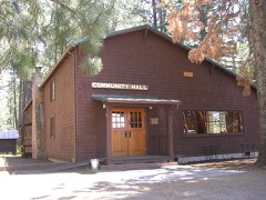 | Camp Sherman Community Hall | building | 2003 | 03000070 |
| Enoch and Mary Cyrus Homestead | site | 2015 | 15000270 | |
| Jefferson County Courthouse | building | 2015 | 15000614 | |
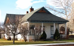 | Max and Ollie Lueddemann House | building | 1996 | 96000620 |
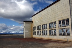 | Madras Army Air Field North Hanger | building | 2015 | 15000331 |
| Julius and Sarah McCoin Homestead | site | 2015 | 15000271 | |
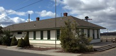 | Oregon Trunk Passenger and Freight Station | building | 1986 | 86000285 |
Every wildfire the federal occurrence database records inside this county: 2,718 of them, burning about 592,126 acres. 922 started naturally and 156 were recorded as arson. Each settlement page carries the fires within five miles of it.
| Reported cause | Fires |
|---|---|
| Natural | 922 |
| Fireworks | 502 |
| Recreation and ceremony | 244 |
| Debris and open burning | 231 |
| Missing data/not specified/undetermined | 204 |
| Arson/incendiarism | 156 |
| Misuse of fire by a minor | 145 |
| Equipment and vehicle use | 130 |
| Smoking | 102 |
| Power generation/transmission/distribution | 38 |
| Other causes | 29 |
| Railroad operations and maintenance | 12 |
| Firearms and explosives use | 3 |
The five largest, by the area the report gives. One of them was set deliberately.
| Date | Cause | Size | Reported by | Name on the report |
|---|---|---|---|---|
| 16 August 2020 | Natural | 204,469 acres | Warm Springs Agency | LIONSHEAD |
| 19 August 2003 | Natural | 79,734 acres | Deschutes National Forest | BOOTH 0848 |
| 20 July 2013 | Arson/incendiarism | 53,000 acres | Warm Springs Agency | SUNNY SIDE |
| 18 August 2010 | Natural | 29,500 acres | Warm Springs Agency | WHITE LIGHTNING |
| 9 July 2002 | Natural | 23,573 acres | Deschutes National Forest | EYERLY 0684 |
| 13 July 2014 | Natural | 22,760 acres | Prineville District | 0319 DONNY BROOK |
| 6 August 2012 | Natural | 12,246 acres | Warm Springs Agency | WATER FALLS#2 |
| 12 July 2007 | Natural | 11,710 acres | Warm Springs Agency | BIDDLE PASS |
Every settlement page carries the fires within five miles of it - see the settlement index below.
The NOAA Storm Events Database holds 87 reports for this county, causing 1 death, no injuries and about $5,630,100 in recorded property damage. Each settlement page carries the reports that name it.
| Kind of event | Reports |
|---|---|
| Hail | 37 |
| Thunderstorm Wind | 27 |
| Wildfire | 8 |
| Heavy Rain | 6 |
| Lightning | 4 |
| Funnel Cloud | 2 |
| Tornado | 1 |
| Dust Devil | 1 |
| Flash Flood | 1 |
The most serious of them, by death, then injury, then recorded damage. The accounts are quoted exactly as the forecast office filed them.
| When | Event | Place named | Harm | What the report says |
|---|---|---|---|---|
| August 2013 | Lightning | Madras | 1 killed | KPTV Fox 12 News reported the story. The article was posted online as well. |
| July 2002 | Wildfire | Warm Spgs | $5,500,000 | The Eyerly Fire, sparked by lightning, consumed 23,573 acres and destroyed several structures, including 18 homes, 13 out buildings, three travel trailers, and two cars. In addition, one home and five buildings were damaged. |
| August 2009 | Thunderstorm Wind | Madras Arpt | $50,000 | Sudden and sustained winds from collapsing supercell broke all three boat docks off the shore of Pelton Park Reservoir. Every tent in the park was flattened by the wind. |
| July 2004 | Lightning | Culver | $40,000 | no account filed |
| May 2001 | Hail | Gateway | $20,000 | no account filed |
| August 2009 | Thunderstorm Wind | Culver | $10,000 | Public estimated 50-60 mph sustained winds. A tree fell on top of a vehicle. |
| August 2019 | Thunderstorm Wind | Warm Spgs | $5,000 | Wind caused damage to fencing in the area. |
| March 2011 | Thunderstorm Wind | Madras Arpt | $1,000 | The Madras Pioneer newspaper reported a sudden wind and rain storm with gusts to 60 mph at the airport. There was a split Juniper tree and a fence blown down on northeast Elm Lane. Power lines were down at the experiment station north of Madras. The plastic was torn up on a greenhouse on South Adams Drive. |
| August 1999 | Thunderstorm Wind | Culver | $1,000 | Tree branches up to 6 inches in diameter blown off by thunderstorm winds. |
| August 1999 | Thunderstorm Wind | Warm Spgs | $1,000 | Strong winds from thunderstorms knocked down branches up to 6 inches in diameter. |
| June 2004 | Tornado (F0) | Madras | $1,000 | no account filed |
| August 2012 | Lightning | Opal City | $500 | Lightning causes a power outage in the Crooked River Ranch subdivision. |
| June 2009 | Thunderstorm Wind | Madras | $500 | Broken limbs and tree damage in Madras. |
| June 2009 | Thunderstorm Wind | Madras | $100 | Between 120 pm and 200 pm...1 to 4 inch diameter trees and branches downed. Rainfall of .68 inch in 1/2 hour. |
| July 2025 | Funnel Cloud | Opal City | - | Chief Meteorologist from KTVZ in Bend, OR shared a viewer video of a funnel cloud briefly touching down near Crooked River Ranch Golf Course. |
| May 2023 | Hail | Madras Arpt | - | A trained spotter 2 miles W of Madras reported hail stones up to 0.88 inches in size at 2006 PDT. |
| May 2023 | Flash Flood | Cove Palisades St Pk | - | Via the Jefferson Counties Sheriff's Office social media post, the SW Jordan road leading to the Billy Chinook Lake was closed due to high water and debris from flash flooding. An estimated up to 1.5 inches of rainfall occurred over a 2 hour period within the immediate area, resulting in water draining into a dry waterfall, with the road closure at the bottom of this waterfall. |
| July 2022 | Thunderstorm Wind | Madras | - | The Madras airport ASOS measured a wind gust of 67mph at 5:55pm. An NWS employee 1 mile southwest of Madras, OR also witnessed thunderstorm outflow winds that blew down fences, produced low visibilities in blowing dust, and also produced a gustnado in nearby farm fields. |
| August 2020 | Thunderstorm Wind | Madras | - | Report by spotter of downed powerlines along highway 26 between Warm Springs and Madras. |
| August 2020 | Thunderstorm Wind | Gateway | - | Trees down and neighbor lost porch. |
| August 2020 | Thunderstorm Wind | Gateway | - | Power poles reported down. |
| May 2020 | Thunderstorm Wind | Warm Spgs | - | Powerlines and trees down. Roof blown off house. |
| May 2020 | Thunderstorm Wind | Culver | - | A concentrated swath of destructive straight line winds affected the Culver and Metolius areas of Jefferson County. Within this swath there were numerous large trees uprooted and snapped, hundreds of yards of irrigation line dislodged and/or mangled, and several snapped power poles. Some of the most significant damage included destruction of a handful of agricultural out buildings and partial or total roof removals of at least two manufactured homes. |
| May 2020 | Thunderstorm Wind | Madras | - | Multiple reports of trees down in Madras. Alfalfa crop destroyed by hail and strong winds. |
| May 2020 | Hail | Madras | - | Also 60-70 mph winds. |
| May 2017 | Hail | Culver Chinook Arpt | - | Estimated 1.75 inch hail occurred at Crooked River Ranch, 9 miles NW of Terrebonne in Jefferson county. |
| May 2017 | Hail | Culver Chinook Arpt | - | Measured 1.00 inch hail occurred northwest of Terrebonne in Jefferson county. |
| May 2017 | Hail | Madras | - | Measured 1.75 inch hail occurred at Madras in Jefferson county. Report from public post on NWS Pendleton Facebook page. |
| May 2017 | Hail | Culver Chinook Arpt | - | Estimated 1.00 inch hail occurred 11 miles NW of Terrebonne in Jefferson county. |
| May 2017 | Hail | Madras | - | Measured 1.50 inch hail occurred 3 miles W of Madras in Jefferson county. |
| September 2013 | Thunderstorm Wind | Culver Chinook Arpt | - | Public reported that chimney had blown off their roof. |
| September 2013 | Thunderstorm Wind | Warm Spgs | - | Public reported 4 two foot diameter trees were uprooted, and irrigation pivots had been overturned. |
| August 2013 | Thunderstorm Wind | Paxton | - | Numerous irrigation wheel lines damaged and quarter sized hail. |
| July 2012 | Heavy Rain | Ashwood | - | Heavy rainfall accompanied by small hail and wind gust to 30 mph. |
| July 2012 | Hail | Black Butte | - | Silver dollar sized hail reported at Sutter Lodge. |
| July 2012 | Heavy Rain | Culver | - | Two spotters reported up to 1.35 inch in 1 hour and small hail to 1/4 inch. |
| July 2012 | Hail | Culver | - | At Lake Billy Chinook, a family member of NWS employee reported quarter sized hail and 6 inches of water running through the campground due to heavy rainfall. |
| August 2011 | Heavy Rain | Warm Spgs | - | Spotter reported 1 inch of rain fell in 15 minutes. |
| June 2009 | Thunderstorm Wind | Madras | - | Trees downed by thunderstorm high winds. |
| August 2009 | Hail | Culver | - | Also, minor flooding was reported due to brief heavy rainfall. |
| August 2008 | Hail | Opal City | - | Large hail reported at Crooked River Ranch. |
| August 2008 | Hail | Culver | - | Hail accompanied by heavy rainfall. |
| June 2007 | Hail | Warm Spgs | - | Rural resident reported hail to around nickel size accompanied by heavy rainfall. |
| July 2006 | Thunderstorm Wind | Culver | - | Trees down. Reported by law enforcement. |
| June 2006 | Thunderstorm Wind | Ashwood | - | Numerous 8 inch diameter tree branches downed. Wind along with dime size hail damaged grass and alfalfa crop. Rainfall of 1.50 inch in 20 minutes caused extensive runoff which damaged fences and farm road. |
| August 2003 | Hail | Culver | - | Hail from a thunderstorm in Jefferson county led to some crop damage in Culver, Metolius, as well as the Agency Plains. Crops that were damaged from the storm include potatoes, wheat, carrots, and onions. |
| August 2003 | Wildfire | Camp Sherman | - | The Booth and Bear Butte Fires burned a total of 91,000 acres. The cause of the fire was determined to be prior lightning strikes which created some hot spots that later flared up into a wildfire. Dry conditions and occasionally higher winds contributed to the growth of the fire. Hundreds of residents were evacuated from Camp Sherman. Eight camp cabins were destroyed at the Round Lake Christian Camp. In addition, three other outbuildings were also destroyed. More than 2,000 personal were involved in the Booth and Bear Butte Fires. The cost of fighting the fire totaled more than 32 million dollars. The property damage from this event is unknown. |
| September 2003 | Wildfire | Camp Sherman | - | The Booth and Bear Butte Fires began on August 19th and burned a total of 91,000 acres. The cause of the fire was determined to be prior lightning strikes which created hot spots that later flared up into a wildfire. Dry conditions and occasionally higher winds contributed to the growth of the fire. Hundreds of residents were evacuated from Camp Sherman. Eight camp cabins were destroyed at the Round Lake Christian Camp. In addition, three other outbuildings were also destroyed. More than 2,000 personnel were involved in the Booth and Bear Butte Fires. The cost of fighting the fire totaled more than 32 million dollars. The property damage from this event is unknown. |
| June 2002 | Wildfire | Culver | - | Lightning on June 13th started the Geneva Fire which burned 194 acres. |
| July 2001 | Hail | Culver | - | A spotter reported penny-sized hail on the west side of Lake Chinook. |
| July 2001 | Lightning | Camp Sherman | - | Lightning started a 6 day fire that burned 1800 acres northwest of Camp Sherman. This fire, named the Bald Peter Fire, threatened trout habitat in the Metolius River and cost 1.2 million dollars to control. |
| May 1998 | Heavy Rain | Ashwood | - | 1.50 inches of rain fell in 24 hours. |
| July 1998 | Wildfire | Warm Spgs | - | A brush fire burned about 100 acres on the Warm Springs Indian Reservation. Highway 26 was closed for about an hour to give fire fighters quick access to the area. High wind complicated fire fighting efforts. The source of the fire appeared to be a dump site. |
| August 1998 | Wildfire | Madras | - | A wild fire burned 500 acres of rangeland about 5 miles west of Madras and prompted the evacuation of about 150 homes. No homes burned, however, one outbuilding and some farm equipment was destroyed by the fire. About 300 firefighters, 24 fire engines, helicopters and three air tankers were called in to help fight the fire. Two firefighters were injured, one suffered heat exhaustion and the other had a back injury. |
| August 1998 | Wildfire | Countywide | - | Lightning caused a 160 acre forest fire in extreme southwestern Jefferson County. Campers in the southern part of the Mount Jefferson Wilderness area were evacuated. Trails and Forest Service roads were closed and Highway 20 was restricted from four lanes to two so that fire fighters could access the fire. Three air tankers and two helicopters were used to help control the fire. The fire was contained on August 22. A second fire burned 300 acres of wheat stubble and grassland north of Madras. That fire was contained on August 20. |
| July 1997 | Heavy Rain | Madras | - | Heavy rain in Madras caused flooding of some streets and businesses. |
| July 1997 | Heavy Rain | Opal City | - | Heavy rain and lightning strikes knocked out power from Opal City to Madras. Some phone service was also down for a while. |
| July 2014 | Hail | Culver Chinook Arpt | - | no account filed |
| August 2013 | Hail | Madras | - | no account filed |
| August 2013 | Hail | Madras | - | no account filed |
The Survey's mineral resources record lists 105 workings inside this county. 28 still produce and 77 are closed or unrecorded. Each settlement page carries the workings within five miles of it.
| Commodity | Workings |
|---|---|
| Mercury | 32 |
| Stone | 27 |
| Stone, Crushed/Broken | 19 |
| Sand and Gravel, Construction | 12 |
| Gold | 5 |
| Silver, Antimony | 2 |
| Pumice | 2 |
| Mercury, Antimony, Copper, Gold, Silver | 1 |
| Silver, Gold | 1 |
| Silver, Lead, Copper, Zinc, Gold | 1 |
| Antimony, Arsenic | 1 |
| Mercury, Arsenic, Antimony, Sulfur, Gold | 1 |
| Stone, Dimension | 1 |
| Arsenic, Antimony | 1 |
The least common of them first, because a county's hundredth gravel pit says nothing its first ten did not.
| Where | Site | Commodity | Status | Recorded |
|---|---|---|---|---|
| Axehandle Mine | Mercury, Arsenic, Antimony, Sulfur, Gold | Past Producer | 1935, 1936 | |
| Axehandle Mine | Mercury, Gold, Arsenic, Antimony | Producer | 1936, 1937 | |
| Horse Heaven Mine | Mercury, Arsenic, Antimony | Past Producer | 1933, 1934 | |
| Oregon King Mine | Silver, Lead, Copper, Zinc, Gold, Antimony, Arsenic | Past Producer | 1898, 1899 | |
| Oregon King Mine | Zinc, Lead, Gold, Copper, Silver | Plant | 1898 | |
| Priday Polka Dot Beds | Semiprecious Gemstone | Producer | ||
| Red Jacket | Mercury, Antimony, Copper, Gold, Silver | Occurrence | Cinnabar, Limonite, Marcasite, Pyrite, Stibnite | |
| Red Jacket Mine | Mercury, Silver, Gold, Copper, Antimony | Prospect | ||
| Roy Mining Property | Silver, Gold | Occurrence | 1900 | |
| Roy Mining Property | Silver, Gold | Occurrence | ||
| Willowdale Rose | Stone, Dimension | Past Producer | ||
| Willowdale Rose | Volcanic Materials | Producer | ||
| Queen of Oregon | Gold, Silver, Antimony | Occurrence | Stibnite | |
| Queen of Oregon | Gold, Silver, Antimony | Prospect | ||
| Round Butte Cinder Pit | Pumice | Producer | ||
| Round Butte Cinder Pit | Pumice | Producer | ||
| Gold Mine | Gold | Past Producer | ||
| Unnamed Prospect | Gold | Unknown | ||
| Borrow Pit | Sand and Gravel, Construction | Past Producer | ||
| Gravel Pit | Sand and Gravel, Construction | Past Producer | ||
| Gravel Pit | Sand and Gravel, Construction | Past Producer | ||
| Gravel Pit | Sand and Gravel, Construction | Past Producer | ||
| Gravel Pit | Sand and Gravel, Construction | Past Producer | ||
| Steelhead Falls Pit | Sand and Gravel, Construction | Past Producer | ||
| Steelhead Falls Pit | Sand and Gravel, Construction | Producer | ||
| Unnamed Pit | Sand and Gravel, Construction | Past Producer | ||
| Unnamed Pit | Sand and Gravel, Construction | Producer | ||
| Unnamed Pit | Sand and Gravel, Construction | Producer | ||
| Willow Creek Quarry | Sand and Gravel, Construction | Past Producer | ||
| Willow Creek Quarry | Sand and Gravel, Construction | Producer | ||
| Culver Quarry | Stone, Crushed/Broken | Producer | ||
| Gateway Quarry | Stone, Crushed/Broken | Producer | ||
| Grody Quarry | Stone, Crushed/Broken | Past Producer | ||
| Jefferson County Pit | Stone, Crushed/Broken | Producer | ||
| Madras/Prineville Hwy Jct | Stone, Crushed/Broken | Producer | ||
| Metolius Quarry | Stone, Crushed/Broken | Producer | ||
| Opal Spring | Stone, Crushed/Broken | Producer | ||
| Pelton Pit | Stone, Crushed/Broken | Producer | ||
| Qualle Quarry | Stone, Crushed/Broken | Producer | ||
| Round Butte Cinder Pit | Stone, Crushed/Broken | Past Producer | ||
| Round Butte Cinder Pit | Stone, Crushed/Broken | Past Producer | ||
| Schmoker Quarry | Stone, Crushed/Broken | Producer | ||
| Swanson Quarry | Stone, Crushed/Broken | Producer | ||
| Unnamed Pit | Stone, Crushed/Broken | Producer | ||
| Unnamed Pit | Stone, Crushed/Broken | Producer | ||
| Unnamed Pit | Stone, Crushed/Broken | Producer | ||
| Unnamed Pit | Stone, Crushed/Broken | Producer | ||
| Unnamed Pit | Stone, Crushed/Broken | Producer | ||
| Zimpki Pit | Stone, Crushed/Broken | Past Producer | ||
| Basalt Quarry | Stone | Past Producer | ||
| Basalt Quarry | Stone | Past Producer | ||
| Culver Quarry | Stone | Past Producer | ||
| Gateway Quarry | Stone | Past Producer | ||
| Grenada | Stone | Past Producer | ||
| Grenada | Stone | Producer | ||
| Grody Quarry | Stone | Past Producer | ||
| Jefferson County | Stone | Past Producer | ||
| Madias Quarry | Stone | Past Producer | ||
| Madras Pit | Stone | Producer | ||
| Madras/Prineville Hwy Jctse | Stone | Past Producer | ||
| Metolius Quarry | Stone | Past Producer | ||
| Opal Spring | Stone | Past Producer | ||
| Pelton | Stone | Past Producer | ||
| Qualle Quarry | Stone | Past Producer | ||
| Quarry | Stone | Past Producer | ||
| Quarry | Stone | Past Producer | ||
| Quarry | Stone | Past Producer | ||
| Quarry | Stone | Past Producer | ||
| Quarry | Stone | Past Producer | ||
| Schmoker | Stone | Past Producer | ||
| Stevenson Quarry | Stone | Past Producer | ||
| Stevenson Quarry | Stone | Producer | ||
| Swanson Quarry | Stone | Past Producer | ||
| Warm Springs Quarry | Stone | Past Producer | ||
| Warm Springs Quarry | Stone | Past Producer | ||
| Zimpki Quarry | Stone | Past Producer | ||
| Big Muddy Cinnabar | Mercury | Occurrence | 1935 | |
| Big Muddy Cinnabar | Mercury | Past Producer | ||
| Cherry Creek | Mercury | Occurrence | 1943 | |
| Cherry Creek | Mercury | Prospect | ||
| Custer Young | Mercury | Occurrence | 1937 | |
| Custer Young | Mercury | Prospect | ||
| Friend | Mercury | Occurrence | ||
| Good Chance Prospect | Mercury | Occurrence | 1937 | |
| Good Chance Prospect | Mercury | Prospect | ||
| Good Earth Prospect | Mercury | Occurrence | 1954 | |
| Good Earth Prospect | Mercury | Prospect | ||
| Gray Butte | Mercury | Occurrence | 1942 | |
| Gray Butte | Mercury | Prospect | ||
| Horse Creek | Mercury | Occurrence | Cinnabar, Marcasite | |
| Horse Creek | Mercury | Prospect | ||
| Humboldt | Mercury | Past Producer | 1935 | |
| Humbolt Mine | Mercury | Past Producer | ||
| Mercury Prospect | Mercury | Occurrence | ||
| Opal Creek | Mercury | Occurrence | 1940 | |
| Opal Creek Prospect | Mercury | Unknown | ||
| Opal Mountain | Mercury | Occurrence | 1940 | |
| Opal Mountain Prospect | Mercury | Unknown | ||
| Redskin | Mercury | Occurrence | 1954 | |
| Redskin | Mercury | Prospect | ||
| Roark | Mercury | Occurrence | Cinnabar | |
| Roark Prospect | Mercury | Unknown | ||
| Roark and Lowry | Mercury | Occurrence | 1941 | |
| Roark and Lowry | Mercury | Prospect | ||
| Unnamed Prospect | Mercury | Unknown |
Named settlements recorded in the Geographic Names Information System, each with the topographic sheets covering it. Villages, hamlets and abandoned places alike. Each is shown with the nearest named watercourse or landform and the survey quadrangle it falls on.
Ashwood census division · 97711 · Near Slaughterhouse Gulch · Ashwood quadrangle
7 sheets, 1955 to 1981
Ashwood census division · 97711 · On Axehandle Butte · Donnybrook quadrangle
8 sheets, 1955 to 1987
No longer a settlement
Grandview census division · 97730 · On North Fork Lake Creek · Black Butte quadrangle
16 sheets, 1929 to 1988
Culver census division · 97760 · Near Osborne Canyon · Opal City quadrangle
17 sheets, 1926 to 1992
Ashwood census division · 97711 · Near Axehandle Butte · Donnybrook quadrangle
8 sheets, 1955 to 1987
No longer a settlement
Ashwood census division · Near Hinkle Butte · Horse Heaven Creek quadrangle
8 sheets, 1955 to 1981
Ashwood census division · 97711 · Near Coyote Mountain · Horse Heaven Creek quadrangle
8 sheets, 1955 to 1981
Ashwood census division · 97741 · Gray Butte quadrangle
17 sheets, 1926 to 1992
No longer a settlement
Culver census division · 97734 · Near Osborne Canyon · Opal City quadrangle
17 sheets, 1926 to 1992
Warm Springs census division · 97761 · On Tenino Creek · Warm Springs quadrangle
11 sheets, 1928 to 1983
Ashwood census division · 97741 · On Pony Creek · Willowdale quadrangle
8 sheets, 1955 to 1987
The vanished settlements of Jefferson County: the places named above that are no longer on the map.