 Block
From the record
5 National Register listings published here.
Sources: the National Register database, National Park Service
42 topographic sheets cover 17 settlements here, and 5 properties are on the National Register of Historic Places.
5 National Register listings published here.
Sources: the National Register database, National Park Service
Every property in this county listed on the National Register of Historic Places, with the year it was listed and the federal nomination document.
| Photograph | Property | Type | Listed | Reference |
|---|---|---|---|---|
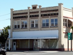 | Gilliam and Bisbee Building | building | 1990 | 90000840 |
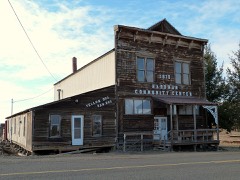 | Hardman I.O.O.F. Lodge Hall | building | 2012 | 12000484 |
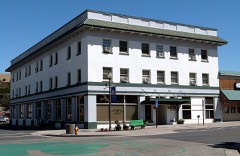 | Heppner Hotel | building | 1982 | 82001511 |
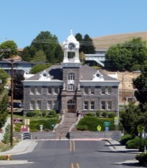 | Morrow County Courthouse | building | 1985 | 85000366 |
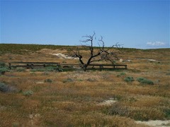 | Oregon Trail, Wells Springs Segment | site | 1978 | 78002305 |
Every wildfire the federal occurrence database records inside this county: 673 of them, burning about 156,396 acres. 394 started naturally and 22 were recorded as arson. Each settlement page carries the fires within five miles of it.
| Reported cause | Fires |
|---|---|
| Natural | 394 |
| Recreation and ceremony | 147 |
| Missing data/not specified/undetermined | 40 |
| Debris and open burning | 33 |
| Arson/incendiarism | 22 |
| Equipment and vehicle use | 18 |
| Smoking | 9 |
| Power generation/transmission/distribution | 3 |
| Other causes | 3 |
| Railroad operations and maintenance | 3 |
| Misuse of fire by a minor | 1 |
The five largest, by the area the report gives. None of them was recorded as arson.
| Date | Cause | Size | Reported by | Name on the report |
|---|---|---|---|---|
| 29 June 2008 | Natural | 78,000 acres | Umatilla National Wildlife Refuge | COAL PLANT |
| 13 July 2007 | Natural | 53,448 acres | Umatilla National Forest | RED HILL |
| 2 August 1994 | Natural | 7,000 acres | Prineville District | HORN BUTTE |
| 19 June 2003 | Missing data/not specified/undetermined | 4,000 acres | Umatilla National Wildlife Refuge | WEST BOUNDRY |
| 23 May 2016 | Equipment and vehicle use | 3,000 acres | Umatilla Agency | 1605230053 |
| 6 August 2019 | Natural | 1,350 acres | Umatilla National Forest | LITTLE BEAR |
| 6 August 2016 | Debris and open burning | 1,141 acres | McNary National Wildlife Refuge | BOARDMAN |
| 18 July 2000 | Missing data/not specified/undetermined | 1,047 acres | Umatilla National Wildlife Refuge | OLD730HWY |
Every settlement page carries the fires within five miles of it - see the settlement index below.
The NOAA Storm Events Database holds 65 reports for this county, causing no deaths, 1 injury and about $1,061,500 in recorded property damage. Each settlement page carries the reports that name it.
| Kind of event | Reports |
|---|---|
| Hail | 31 |
| Thunderstorm Wind | 16 |
| Flash Flood | 6 |
| Heavy Rain | 4 |
| Lightning | 2 |
| Tornado | 2 |
| Flood | 2 |
| Wildfire | 1 |
| Funnel Cloud | 1 |
The most serious of them, by death, then injury, then recorded damage. The accounts are quoted exactly as the forecast office filed them.
| When | Event | Place named | Harm | What the report says |
|---|---|---|---|---|
| August 2000 | Lightning | Boardman | 1 hurt, $20,000 | no account filed |
| May 2006 | Thunderstorm Wind | Boardman | $500,000 | no account filed |
| June 2008 | Thunderstorm Wind | Munley | $250,000 | Morrow County Emergency Management reports trees down on houses with power poles and lines down in the south side of Irrigon. Wind damage to numerous houses and buildings in the Irrigon area. At least 22 power poles down from Paterson Ferry Road to Irrigon. |
| August 2000 | Lightning | Heppner | $100,000 | no account filed |
| May 2011 | Flash Flood | Heppner | $94,000 | One to two inches of rainfall within 1 hour caused flash flooding in the Heppner and Lexington areas. Roads were inundated. A home, two basements, and a garage were flooded. Sandbags were used to protect homes and businesses. |
| June 2011 | Flash Flood | Heppner | $70,000 | Flash flooding on Hinton and Willow Creeks damaged roads, bridges, and the Morrow County Fairgrounds. The Heppner elementary school was evacuated as a precaution. |
| May 2006 | Tornado (F1) | Boardman | $20,000 | Swirling ground debris beneath funnel cloud. Tractor trailer rig blown off Interstate 84. |
| October 2018 | Flood | Heppner | $3,000 | Two feet of water inside a residence due to heavy rain forced four adults and a child to leave their house on the 54200 Block of Highway 74 in Heppner. |
| April 2019 | Flood | Heppner | $2,000 | Flooding along Hinton Creek took place on April 9th and 10th. The fairgrounds in Heppner were flooded as well as fields along the creek above Heppner. |
| April 2005 | Flash Flood | Ione | $2,000 | no account filed |
| April 2011 | Tornado (EF0) | Lexington | $500 | EF0 tornado, which was spotted by a resident, caused damage to a pump house on the farm south southwest of Lexington. Insulation was seen twisting up in the air and 2x4s from the pump house landed 100 yards to the southeast. Pea sized hail was seen prior to the damage and thunder was heard 10 minutes prior to the damage. Trees, grass, and weeds were seen blowing in various directions. |
| August 2023 | Flash Flood | Ione | - | The Morrow County Emergency Manager posted pictures via social media post flash flooding through the town. The pictures showed water overflowing drainage ditches and flowing over the roadway, muddy debris leftover across sidewalks and the road within town, and water still flowing into the area creek from the hills surrounding the town. Other photo's from the city of Ione show water and debris that had flowed into local businesses as well. |
| August 2020 | Thunderstorm Wind | Ione | - | Tree down across route 74 at Ella Road. |
| May 2020 | Thunderstorm Wind | Boardman | - | Tree down in Boardman. |
| April 2013 | Thunderstorm Wind | Heppner | - | Pear tree had several limbs broken off. |
| September 2013 | Thunderstorm Wind | Boardman | - | Estimated wind gusts 80 mph. |
| September 2013 | Thunderstorm Wind | Boardman | - | Public reported several power poles downed. |
| September 2013 | Thunderstorm Wind | Munley | - | Public reported 6 to 12 inch diameter tree down and power outage. |
| September 2013 | Thunderstorm Wind | Munley | - | Half of a barn roof blown off reported on social media. |
| April 2012 | Heavy Rain | Heppner | - | Three quarters of an inch of rainfall fell in a 35 minute period. |
| April 2012 | Flash Flood | Heppner | - | Heavy rainfall caused flash flooding in several areas of Heppner, including residences, the elementary school, sewage treatment plant, city shop, a bank, and the newspaper office. Roadways were also flooded and debris cleanup had to ensue in 10 spots. |
| April 2012 | Heavy Rain | Heppner | - | Rainfall of 1.23 inches was reported in a 1 hour period. |
| July 2012 | Hail | Lena | - | Hail accompanied by minor creek flash flooding. |
| July 2012 | Hail | Heppner | - | Hail dented vehicles, broke windshields and caused some roof damage. |
| July 2012 | Heavy Rain | Heppner | - | Shobe Canyon mesonet station reported 1.1 inches of rainfall in 1 hour. |
| June 2009 | Hail | Hardman | - | Accompanied by wind gusts 40-45 mph and 1/2 inch of rainfall in 20 minutes. |
| August 2008 | Hail | Ione | - | Large hail accompanied by wind gust to 53 mph. |
| May 2006 | Thunderstorm Wind | Irrigon | - | 10,000 poplar trees blown down at Potlatch Tree Farm. Winds estimated 70 to 80 mph. |
| August 2006 | Hail | Hardman | - | Penny size hail covering highway 207. |
| July 2001 | Thunderstorm Wind | Irrigon | - | Several wind sensors located adjacent to the Umatilla Army Depot received severe wind gusts. 3 sites measured gusts of 70, 65 and 59 mph respectively. |
| June 1999 | Hail | Ione | - | A spotter reported nickle-sized hail and 0.31 inches of rain in just 10 minutes one mile north of Ione. |
| April 1998 | Heavy Rain | Heppner | - | Three tenths to one half inch of rain fell in 20 minutes from Heppner to Ione with wind gusts to 40 mph. |
| July 1998 | Wildfire | Boardman | - | Lightning caused a brush fire on the Naval Bombing range south of Boradman that burned more than 30,000 acres. Strong shifting wind, difficult terrain, and heavy brush hampered fire fighting efforts. One hundred fifty Naval and civilian fire fighters fought the fire. |
| May 1997 | Hail | Ione | - | A farmer reported severe damage to wheat crop. Hail dented three vehicles. |
| May 2015 | Hail | Lexington | - | no account filed |
| September 2013 | Hail | Ione | - | no account filed |
| September 2013 | Hail | Lena | - | no account filed |
| September 2013 | Hail | Lena | - | no account filed |
| July 2012 | Hail | Lena | - | no account filed |
| July 2012 | Hail | Lexington | - | no account filed |
| May 2011 | Hail | Lena | - | no account filed |
| June 2010 | Funnel Cloud | Boardman | - | no account filed |
| August 2007 | Hail | Ione | - | no account filed |
| March 2006 | Flash Flood | Boardman | - | no account filed |
| May 2006 | Hail | Boardman | - | no account filed |
| May 2006 | Thunderstorm Wind | Irrigon | - | no account filed |
| May 2006 | Thunderstorm Wind | Irrigon | - | no account filed |
| May 2006 | Thunderstorm Wind | Irrigon | - | no account filed |
| May 2006 | Thunderstorm Wind | Boardman | - | no account filed |
| July 2006 | Hail | Heppner | - | no account filed |
| July 2006 | Hail | Heppner | - | no account filed |
| July 2006 | Hail | Heppner | - | no account filed |
| June 2006 | Hail | Heppner | - | no account filed |
| June 2004 | Hail | Hardman | - | no account filed |
| August 2004 | Hail | Heppner | - | no account filed |
| August 2003 | Hail | Lexington | - | no account filed |
| July 2002 | Hail | Boardman | - | no account filed |
| August 2000 | Hail | Hardman | - | no account filed |
| July 1995 | Hail | Ione | - | no account filed |
| July 1995 | Hail | Ione | - | no account filed |
The Survey's mineral resources record lists 100 workings inside this county. 48 still produce and 52 are closed or unrecorded. Each settlement page carries the workings within five miles of it.
| Commodity | Workings |
|---|---|
| Sand and Gravel, Construction | 33 |
| Stone | 32 |
| Stone, Crushed/Broken | 29 |
| Tungsten | 2 |
| Gemstone | 1 |
| Silica | 1 |
| Semiprecious Gemstone | 1 |
| Geothermal | 1 |
| Gold | 1 |
The least common of them first, because a county's hundredth gravel pit says nothing its first ten did not.
| Where | Site | Commodity | Status | Recorded |
|---|---|---|---|---|
| Columbia River Sand Dunes | Sand and Gravel, Construction, Silica | Occurrence | ||
| Gemstones Mine | Gemstone | Past Producer | ||
| Madison Butte | Gold | Prospect | ||
| Unnamed Site | Semiprecious Gemstone | Producer | ||
| Wells Spring | Geothermal | Producer | ||
| Big Dip | Tungsten | Occurrence | Unknown | |
| Big Dip | Tungsten | Prospect | ||
| Butter Creek Quarry | Stone, Crushed/Broken | Producer | ||
| Chick Quarry | Stone, Crushed/Broken | Producer | ||
| Clark Canyon Quarry | Stone, Crushed/Broken | Producer | ||
| Cutsforth Quarry | Stone, Crushed/Broken | Producer | ||
| Halverson Site | Stone, Crushed/Broken | Producer | ||
| Mp 39 Heppner/Willow Creek Pit | Stone, Crushed/Broken | Producer | ||
| Mp 59.6 Wasco/Hepper Hwy | Stone, Crushed/Broken | Producer | ||
| Mp 60.5 Wasco/Hepper Hwy | Stone, Crushed/Broken | Producer | ||
| Mp 67.4 Heppner Hwy | Stone, Crushed/Broken | Producer | ||
| Mp 75.7 Wasco/Hepper Hwy | Stone, Crushed/Broken | Producer | ||
| Rhea Creek Quarry | Stone, Crushed/Broken | Producer | ||
| Riprap Quarry | Stone, Crushed/Broken | Producer | ||
| Rivercrest Pit | Stone, Crushed/Broken | Producer | ||
| Rugg Quarry | Stone, Crushed/Broken | Producer | ||
| Ruhl Pit | Stone, Crushed/Broken | Producer | ||
| Skinners Fork Quarry | Stone, Crushed/Broken | Producer | ||
| Three-Mile Pit | Stone, Crushed/Broken | Producer | ||
| Unnamd Pit | Stone, Crushed/Broken | Producer | ||
| Unnamed Pit | Stone, Crushed/Broken | Producer | ||
| Unnamed Pit | Stone, Crushed/Broken | Producer | ||
| Unnamed Pit | Stone, Crushed/Broken | Producer | ||
| Unnamed Pit | Stone, Crushed/Broken | Producer | ||
| Unnamed Pit | Stone, Crushed/Broken | Producer | ||
| Unnamed Pit | Stone, Crushed/Broken | Producer | ||
| Unnamed Pit | Stone, Crushed/Broken | Producer | ||
| Unnamed Pit | Stone, Crushed/Broken | Producer | ||
| Unnamed Pit | Stone, Crushed/Broken | Producer | ||
| Unnamed Pit | Stone, Crushed/Broken | Producer | ||
| Unnamed Pit | Stone, Crushed/Broken | Producer | ||
| Basalt Quarry | Stone | Past Producer | ||
| Basalt Quarry | Stone | Past Producer | ||
| Basalt Quarry | Stone | Past Producer | ||
| Butter Creek Quary | Stone | Past Producer | ||
| Cecil Rock Production | Stone | Past Producer | ||
| Cecil Rock Production | Stone | Producer | ||
| Chick Quarry | Stone | Past Producer | ||
| Clark Canyon Quarry | Stone | Past Producer | ||
| Cutsfordh Quarry | Stone | Past Producer | ||
| Halverson Site | Stone | Past Producer | ||
| Mp 39 Heppner/Willow Creek Pit | Stone | Past Producer | ||
| Mp 59.6 Wasco/Hepper Hwy | Stone | Past Producer | ||
| Mp 60.5 Wasco/Hepper Hwy | Stone | Past Producer | ||
| Mp 67.4 Heppner Hwy | Stone | Past Producer | ||
| Mp 75.7 Wasco/Hepper Hwy | Stone | Past Producer | ||
| Quarry | Stone | Past Producer | ||
| Quarry | Stone | Past Producer | ||
| Quarry | Stone | Past Producer | ||
| Quarry | Stone | Past Producer | ||
| Quarry | Stone | Past Producer | ||
| Quarry | Stone | Past Producer | ||
| Quarry | Stone | Past Producer | ||
| Quarry | Stone | Past Producer | ||
| Quarry | Stone | Past Producer | ||
| Rhea Creek Quarry | Stone | Past Producer | ||
| Riprap Quarry | Stone | Past Producer | ||
| Rivercrest | Stone | Past Producer | ||
| Rugg Quarry | Stone | Past Producer | ||
| Ruhl | Stone | Past Producer | ||
| Skinners Fork Quarry | Stone | Past Producer | ||
| Three- Mile Pit | Stone | Past Producer | ||
| Zinter Quarry | Stone | Past Producer | ||
| Boardman Pit | Sand and Gravel, Construction | Past Producer | ||
| Boardman Pit | Sand and Gravel, Construction | Past Producer | ||
| Boardman Pit | Sand and Gravel, Construction | Producer | ||
| Boardman Pit | Sand and Gravel, Construction | Producer | ||
| Borrow Pit | Sand and Gravel, Construction | Past Producer | ||
| Columbia River Sand Dunes | Sand and Gravel, Construction | Occurrence | ||
| Food Processing Park | Sand and Gravel, Construction | Past Producer | ||
| Food Processing Park | Sand and Gravel, Construction | Producer | ||
| Gravel Pit | Sand and Gravel, Construction | Past Producer | ||
| Gravel Pit | Sand and Gravel, Construction | Past Producer | ||
| Gravel Pit | Sand and Gravel, Construction | Past Producer | ||
| Gravel Pit | Sand and Gravel, Construction | Past Producer | ||
| Gravel Pit | Sand and Gravel, Construction | Past Producer | ||
| Gravel Pit | Sand and Gravel, Construction | Past Producer | ||
| Gravel Pit | Sand and Gravel, Construction | Past Producer | ||
| Navy Sand Pit | Sand and Gravel, Construction | Past Producer | ||
| Navy Sand Pit | Sand and Gravel, Construction | Producer | ||
| Six-Mile Canyon Pit | Sand and Gravel, Construction | Past Producer | ||
| Six-Mile Canyon Pit | Sand and Gravel, Construction | Past Producer | ||
| Six-Mile Canyon Pit | Sand and Gravel, Construction | Producer | ||
| Six-Mile Canyon Pit | Sand and Gravel, Construction | Producer | ||
| South Bombing Range Pit | Sand and Gravel, Construction | Past Producer | ||
| South Bombing Range Pit | Sand and Gravel, Construction | Producer | ||
| Unnamed Pit | Sand and Gravel, Construction | Producer | ||
| Unnamed Pit | Sand and Gravel, Construction | Producer | ||
| Unnamed Pit | Sand and Gravel, Construction | Producer | ||
| Unnamed Pit | Sand and Gravel, Construction | Producer | ||
| Unnamed Pit | Sand and Gravel, Construction | Producer | ||
| Unnamed Pit | Sand and Gravel, Construction | Producer | ||
| Unnamed Pit | Sand and Gravel, Construction | Producer | ||
| Unnamed Pit | Sand and Gravel, Construction | Producer | ||
| Zinter Quarry | Sand and Gravel, Construction | Producer |
Named settlements recorded in the Geographic Names Information System, each with the topographic sheets covering it. Villages, hamlets and abandoned places alike. Each is shown with the nearest named watercourse or landform and the survey quadrangle it falls on.
Ione-Lexington census division · 97843 · On Brandy Creek · Cecil quadrangle
13 sheets, 1906 to 1984
Heppner census division · 97836 · Near Carpenter Butte · Butter Creek Junction quadrangle
11 sheets, 1908 to 1984
No longer a settlement
Heppner census division · 97836 · Near Merrill Canyon · Hardman quadrangle
7 sheets, 1953 to 1981
No longer a settlement
Heppner census division · 97836 · On Shobe Creek · Heppner quadrangle
8 sheets, 1953 to 1981
Ione-Lexington census division · 97843 · On Lorraine Creek · Ione North quadrangle
13 sheets, 1906 to 1984
Boardman census division · 97844 · Near Island Number 17 (historical) · Irrigon quadrangle
14 sheets, 1908 to 1993
Ione-Lexington census division · 97839 · Near Blackhorse Canyon · Lexington quadrangle
7 sheets, 1953 to 1981
Ione-Lexington census division · 97843 · In Morgan Canyon · Cecil quadrangle
13 sheets, 1906 to 1984
Heppner census division · 97826 · On Little Butter Creek · Butter Creek Junction quadrangle
11 sheets, 1908 to 1984
Ione-Lexington census division · 97843 · Near Huston Canyon · Eightmile quadrangle
7 sheets, 1953 to 1981
The vanished settlements of Morrow County: the places named above that are no longer on the map.