 Block
From the record
4 National Register listings published here.
Sources: the National Register database, National Park Service
42 topographic sheets cover 19 settlements here, and 4 properties are on the National Register of Historic Places.
4 National Register listings published here.
Sources: the National Register database, National Park Service
Every property in this county listed on the National Register of Historic Places, with the year it was listed and the federal nomination document.
| Photograph | Property | Type | Listed | Reference |
|---|---|---|---|---|
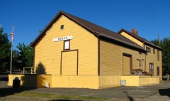 | Columbia Southern Railroad Passenger Station and Freight Warehouse | building | 1991 | 91000059 |
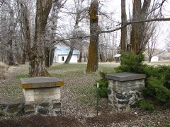 | DeMoss Springs Park | site | 2007 | 07000366 |
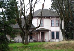 | John and Helen Moore House | building | 1994 | 94000806 |
| Sherman County Courthouse | building | 1998 | 98001122 |
Every wildfire the federal occurrence database records inside this county: 74 of them, burning about 137,993 acres. 32 started naturally and 1 was recorded as arson. Each settlement page carries the fires within five miles of it.
| Reported cause | Fires |
|---|---|
| Natural | 32 |
| Missing data/not specified/undetermined | 25 |
| Recreation and ceremony | 6 |
| Equipment and vehicle use | 5 |
| Railroad operations and maintenance | 2 |
| Other causes | 1 |
| Arson/incendiarism | 1 |
| Power generation/transmission/distribution | 1 |
| Debris and open burning | 1 |
The five largest, by the area the report gives. None of them was recorded as arson.
| Date | Cause | Size | Reported by | Name on the report |
|---|---|---|---|---|
| 1 July 2008 | Natural | 20,115 acres | Prineville District | 0250 JACK KNIFE |
| 3 August 2007 | Missing data/not specified/undetermined | 15,591 acres | Prineville District | 0621 |
| 22 June 2018 | Natural | 15,589 acres | Prineville District | JACK KNIFE |
| 13 July 2014 | Natural | 13,161 acres | Prineville District | 0290 JACK KNIFE |
| 3 July 2008 | Natural | 9,787 acres | Prineville District | 0284 I284 |
| 24 July 1994 | Natural | 7,000 acres | Prineville District | NARROWS |
| 8 June 2016 | Natural | 6,300 acres | Prineville District | 0162 CURRIE CANYON |
| 3 October 2018 | Missing data/not specified/undetermined | 5,877 acres | Prineville District | 1241 |
Every settlement page carries the fires within five miles of it - see the settlement index below.
The NOAA Storm Events Database holds 19 reports for this county, causing no deaths, 1 injury and about $50,000 in recorded property damage. Each settlement page carries the reports that name it.
| Kind of event | Reports |
|---|---|
| Thunderstorm Wind | 9 |
| Hail | 8 |
| Flash Flood | 1 |
| Funnel Cloud | 1 |
The most serious of them, by death, then injury, then recorded damage. The accounts are quoted exactly as the forecast office filed them.
| When | Event | Place named | Harm | What the report says |
|---|---|---|---|---|
| May 2006 | Hail | Grass Vly | 1 hurt | A motorcycle rider was bruised by the wind blown hail. |
| May 2006 | Thunderstorm Wind | Grass Vly | $50,000 | A tractor trailer rig was blown over. A tree fell through a house. |
| August 2024 | Thunderstorm Wind | Rufus | - | Mesonet stations along I-84 recorded wind gusts as high as 79 mph in Sherman County. |
| August 2024 | Hail | Kent | - | Facebook report of hail slightly bigger than a quarter at Grass Valley. |
| May 2020 | Thunderstorm Wind | Grass Vly | - | Patjens RAWS measured gust. |
| August 2019 | Thunderstorm Wind | Grass Vly | - | Measured by RAWS station. |
| March 2011 | Thunderstorm Wind | Kent Decker Arpt | - | Wind gust to 59 mph at North Pole Ridge RAWS. |
| March 2011 | Thunderstorm Wind | Grass Vly | - | Wind gust to 63 mph at spotter's residence. |
| May 2010 | Hail | Klondike | - | Hail ranged from dime to nickel size and thinly coated the ground along Highway 206. |
| May 2010 | Hail | Kent | - | Nickel sized hail reported. |
| May 2010 | Hail | Kent | - | Hail up to 1 inch diameter completely covered the ground. |
| June 2009 | Funnel Cloud | Grass Vly | - | Funnel cloud was 1/3 of the distance from cloud to ground and lasted for 45 seconds. |
| August 2003 | Flash Flood | Rufus | - | Heavy rain led to some flash flooding in the city of Rufus. City hall, emergency services, three residential basements experienced some flooding. In addition, some road damage was also reported. |
| May 2020 | Thunderstorm Wind | Rufus | - | no account filed |
| May 2020 | Thunderstorm Wind | Grass Vly | - | no account filed |
| September 2013 | Hail | Moro | - | no account filed |
| August 2013 | Hail | Kent | - | no account filed |
| May 2006 | Thunderstorm Wind | Grass Vly | - | no account filed |
| August 1963 | Hail | not stated | - | no account filed |
The Survey's mineral resources record lists 43 workings inside this county. 20 still produce and 23 are closed or unrecorded. Each settlement page carries the workings within five miles of it.
| Commodity | Workings |
|---|---|
| Stone, Crushed/Broken | 14 |
| Stone | 13 |
| Gemstone | 10 |
| Sand and Gravel, Construction | 6 |
| Gold, Silver | 1 |
| Silver, Gold | 1 |
The least common of them first, because a county's hundredth gravel pit says nothing its first ten did not.
| Where | Site | Commodity | Status | Recorded |
|---|---|---|---|---|
| Gemstones Mine | Gemstone, Gold, Silver | Past Producer | ||
| Unnamed Site | Gemstone, Silver, Gold | Occurrence | ||
| China Hollow | Sand and Gravel, Construction | Past Producer | ||
| China Hollow | Sand and Gravel, Construction | Producer | ||
| Hockman Pit | Sand and Gravel, Construction | Past Producer | ||
| Hockman Pit | Sand and Gravel, Construction | Producer | ||
| Old Highway Site | Sand and Gravel, Construction | Past Producer | ||
| Old Highway Site | Sand and Gravel, Construction | Producer | ||
| Gemstones Mine | Gemstone | Past Producer | ||
| Gemstones Mine | Gemstone | Past Producer | ||
| Jasper Mine | Gemstone | Past Producer | ||
| Jasper Mine | Gemstone | Producer | ||
| Jasper Pit | Gemstone | Past Producer | ||
| Jasper Pit | Gemstone | Producer | ||
| Unnamed Site | Gemstone | Producer | ||
| Unnamed Site | Gemstone | Producer | ||
| Basalt Quarry | Stone | Past Producer | ||
| Basalt Quarry | Stone | Past Producer | ||
| Fulton Canyon | Stone | Past Producer | ||
| Fulton Canyon | Stone | Past Producer | ||
| Lone Rock | Stone | Past Producer | ||
| Mp 24 Sherman Hwy | Stone | Past Producer | ||
| Mp 35.9 Sherman Hwy | Stone | Past Producer | ||
| Mp 4.8 Wasco-Heppner Hwy | Stone | Past Producer | ||
| Norton | Stone | Past Producer | ||
| Quarry | Stone | Past Producer | ||
| Ruggls Road | Stone | Past Producer | ||
| Spanish Hollow Creek | Stone | Past Producer | ||
| Van Guilder Quarry | Stone | Past Producer | ||
| Fulton Canyon Pit | Stone, Crushed/Broken | Producer | ||
| Fulton Canyon Pit | Stone, Crushed/Broken | Producer | ||
| Lone Rock Pit | Stone, Crushed/Broken | Producer | ||
| Mp 24 Sherman Hwy | Stone, Crushed/Broken | Producer | ||
| Mp 35.9 Sherman Hwy | Stone, Crushed/Broken | Producer | ||
| Mp 4.8 Wasco-Heppner Hwy | Stone, Crushed/Broken | Producer | ||
| Norton Pit | Stone, Crushed/Broken | Producer | ||
| Ruggls Road | Stone, Crushed/Broken | Producer | ||
| Spanish Hollow Creek Pit | Stone, Crushed/Broken | Producer | ||
| Unnamed Pit | Stone, Crushed/Broken | Producer | ||
| Unnamed Pit | Stone, Crushed/Broken | Producer | ||
| Unnamed Pit | Stone, Crushed/Broken | Producer | ||
| Unnamed Quarry | Stone, Crushed/Broken | Past Producer | ||
| Van Guilder Quarry | Stone, Crushed/Broken | Producer |
Named settlements recorded in the Geographic Names Information System, each with the topographic sheets covering it. Villages, hamlets and abandoned places alike. Each is shown with the nearest named watercourse or landform and the survey quadrangle it falls on.
Wasco census division · 97065 · Near Spanish Hollow · Biggs Junction quadrangle
10 sheets, 1953 to 1994
Moro census division · 97029 · Moro quadrangle
8 sheets, 1953 to 1981
No longer a settlement
Wasco census division · 97065 · Near Biglow Canyon · Quinton quadrangle
10 sheets, 1953 to 1980
No longer a settlement
Wasco census division · 97065 · Klondike quadrangle
9 sheets, 1953 to 1980
No longer a settlement
Moro census division · 97029 · Near Buck Hollow · Sherars Bridge quadrangle
13 sheets, 1930 to 1983
No longer a settlement
Wasco census division · 97065 · Near Neece Canyon · Locust Grove quadrangle
9 sheets, 1953 to 1980
Wasco census division · 97065 · Near Grass Valley Canyon · McDonald quadrangle
12 sheets, 1916 to 1980
Wasco census division · 97065 · Klondike quadrangle
9 sheets, 1953 to 1980
No longer a settlement
The vanished settlements of Sherman County: the places named above that are no longer on the map.