 Block
From the record
2 National Register listings published here.
Sources: the National Register database, National Park Service
51 topographic sheets cover 13 settlements here, and 2 properties are on the National Register of Historic Places.
2 National Register listings published here.
Sources: the National Register database, National Park Service
Every property in this county listed on the National Register of Historic Places, with the year it was listed and the federal nomination document.
| Photograph | Property | Type | Listed | Reference |
|---|---|---|---|---|
| Fossil Public School | building | 2013 | 13000312 | |
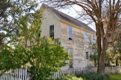 | Thomas Benton Hoover House | building | 1978 | 78002328 |
Every wildfire the federal occurrence database records inside this county: 1,160 of them, burning about 244,673 acres. 875 started naturally and 6 were recorded as arson. Each settlement page carries the fires within five miles of it.
| Reported cause | Fires |
|---|---|
| Natural | 875 |
| Recreation and ceremony | 111 |
| Debris and open burning | 49 |
| Equipment and vehicle use | 45 |
| Missing data/not specified/undetermined | 44 |
| Smoking | 20 |
| Arson/incendiarism | 6 |
| Power generation/transmission/distribution | 4 |
| Other causes | 3 |
| Misuse of fire by a minor | 2 |
| Fireworks | 1 |
The five largest, by the area the report gives. None of them was recorded as arson.
| Date | Cause | Size | Reported by | Name on the report |
|---|---|---|---|---|
| 17 August 2018 | Natural | 45,973 acres | Prineville District | JENNIES PEAK |
| 14 July 2014 | Natural | 30,251 acres | Prineville District | 0368 PINE CREEK |
| 10 August 1996 | Missing data/not specified/undetermined | 22,000 acres | Umatilla National Forest | WHEELER POINT |
| 20 June 2017 | Equipment and vehicle use | 15,200 acres | Prineville District | 0301 RHOADES CANYON |
| 24 August 2011 | Natural | 11,000 acres | Prineville District | 0494 |
| 18 July 2000 | Natural | 10,470 acres | Prineville District | 2 HORSE MT |
| 14 July 2014 | Natural | 10,277 acres | Oregon Department of Forestry Salem Headquarters | BAILEY BUTTE |
| 4 August 2000 | Debris and open burning | 7,900 acres | John Day Unit | TAMARACK CREEK |
Every settlement page carries the fires within five miles of it - see the settlement index below.
The NOAA Storm Events Database holds 48 reports for this county, causing 1 death, 1 injury and about $1,017,000 in recorded property damage. Each settlement page carries the reports that name it.
| Kind of event | Reports |
|---|---|
| Hail | 22 |
| Flood | 7 |
| Flash Flood | 6 |
| Thunderstorm Wind | 6 |
| Lightning | 2 |
| Heavy Rain | 2 |
| Wildfire | 2 |
| Tornado | 1 |
The most serious of them, by death, then injury, then recorded damage. The accounts are quoted exactly as the forecast office filed them.
| When | Event | Place named | Harm | What the report says |
|---|---|---|---|---|
| May 1997 | Lightning | Spray | 1 killed | A man and the horse he was riding were killed when they were struck by lightning on May Ridge. |
| June 2006 | Hail | Service Creek | 1 hurt | A group rafting the John Day River encountered large hail and strong winds at Burnt Ranch Rapids. Wind blown spume and spray from the river reduced visibility to 40 yards. One hail stone hit a rafter's head and caused swelling. |
| April 2019 | Flood | Spray | $1,000,000 | Numerous sections of Oregon Highway 19 and 207 were closed due to water over road and damage to road surfaces. Numerous county roads were damaged with rock and mudslides as well as plugged culverts. Flooding was reported in the city park in Spray. |
| June 2007 | Flash Flood | Richmond | $6,000 | Rainfall of 1.75 inches in 2 hours and 2.60 inches storm total. Public property damage occurred due to several county roads being washed out in the Twickenham area. |
| April 2019 | Flash Flood | Mitchell | $5,000 | Total rainfall of 1.67 inches was recorded just east of Mitchell. This heavy rain over a short period of time triggered a flash flood through Huddleston Heights and Nelson Street, and off of High Street and Rosenbaum with mud and debris blocking roads in and around the town of Mitchell. |
| April 2001 | Flash Flood | Spray | $5,000 | no account filed |
| August 2003 | Thunderstorm Wind | Fossil | $1,000 | A power pole was blown down due to strong winds. In addition, 0.50 inches of rain fell in 15-20 minutes. |
| July 2022 | Hail | Richmond | - | An amateur radio operator reported hail stones up to 1 inch in diameter 3 miles N of Spray, OR. |
| May 2020 | Flood | Service Creek | - | John Day River at Service Creek crested at 13.6 feet at 0900 on the 21st. Flood stage is 11.5 feet. |
| March 2017 | Flood | Spray | - | The John Day river near Service Creek, ( flood stage 11.5) crested at 12.0 feet at 1815 on March 16th, fell below flood stage and then rose again to 12.1 feet at 1900 on March 19th. Fell below flood stage 0600 on the 20th. |
| February 2017 | Flood | Service Creek | - | The John Day River at Service Creek briefly rose to 12.2 feet (flood stage is 11.5 feet). This was the result of an ice jam near Monument Oregon, blocking the river and then breaking free, sending the large volume of water downstream. |
| June 2017 | Hail | Clarno | - | Estimated hail of 1.00 inch reported at Hancock Field Station, 2 miles ENE of Clarno in Wheeler county. Very heavy rain with minor flooding also occurred. |
| June 2016 | Tornado (EF0) | Waterman | - | We received a lower quality cell phone video captured from the general public that showed what could potentially be a tornado. The observer felt very confident that it was. No damage reported as it was over rural area. |
| June 2016 | Thunderstorm Wind | Waterman | - | Driver witnessed the tornado then drove through the rear flank downdraft where they observed damaging wind gusts estimated to be 70 mph. |
| July 2012 | Hail | Mitchell | - | Hail accompanied by heavy rainfall and downed one tree limb. |
| April 2012 | Hail | Fossil | - | Observer also reported minor flooding on Butte Creek. The hail caused damage to an RV. |
| January 2011 | Flood | Spray | - | Only minor flooding observed. The John Day River at Service Creek crested at 13.72 which was 2.22 feet above flood stage. |
| May 2011 | Flood | Spray | - | The John Day River near Service Creek crested at 15.2 on May 17th, which was 3.7 feet above flood stage. |
| June 2010 | Flood | Service Creek | - | The John Day River at Service Creek crested at 12.5 feet on June 5 at 5 am. Flood stage is 11.5 feet. |
| August 2009 | Thunderstorm Wind | Service Creek | - | Spotter reported estimated gust to 65 mph. |
| August 2009 | Thunderstorm Wind | Service Creek | - | Trained spotter reported gust to 69 mph. |
| June 2009 | Thunderstorm Wind | Spray | - | Six large juniper trees were uprooted or split. Other trees lost large limbs. A 25 foot section of 1/8 inch steel panel was blown off a cow shelter. |
| June 2006 | Hail | Fossil | - | Power lines downed. |
| June 2006 | Hail | Service Creek | - | Hail accompanied by estimated 55 mph wind gust. |
| July 2002 | Wildfire | Richmond | - | The Priest Hole Fire was a lightning sparked fire which consumed 680 acres. |
| August 2002 | Flash Flood | Spray | - | Flash Flooding was reported between Spray and Service Creek. |
| July 2002 | Hail | Kinzua | - | Half-dollar size hail was reported by a weather spotter. |
| July 2001 | Lightning | Spray | - | Lightning caused a 6000 acre fire that burned for around 5 days near Sentinal Peak. |
| May 1998 | Heavy Rain | Waterman | - | A thunderstorm produced heavy rain and 1/4 inch hail that covered the ground in Mitchell. The heavy rain washed out some culverts along the west branch of Bridge Creek south of Mitchell. |
| May 1998 | Heavy Rain | Richmond | - | Heavy rain caused a mudslide that closed both lanes of Highway 26 thirty-eight miles east of Mitchell at mile post 26. |
| August 1998 | Wildfire | Clarno | - | More than 8,000 acres burned in the Clarno area. Warm temperatures, dry air, and wind hampered fire fighting efforts. One outbuilding and a private vehicle were destroyed by the fire. Three air tankers and a helicopter were used to help put out the fire. |
| July 1998 | Hail | Fossil | - | Dize sized hail fell in Fossil with heavy rain. |
| July 1998 | Flash Flood | Northeast Portion | - | A three foot wall of water came down Alder Creek and the water level stayed up for two and a half hours. |
| August 1997 | Hail | Winlock | - | Weather spotters reported hail between 0.5 and 1.25 inches. |
| May 2020 | Hail | Spray | - | no account filed |
| June 2016 | Hail | Waterman | - | no account filed |
| May 2015 | Hail | Fossil | - | no account filed |
| June 2015 | Hail | Spray | - | no account filed |
| August 2007 | Hail | Winlock | - | no account filed |
| June 2006 | Hail | Service Creek | - | no account filed |
| June 2006 | Hail | Service Creek | - | no account filed |
| June 2004 | Flash Flood | Mitchell | - | no account filed |
| July 2004 | Thunderstorm Wind | Mitchell | - | no account filed |
| August 2004 | Hail | Fossil | - | no account filed |
| August 2003 | Hail | Mitchell | - | no account filed |
| June 1999 | Hail | Fossil | - | no account filed |
| June 1999 | Hail | Fossil | - | no account filed |
| April 1957 | Hail | not stated | - | no account filed |
The Survey's mineral resources record lists 98 workings inside this county. 24 still produce and 74 are closed or unrecorded. Each settlement page carries the workings within five miles of it.
| Commodity | Workings |
|---|---|
| Stone | 26 |
| Stone, Crushed/Broken | 22 |
| Mercury | 16 |
| Gold | 13 |
| Zeolites | 5 |
| Sand and Gravel, Construction | 4 |
| Uranium | 3 |
| Silver | 2 |
| Gemstone | 2 |
| Silica | 2 |
| Gold, Copper, Lead | 1 |
| Gold, Copper, Silver, Lead | 1 |
| Lead, Zinc | 1 |
| Gold, Silver | 1 |
The least common of them first, because a county's hundredth gravel pit says nothing its first ten did not.
| Where | Site | Commodity | Status | Recorded |
|---|---|---|---|---|
| Birch Creek Mining Co. | Gold, Silver, Lead, Zinc | Occurrence | Galena, Pyrite, Sphalerite | |
| Birch Creek Mining Co. Property | Gold, Lead, Zinc, Silver | Prospect | ||
| Rosa D. | Gold, Silver | Occurrence | ||
| Shoo Fly Creek | Limestone, General | Occurrence | ||
| Spanish Gulch Placers | Gold, Platinum, Silver, Chromium | Producer | Chromite, Gold | |
| Spanish Gulch Placers | Gold, Chromium, PGE, Silver | Past Producer | ||
| Spanish Gulch Project/Andrews Mine | Gold, Copper, Silver, Lead | Past Producer | Vein | |
| Spanish Gulch Project/Andrews Mine | Gold, Silver, Lead, Copper | Prospect | ||
| Unnamed Quarry | Semiprecious Gemstone | Past Producer | ||
| Waterman Mine | Gold, Lead, Copper | Past Producer | ||
| Waterman Prospect | Gold, Copper, Lead | Occurrence | Bornite, Chalcopyrite, Galena, Pyrite | |
| Agate Claim | Gemstone | Past Producer | ||
| Antone Quartz Blowout | Silica | Occurrence | ||
| Antone Quartz Blowout | Silica | Occurrence | ||
| Crystal Peak | Gemstone | Occurrence | ||
| Rosa D. | Gold, Silver | Past Producer | ||
| Unknown | Uranium | Occurrence | ||
| Unnamed Uranium Occurrence | Uranium | Occurrence | ||
| Uranium Occurrence | Uranium | Occurrence | ||
| Gravel Pit | Sand and Gravel, Construction | Past Producer | ||
| Spray/Kimberly Hwy | Sand and Gravel, Construction | Past Producer | ||
| Spray/Kimberly Hwy Pit | Sand and Gravel, Construction | Producer | ||
| Unnamed Pit | Sand and Gravel, Construction | Producer | ||
| Deep Creek Tuff | Zeolites | Occurrence | Clinoptilolite | |
| Deep Creek Tuff | Zeolites | Occurrence | ||
| Dutch Flat Tuff | Zeolites | Unknown | ||
| Parrish Creek Tuff | Zeolites | Unknown | ||
| Squaw Creek Tuff | Zeolites | Unknown | ||
| Gold Prospect | Gold | Occurrence | ||
| Rock & Birch Creek Placers | Gold | Past Producer | ||
| Rock & Burch Creek Placers | Gold | Past Producer | ||
| Unnamed Prospect | Gold | Occurrence | ||
| Unnamed Prospect | Gold | Past Producer | ||
| Waterman 1-10 | Gold | Past Producer | ||
| Bear Claims | Mercury | Occurrence | Cinnabar, Limonite, Pyrite | |
| Bear Claims | Mercury | Prospect | ||
| Beaver Guard | Mercury | Occurrence | Cinnabar, Limonite | |
| Beaver Guard Prospect | Mercury | Prospect | ||
| Gage Ranch | Mercury | Occurrence | 1940 | |
| Gage Ranch Prospect | Mercury | Occurrence | ||
| Howard Ranch | Mercury | Occurrence | ||
| Howard Ranch Prospect | Mercury | Occurrence | ||
| Lucky Lost | Mercury | Occurrence | ||
| Lucky Lost Mine | Mercury | Occurrence | ||
| Mc Timmonds Ranch | Mercury | Occurrence | 1938 | |
| Mctimmonds Ranch Prospect | Mercury | Prospect | ||
| Mercury King | Mercury | Occurrence | Cinnabar | |
| Mercury King Prospect | Mercury | Prospect | ||
| Ribelin | Mercury | Occurrence | 1930 | |
| Ribelin Prospect | Mercury | Prospect | ||
| Antone Junction Pit | Stone, Crushed/Broken | Producer | ||
| Cripple Creek Vien | Stone, Crushed/Broken | Prospect | ||
| Dry Gulch Bridge | Stone, Crushed/Broken | Producer | ||
| Fossil Rock Products Pit | Stone, Crushed/Broken | Producer | ||
| Mortimer Pit | Stone, Crushed/Broken | Producer | ||
| Mortimer Ranch Pit | Stone, Crushed/Broken | Producer | ||
| Mp 93.3 Spray/Kimberly Hwy | Stone, Crushed/Broken | Producer | ||
| Ordway Pit | Stone, Crushed/Broken | Producer | ||
| Painted Hill Pit | Stone, Crushed/Broken | Producer | ||
| Spray Rock Production Pit | Stone, Crushed/Broken | Producer | ||
| Unnamed Pit | Stone, Crushed/Broken | Producer | ||
| Unnamed Pit | Stone, Crushed/Broken | Producer | ||
| Unnamed Pit | Stone, Crushed/Broken | Producer | ||
| Unnamed Pit | Stone, Crushed/Broken | Producer | ||
| Unnamed Pit | Stone, Crushed/Broken | Producer | ||
| Unnamed Pit | Stone, Crushed/Broken | Producer | ||
| Unnamed Pit | Stone, Crushed/Broken | Producer | ||
| Unnamed Pit | Stone, Crushed/Broken | Producer | ||
| Unnamed Pit | Stone, Crushed/Broken | Producer | ||
| Unnamed Pit | Stone, Crushed/Broken | Producer | ||
| Unnamed Pit | Stone, Crushed/Broken | Producer | ||
| Unnamed Quarry | Stone, Crushed/Broken | Prospect | ||
| Antone Junction | Stone | Past Producer | ||
| Basalt Quarry | Stone | Past Producer | ||
| Basalt Quarry | Stone | Past Producer | ||
| Basalt Quarry | Stone | Past Producer | ||
| Basalt Quarry | Stone | Past Producer | ||
| Dry Gulch Bridge | Stone | Past Producer | ||
| Fossil Rock Product | Stone | Past Producer | ||
| Mortimer Pit | Stone | Past Producer | ||
| Mortimer Ranch | Stone | Past Producer | ||
| Mp 93.3 Spray/Kimberly | Stone | Past Producer | ||
| Ordway Pit | Stone | Past Producer | ||
| Painted Hill | Stone | Past Producer | ||
| Quarry | Stone | Past Producer | ||
| Quarry | Stone | Past Producer | ||
| Quarry | Stone | Past Producer | ||
| Quarry | Stone | Past Producer | ||
| Quarry | Stone | Past Producer | ||
| Quarry | Stone | Past Producer | ||
| Quarry | Stone | Past Producer | ||
| Quarry | Stone | Past Producer | ||
| Richard Rock/Mitchell-Service Cr. | Stone | Producer | ||
| Richland Rock/Mitchell-Service Creek Hwy | Stone | Past Producer | ||
| Shoo Fly Creek | Stone | Past Producer | ||
| Slide Mountain Quarry | Stone | Past Producer | ||
| Spray Rock Production | Stone | Past Producer | ||
| Unnamed Quarry Quarry | Stone | Past Producer |
Named settlements recorded in the Geographic Names Information System, each with the topographic sheets covering it. Villages, hamlets and abandoned places alike. Each is shown with the nearest named watercourse or landform and the survey quadrangle it falls on.
Mitchell census division · 97750 · On Fred Creek · Antone quadrangle
15 sheets, 1932 to 1992
No longer a settlement
Mitchell census division · 97750 · Near Rhine Hollow · Frog Hollow quadrangle
10 sheets, 1953 to 1990
No longer a settlement
Fossil census division · 97830 · On Cottonwood Creek · Fossil South quadrangle
11 sheets, 1926 to 1987
Fossil census division · 97830 · On Searcy Creek · Kinzua quadrangle
11 sheets, 1926 to 1987
No longer a settlement
Fossil census division · 97830 · Lonerock quadrangle
9 sheets, 1953 to 1995
No longer a settlement
Mitchell census division · 97750 · On Keyes Creek · Mitchell quadrangle
13 sheets, 1926 to 1992
Mitchell census division · 97874 · On Cary Creek · Richmond quadrangle
10 sheets, 1953 to 1990
Mitchell census division · 97830 · On Service Creek · Service Creek quadrangle
11 sheets, 1926 to 1987
Mitchell census division · 97750 · On Keeton Creek · Frog Hollow quadrangle
10 sheets, 1953 to 1990
Mitchell census division · 97750 · Near James Canyon · Sutton Mountain quadrangle
12 sheets, 1926 to 1987
Mitchell census division · 97874 · On Tamarack Creek · Toney Butte quadrangle
12 sheets, 1926 to 1988
No longer a settlement
Mitchell census division · 97750 · On Waterman Flat · Frog Hollow quadrangle
10 sheets, 1953 to 1990
No longer a settlement
The vanished settlements of Wheeler County: the places named above that are no longer on the map.