BlockBefore

John and Elizabeth Kinsman House

Built in 1963 (modern architecture). Listed on the National Register of Historic Places in 2021.

From the record

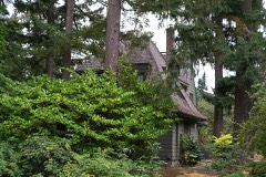
“The John and Elizabeth Kinsman House is a historic house near Milwaukie, Oregon, United States. Completed in 1964, it is a locally significant and almost unaltered example of the Contemporary Style of the late 1950s and early 1960s, which emphasized local materials and indoor-outdoor living and rejected continuity with earlier stylistic conventions.”

Wikipedia article John and Elizabeth Kinsman House, CC BY-SA 4.0.

One of 93 National Register listings published here for Clackamas County · listed in 2021 · category: Building · built in 1963, modern architecture.

Sources: the Wikipedia article · the National Register database, National Park Service
The listing

  • What is counted as historic. The nomination lists 3 buildingss, 1 site as contributing to the listing.
  • Listed as. Kinsman, John and Elizabeth, House - the National Register files a house under its owner's surname.
  • Address. 17014 SE Oatfield Rd., Milwaukie, 97267
  • When was it listed? February 2021
  • Category. building
  • Census division. Northwest Clackamas
  • When was it built? 1963
  • Architectural style. modern architecture
  • National Register reference number. 100006185 - assigned by the National Park Service when the property was listed.

Mines and quarries near this property

10 of 48 shown

Regional context, not property-specific evidence. The federal mineral resources record lists 48 workings within 5 miles of John and Elizabeth Kinsman House: 32 past producers, 14 producers, 2 occurrences. 14 still produce. What was taken out: Sand and Gravel, Construction, Stone, Stone, Crushed/Broken, Silica. Distance is straight-line from the map coordinates, so a quarry counted here may appear on a neighbouring settlement's page as well.

Where SiteCommodity StatusRecorded
Oswego Iron MineIronPast Producer1867, 1894
Oswego Iron MineIronPast Producer
Francis Welsh Silica MineSilicaOccurrence
Francis Welsh Silica MineSilicaPast Producer
Grimms Fuel Co. PitStone, Crushed/BrokenPast Producer
Lake Oswego Pit and PlantStone, Crushed/BrokenProducer
Pynns Rock QuarryStone, Crushed/BrokenProducer
Seventh Day AdventistsStone, Crushed/BrokenProducer
Terrill Silica DepositSilicaOccurrence
Terrill Silica DepositSilicaPast Producer

Every working recorded in Clackamas County

Storms near this property

2 since 2009

Regional context, not property-specific evidence. The National Weather Service names Milwaukie, the town this property stands in, in 2 storm reports between 2009 and 2022: 1 thunderstorm wind, 1 heavy rain. No death or injury is recorded in these reports. Each account below is quoted exactly as the forecast office filed it, from the NOAA Storm Events Database, and each date opens the federal record of that event.

WhenEvent Place namedHarm What the report says
June 2022Heavy RainMilwaukie-Heavy rain caused a sewage overflow into the Willamette River in Milwaukie.
May 2009Thunderstorm WindMilwaukie-A severe thunderstorm moved through the area, producing strong winds, 3/4 inch hail, and downed a few trees. Approximately 30,000 people in the Portland metro area lost power due to downed power lines. Near Tualatin, a man was killed after a limb blown down by strong winds fell onto his car.

Every storm recorded in Clackamas County

Map coverage status

No historic map-sheet match is published for this property yet. That does not mean no map exists. This record needs a coordinate-quality review before it can be joined to a sheet boundary. Browse the county's mapped places while that work is pending.

Listed places nearby

6 within 8 miles

Other National Register properties close enough to walk or drive between, ordered by distance from this one. Both positions come from the same geocoding pass that matched these properties to their map sheets.

Photograph PropertyDistance Listed
John F. and John H. Broetje House2.0 miles1987
Hiram A. Straight House2.1 miles1978
Marshall Dana House2.2 miles1992
Dr. Edward and Anne McLean House2.5 miles2025
Erwin Charles Hackett House2.5 miles1985
Lawrence D. Bailey House2.7 miles1990

Sources for this property

National Archives recordThe nomination case file for reference 100006185 in Record Group 79.
Wikipedia articleCommunity-written account of this property, licensed CC BY-SA.
Clackamas CountyAll 93 listed properties in this county.

Provenance

  • Listing record. National Park Service National Register of Historic Places, listed-properties dataset, current to 2026-05-22.
  • Map join. Address geocoded through the United States Census geocoder, then tested against the published boundary of every sheet in the USGS Historical Topographic Map Collection.
  • How this page is made. Listing fields come from federal records; map-sheet coverage is a labelled coordinate-to-boundary calculation, not a source-field claim.
  • Mines and quarries. USGS Mineral Resources Data System (MRDS) https://mrdata.usgs.gov/mrds/ A work of the United States government, no copyright under 17 U.S.C. 105.
  • Storms. NOAA National Centers for Environmental Information, Storm Events Database https://www.ncei.noaa.gov/stormevents/ A work of the United States government, no copyright under 17 U.S.C. 105. Narratives are quoted verbatim from the National Weather Service report and are not edited or summarised.