
BlockBefore
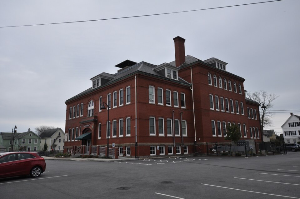
Photograph of Robert C. Ingraham School
Photograph by User:Magicpiano, CC BY-SA 4.0. Via Wikimedia Commons.

Ingraham, Robert C., School

Built in 1901. Listed on the National Register of Historic Places in 2010. A historic map-sheet match is not published yet. The record needs a coordinate-quality review before it can be joined to a sheet boundary.

From the record

“Criteria Statement: The Ingraham School is a Romanesque Revival building constructed in that has retained much of its original historical significance and architectural integrity. Built during New Bedford's prosperous industrial age, the structure was part of a community development effort to accommodate the educational needs of an exploding immigrant population in the south end of New Bedford.”

Narrative Statement of Significance, National Register nomination for Ingraham, Robert C., School. Machine-read text.

one of 272 National Register listings in Bristol County · listed in 2010 · category: Building · built in 1901 · one of 8 National Historic Landmarks in Bristol County.

Sources: the nomination case file at the National Archives · the full case file on this site · the National Register database, National Park Service · the Wikipedia article

The listing

  • What is counted as historic. The nomination lists 1 building as contributing to the listing.
  • Address. 80 Rivet St., New Bedford, 03851
  • When was it listed? 2010-03-02
  • Category. building
  • When was it built? 1901
  • National Register reference number. 10000056 - the number the National Park Service assigned this property when it was listed, and the key its nomination file is catalogued under at the National Archives.

Storms near this property

22 since 1996

Regional context, not property-specific evidence. The National Weather Service names New Bedford, the town this property stands in, in 22 storm reports between 1996 and 2023: 11 flood, 4 thunderstorm wind, 3 flash flood, 2 heavy rain. The reports record 1 death. Each account below is quoted exactly as the forecast office filed it, from the NOAA Storm Events Database, and each date opens the federal record of that event.

WhenEvent Place namedHarm What the report says
May 1996Thunderstorm WindNew Bedford1 killedno account filed
March 2008FloodNew Bedford$50,000The Swansea Mall parking lot flooded. In New Bedford: Acushnet Avenue and one lane of Route 18 North were closed due to flooding at their intersections with Hillman Street, Acushnet Avenue was also flooded at Wamsutta Street, Buttonwood Brook went out of its banks flooding several yards on Hawthorne Street, Sawyer and Purchase Streets were flooded. Several basements flooded on Riverside Avenue in Somerset. In Fall River: McGee and Cedar Streets, New Boston Road, and Eastern Avenue were flooded with vehicles stuck in flood waters. In addition, numerous basements were flooded. Union Street and Burt Street near Tremont Street were flooded in Taunton.
August 2006Thunderstorm WindNew Bedford$25,000no account filed
September 2021FloodNew Bedford$20,000Several streets were closed due to flooding and several basements were flooded, but there were no evacuations needed in the city.
March 2014FloodNew Bedford$20,000Flooding continued after three to five inches of rain fell across the region earlier in the day. In New Bedford, Parker Street near New Bedford High School was closed due to continued flooding. Dartmouth Street was washed out between Rockland and Spooner Streets. The road was closed for repairs as the asphalt washed away. In Acushnet, Main Street near Clems Way was flooded and impassable.
December 2012FloodNew Bedford$15,000Flooding was reported in New Bedford on parts of Route 18, Purchase Street, and at the intersection of Rockdale, Coggeshall and Sawyer Streets. Route 18 was closed in both directions for a time because of water up to 30 inches deep flooding the roadway. The I-195 eastbound exit ramp to Route 18 South was closed for a brief time due to water covering the roadway. In Fairhaven, flooding affected Route 6 at Green Street as well as on Bridge and Spring Streets, where as much as 18 inches of water covered the road. Two cars were stranded on Adams Street after attempting to drive through the flooded roadway.
August 2005Flash FloodNew Bedford$15,000no account filed
July 2015FloodNew Bedford$5,000Minor street flooding occurred along Route 18 by the Royal restaurant and Tarkiln Hill Road and Kings Highway. A car was stuck in flood waters at Weld Street and Route 18.
August 2008Thunderstorm WindNew Bedford$5,000Trees on Peckham Road were downed by thunderstorm winds.
August 2005Flash FloodNew Bedford$5,000no account filed
June 1997LightningNew Bedford$2,000no account filed
September 2022Flash FloodNew Bedford$1,000In New Bedford, Dartmouth Street at Rockdale Avenue was flooded to the point where DPW assistance was required. Padanaram Ave. was also flooded. Report relayed by amateur radio.
August 2023FloodNew Bedford-In New Bedford, there were several reports of vehicles stuck in flooding on Orchard St and River St with flooding also on Dartmouth St at Hickory St.
October 2019FloodNew Bedford-In New Bedford, Cove Road was closed from Stapleton Street to County Street, due to a reported 2.5 feet of flooding.
October 2019FloodNew Bedford-In New Bedford, flooding closed Rivet Street between Briggs Street and Orchard Street.
January 2018FloodNew Bedford-At 1252 AM, Kempton Street was reported flooded and impassable between Rockdale Avenue and Jenny Lind Street.
June 2010FloodNew Bedford-Portions of Acushnet Avenue (Route 18) and Coggeshall Street were closed near Interstate 195 due to flooding. Several cars were stuck in flood waters on Route 6 near Route 140.
February 2008FloodNew Bedford-Several roads were closed due to flooding in New Bedford. Some of these include: Coggeshall Street, portions of Route 18, and Sawyer Street. In Somerset, Buffington Brook went out of its banks, flooding County Street and a nearby park.
July 2007Thunderstorm WindNew Bedford-Trees and wires down in the South End.
March 2000Heavy RainNew Bedford-no account filed
June 1998HailNew Bedford-no account filed
October 1998Heavy RainNew Bedford-no account filed

Every storm recorded in Bristol County

Map coverage status

No historic map-sheet match is published for this property yet. That does not mean no map exists. This record needs a coordinate-quality review before it can be joined to a sheet boundary. Browse the county's mapped places while that work is pending.

From the nomination file

10,368 words on record

When this property was proposed for the National Register, someone wrote the case for it: what the building is, and why it matters. That document is a federal record in the public domain. It is quoted below word for word, never summarised. The text was read off the scanned case file by machine, so the occasional stray character is the recogniser's and the 1970s typewriter's.

Statement of significance

Applicable National Register Criteria Mark "x" in one or more boxes for the criteria qualifying the propert or National Register listing B Property is associated with events that have made a significant contribution to the broad patterns of our history. Property is associated with the lives of persons significant in our past. C Property embodies the distinctive characteristics of a type, period, or method of construction or represents the work of a master, or possesses high artistic values, or represents a significant and distinguishable entity whose components lack individual distinction. Property has yielded, or is likely to yield, information important in prehistory or history.

Bristol, MA County and State Areas of Significance (Enter categories from instructions) ARCHITECTURE COMMUNITY PLANNING AND DEVELOPMENT EDUCATION Period of Significance 1900-1960 Significant Dates 1901- school opened Criteria Considerations (Mark "x" in all the boxes that apply) Property is: A owed by a religious institution or used for religious purposes. B removed from its original location. C a birthplace or grave. a cemetery. E a reconstructed building, object, or structure. F a commemorative property. G less than 50 years old or achieving significance within the past 50 years. Significant Person N/A Cultural Affiliation N/A Architect/Builder Samuel C.

Hunt Period of Significance (justification) In 1900, the city of New Bedford acquired land from the Potomska Mill Corporation with the intent of constructing a new school. The city commissioned architect Samuel C. Hunt to design that building. following year, the completed Robert C. Ingraham School opened its doors in September of 1901. The school was full to capacity upon opening and continued to function as part of the New Bedford public school system until the 1970s, when a larger school was constructed. (see continuation sheet) NPS Form 10-900 (Rev.

Read the complete 10,368-word case file.

The whole case file for this property - 10,368 words, 58 pages, reproduced complete.

Quoted from the National Register nomination for reference 10000056, 58 pages, held by the National Archives in Record Group 79. See the catalogue record.

Sources for this property

National Archives recordThe nomination case file for reference 10000056 in Record Group 79.
Wikipedia articleCommunity-written account of this property, licensed CC BY-SA.
Bristol CountyAll 272 listed properties in this county.

Provenance

  • Listing record. National Park Service National Register of Historic Places, listed-properties dataset, current to 2026-05-22.
  • Map join. Address geocoded through the United States Census geocoder, then tested against the published boundary of every sheet in the USGS Historical Topographic Map Collection.
  • How this page is made. Listing fields come from federal records; map-sheet coverage is a labelled coordinate-to-boundary calculation, not a source-field claim.
  • Storms. NOAA National Centers for Environmental Information, Storm Events Database https://www.ncei.noaa.gov/stormevents/ A work of the United States government, no copyright under 17 U.S.C. 105. Narratives are quoted verbatim from the National Weather Service report and are not edited or summarised.