Listed on the National Register of Historic Places in
1974. A historic map-sheet match is not published yet. The record needs a coordinate-quality review before it can be joined to a sheet boundary.
From the record
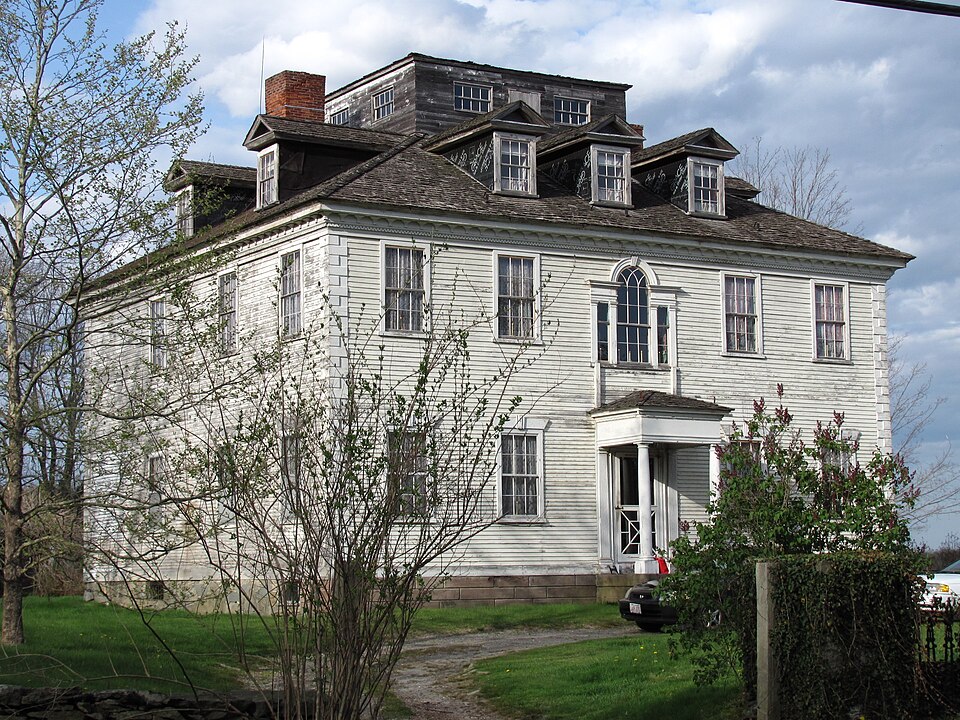
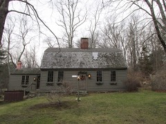
“The Martin House is a historic house in Seekonk, Massachusetts, United States.”
Wikipedia article Martin House (Seekonk, Massachusetts), CC BY-SA 4.0.
one of 272 National Register listings in Bristol County · listed in 1974 · category: Building · one of 8 National Historic Landmarks in Bristol County.
National Register reference number.74000365- the number the National Park Service assigned this property when it was listed, and the key its nomination file is catalogued under at the National Archives.
Seekonk lies in the northwestern part of the county, and is bounded as follows: On the north by Attleborough, on the east by Rehoboth, on the south by Swansea, and on the west by East Providence and Pawtucket. The territory embraced within the present town of Seekonk originally formed a portion of the ancient town of Rehoboth, where the record history, names of early settlers, etc., will be found.
Nov. 12, 1812, it was "voted to choose by nomination a committee of three to divide all public personal property that belongs to the towns of Seekonk and Rehoboth, and poor persons, agreeable to the act of the General Court of this commonwealth incorporating Seekonk, and choose James Ellis, Esq., and Deacon Joseph Bucklin as said committee."
Regional context, not property-specific
evidence. The
federal wildfire occurrence database
lists 38 fires within 5 miles of Martin House between
2006 and 2020, burning about 50 acres in total. None started naturally. 8 were recorded as arson.
Distance is straight-line from the map coordinates, so a fire counted
here may appear on a neighbouring settlement's page as well.
Reported cause
Fires
Missing data/not specified/undetermined
17
Arson/incendiarism
8
Debris and open burning
7
Misuse of fire by a minor
2
Smoking
2
Power generation/transmission/distribution
1
Recreation and ceremony
1
The most recent of
them, most recent first, with the day each was reported and the service
that recorded it.
Regional context, not property-specific
evidence. Museums hold 1,196 specimens
collected within 10 miles of Martin House between 1844 and
1975: 655 Plantae, 414 Animalia, 98 Fungi, 26 Chromista, 3 Unrecorded. 12 distinct Species records are shown.
Collected by A E Schuyler, A., A. E. Sears and others. Each is a
physical object with a catalogue
number, and each entry opens the museum's record. This is what was
collected and kept, not a survey of what lives here - nothing can be
concluded from a species being absent.
Regional context, not property-specific
evidence. The federal mineral resources record lists
2 workings within 5 miles of Martin House: 1 past producer, 1 producer.
1 still produces. What was taken out: Sand and Gravel, Construction. Distance is straight-line from the
map coordinates, so a quarry counted here may appear on a neighbouring
settlement's page as well.
Regional context, not property-specific
evidence. The National Weather Service names
Seekonk, the town this property stands in, in 16 storm reports between 1996 and 2024: 6 hail, 5 thunderstorm wind, 3 lightning, 1 flood.
The reports record 1 injury. Each account below is quoted exactly as the forecast office
filed it, from the NOAA Storm Events Database, and each date
opens the federal record of that event.
A storm survey indicated a microburst with winds estimated at 100 mph downed and snapped many trees in a wooded area near Seekonk High School and in a school courtyard which caused damage to the roof.
A tornado touched down in a wooded area west of Steber Way in|Rehoboth, MA. A number of large hardwood and softwood trees were|snapped and uprooted in the woods and in several yards along the|path. Otherwise, there was no significant damage to homes. The|tornado reached a maximum intensity of 90 mph. The maximum width|of the tornado was 50 yards. This was a very short lived tornado|which was only on the ground for one minute.
No historic map-sheet match is published
for this property yet. That does not mean no map exists. This record needs
a coordinate-quality review before it can be joined to a sheet boundary.
Browse the county's mapped places while that work is
pending.
From the nomination file
2,141 words on record
When this property was proposed for the
National Register, someone wrote the case for it: what the building is,
and why it matters. That document is a federal record in the public domain.
It is quoted below word for word, never summarised. The text was read off the scanned case file by machine, so the
occasional stray character is the recogniser's and the 1970s
typewriter's.
Description of the property
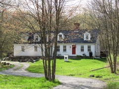
- Moved - Unexposed (Check One) X Original Site The Martin House, c.1799, sits elegantly atop Chestnut Hill in Seekonk, overlooking a landscape of gently rolling farmland and the Palmer River. A fine example of an elegant Federal mansion, it is five bays wide. Originally all clapboard, it is now covered on two sides with white clap- board and on two other sides with white shingles. It is topped by a hip roof with one chimney set in from either side. The house foundation and entrance steps are granite faced with brownstone. The main frame of the house is made up of handhewn 7" x 7" pegged oak members; the 3"x4" studding is tenoned into the main frame at 20" intervals, and the bracing is morticed and tenoned into the major uprights. The house has been altered considerably on the exterior.
In 1880 a covered veranda was added on the east side. At the same time, the rear entrance with pediment and fluted pilasters was removed so that a kitchen ell could be added on the north side. The ell was designed in the Federal style with a gable roof and two dormers. It is two bays deep, three bays long, and is quoined at the corners.Also in 1880 the original six over six window sashes were changed to two over two, the shutters were removed from all but the facade, and shingle replaced clapboard on the east and north elevations. In 1957 seven original dormers and an 18' square monitor were removed fxom the roof along with the Chinese Chippendale style ballustrade. The. elegant roof entablature consists of Greek fretwork topped by shallow flared brackets and a boxed cornice.
On the east side of Chestnut Hill, surrounded by farmland and overlooking the Palmer River, stands the magnificent home of Simeon Martin. The 1799 house is architecturally significant not only because/it is a city mansion in a rural farm setting, but because it is the only Federal mansion in Seekonk. Most of the elegant exterior woodwork and all of the interior woodwork have been preserved, and the interior cornice and chair- rail mouldings have been sited by Antoinette Downing as unique to this house. Historically, the house is significant because both Simeon Martin and his father were 'involved in state and local government, silvanus as a Rehoboth selectman and Simeon as the Lieutenant Governor of Rhode Island.
In 1799 Simeon Martin returned from service in the Revolutionary War and began a political career in Newport, R.I. In the same year, he went to Rehoboth (which became Seekonk in 1812) and built his house on the family property where he had grown up. His father, Silvanus Martin, whose house was dismantled in the early 20th c., had been a gentleman farmer and se lectman of Rehoboth for twenty years. while the architect and craftsmen of the Martin House are unknown, it is likely that Simeon brought them from Newport, as the house resembles, in style and detail, many other Federal mansions in Newport. It is also unknown why Martin built such an elegant Federal mansion in the farm area of Rehoboth.
Perhaps he did not anticipate a long political career in Newport, but nevertheless, Martin did spend the next seventeen years in political service in Newport, renting the house out to his brothers in the meanwhile. During the period 1799-1819, Simeon Martin held the offices of Adjutant General and Major General of the State of Rhode Island.
Quoted from the National Register nomination
for reference 74000365, 10 pages, held by the National Archives in Record
Group 79. See the
catalogue record.
Listed places nearby
6 within 8 miles
Other National Register properties close
enough to walk or drive between, ordered by distance from this one. Both
positions come from the same geocoding pass that matched these properties
to their map sheets.
Listing record. National Park Service National Register of Historic Places, listed-properties dataset, current to 2026-05-22.
Map join. Address geocoded through the United States Census geocoder, then tested against the published boundary of every sheet in the USGS Historical Topographic Map Collection.
How this page is made. Listing fields come from federal records; map-sheet coverage is a labelled coordinate-to-boundary calculation, not a source-field claim.
Wildfire. Short, Karen C. 2022. Spatial wildfire occurrence data for the United States, 1992-2020 [FPA_FOD_20221014]. 6th Edition. Fort Collins, CO: Forest Service Research Data Archive. https://doi.org/10.2737/RDS-2013-0009.6 Collected with United States Government funding and usable without additional permissions or fees.
Specimens. Global Biodiversity Information Facility (GBIF), https://www.gbif.org/. Only records licensed CC0 or CC BY are used. Records licensed CC BY-NC are excluded because this site carries advertising. Images are checked individually and any whose licence is non-commercial, no-derivatives or unreadable is refused.
Mines and quarries. USGS Mineral Resources Data System (MRDS) https://mrdata.usgs.gov/mrds/ A work of the United States government, no copyright under 17 U.S.C. 105.
Storms. NOAA National Centers for Environmental Information, Storm Events Database https://www.ncei.noaa.gov/stormevents/ A work of the United States government, no copyright under 17 U.S.C. 105. Narratives are quoted verbatim from the National Weather Service report and are not edited or summarised.
 Block
Block