Listed on the National Register of Historic Places in
1974. A historic map-sheet match is not published yet. The record needs a coordinate-quality review before it can be joined to a sheet boundary.
From the record
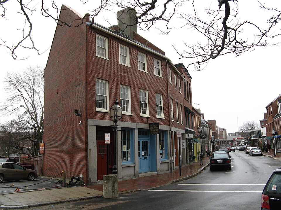
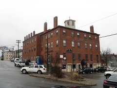
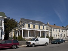
“The Front Street Block is a series of four connected commercial blocks in the West End of Gloucester, Massachusetts, USA. They were built in 1831 after a fire had devastated Gloucester's downtown the previous year.69-71 Main Street, a three-story four wide block with Federalist styling, was built for Aaron Day.”
Wikipedia article Front Street Block, CC BY-SA 4.0.
one of 350 National Register listings in Essex County · listed in 1974 · category: District · one of 2 National Historic Landmarks in Essex County.
National Register reference number.74000369- the number the National Park Service assigned this property when it was listed, and the key its nomination file is catalogued under at the National Archives.
Fires near this property
24 since 2015
Regional context, not property-specific
evidence. The
federal wildfire occurrence database
lists 24 fires within 5 miles of Front Street Block between
2015 and 2020, burning about 19 acres in total. None started naturally. 5 were recorded as arson.
Distance is straight-line from the map coordinates, so a fire counted
here may appear on a neighbouring settlement's page as well.
Reported cause
Fires
Recreation and ceremony
10
Arson/incendiarism
5
Smoking
4
Debris and open burning
3
Misuse of fire by a minor
1
Equipment and vehicle use
1
The most recent of
them, most recent first, with the day each was reported and the service
that recorded it.
Regional context, not property-specific
evidence. Museums hold 5,145 specimens
collected within 10 miles of Front Street Block between 1817 and
1975: 2,116 Animalia, 1,366 Plantae, 1,037 Fungi, 326 Chromista, 189 Unrecorded, 91 Protozoa, 20 Bacteria. 12 distinct Species records are shown.
Collected by A H HIGGINSON, A Perlmutter, A. A. Eaton and others. Each is a
physical object with a catalogue
number, and each entry opens the museum's record. This is what was
collected and kept, not a survey of what lives here - nothing can be
concluded from a species being absent.
Regional context, not property-specific
evidence. The federal mineral resources record lists
6 workings within 5 miles of Front Street Block: 6 past producers.
None of them still produces. What was taken out: Sand and Gravel, Construction, Granite. Distance is straight-line from the
map coordinates, so a quarry counted here may appear on a neighbouring
settlement's page as well.
Regional context, not property-specific
evidence. The National Weather Service names
Gloucester, the town this property stands in, in 10 storm reports between 1997 and 2020: 6 thunderstorm wind, 2 lightning, 1 heavy rain, 1 flood.
No death or injury is recorded in these reports. Each account below is quoted exactly as the forecast office
filed it, from the NOAA Storm Events Database, and each date
opens the federal record of that event.
No historic map-sheet match is published
for this property yet. That does not mean no map exists. This record needs
a coordinate-quality review before it can be joined to a sheet boundary.
Browse the county's mapped places while that work is
pending.
From the nomination file
2,681 words on record
When this property was proposed for the
National Register, someone wrote the case for it: what the building is,
and why it matters. That document is a federal record in the public domain.
It is quoted below word for word, never summarised. The text was read off the scanned case file by machine, so the
occasional stray character is the recogniser's and the 1970s
typewriter's.
Description of the property
The Front Street Block is a group of four buildings that were constructed soon after Gloucester's first Great Fire which, on September 16, 1830, destroyed all of the structures between Front Street and the harbor, an area containing many of the busi- ness establishments of the town. Work is believed to have started on them in 1831.
Assessors records show increases of between 60% and 90% in the valuations of these four properties from 1831 to 1833, and one assessor's entry of 1833 specifically mentions "Brick Building, Front Street" under the real estate holdings of Henry Smith, then owner of the present #55-59 Main ES25267 Since none of the common party walls between the buildings could ever have been used as an exterior wall (due to the unpointed and unsealed mortar between the bricks) and con- sidering the simultaneous increase in assessed valuations of all four parcels /of land, it appears that all of the buildings were built by 183ß.
In any case, a map of Gloucester's waterfront that all four brick buildings were completed by 1845- The four buildings were designed in a smoothly coordinated Federalist style, though one was later substantially altered. Brick is the principal building material, with granite framing the entryways and separating the street level from the apper floors, creating a pleasing contrast. One pair of buildings is three stories high, and the remaining pair was two stories -- though one of this pair was updated in 1890 with a Victorian facade, becoming three stories high -- with individual hip roofs now covering three of the buildings and party walls extending beyond the moderately pitched roof line.
Accenting the clean lines of the roof are four massive brick chimneys 'and four smal- ler ones necessary to accommodate the many fireplaces of the four buildings.
The significance of the buildings of the Front Street Block lies in two areas. First, from a purely afchitestural view- point, they represent outstanding examples ofaFederalist Archi- tecture. Their innate simplicity produces a fluidity of style when viewed both individually and as a group. The distinctive characteristics of Federalist Architecture blend harmoniously to effect an architectural unity in the smooth streetscape even though the four abutting buildings have separately styled fronts and roofs. The insertion of a potentially discordant Victorian facade into this Federalist grouping does not lessen the overall effect, but rather its contrast and proximity serve to heighten the appreciation of the qualities of each style.
The second and possibly greater area of significance lies with these buildings and their development within the historic context of the city of Gloucester. After the devastating Great Fire of 1830 destroyed many of the town's stores and shops, particularly in the West End, major changes occurred in the city's building styles and materials when reconstruction began. With the memory of the fire still fresh in mind, brick and granite were chosen over less expensive and more popular wood construction. The strong will of the people to recover from adversity and to continue to grow with the prospering town are symbolized by this brick and granite construction.
Urban devel- opment showed a measurable advance when the individual land owners cooperated in constructing abutting buildings using com- mon party walls. Efficiency was gained, but not at the cost of individuality; separately styled fronts, roofs, cornices, lentils and gutters testified to the individuality of each owner- The completion of the construction represented a signif- icant addition to the town; this can be seen by the repeated reference to "brick buildings" in the land deeds, assessors records, and maps, from 1831 to 1851.
Quoted from the National Register nomination
for reference 74000369, 14 pages, held by the National Archives in Record
Group 79. See the
catalogue record.
Listed places nearby
6 within 8 miles
Other National Register properties close
enough to walk or drive between, ordered by distance from this one. Both
positions come from the same geocoding pass that matched these properties
to their map sheets.
Listing record. National Park Service National Register of Historic Places, listed-properties dataset, current to 2026-05-22.
Map join. Address geocoded through the United States Census geocoder, then tested against the published boundary of every sheet in the USGS Historical Topographic Map Collection.
How this page is made. Listing fields come from federal records; map-sheet coverage is a labelled coordinate-to-boundary calculation, not a source-field claim.
Wildfire. Short, Karen C. 2022. Spatial wildfire occurrence data for the United States, 1992-2020 [FPA_FOD_20221014]. 6th Edition. Fort Collins, CO: Forest Service Research Data Archive. https://doi.org/10.2737/RDS-2013-0009.6 Collected with United States Government funding and usable without additional permissions or fees.
Specimens. Global Biodiversity Information Facility (GBIF), https://www.gbif.org/. Only records licensed CC0 or CC BY are used. Records licensed CC BY-NC are excluded because this site carries advertising. Images are checked individually and any whose licence is non-commercial, no-derivatives or unreadable is refused.
Mines and quarries. USGS Mineral Resources Data System (MRDS) https://mrdata.usgs.gov/mrds/ A work of the United States government, no copyright under 17 U.S.C. 105.
Storms. NOAA National Centers for Environmental Information, Storm Events Database https://www.ncei.noaa.gov/stormevents/ A work of the United States government, no copyright under 17 U.S.C. 105. Narratives are quoted verbatim from the National Weather Service report and are not edited or summarised.
 Block
Block