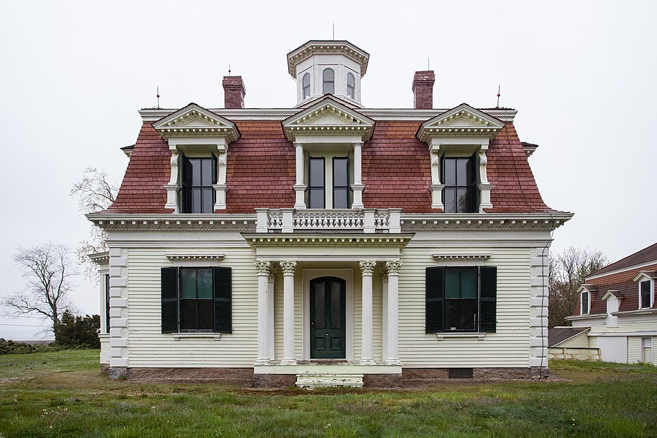
Built in 1868 in the Second Empire architecture in the United States and Canada. Listed on the National Register of Historic Places in
1976. A historic map-sheet match is not published yet. The record needs a coordinate-quality review before it can be joined to a sheet boundary.
From the record
“The Edward Penniman House and Barn is a historic site in Eastham, Massachusetts, on Fort Hill, which is currently protected by the Cape Cod National Seashore and home to Indian Rock.”
Wikipedia article Edward Penniman House and Barn, CC BY-SA 4.0.
one of 145 National Register listings in Barnstable County · listed in 1976 · category: Building · built in 1868, Second Empire architecture in the United States and Canada.
Architectural style. Second Empire architecture in the United States and Canada
National Register reference number.76000155- the number the National Park Service assigned this property when it was listed, and the key its nomination file is catalogued under at the National Archives.
About thirty-five years ago my husband and myself, in company with his brother Freeman Higgins and his wife, went to Orleans and Eastham on Cape Cod, accepting the hospitable invitation of Jonathan Higgins, Esquire, who was then the leading attorney in that section of the State. Mr. Higgins had many valuable old deeds and records pertaining to the history and genealogy of the Higgins family. He and his close friend, Mr. Josiah Paine of Harwich, rendered us great assistance in our search for the early historical records of .this family, which at one time had more representatives in Eastham and Orleans than any other.
The original records of the town of Eastham at that time were kept in a safe at the grocery store at Orleans and we were afforded access to them. The interest aroused at that time has never waned, although a whole generation has passed since its beginning. Our research has extended from Maine to California in our own country. In England we have diligently investigated both personally and through the Rev. Charles H. Pope, author of The Pioneers of Massachusetts. The result of his investigation will be found in this work. Mr. Pope also carefully revised the manuscript several years ago and prepared it for publication. The delay of the publication for several years has made it possible to secure many new records and to verify those already obtained.
Regional context, not property-specific
evidence. The
federal wildfire occurrence database
lists 79 fires within 5 miles of Penniman, Edward, House and Barn between
1993 and 2020, burning about 44 acres in total. 9 started naturally. 2 were recorded as arson.
Distance is straight-line from the map coordinates, so a fire counted
here may appear on a neighbouring settlement's page as well.
Reported cause
Fires
Missing data/not specified/undetermined
30
Equipment and vehicle use
15
Debris and open burning
10
Natural
9
Recreation and ceremony
8
Arson/incendiarism
2
Fireworks
2
Smoking
2
Misuse of fire by a minor
1
The most recent of
them, most recent first, with the day each was reported and the service
that recorded it.
Regional context, not property-specific
evidence. Museums hold 2,763 specimens
collected within 10 miles of Penniman, Edward, House and Barn between 1819 and
1975: 1,361 Animalia, 1,050 Plantae, 180 Fungi, 68 Bacteria, 60 Chromista, 44 Unrecorded. 12 distinct Species records are shown.
Collected by A. B. Seymour, A. R. Alan Hodgdon Hodgdon, A. R. Hodgdon and others. Each is a
physical object with a catalogue
number, and each entry opens the museum's record. This is what was
collected and kept, not a survey of what lives here - nothing can be
concluded from a species being absent.
Regional context, not property-specific
evidence. The federal mineral resources record lists
1 working within 5 miles of Penniman, Edward, House and Barn: 1 past producer.
None of them still produces. What was taken out: Sand and Gravel, Construction. Distance is straight-line from the
map coordinates, so a quarry counted here may appear on a neighbouring
settlement's page as well.
Regional context, not property-specific
evidence. The National Weather Service names
Eastham, the town this property stands in, in 8 storm reports between 2001 and 2018: 4 lightning, 1 hail, 1 storm surge/tide, 1 thunderstorm wind.
The reports record 4 injuries. Each account below is quoted exactly as the forecast office
filed it, from the NOAA Storm Events Database, and each date
opens the federal record of that event.
A 62 year old woman and a 4 year old girl were struck by lightning while getting out of a car. The woman was holding an umbrella for the girl when lightning struck. Both were transported to Cape Cod Hospital for evaluation but were released with no injuries.
At 1138 PM EST, Cable Road near Nauset Regional High School in Eastham was flooded and impassable. At 1154 PM EST, there were multiple reports of flooded basements on Jennie Clark Road. There were also reports of flooded basements on Kingswood Drive and Cestaro Way. At 1204 AM EST a car on Gail's Way was trapped in flood waters in a road washout. At 1252 AM EST there was three feet of water on Old Orchard Road near Kettle Hole Road. At 111 AM EST, two cars were trapped in flood waters on Brackett Road. At 6 AM EST, a Cocorahs observer in Eastham reported a storm total rainfall of 8.25 inches.
No historic map-sheet match is published
for this property yet. That does not mean no map exists. This record needs
a coordinate-quality review before it can be joined to a sheet boundary.
Browse the county's mapped places while that work is
pending.
From the nomination file
2,942 words on record
When this property was proposed for the
National Register, someone wrote the case for it: what the building is,
and why it matters. That document is a federal record in the public domain.
It is quoted below word for word, never summarised. The text was read off the scanned case file by machine, so the
occasional stray character is the recogniser's and the 1970s
typewriter's.
Description of the property
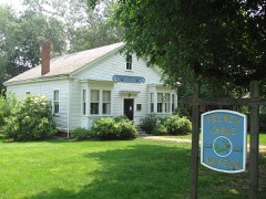
-Ruins - Unexposed (Check One) -Moved [x] Original Site Located on the south side of Fort Hill road near the intersection of Fort Hill Road and Governor Prence Road, and 1/4 mile east of U.S.Mid-Cape Highway 6, the Captain Edward Penniman House is a two and a half story frame house in the Second Empire French style with a matching barn to the rear. The house is rectangular and faces west, and is surrounded by resi- dential planting. The building is painted yellow with white trim and has a red roof, striped.
This was a sumptuous whaling captain's home of 1867, known historically as the "finest house in Eastham." The house has been painted several times, and prior to recent outside restoration, was badly "alligatored." Removal of this old paint revealed colors similar to those used in recent restoration. All dentil work was removed, scraped, repainted and replaced. Over-all dimensions of the house are 40'-5" on the west and 34'-7" on the south. The foundations are of field stone topped with granite. The walls are of frame construction with clapboards on the exterior. The main front door on the west side has a porch with Corinthian columns, fluted shafts and pressed wood capitals. The rear or east door has a plank stoop. The house has two centralized red brick chimneys.
The front door of the house is a heavy wooden door with an arched top and two vertical etched glass panels in the top half. The rear or east door is also heavy, but has a flat top, and one panel of glass. A11 windows on the first floor are the same size and all of the windows on the second floor are the same size with those on the first floor slightly larger.
The art of whaling originated on Cape Cod, and the art and business reached its peak in the mid-19th century. Like most whaling captains, Penniman operated out of New Bedford, being in charge of several vessels during his long lifetime. He chose to retire in Eastham, and built this house in 1867. Penniman undertook whaling voyages to both southern and Arctic latitudes, being absent some 4 years at times. Penniman was born in 1831, one of 11 children. He went to sea at eleven. His fourth whaling voyage took place in 1860 in the Minerva. After retirement, Penniman undertook a business venture in Chicago, lost money, and returned to whaling for a time. On one South Atlantic trip, gone 3 years, he came back with 42000 bbls. of oil, one of the largest hauls ever to port at New Bedford.
His wife, Betsey Knowles Penniman, accompanied her husband on some trips--(his wife was born in the house directly across the street from the Penniman House). His seventh and last voyage was 1881-1884 in the Jacob A. Howland, a three year's voyage to the Arctic. Penniman was a typical whaling captain. Records show that he never lost a vessel in his command. He died in 1913, and his son, Eugene, carried on the work for a short time. . The real significance of the house lies in three factors: The unique appearance of the house (plans were said to have been brought back from France by Penniman, personally), the fact that this is the only whaling captain's house in Eastham, and it is the only one inside the Seashore boundaries.
-Restoration of the interior will depend on public interest and availability of funds. Much victorian furniture (some of it from this house) is stored at the Seashore.
Quoted from the National Register nomination
for reference 76000155, 13 pages, held by the National Archives in Record
Group 79. See the
catalogue record.
Listed places nearby
6 within 8 miles
Other National Register properties close
enough to walk or drive between, ordered by distance from this one. Both
positions come from the same geocoding pass that matched these properties
to their map sheets.
Listing record. National Park Service National Register of Historic Places, listed-properties dataset, current to 2026-05-22.
Map join. Address geocoded through the United States Census geocoder, then tested against the published boundary of every sheet in the USGS Historical Topographic Map Collection.
How this page is made. Listing fields come from federal records; map-sheet coverage is a labelled coordinate-to-boundary calculation, not a source-field claim.
Wildfire. Short, Karen C. 2022. Spatial wildfire occurrence data for the United States, 1992-2020 [FPA_FOD_20221014]. 6th Edition. Fort Collins, CO: Forest Service Research Data Archive. https://doi.org/10.2737/RDS-2013-0009.6 Collected with United States Government funding and usable without additional permissions or fees.
Specimens. Global Biodiversity Information Facility (GBIF), https://www.gbif.org/. Only records licensed CC0 or CC BY are used. Records licensed CC BY-NC are excluded because this site carries advertising. Images are checked individually and any whose licence is non-commercial, no-derivatives or unreadable is refused.
Mines and quarries. USGS Mineral Resources Data System (MRDS) https://mrdata.usgs.gov/mrds/ A work of the United States government, no copyright under 17 U.S.C. 105.
Storms. NOAA National Centers for Environmental Information, Storm Events Database https://www.ncei.noaa.gov/stormevents/ A work of the United States government, no copyright under 17 U.S.C. 105. Narratives are quoted verbatim from the National Weather Service report and are not edited or summarised.
 Block
Block