Listed on the National Register of Historic Places in
1977. A historic map-sheet match is not published yet. The record needs a coordinate-quality review before it can be joined to a sheet boundary.
From the record
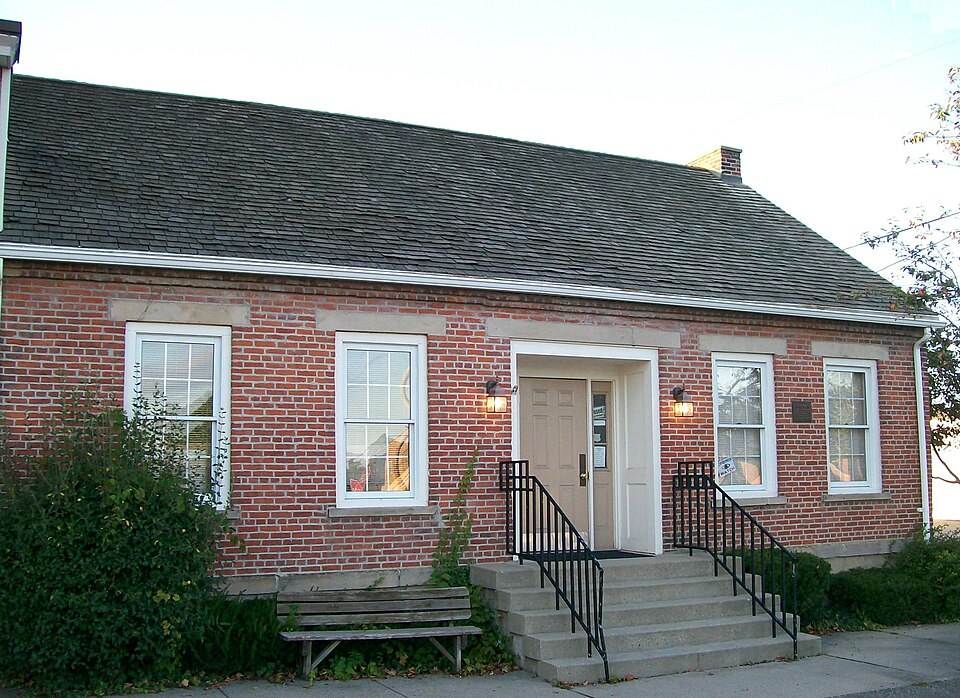
“The John Reaves House is a historic residence and government building in the village of Freeport, Ohio, United States. Constructed by one of the area's earliest settlers, it was later home to one of Freeport's most significant citizens.”
Wikipedia article John Reaves House, CC BY-SA 4.0.
one of 5 National Register listings in Harrison County · listed in 1977 · category: Building.
National Register reference number.77001068- the number the National Park Service assigned this property when it was listed, and the key its nomination file is catalogued under at the National Archives.
VI. Thompson. VII. John-Thornton, b. in Virginia, February 11, 1802; removed about 1834 from Belmont county to Harrison county, and settled four miles from Freeport, in Freeport township, Harrison county, where he d. March 1, 1877; m. September 14, 1824, Mary Jackson Billingsby, a native of Virginia; d. August 15, 1870; had issue: 1. Lorinda; 2. Vitura; 3. Celestine; 4. Melinda; 5. Ruth; 6. George-W., b. February 21, 1833, in Belmont county; removed to Harrison county with his parents; settled in Freeport, Harrison county. VIII. Elizabeth. ^
America about 1812 and settled in Freeport township, Harrison county, Ohio; had issue: 1. Samuel; 2. William, b. 1798; d. April 12, 1867; m. about 1864, Anne White, b. in Ireland', 1802; d. at Freeport, Jan. 7, 1879 (had issue: i. John, m. Sarah Fulton; ii. Hannah, m. William Williams; iii. George, b. 1827; m. Eliza Vail Markee, daughter of William and Hannah Norris Vail; iv. Sarah, d. young; v. Eliza, m. William Fulton: vi. Mary, m. James Fulton; vii.
Regional context, not property-specific
evidence. The
federal wildfire occurrence database
lists 7 fires within 5 miles of Reaves, John, House between
2003 and 2015, burning about 11 acres in total. None started naturally. None was recorded as arson.
Distance is straight-line from the map coordinates, so a fire counted
here may appear on a neighbouring settlement's page as well.
Reported cause
Fires
Missing data/not specified/undetermined
3
Debris and open burning
3
Equipment and vehicle use
1
The most recent of
them, most recent first, with the day each was reported and the service
that recorded it.
Regional context, not property-specific
evidence. Museums hold 102 specimens
collected within 10 miles of Reaves, John, House between 1929 and
1967: 53 Animalia, 42 Plantae, 7 Fungi. 12 distinct Species records are shown.
Collected by Adams J. M. R., Adams J. R. M., Buker, W.E. and others. Each is a
physical object with a catalogue
number, and each entry opens the museum's record. This is what was
collected and kept, not a survey of what lives here - nothing can be
concluded from a species being absent.
Regional context, not property-specific
evidence. The National Weather Service names
Freeport, the town this property stands in, in 15 storm reports between 2002 and 2025: 13 thunderstorm wind, 2 flash flood.
No death or injury is recorded in these reports. Each account below is quoted exactly as the forecast office
filed it, from the NOAA Storm Events Database, and each date
opens the federal record of that event.
No historic map-sheet match is published
for this property yet. That does not mean no map exists. This record needs
a coordinate-quality review before it can be joined to a sheet boundary.
Browse the county's mapped places while that work is
pending.
From the nomination file
1,176 words on record
When this property was proposed for the
National Register, someone wrote the case for it: what the building is,
and why it matters. That document is a federal record in the public domain.
It is quoted below word for word, never summarised. The text was read off the scanned case file by machine, so the
occasional stray character is the recogniser's and the 1970s
typewriter's.
Description of the property
6/6 light windows. These have plain stone lug sills and stone lintels. The west end of the house has a centered paneled door. To either side of the doorway are 6/6 light windows identical to those of the facade. To either side of the flush, interior chimney there is a smaller 6/6 windows. All windows have stone lintels and sills. CONDITION remodeled. DATE EXCELLENT UNALTERED DESCRIPTION RUINS pane window.
FAIR CHECK ONE UNEXPOSED smooth stone blocks with two courses exposed above grade.There isa have three panes over a molded panel.A multi-paned transom is The rear of the building is divided into five equal bays.The second The west side of the building is attached toa one-story frame church This simple brick house is 1-1/2 stories in height.The foundation is smooth stone water table.The facade (south) features a handsome The gable roof is standing seam metal. _MOVED above the door and sidelights.To either side of the doorway are two structure.This building dates from about 1880,but has been extensively AREAS OF
Statement of significance
The John Reaves house is the oldest house in Freeport and was the home of one of its most important citizens. In 1888 one room of the house was quite handsome, especially its south entrance and is unquestionably the The house was built prior to 1820 by Daniel Easley who had migrated from Virginia about 1804. Mr. Easley sold the house to the Reaves family River and to Illinois where he founded Freeport, Illinois. John Reaves was one of Freeport's first teachers. He was the first Freeport citizen to enlist in the Civil War and the first in Harrison County to lose In 1884 while the house was still owned by the Reaves family, Israel J. village's first telephone office.
When the last member of the Reaves family died, more than 20 years ago, a family named Clark purchased the property and saved it from destruction. They added water, electricity, and a bathroom. They have recently donated the 1500-1599 1400-1499 LAW X1800-1899 ECONOMICS ART ARCHEOLOGY-HISTORIC AGRICULTURE PERIOD INDUSTRY COMMUNICATIONS RELIGION SIGNIFICANCE BUILDER/ARCHITECT ARCHEOLOGY-PREHISTORIC MUSIC LITERATURE MILITARY SCULPTURE library. _POLITICS/GOVERNMENT INVENTION _EXPLORATION/SETTLEMENT _PHILOSOPHY _ENGINEERING _SOCIAL/HUMANITARIAN _TRANSPORTATION _CONSERVATION _EDUCATION _PREHISTORIC -1600-1699 _THEATER his life.in the war. - 1700-1799 -1900- used as the first bank of Freeport. Architecturally the building is best building remaining in Freeport.
building to the town for use as a combined village hall, museum, and X OTHER (SPECIFY) and then he departed by flat boat on the Stillwater Creek to the Ohio
Quoted from the National Register nomination
for reference 77001068, 10 pages, held by the National Archives in Record
Group 79. See the
catalogue record.
Listing record. National Park Service National Register of Historic Places, listed-properties dataset, current to 2026-05-22.
Map join. Address geocoded through the United States Census geocoder, then tested against the published boundary of every sheet in the USGS Historical Topographic Map Collection.
How this page is made. Listing fields come from federal records; map-sheet coverage is a labelled coordinate-to-boundary calculation, not a source-field claim.
Wildfire. Short, Karen C. 2022. Spatial wildfire occurrence data for the United States, 1992-2020 [FPA_FOD_20221014]. 6th Edition. Fort Collins, CO: Forest Service Research Data Archive. https://doi.org/10.2737/RDS-2013-0009.6 Collected with United States Government funding and usable without additional permissions or fees.
Specimens. Global Biodiversity Information Facility (GBIF), https://www.gbif.org/. Only records licensed CC0 or CC BY are used. Records licensed CC BY-NC are excluded because this site carries advertising. Images are checked individually and any whose licence is non-commercial, no-derivatives or unreadable is refused.
Storms. NOAA National Centers for Environmental Information, Storm Events Database https://www.ncei.noaa.gov/stormevents/ A work of the United States government, no copyright under 17 U.S.C. 105. Narratives are quoted verbatim from the National Weather Service report and are not edited or summarised.
 Block
Block