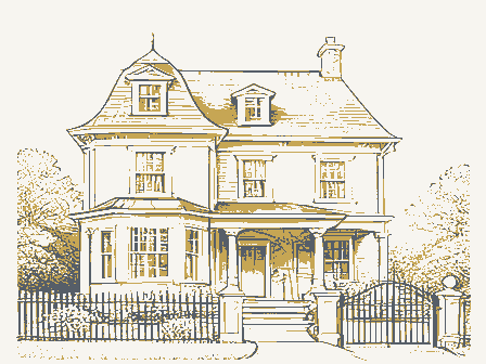
Listed on the National Register of Historic Places in
1978. A historic map-sheet match is not published yet. The record needs a coordinate-quality review before it can be joined to a sheet boundary.
From the record
one of 338 National Register listings in Cuyahoga County · listed in 1978 · category: Building · one of 3 National Historic Landmarks in Cuyahoga County.
National Register reference number.78002037- the number the National Park Service assigned this property when it was listed, and the key its nomination file is catalogued under at the National Archives.
Specimens collected near this property
12 of 1,673 shown
Regional context, not property-specific
evidence. Museums hold 1,673 specimens
collected within 10 miles of March, George, House between 1893 and
1975: 1,601 Animalia, 38 Plantae, 29 Fungi, 3 Protozoa, 1 incertae sedis, 1 Unrecorded. 12 distinct Species records are shown.
Collected by A. Woolman, AUSLEY, G, Adams and others. Each is a
physical object with a catalogue
number, and each entry opens the museum's record. This is what was
collected and kept, not a survey of what lives here - nothing can be
concluded from a species being absent.
Regional context, not property-specific
evidence. The federal mineral resources record lists
1 working within 5 miles of March, George, House: 1 unknown.
None of them still produces. What was taken out: Zirconium. Distance is straight-line from the
map coordinates, so a quarry counted here may appear on a neighbouring
settlement's page as well.
Regional context, not property-specific
evidence. The National Weather Service names
Chagrin Falls, the town this property stands in, in 12 storm reports between 1995 and 2023: 7 thunderstorm wind, 4 flash flood, 1 hail.
No death or injury is recorded in these reports. Each account below is quoted exactly as the forecast office
filed it, from the NOAA Storm Events Database, and each date
opens the federal record of that event.
Heavy rainfall of 1.5 to almost 3 inches fell between 1 and 4 pm causing flash flooding in Chagrin Falls. Water was flowing from upstream in Geauga County to the Chagrin Falls area and residents reported a 6-foot wall of water moved through the neighborhood and destroyed the wall of a walk out basement on Elm Court. Numerous other basements in the area were flooded. Several roads had to be closed due to the flooding. Rapid rises occurred on the Chagrin River with the water running swiftly and at high capacity.
No historic map-sheet match is published
for this property yet. That does not mean no map exists. This record needs
a coordinate-quality review before it can be joined to a sheet boundary.
Browse the county's mapped places while that work is
pending.
From the nomination file
1,854 words on record
When this property was proposed for the
National Register, someone wrote the case for it: what the building is,
and why it matters. That document is a federal record in the public domain.
It is quoted below word for word, never summarised. The text was read off the scanned case file by machine, so the
occasional stray character is the recogniser's and the 1970s
typewriter's.
Description of the property
two doors, leading into separate rooms, joined by a paneled surround and narrow overharing cornice molding forming a long lintel. To either side of the doorway are 6/6 light windows with plain linteled sills & wood shutters. the porch, one from the main house and one at right angles to it in The remaining portion of the addition has a single window, centrally front of the house, and of four small bedrooms on the rear. These original hardware, molding and floors are intact. CONDITION UNEXPOSED DETERIORATED EXCELLENT RUINS FAIR CHECK ONE placed on the north side.The wide cornice and corner pilasters the corner of the addition.Windows are 6/6 with plain surrounds.
behind a proch which features square pillars.Two doorways open onto A one-story wing extends to the east.A three-bay section is recessed of a central chimney and fireplaces for the main front rooms. the east gable end has been added for an upstairs bathroom. Interior alterations were made prior to 1940.Most of the addition both have centrally placed chimneys.A small window on The 1-1/2 story frame house is gable roofed.The ridgelinwruns latter have been removed to allow a living room to extend the entire of the main section are also employed in the addition.which dates -UNALTERED boards with returns at the gable ends.The facade hasa X-GOOD depth of the house. The cellar retains a chimney base, evidence parallel to the street.There are wide corner pilasters and cornice AREAS OF
Statement of significance
The house was the main farmhouse on the property of George March, in the development of the region, actively recruiting settlers from The town of Chagrin Falls was founded in 1833 by Noah Graves, a native By the end of the summer of 1833 a dam across the river had including George March, arrived. 1500-1599 1400-1499 INVENTION ART ARCHEOLOGY-HISTORIC EDUCATION POLITICS/GOVERNMENT LAW AGRICULTURE PERIOD INDUSTRY RELIGION ARCHEOLOGY-PREHISTORIC BUILDER/ARCHITECT SIGNIFICANCE TRANSPORTATION ARCHITECTURE THEATER SCIENCE MILITARY COMMERCE MUSIC -1600-1699 Chagrin Falls area.He was a well-to-do farmer who was instrumental locally believed to be the oldest remaining building in the village.
to Chagrin Falls from Massachusetts in 1833 and began farming the land been built and a saw mill was in operation.Several new settlers, _PREHISTORIC the commercial center of the town, was purchased by Graves from The house lot is the only vestige of a farm which orignally totalled one Capt.Edward Paine of Chardon.The 210 acres were purchased for important locally as a reminder of the towns early settlement. _CONSERVATION LITERATURE _ECONOMICS -1700-1799 hundred forty acres.March was one of the earliestsettlers of the -SCULPTURE -1900- important early settler and promoter of Chagrin Falls and as such is SPECIFIC DATES 1837, 1840 of Sunderland, Massachusetts.
The land, encompassing what is now EXPLORATION/SETTLEMENT the region near his home in Worcester, Massachusetts.March migrated where the house stands.The house itself was built in 1837.It is
Quoted from the National Register nomination
for reference 78002037, 12 pages, held by the National Archives in Record
Group 79. See the
catalogue record.
Listed places nearby
6 within 8 miles
Other National Register properties close
enough to walk or drive between, ordered by distance from this one. Both
positions come from the same geocoding pass that matched these properties
to their map sheets.
Listing record. National Park Service National Register of Historic Places, listed-properties dataset, current to 2026-05-22.
Map join. Address geocoded through the United States Census geocoder, then tested against the published boundary of every sheet in the USGS Historical Topographic Map Collection.
How this page is made. Listing fields come from federal records; map-sheet coverage is a labelled coordinate-to-boundary calculation, not a source-field claim.
Specimens. Global Biodiversity Information Facility (GBIF), https://www.gbif.org/. Only records licensed CC0 or CC BY are used. Records licensed CC BY-NC are excluded because this site carries advertising. Images are checked individually and any whose licence is non-commercial, no-derivatives or unreadable is refused.
Mines and quarries. USGS Mineral Resources Data System (MRDS) https://mrdata.usgs.gov/mrds/ A work of the United States government, no copyright under 17 U.S.C. 105.
Storms. NOAA National Centers for Environmental Information, Storm Events Database https://www.ncei.noaa.gov/stormevents/ A work of the United States government, no copyright under 17 U.S.C. 105. Narratives are quoted verbatim from the National Weather Service report and are not edited or summarised.
 Block
Block