Photograph by Roseohioresident, Public domain. Via
Wikimedia Commons.
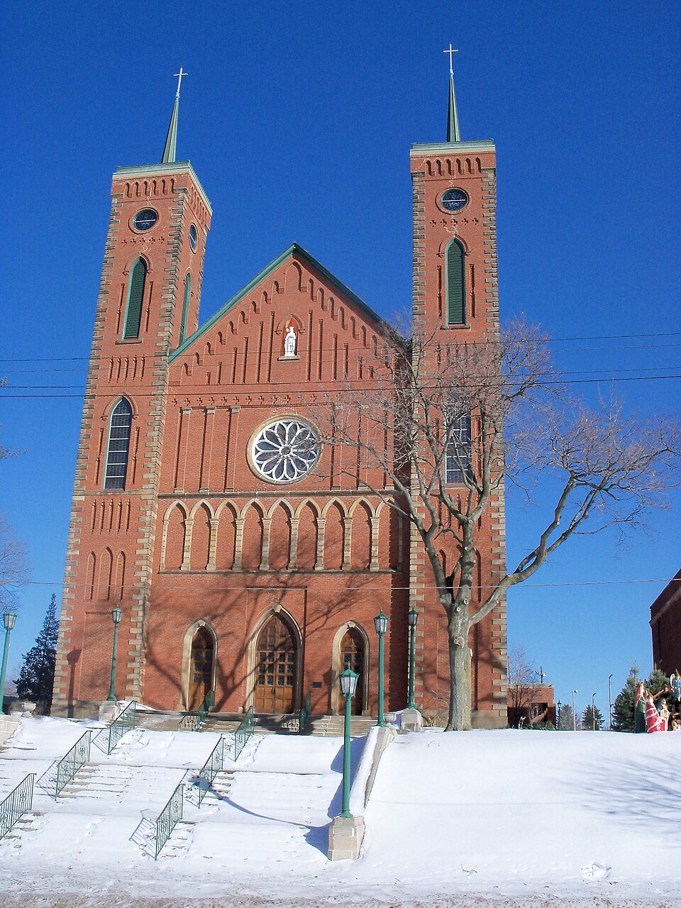
St. Louis Church
Listed on the National Register of Historic Places in
1979. A historic map-sheet match is not published yet. The record needs a coordinate-quality review before it can be joined to a sheet boundary.
From the record
“Louis Church is a historic Roman Catholic church in Louisville, Ohio. The building was added to the National Register of Historic Places in 1979.”
Wikipedia article St. Louis Church (Louisville, Ohio), CC BY-SA 4.0.
one of 81 National Register listings in Stark County · listed in 1979 · category: Building.
National Register reference number.79001951- the number the National Park Service assigned this property when it was listed, and the key its nomination file is catalogued under at the National Archives.
Tho name ia of Indian origin, and probably commemorative of peculiarities of lands. Tbo depot of tho Pittsburg, Fort Wayne and Chicago Railroad, which traverses tho township, is built on the site of Loutzonheiser'a house. The old township records were destroyed, - an irretrievable loss. From Adam Lout- Ecnhoifcr, resident of Louisville since January 30, 1308, and the first born white in the township, we glean these fragments of its history.
John Warner and brothers made a scttlemoDt in the northwest comer of tho township in 1807, and found good level agricultural lauds. John Eby, nn 1807 settler, put up a saw- and grist-mill on the Nimiahillcn, a mile and a half west of Louisville, in 1310, the first of the kind erected. The first sleom saw-mill was put up and run by Henry Hoover, on tho east lino of tho township. Its career wna brief; soon exploding, it killed John Reed, tho fireman. Henry Leah was killed at a raising by tho falling of a log, - the first death by accident in tho township.
Regional context, not property-specific
evidence. The
federal wildfire occurrence database
lists 1 fire within 5 miles of St. Louis Church between
2005 and 2005, burning about 30 acres in total. None started naturally. None was recorded as arson.
Distance is straight-line from the map coordinates, so a fire counted
here may appear on a neighbouring settlement's page as well.
Reported cause
Fires
Debris and open burning
1
The most recent of
them, most recent first, with the day each was reported and the service
that recorded it.
Regional context, not property-specific
evidence. Museums hold 246 specimens
collected within 10 miles of St. Louis Church between 1836 and
1975: 194 Animalia, 41 Plantae, 7 Fungi, 4 Unrecorded. 12 distinct Species records are shown.
Collected by Anson A. Hinkley, Antonio, T., Armbruster, D. C. (Daniel C.) and others. Each is a
physical object with a catalogue
number, and each entry opens the museum's record. This is what was
collected and kept, not a survey of what lives here - nothing can be
concluded from a species being absent.
Regional context, not property-specific
evidence. The federal mineral resources record lists
8 workings within 5 miles of St. Louis Church: 6 past producers, 2 producers.
2 still produce. What was taken out: Sand and Gravel, Construction, Clay, Stone, Crushed/Broken. Distance is straight-line from the
map coordinates, so a quarry counted here may appear on a neighbouring
settlement's page as well.
Regional context, not property-specific
evidence. The National Weather Service names
Louisville, the town this property stands in, in 24 storm reports between 1996 and 2025: 13 hail, 6 thunderstorm wind, 4 flash flood, 1 lightning.
No death or injury is recorded in these reports. Each account below is quoted exactly as the forecast office
filed it, from the NOAA Storm Events Database, and each date
opens the federal record of that event.
A thunderstorm with heavy rainfall moved over northeast Stark County between 730 and 830 pm. The storms forward motion slowed and it remained nearly stationary during the hour. The storm produced rainfall rates estimated at 3 inches per hour though no official rain gauges were available in the immediate vicinity of the storm. The storms heaviest rain fell over Louisville between N Chapel Street (Route 44) and Hwy 62. An apartment complex near Reno Drive sustained flood damage to 27 cars with some water into the lower level apartments. A small tributary to the East Branch of the Nimishillen Creek near Reno Drive came out of banks and damaged a bridge. Another apartment complex on Constitution Avenue was flooded resulting in water rescues around 845 pm through 930 pm. Four units flooded with up to 4 inches of water. Flood waters inundated the property of a few businesses on Constitution Avenue but did not inundate any of the buildings. The Main Street intersection in town was flooded at Constitution Avenue. The river gauge provided by the USGS measured a stage of 13.62 feet around 1120 PM in Louisville off of Constitution Avenue.
A thunderstorm with heavy rain, peaking at an estimated 5 inches per hour around 7 PM with an estimated storm total rainfall around 1.75 inches in 30 minutes. The East Branch of the Nimishillen Creek came out of banks cresting at 13.11 feet in Louisville at moderate flood stage. Flooded roads include Main Street and Frana Clara. The Fire Chief reported water was inches from getting into the Gazebo apartments on Constitution Ave and it cut off access and flooded cars in the parking areas around the buildings.
ODOT reported OH 44 closed between Easton Street and US 62 due to downed power lines about two miles north of Louisville. Spotter reported numerous tree branches snapped and six telephone poles downed in same area. Time estimated via radar.
Widespread flooding across Stark County. Flash flooding with rushing water over roads in Louisville, Hartville, Jackson Township, and North Canton. Numerous roads closed. SR 241 between Shuffel road and Strausser road is closed due 2 feet of water over the road. Price Park flooded in North Canton. A rain gage reported 2.17 inches in 30 minutes in Jackson Township.
No historic map-sheet match is published
for this property yet. That does not mean no map exists. This record needs
a coordinate-quality review before it can be joined to a sheet boundary.
Browse the county's mapped places while that work is
pending.
From the nomination file
1,979 words on record
When this property was proposed for the
National Register, someone wrote the case for it: what the building is,
and why it matters. That document is a federal record in the public domain.
It is quoted below word for word, never summarised. The text was read off the scanned case file by machine, so the
occasional stray character is the recogniser's and the 1970s
typewriter's.
Description of the property
wide and 130 feet long. The corners of the facade are dominated by 100 foot arches in the form of blind arches, stain glass windows, and louvered windows. The main gothic arched entrance is in the center of the facade. Doors were a white marble statue of the patron Saint, St. Louis, added to the formerly blind slate, but now has green tiles. are 125 foot tree trunks, are formed of what appears to be clusters of slender The pine pews, which are original, have delicate scrollwork and pointed arches on was cut down, the original hand carved pulpit removed, and floors tiled. The light- During the 1950s and 60s, new stained glass windows were added and the exterior CONDITION UNEXPOSED DETERIORATED EXCELLENT XGOOD FAIR UNALTERED the walnut arm rests.
CHECK ONE XALTERED poles and have plastercast capitals with naturalistic forms. supported by the gothic arch corbeling. The interior follows the traditional church pattern with a central nave flanked by ing fixtures were installed in the l940s and murals painted in the sanctuary. circular rose window with tracery.The gable has a gothic arched niche containing secondary doors flank the main entrance. large circle openings for the belfry. They are topped by gothic arch corbeling was cleaned and repointed. St.Louis Church is a rectangular brick building on a stone foundation 6o feet A significant number of alterations have been made on the interior since l904.In and slender copper spires.The latter were added in the 1950s.
There are two blind arcades on the facade,.one with gothic arches, and the other _RUINS The towers also have false loopholes reminiscent of medieval arrow loops and There are stone and brick buttresses on the side elevation separating the large AREAS OF
Statement of significance
law-abiding, honest, pay their debts, and make good neighbors." The church was designed by the priest of the parish at the time, Father Louis Hoffer. was designed by a Cleveland architect, Frank Walsh. many of the materials for the building from their surrounding farms, and also helped provide some labor. The construction, completed in 1875, was also supervised by 1400-1499 1700-1799 1870-75 Louisville. LAW ART ARCHEOLOGY-HISTORIC PERIOD CONSERVATION POLITICS/GOVERNMENT TRANSPORTATION X1800-1899 SCULPTURE AGRICULTURE BUILDER/ARCHITECT Father Hoffer. SIGNIFICANCE LITERATURE present church. The interior has undergone some significant changes since its construction, but the PREHISTORIC INDUSTRY architectural monument and an important link to the French heritage of Louisville.
A congregation was soon established and materials began to be allocated for a brick _EXPLORATION/SETTLEMENT about their new home and prompted a large-scale French immigration to the Louis- exterior essentially retains its 1875 appearance.It remains today as an imposing Stark County, was finally selected because a newly established Catholic parish He supposedly patterned it after a small village cathedral in France.The interior _COMMUNICATIONS The St.Louis Church is an excellent example of the High Victorian Gothic style of architecture and the most notable manifestation of the French heritage of Father Louis Hoffer that these Frenchmen were to Construction of the church began in l87o.The members of the congregation supplied -1600-1699 -1500-1599 -EDUCATION - ENGINEERING - ECONOMICS -MILITARY -1900- too large for the original structure and it was razed in 1869 to make way for the -THEATER -MUSIC _COMMUNITY PLANNING A small group of Catholic families left eastern France in 1826 and emigrated to villk area.
By 1881 the county history related that there were "several hundred ARCHEOLOGY-PREHISTORIC INVENTION the surrounding countryside to locate a settlement site.
Quoted from the National Register nomination
for reference 79001951, 19 pages, held by the National Archives in Record
Group 79. See the
catalogue record.
Listed places nearby
6 within 8 miles
Other National Register properties close
enough to walk or drive between, ordered by distance from this one. Both
positions come from the same geocoding pass that matched these properties
to their map sheets.
Listing record. National Park Service National Register of Historic Places, listed-properties dataset, current to 2026-05-22.
Map join. Address geocoded through the United States Census geocoder, then tested against the published boundary of every sheet in the USGS Historical Topographic Map Collection.
How this page is made. Listing fields come from federal records; map-sheet coverage is a labelled coordinate-to-boundary calculation, not a source-field claim.
Wildfire. Short, Karen C. 2022. Spatial wildfire occurrence data for the United States, 1992-2020 [FPA_FOD_20221014]. 6th Edition. Fort Collins, CO: Forest Service Research Data Archive. https://doi.org/10.2737/RDS-2013-0009.6 Collected with United States Government funding and usable without additional permissions or fees.
Specimens. Global Biodiversity Information Facility (GBIF), https://www.gbif.org/. Only records licensed CC0 or CC BY are used. Records licensed CC BY-NC are excluded because this site carries advertising. Images are checked individually and any whose licence is non-commercial, no-derivatives or unreadable is refused.
Mines and quarries. USGS Mineral Resources Data System (MRDS) https://mrdata.usgs.gov/mrds/ A work of the United States government, no copyright under 17 U.S.C. 105.
Storms. NOAA National Centers for Environmental Information, Storm Events Database https://www.ncei.noaa.gov/stormevents/ A work of the United States government, no copyright under 17 U.S.C. 105. Narratives are quoted verbatim from the National Weather Service report and are not edited or summarised.
 Block
Block