Listed on the National Register of Historic Places in
1980. A historic map-sheet match is not published yet. The record needs a coordinate-quality review before it can be joined to a sheet boundary.
From the record
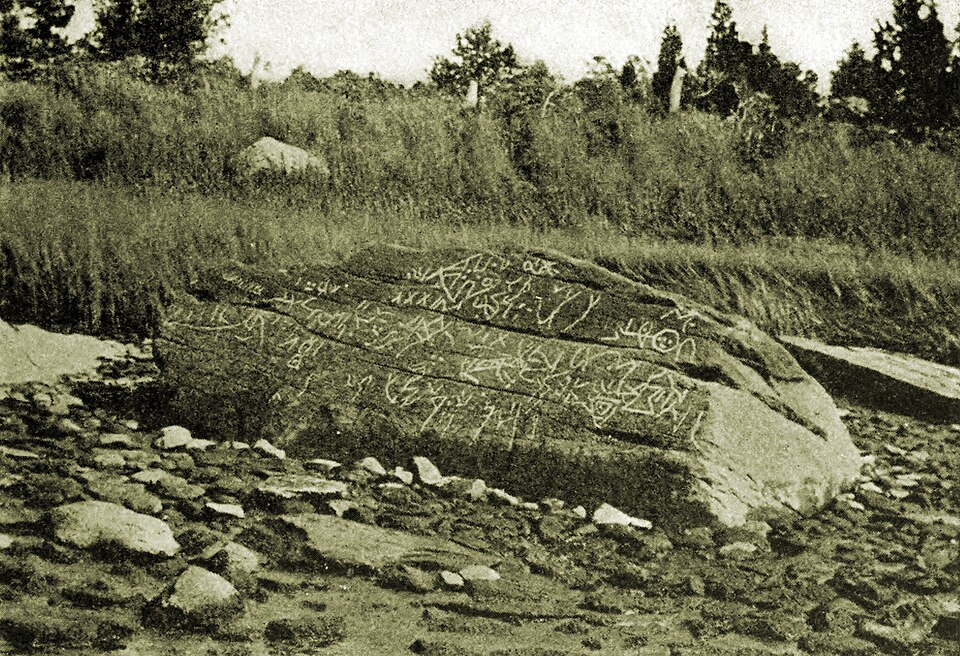
“The Dighton Rock is a 40-ton boulder composed of sandstone, originally located in the riverbed of the Taunton River at Berkley, Massachusetts, formerly part of the town of Dighton. The rock is noted for its petroglyphs, "primarily lines, geometric shapes, and schematic drawings of people, along with writing, both verified and not".”
Wikipedia article Dighton Rock, CC BY-SA 4.0.
one of 272 National Register listings in Bristol County · listed in 1980 · category: Object · one of 8 National Historic Landmarks in Bristol County.
National Register reference number.80000438- the number the National Park Service assigned this property when it was listed, and the key its nomination file is catalogued under at the National Archives.
From this celebrated man, preacher, writer, scholar, philanthropist, and metaphysician the town of Berkley undoubtedly derived its name, for tradition says, "In 1735, when certain inhabitants, living in the southerly part of Taunton and the northerly part of the South Precinct, or Purchase, then Dighton, asked the Great and General Court, for reasons set forth in their petition, for an act of incorporation as a new township," the name of Berkeley was suggested by some one who had probably formed an acquaintance with George Berkeley, then late Bishop of Cloyne, who just before that time had resided at Newport, R. I.
Subsequently it was bought by six proprietors, namely, George Shove, Walter Dean, James Walker, James Tisdale, William Harvey, and Richard Williams. It became a part of Dighton at its organization in 1712, and the town of Berkley in 1752 voted " to grant the request of a number of the inhabitants of Assonet Neck to be inhabitants of the town of Berkley," but it does not appear that any legislative sanction was applied for at that time. In 1798 the following petition was presented to the town of Berkley, and the request granted :
Regional context, not property-specific
evidence. The
federal wildfire occurrence database
lists 41 fires within 5 miles of Dighton Rock between
2015 and 2020, burning about 37 acres in total. None started naturally. 3 were recorded as arson.
Distance is straight-line from the map coordinates, so a fire counted
here may appear on a neighbouring settlement's page as well.
Reported cause
Fires
Missing data/not specified/undetermined
23
Debris and open burning
10
Arson/incendiarism
3
Recreation and ceremony
3
Misuse of fire by a minor
2
The most recent of
them, most recent first, with the day each was reported and the service
that recorded it.
Regional context, not property-specific
evidence. Museums hold 1,212 specimens
collected within 10 miles of Dighton Rock between 1850 and
1975: 869 Animalia, 255 Plantae, 76 Fungi, 9 Chromista, 3 Unrecorded. 12 distinct Species records are shown.
Collected by ?, A E Schuyler, A. C. Birch and others. Each is a
physical object with a catalogue
number, and each entry opens the museum's record. This is what was
collected and kept, not a survey of what lives here - nothing can be
concluded from a species being absent.
Regional context, not property-specific
evidence. The federal mineral resources record lists
9 workings within 5 miles of Dighton Rock: 4 past producers, 4 producers, 1 unknown.
4 still produce. What was taken out: Sand and Gravel, Construction. Distance is straight-line from the
map coordinates, so a quarry counted here may appear on a neighbouring
settlement's page as well.
Regional context, not property-specific
evidence. The National Weather Service names
Dighton, the town this property stands in, in 10 storm reports between 2002 and 2019: 6 thunderstorm wind, 3 hail, 1 lightning.
No death or injury is recorded in these reports. Each account below is quoted exactly as the forecast office
filed it, from the NOAA Storm Events Database, and each date
opens the federal record of that event.
No historic map-sheet match is published
for this property yet. That does not mean no map exists. This record needs
a coordinate-quality review before it can be joined to a sheet boundary.
Browse the county's mapped places while that work is
pending.
From the nomination file
7,932 words on record
When this property was proposed for the
National Register, someone wrote the case for it: what the building is,
and why it matters. That document is a federal record in the public domain.
It is quoted below word for word, never summarised. The text was read off the scanned case file by machine, so the
occasional stray character is the recogniser's and the 1970s
typewriter's.
Description of the property
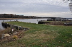
X Moved Ruins - Unexposed (Check One) - Origiral Site Dighton Rock is located in a state park in Berkley, Massachusetts, on the banks of the Taunton River. The Rock is gray, feldspathic boulder weighing approximately 50 tons. The exposed surface of the Rock has dimensions of 10 x 10 x 5 feet. One face of the rock has a broad, smooth, sloping surface on which numerous cryptic inscriptions and symbols have been carved. Formerly the boulder was in the tidal waters of the Taunton River where the inscriptions suttered increasing water damage. In 1964, the Massachusetts Depart- ment of Natural Resources raised the stone to its present level and constructed a landfill under it, forming a promontory.
The Rock is now reddening through chemical reaction with certain iron compounds in the air and is in danger of drying out and crumbling. The Department of Natural Resources proposes to stop these weathering eacion gith processes by erecting a building over Dighton Rock to serve as a protective shelter and also as a tourist center interpreting the Rock's history. 190:: 3000J RECEIVED APR 12 1971 NATIONAL REGISTER CT300:1
Statement of significance
The origin of the petroglyphs on the surface of Dighton Rock is one of America's historic mysteries. These pecked incisions on the feldspathic boulder are apparently a combination of alphabetic and pictorial symbols. Rev. John Davenport first copied the figures in 1680 and interested Cotton Mather in their study. In 1690, Mather described the Rock " filled with strange characters which would suggest as odd thoughts about them... as there are odd shapes in that elaborate monument... ." More than 600 books and articles on Dighton Rock have appeared since Mather first wrote, advancing some 35 theories as to the source of the inscriptions.
Various theories ascribe the petroglyphs to natural weathering, to Viking explorers, to pirates and to the Japanese, Chinese, Phoenicians, Scythians, Egyptians, Romans, Hebrews, and local Indian tribes. The explanation of the Rock currently most popular is that given by the late Professor E. B. Delabarre. Professor Delabarre was convinced that the inscriptions were the Latin record of a visit made to the Rock by the lost Portuguese explorer Miguel Corte-Real. Corte-Real's ship disappeared off the coast of Newfoundland in 1502. Delabarre believed he had found in the inscriptions Corte-Real's name, a Portuguese cross and a date--1511. A local Indian legend also tells of strange men in a wooden house who came up the river and fought with the natives.
Despite wide acceptance of this explanation, however, other of the theories persist and it now seems unlikely that there will ever be definitive evidence in support of any one of them. * Danforth (Edwin w.Small reporte, 10/18/52, NSHSB files) RECENED APk 12 1971 NATIONAL ,REGISTER
Quoted from the National Register nomination
for reference 80000438, 38 pages, held by the National Archives in Record
Group 79. See the
catalogue record.
Listed places nearby
6 within 8 miles
Other National Register properties close
enough to walk or drive between, ordered by distance from this one. Both
positions come from the same geocoding pass that matched these properties
to their map sheets.
Listing record. National Park Service National Register of Historic Places, listed-properties dataset, current to 2026-05-22.
Map join. Address geocoded through the United States Census geocoder, then tested against the published boundary of every sheet in the USGS Historical Topographic Map Collection.
How this page is made. Listing fields come from federal records; map-sheet coverage is a labelled coordinate-to-boundary calculation, not a source-field claim.
Wildfire. Short, Karen C. 2022. Spatial wildfire occurrence data for the United States, 1992-2020 [FPA_FOD_20221014]. 6th Edition. Fort Collins, CO: Forest Service Research Data Archive. https://doi.org/10.2737/RDS-2013-0009.6 Collected with United States Government funding and usable without additional permissions or fees.
Specimens. Global Biodiversity Information Facility (GBIF), https://www.gbif.org/. Only records licensed CC0 or CC BY are used. Records licensed CC BY-NC are excluded because this site carries advertising. Images are checked individually and any whose licence is non-commercial, no-derivatives or unreadable is refused.
Mines and quarries. USGS Mineral Resources Data System (MRDS) https://mrdata.usgs.gov/mrds/ A work of the United States government, no copyright under 17 U.S.C. 105.
Storms. NOAA National Centers for Environmental Information, Storm Events Database https://www.ncei.noaa.gov/stormevents/ A work of the United States government, no copyright under 17 U.S.C. 105. Narratives are quoted verbatim from the National Weather Service report and are not edited or summarised.
 Block
Block