BlockBefore
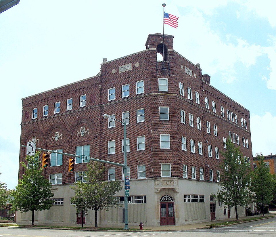
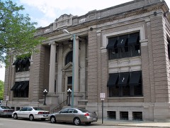
Photograph of Eagles Temple
Photograph by Sanfranman59, CC BY-SA 3.0. Via Wikimedia Commons.

Eagles' Temple

Listed on the National Register of Historic Places in 1982. A historic map-sheet match is not published yet. The record needs a coordinate-quality review before it can be joined to a sheet boundary.

From the record

“The Eagles Temple or Eagles' Temple in Canton, Ohio is a Spanish Colonial Revival building designed during 1927-28. It was listed on the National Register of Historic Places in 1982.”

Wikipedia article Eagles Temple (Canton, Ohio), CC BY-SA 4.0.

one of 81 National Register listings in Stark County · listed in 1982 · category: Building.

Sources: the Wikipedia article · the case file at the National Archives · the National Register database, National Park Service · the Wikipedia article

The listing

  • What is counted as historic. The nomination lists 1 building as contributing to the listing.
  • Address. 601 S. Market St., Canton, 44702
  • When was it listed? 1982-07-15
  • Category. building
  • Township. Canton city
  • National Register reference number. 82003646 - the number the National Park Service assigned this property when it was listed, and the key its nomination file is catalogued under at the National Archives.

The ground it stands on

968,817 words

The chapter on Canton Township in Combination Atlas Map of Stark County, Ohio, Compiled, Drawn and Published from Personal Examinations and Surveys, published 1875 names Canton. This is what it says, exactly as the scans read.

Tho original plal, as recorded in tho clerk's office in Columbiana County, to which tbe territory then belonged, was bounded on tho north by North Street; east, by East Alley ; south, by South Street; and on tho west, by West Alloy. Disputes arose concerning boundaries, and Mr. Wells, in 1S23, had tho plat recorded in tho clerk's oflicc in Canton, and, as explanatory, appended a note, of which tho following is an abstract: "Said proprietor declares that in laying out said lots, in order to cover any inaccuracies which might bo made in measurements, the chain used was a few inches longer than tbo exact length of a common surveyor's chain ; by which it appears that there is an excess in the sizo of tho lots when they came to be subjected lo strict measuromcnts ; and lastly, the said proprietor docs dec'aro and make known that ho relinquished all claims lo said excess of ground, and desirod that it may he considered ae tho property of the ]>rcsent owners of said lots rcfpcctivcly, and such was his original intention in laying out said lota." The southwest block of lots wero donated for a " graveyard ;" tho last block on Tuscarawas Street, south side, " for a house of worship ;" and tho block opposite " for an academy or public school." Neither of those lots ia numbered in the original plat. The first building in Canton waa on Market Street, east side, between Fourth and Fifth, on the lot owned by Isaac Stripe. It waa a log cabin, about oightoon feet square, erected in tho fall of 1800, by Garrett Crusen, for a tavern. It contained but one room, and had two small shedadditions; ono was used aa a bedroom, and tbe other as a collar and store-house. Tho large room was appropriated for a bar, kitohon, dining- and sitting-room. Tho following summer, James F. Leonard erected tho brick house standing on the southwest corner of Market and Seventh, which was tho first building of that material in tho County. Vau Meter's saw-mill was running on the west branch of tho Nimishillen, and furnished tho lumber for several frame buildings erected during this season.

Passage source: Combination Atlas Map of Stark County, Ohio, Compiled, Drawn and Published from Personal Examinations and Surveys, published 1875.

At this time tbo subject of a new oounty was agitated. Oannhnrg, five miles east, had been laid out, and got a start of Canton. Many ofi'ercd serious objections to tho latter place, because of its location in tho " Plains," tho supposed scarcity of building material, and tho imagined soverity of tho cold winds. A warm rivalry arose between the towns. Mr. Wells, proprietor of Canton, had an excellent reputation, nnd, having boon a member of the convention that framed tho first constitution of Ohio, had an extended and powerful infiuencc. This fact, connected with a proposal to donate lo the County ono hundred and fifty lots, influenced the Commiasionora lo locate the County seat at Canton. From the sale of the donated lota the County realized about five thousand dollars.

Passage source: Combination Atlas Map of Stark County, Ohio, Compiled, Drawn and Published from Personal Examinations and Surveys, published 1875.

Machine-read from a century-old scan, so expect the errors a machine makes: misspelled names, dropped words, stray characters.

Read the whole chapter on Canton Township - 968,817 words on its settlement, mills, schools and churches.

Fires near this property

2 since 2005

Regional context, not property-specific evidence. The federal wildfire occurrence database lists 2 fires within 5 miles of Eagles' Temple between 2005 and 2005, burning about 31 acres in total. None started naturally. None was recorded as arson. Distance is straight-line from the map coordinates, so a fire counted here may appear on a neighbouring settlement's page as well.

Reported cause Fires
Debris and open burning2

The most recent of them, most recent first, with the day each was reported and the service that recorded it.

DateCause SizeReported by Name on the report
14 April 2005Debris and open burning30 acresOhio Department of Natural Resourcesnot named
10 April 2005Debris and open burning1.0 acresOhio Department of Natural Resourcesnot named

Every fire recorded in Stark County

Specimens collected near this property

12 of 324 shown

Regional context, not property-specific evidence. Museums hold 324 specimens collected within 10 miles of Eagles' Temple between 1836 and 1975: 270 Animalia, 43 Plantae, 5 Unrecorded, 5 Fungi, 1 Protozoa. 12 distinct Species records are shown. Collected by A.M. Rogers, Anson A. Hinkley, Antonio, T. and others. Each is a physical object with a catalogue number, and each entry opens the museum's record. This is what was collected and kept, not a survey of what lives here - nothing can be concluded from a species being absent.

Image SpeciesYear Collected by Where, as recorded
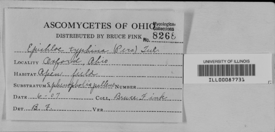
Specimen of unnamed1907Bruce Fink
Specimen of Catocala flebilis Grote, 1872Catocala flebilis Grote, 18721940not recordedNavarre
Specimen of Pemphigus Hartig, 1839Pemphigus Hartig, 18391948C. MohrMassillon
A photograph of the species Carex granularis, not of this specimenCarex granularis Muhl. ex Willd.1836Collector unknownCanton
A photograph of the species Carex intumescens, not of this specimenCarex intumescens Rudge1836Collector unknownCanton
A photograph of the species Ectopistes migratorius, not of this specimenEctopistes migratorius (Linnaeus, 1766)1875not recordedNo specific locality recorded.
A photograph of the species Archilochus colubris, not of this specimenArchilochus colubris (Linnaeus, 1758)1885Bulley, R. HCanton
A photograph of the species Dumetella carolinensis, not of this specimenDumetella carolinensis (Linnaeus, 1766)1885Bulley, R. HCanton
A photograph of the species Hylocichla mustelina, not of this specimenHylocichla mustelina (Gmelin, 1789)1885Bulley, R. HCanton
A photograph of the species Icterus galbula, not of this specimenIcterus galbula (Linnaeus, 1758)1885not recordedCanton
A photograph of the species Melospiza georgiana, not of this specimenMelospiza georgiana (Latham, 1790)1885Bulley, R. HCanton
A photograph of the species Molothrus ater, not of this specimenMolothrus ater ater (Boddaert, 1783)1885Bulley, R. HCanton

All 324 specimens within 10 miles, at the Global Biodiversity Information Facility.

Mines and quarries near this property

10 of 17 shown

Regional context, not property-specific evidence. The federal mineral resources record lists 17 workings within 5 miles of Eagles' Temple: 8 past producers, 8 producers, 1 plant. 9 still produce. What was taken out: Sand and Gravel, Construction, Clay, Sulfur, Stone, Crushed/Broken. Distance is straight-line from the map coordinates, so a quarry counted here may appear on a neighbouring settlement's page as well.

Where SiteCommodity StatusRecorded
Canton Ohio Sulfur PlantSulfurProducer
Ohio Ferro-Alloys/ Canton, OhioIronProducer
Sme QuarryStone, Crushed/BrokenProducer
Motts and Dehoff PitClayPast ProducerSedimentary
Stark County MinesClayProducer
Suzie Strip MineClayPast ProducerSedimentary
Suzie Strip Mine Clay and Shale PitClayPast Producer
American Sand & Gravel Plant #2 PitSand and Gravel, ConstructionProducer
Beldon Sand and Gravel PitSand and Gravel, ConstructionPast ProducerSedimentary
Beldon Sand and Gravel PitSand and Gravel, ConstructionPast Producer

Every working recorded in Stark County

Storms near this property

60 of 138 shown

Regional context, not property-specific evidence. The National Weather Service names Canton, the town this property stands in, in 138 storm reports between 1993 and 2026: 65 thunderstorm wind, 56 hail, 9 flash flood, 6 lightning. The reports record 3 injuries. Each account below is quoted exactly as the forecast office filed it, from the NOAA Storm Events Database, and each date opens the federal record of that event.

WhenEvent Place namedHarm What the report says
April 1994Thunderstorm WindCanton1 hurt, $500,000Winds to at least 70 mph, possibly from a microburst, damaged several stores in the College shopping area. Windows were shattered and signs downed. A woman sales clerk in the cactus area of a Woolworth's store had to be treated for wounds received from airborn objects and debris.
May 2001Tornado (F1)Canton1 hurt, $450,000A tornado touched down briefly on the southwest side of Canton. The tornado first touched down near the intersection of 13th Street and Raff Road where a semi truck was thrown 50 to 100 feet. An occupant inside the truck sustained minor injuries. The tornado remained on the ground for approximately one half mile and blew over seven additional tractor trailers. A roof was torn off of a warehouse and a nearby garage was also damaged. Many trees were knocked down.
July 2005LightningNorth Canton1 hurtA man was thrown nearly twenty feet after being struck by lightning. Reports indicate that the man only suffered minor injuries.
July 2008HailNorth Canton$5,000,000Golf ball size hail was reported in North Canton. Many vehicles were damaged by the hail.
June 2014Flash FloodNorth Canton$1,500,000On the evening of June 18th heavy rain fell over northern Stark County between 6 and 7 PM. A automated rain gauge in Alliance measured 1.35 inches in that one hour. This intense rain on saturated ground and still flooded portions of town led to flash flooding and more intense damage to the Plain Township area. Two homes on Chaucer Street in Sherwood Village collapsed when their foundations gave way. Several other homes have sanitary sewer problems. More than 100 residents whose property sustained flood damage. 10-14 people were evacuated that evening from an apartment complex which was inundated with 18 of flood waters from a tributary of the Middle Branch of the Nimishillen Creek. Homes on Arboretum Circle were also evacuated on Wednesday night from the Zimber Ditch. Numerous roads sustained erosion and tar removal from the flowing water. Graybill Road between Massillon Road and Mayfair Road suffered erosion. Berna Road was closed for two weeks to repair two damaged pipes. Greensburg Road, near the 1600 block of Nimisila Road was also damaged by flood waters.
January 2017FloodCanton$500,000Heavy rainfall averaging 1.5-2.84 across the Nimishillen Creek basin resulted in major flooding in the Canton and Perry township areas. In all six homes were inundated displacing families. The river rose quickly along with it's tributaries the East, West, and Middle Branches during the afternoon on the 12th. Water quickly surrounded apartment buildings in a low-lying area at the Gazebo Garden Apartments on Constitution Avenue in Louisville. About a dozen families were evacuated. The city parks in Canton were closed. In Perry Township two houses were surrounded by water off of Navarre Road SW. In Canton twenty families were evacuated from a mobile home park off Cleveland Avenue. The flood levels reached in this event were comparable with one in 2004 and 2011, yet due primarily to mitigation efforts the impacts were significantly less.
July 2000LightningNorth Canton$175,000Lightning struck a twelve unit apartment building and caused a fire.
August 2007Thunderstorm WindCanton$150,000Numerous trees, large limbs and power lines were reported down from just north of the Akron-Canton Airport east to near State Route 183.
April 2001HailCanton$125,000Hail the size of eggs fell near the intersection of Interstate 77 and US Highway 30 and damaged many cars.
July 2006Thunderstorm WindCanton$100,000Numerous trees were reported down in Plain Township. Also, several carports were flattened at an apartment complex. Some of the fallen trees and large limbs landed on houses causing damage.
May 2003Flash FloodCanton$100,000Thunderstorms dumped between two and three inches of rain on Canton in a short period of time. Widespread lowland and street flooding occurred. Water up to six feet deep was reported in downtown Canton with water up to four feet deep on U.S. Highway 30 and State Route 43. Several cars were stranded in the flood waters and a few buildings sustained minor damage.
April 2001HailCanton$100,000Hail the size of eggs was reported on the southwest side of Canton. Many cars were damaged.
April 2001HailCanton$100,000Golf ball size hail fell in downtown Canton.
June 2000Thunderstorm WindCanton$100,000Thunderstorm winds downed many trees and large limbs in the Canton and Waco areas. A 250 foot section of roof was peeled off of a building on the southwest side of Canton.
August 1998LightningCanton$80,000Lightning struck a house in Canton Township. The resulting fire caused major damage.
May 2004Thunderstorm WindCanton$75,000Thunderstorm winds downed around two dozen trees. At least four homes were damaged by fallen trees.
June 1998LightningCanton$70,000Lightning struck a house, and the ensuing fire destroyed it.
May 2012Flash FloodNorth Canton$50,000Between 620 PM and 635 PM a torrential shower moved over the Beldon Village are in North Canton located just west of I-77. The shower lasted only 15 minutes, however during a 10 minute period rainfall rates jumped to 4.36 in/hr as estimated by NWS Doppler Radar. No gauges were located at the site of the flooding, but radar estimates put this rate around a 100 year rain for this part of Ohio. This extreme rate overwhelmed drainage systems with excessive runoff. The impact area was limited to a 1/4 to a 1/2 mile radius from the Beldon Village Mall. The parking lot of the mall with over 4 feet of water, manhole covers were blown off from the water pressure of the stormwater system, and several nearby roads flooded. A number of businesses were flooded including a grocery store and a fast food restaurant with as much as 2 feet of water. Several cars were flooded and one woman needed to be rescued. Storm total rainfall estimates were a little over an inch, however the extreme rainfall rates were the cause to the damage in this event.
November 2002Thunderstorm WindCanton$50,000Thunderstorm winds downed scattered trees from Canton and Plain Township eastward through the Louisville and Alliance areas. A few cars were damaged by fallen trees and limbs.
June 2002Thunderstorm WindNorth Canton$50,000Thunderstorm winds downed a few trees in Plain and Lake Townships. A home was damaged by a tree in Lake Township west of Hartville.
May 2000LightningCanton$50,000Lightning struck a government building in Canton. Approximately $50,000 worth of radio and communications equipment was destroyed.
June 2000Flash FloodCanton$50,000Thunderstorms dumped heavy rains on the Canton area between 11 am and 5 pm. Rainfall measurements ranged from two and one half inches on the north side of Canton to nearly three and one half inches on the east side. Dozens of roads were flooded including some with several feet of water over them. A truck was washed off of a road in Monument Park. Flood waters also washed two cars off of Broadway Avenue. The cars floated several hundred yards before becoming stuck. Firefighters rescued the occupants of all three vehicles. Many other cars were stranded in high water.
September 1999Thunderstorm WindCanton$50,000Several trees downed. One tree landed on a house and garage. The house sustained broken windows and minor damage roof. The garage and an adjoining deck were destroyed.
October 1999Thunderstorm WindNorth Canton$50,000Ten to 15 power poles were downed by thunderstorm winds.
July 1997Thunderstorm WindCanton$50,000no account filed
July 2019Thunderstorm WindCanton$30,000A large tree smashed a car in a driveway and on a house. This report was a picture from social media. There were no injuries reported.
June 2002Thunderstorm WindCanton$30,000Thunderstorm winds downed several trees and large tree limbs. At least one home was damaged by a fallen tree and a second home had a chimney toppled.
September 2018Thunderstorm WindCanton$25,000Thunderstorm winds downed some utility poles and power lines along Hills and Dales Road.
November 2003Thunderstorm WindNorth Canton$25,000Thunderstorm wind gusts estimated at 60 mph downed many trees in and around North Canton.
May 2019Thunderstorm WindCanton$20,000A large tree was blown on a house. Multiple roads were blocked due to fallen trees and power lines in the Canton area.
November 2013Thunderstorm WindCanton$20,000Thunderstorm winds downed many trees across Stark County. The Hoover Appliance Company pedestrian walkway was also damaged.
June 2005HailCanton$20,000Quarter size hail was observed on the south side of Canton. A trained spotter had reported that the hail had accumulated on the ground to nearly an inch before tapering off. Other trained spotters had reported observing hail varying from penny to quarter size from Canton to Louisville.
June 2005Thunderstorm WindCanton$20,000A power company had reported several power poles down in the Canton area. Numerous large limbs were also reported downed from thunderstorm winds.
October 2001Thunderstorm WindNorth Canton$20,000Thunderstorm winds downed one tree in North Canton and a second in Alliance. A section of roof was torn off of a house in Canton.
September 1999Flash FloodCanton$20,000Up to two and one half inches of rain fell in about an hour causing street flooding throughout Canton. Two cars were trapped in three feet of water at the intersection of 15th Street and Yale Street.
July 2016Thunderstorm WindCanton$15,000Thunderstorm winds knocked a large tree down on top of a house.
July 2006Thunderstorm WindCanton$12,000Several large trees were reported down.
May 2019Thunderstorm WindCanton$10,000A large tree was blown down on a house in Canton. There was a picture of the damaged house on social media.
December 2013Thunderstorm WindCanton$10,000Thunderstorm winds downed a few trees.
July 2012Thunderstorm WindNorth Canton$10,000Thunderstorm winds downed a few trees.
March 2011HailCanton$10,000Pea to quarter sized hail was reported by numerous spotters across the county during this ten minute time period.
July 2005Thunderstorm WindCanton$10,000Several trees were reported down.
August 2005LightningCanton$10,000Lightning struck an oil tank and started a fire.
April 2002HailCanton$10,000Quarter size hail was reported.
May 2002HailCanton$10,000Quarter size hail was observed three miles south of Canton.
October 2001Thunderstorm WindCanton$10,000Thunderstorm winds downed many trees on the southwest side of Canton. A window was also blown out of a building.
August 1996Thunderstorm WindCanton$10,000no account filed
April 2023Thunderstorm WindCanton$5,000Large pine tree downed onto a house and caused minor roof damage in Canton.
May 2019Thunderstorm WindCanton$5,000Multiple trees and power lines were blown down in Canton.
July 2016Thunderstorm WindNorth Canton$5,000Thunderstorm winds downed a few trees.
June 2013Thunderstorm WindCanton$5,000Thunderstorm winds downed a couple of trees on Market Street.
June 2008Thunderstorm WindEast Canton$5,000Several large trees were uprooted.
May 2005Thunderstorm WindCanton$5,000Several trees reported down.
July 2003Thunderstorm WindCanton$5,000Thunderstorm winds downed two large trees three miles southwest of Canton.
April 2002HailCanton$5,000Dime size hail was reported.
April 2002HailCanton$5,000Dime size hail was reported near the intersection of Interstate 77 and U.S. Route 30.
May 1998Thunderstorm WindCanton$5,000Trees and power lines were downed.
August 1993Thunderstorm WindCanton$5,000Trees downed in several locations.
July 2006Thunderstorm WindNorth Canton$4,000Three trees were reported down.
May 2014Thunderstorm WindNorth Canton$3,000Thunderstorm winds downed a tree and a couple large limbs.

Every storm recorded in Stark County

Newspapers printed here

0 digitised pages

6 papers published in this town, digitised by the Library of Congress and free to read: 0 issues, 0 pages. Every page is searchable, so a name or a street can be looked for directly in what the town printed about itself at the time.

Map coverage status

No historic map-sheet match is published for this property yet. That does not mean no map exists. This record needs a coordinate-quality review before it can be joined to a sheet boundary. Browse the county's mapped places while that work is pending.

From the nomination file

1,578 words on record

When this property was proposed for the National Register, someone wrote the case for it: what the building is, and why it matters. That document is a federal record in the public domain. It is quoted below word for word, never summarised. The text was read off the scanned case file by machine, so the occasional stray character is the recogniser's and the 1970s typewriter's.

Description of the property

(and symbolic) bell-tower appurtenance, with its hipped red tile roof semi-circular arches and brick quoins, gives the building a Spanish Colonial Revival flavor that tends to over- by a simple stone veneer street level story whose original fenestration has been infilled simple, discrete fenestration in the upper stories surmounted by an attic story defined by The southern block of the structure continues the parapet and belt courses, but graphs, these windows featured crossed mullions and transoms similar to those found on windows and the restoration of other original elements of the facade. Condition unexposed ruins element. ride the Neo-Classical or Georgian Revival themes of its other features.

The Eagles' Temple is a five-story polychromatic commercial structure of red facing and is highlighted by three festooned,shield-shaped cartouches announcing"F","o"and Situated on a corner site, thebuilding's simple corner-facing frontpiece is flanked story windows infilled).A three-story triple arcaded facade dominates this elevation elaborates the arched theme of the central tower through arcaded brick course above the.top with redwood siding and aluminum door frames. The corner-oriented)block of the structure features brick quoins and Check one . deteriorated _ unaltered of this elevation opened into a ballroom called the "gold room". According to old photo- windows presently on the west rear elevation.

Plans call for the replacement of these date and scroll-like detailing.Carved terra cotta insets--panels and circles--decorate this "E"("Fraternal Order of Eagles").The windows infilled) that were original features Areas of Significance - Check and justify below _ science . literature - sculpture - architecture - military X social/ - music _ commerce X 1900 other (specify) Specific dates 1927-28 Builder/Architect Albert Thayer (architect); George Whike Statement of

Statement of significance

/Architect Albert Thayer (architect); George Whike Statement of Significance (in one paragraph) The Eagles' Temple is significant as the only structure ever build by Canton Aerie 141 (aerie meaning "nest" or local chapter) of the Fraternal Order of Eagles, the oldest aerie in Ohio. It is significant, as well, as one of the two-remaining commercial use modest building by standards applied elsewhere, perhaps, the Eagles' Temple, standing as until the mid 20's when, at the peak period of its growth, having, at the time of the Temples' dedication in 1928, 3,000 members, Aerie 141 purchased the property on South Market meetings, its fund raising and fraternity.

Today, the Eagles' Temple is one of a group of widely separated architectural remnants in the south end of Canton's downtown, on the edges of a cleared site known as "Newmarket" building. If this development takes place, the Eagles' Temple will provide evidence of the "middle period" in Canton's history, an architectural counterpoint to the earlier buildings in the area and the ones to be built in the future. 1600-1699 1700-1799 economics conservation Period engineering invention industry theater education law humanitarian (contractor) 8.

Significance it does in an area of Canton that has undergone extensive urban renewal clearance and structures in Canton's central business district built just prior to the Depression.A _1800-1899 - communications The first chapter of the Fraternal Order of Eagles--a nation-wide civic organization - prehistoric _ archeology-prehistoric community planning - archeology-historic - agriculture _art - philosophy Seattle in 1898. First called "The Order of Good Things", it was founded by four itinerant Street from the prominant Lehman family.

Read the complete 1,578-word case file.

The whole case file for this property - 1,578 words, 12 pages, reproduced complete.

Quoted from the National Register nomination for reference 82003646, 12 pages, held by the National Archives in Record Group 79. See the catalogue record.

Listed places nearby

6 within 8 miles

Other National Register properties close enough to walk or drive between, ordered by distance from this one. Both positions come from the same geocoding pass that matched these properties to their map sheets.

Photograph PropertyDistance Listed
Schuffenecker, August Buildingunder 500 feet1982
Frances Apartment Buildingunder 500 feet1988
Saxton House0.1 miles1979
Barber-Whitticar House0.1 miles1982
City National Bank Building0.2 miles1982
Canton Public Library0.2 miles1982

Sources for this property

National Archives recordThe nomination case file for reference 82003646 in Record Group 79.
Wikipedia articleCommunity-written account of this property, licensed CC BY-SA.
Stark CountyAll 81 listed properties in this county.

Provenance

  • Listing record. National Park Service National Register of Historic Places, listed-properties dataset, current to 2026-05-22.
  • Map join. Address geocoded through the United States Census geocoder, then tested against the published boundary of every sheet in the USGS Historical Topographic Map Collection.
  • How this page is made. Listing fields come from federal records; map-sheet coverage is a labelled coordinate-to-boundary calculation, not a source-field claim.
  • Wildfire. Short, Karen C. 2022. Spatial wildfire occurrence data for the United States, 1992-2020 [FPA_FOD_20221014]. 6th Edition. Fort Collins, CO: Forest Service Research Data Archive. https://doi.org/10.2737/RDS-2013-0009.6 Collected with United States Government funding and usable without additional permissions or fees.
  • Specimens. Global Biodiversity Information Facility (GBIF), https://www.gbif.org/. Only records licensed CC0 or CC BY are used. Records licensed CC BY-NC are excluded because this site carries advertising. Images are checked individually and any whose licence is non-commercial, no-derivatives or unreadable is refused.
  • Mines and quarries. USGS Mineral Resources Data System (MRDS) https://mrdata.usgs.gov/mrds/ A work of the United States government, no copyright under 17 U.S.C. 105.
  • Storms. NOAA National Centers for Environmental Information, Storm Events Database https://www.ncei.noaa.gov/stormevents/ A work of the United States government, no copyright under 17 U.S.C. 105. Narratives are quoted verbatim from the National Weather Service report and are not edited or summarised.