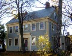
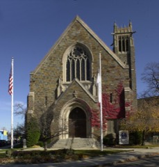
Built in 1640. Listed on the National Register of Historic Places in
1982. A historic map-sheet match is not published yet. The record needs a coordinate-quality review before it can be joined to a sheet boundary.
From the record
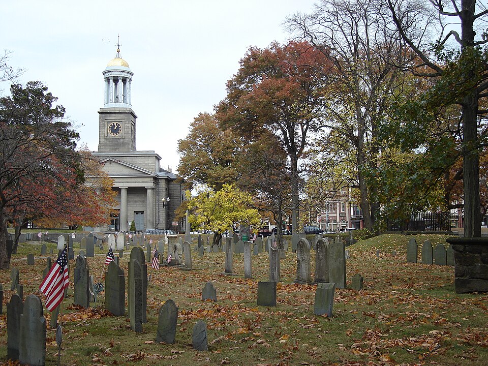
“Hancock Cemetery is a historic cemetery on the Hancock Adams Common, across from the United First Parish Church, in Quincy, Massachusetts, United States. It is named after Reverend John Hancock Jr.”
Wikipedia article Hancock Cemetery, CC BY-SA 4.0.
one of 249 National Register listings in Norfolk County · listed in 1982 · category: Site · built in 1640 · one of 2 National Historic Landmarks in Norfolk County.
National Register reference number.82004421- the number the National Park Service assigned this property when it was listed, and the key its nomination file is catalogued under at the National Archives.
Fires near this property
291 since 2015
Regional context, not property-specific
evidence. The
federal wildfire occurrence database
lists 291 fires within 5 miles of Hancock Cemetery between
2015 and 2020, burning about 134 acres in total. None started naturally. None was recorded as arson.
Distance is straight-line from the map coordinates, so a fire counted
here may appear on a neighbouring settlement's page as well.
Reported cause
Fires
Recreation and ceremony
184
Smoking
43
Missing data/not specified/undetermined
29
Debris and open burning
28
Misuse of fire by a minor
3
Equipment and vehicle use
2
Fireworks
2
The most recent of
them, most recent first, with the day each was reported and the service
that recorded it.
Regional context, not property-specific
evidence. Museums hold 10,023 specimens
collected within 10 miles of Hancock Cemetery between 1810 and
1975: 5,249 Plantae, 2,683 Animalia, 1,600 Fungi, 314 Chromista, 109 Protozoa, 50 Unrecorded, 18 Bacteria. 12 distinct Species records are shown.
Collected by (MARSDEN, H W), A C Gibson, A Loveridge and others. Each is a
physical object with a catalogue
number, and each entry opens the museum's record. This is what was
collected and kept, not a survey of what lives here - nothing can be
concluded from a species being absent.
Regional context, not property-specific
evidence. The federal mineral resources record lists
5 workings within 5 miles of Hancock Cemetery: 3 producers, 2 past producers.
3 still produce. What was taken out: Sand and Gravel, Construction, Granite, Stone, Crushed/Broken. Distance is straight-line from the
map coordinates, so a quarry counted here may appear on a neighbouring
settlement's page as well.
Regional context, not property-specific
evidence. The National Weather Service names
Quincy, the town this property stands in, in 29 storm reports between 1995 and 2025: 10 thunderstorm wind, 8 flood, 5 flash flood, 3 hail.
No death or injury is recorded in these reports. Each account below is quoted exactly as the forecast office
filed it, from the NOAA Storm Events Database, and each date
opens the federal record of that event.
Several streets in the area of Quincy, Braintree, and Milton were flooded with one to two feet of water. One car was stuck in flood waters at Granite and Chickatawbut Roads in Quincy.
In Quincy, a tree was down on a car at the intersection of Evans Street and West Squantum Street. A person was trapped and extricated, but fortunately was uninjured. Police report relayed by amateur radio.
No historic map-sheet match is published
for this property yet. That does not mean no map exists. This record needs
a coordinate-quality review before it can be joined to a sheet boundary.
Browse the county's mapped places while that work is
pending.
From the nomination file
2,046 words on record
When this property was proposed for the
National Register, someone wrote the case for it: what the building is,
and why it matters. That document is a federal record in the public domain.
It is quoted below word for word, never summarised. The text was read off the scanned case file by machine, so the
occasional stray character is the recogniser's and the 1970s
typewriter's.
Description of the property
The Hancock Cemetery is a grassy,. wooded plot of slightly more than two acres in the civic and commerical center of Quincy. It lies west of Hancock Street and east of the former 0ld Colony Railroad line. The Quincy City Hall (NR 1980) forms its northern bound while the First Parish Church Unitarian (NHL, 1970) stands across the street. The site is trapezoidal in plan with a 225' frontage on Hancock Street which is marked by an ornamental mid-19th century cast iron fence set on a low cut granite retaining wall. This is interrupted bytwo-symmetrically placed entrances consisting of granite posts which support cast iron arches bearing gold leafed mottos.
The southerly entrance reads "Dust Thou Art And Unto Dust Thy Shall Return"while that to the north reads "This Mortal Shall Put On Immortality." Mature hardwood trees along with a variety of flowering shrubs are clustered throughout the ground which 1s crisscrossed by wandering asphalt covered paths. Stones, dating from the I/th, l8th, and 19th centuries are laid out at random; the earliest are generally of slate while those built dating after 1820 are usually marble or granite. Family tombs which are built into the banked sides of the cemetery,date primarily from the early 19th century.
Statement of significance
/Architect religion - science - sculpture social/ humanitarian theater transportation - other (specify) HISTORY Statement of Significance (in one paragraph) The Hancock Cemetery possesses integrity of location, design, materials, and workmanship as well as important historical associations with the seventeenth century origins of Quincy Center, with families of local, state, and national repute, and with the early development of gravestone art in New England. and Randolph.
The present Quincy center served as the focus of this larger community and It is believed that there were burials on this site from the time of the earliest settlement but there was no formal mention of this use until after 1640 when the surrounding land was acquired by Captain William Tynge, a prominent citizen, large landowner, and second commander of the local militia company. The burying ground remained on private lands until the town took official custody in 1809. From the distribution of early graves, it appears that its area was always close to its present 2 acres; the only addition was a strip at the south end in 1819 when the townhouse was built on the adjoining lot (north) and land was made available for tombs.
The ornamental 1819 w%en ose towhouse was bui1 tence the fence which presently fronts Hancock Street was put up under the auspices of the Ladies of the Church in 1844, the year in which the present City Hall (NR) was erected. The oldest identified grave is that of Henry Adams, progenitor of the famous family, who died here in 1646. The monument now marking the grave was placed here by his great, great grandson, President John Adams, who similarly honored his father, grandfather, and great grandfather. These monuments have recently been restored by the family.
Quoted from the National Register nomination
for reference 82004421, 12 pages, held by the National Archives in Record
Group 79. See the
catalogue record.
Listed places nearby
6 within 8 miles
Other National Register properties close
enough to walk or drive between, ordered by distance from this one. Both
positions come from the same geocoding pass that matched these properties
to their map sheets.
Listing record. National Park Service National Register of Historic Places, listed-properties dataset, current to 2026-05-22.
Map join. Address geocoded through the United States Census geocoder, then tested against the published boundary of every sheet in the USGS Historical Topographic Map Collection.
How this page is made. Listing fields come from federal records; map-sheet coverage is a labelled coordinate-to-boundary calculation, not a source-field claim.
Wildfire. Short, Karen C. 2022. Spatial wildfire occurrence data for the United States, 1992-2020 [FPA_FOD_20221014]. 6th Edition. Fort Collins, CO: Forest Service Research Data Archive. https://doi.org/10.2737/RDS-2013-0009.6 Collected with United States Government funding and usable without additional permissions or fees.
Specimens. Global Biodiversity Information Facility (GBIF), https://www.gbif.org/. Only records licensed CC0 or CC BY are used. Records licensed CC BY-NC are excluded because this site carries advertising. Images are checked individually and any whose licence is non-commercial, no-derivatives or unreadable is refused.
Mines and quarries. USGS Mineral Resources Data System (MRDS) https://mrdata.usgs.gov/mrds/ A work of the United States government, no copyright under 17 U.S.C. 105.
Storms. NOAA National Centers for Environmental Information, Storm Events Database https://www.ncei.noaa.gov/stormevents/ A work of the United States government, no copyright under 17 U.S.C. 105. Narratives are quoted verbatim from the National Weather Service report and are not edited or summarised.
 Block
Block