Listed on the National Register of Historic Places in
1982. A historic map-sheet match is not published yet. The record needs a coordinate-quality review before it can be joined to a sheet boundary.
From the record
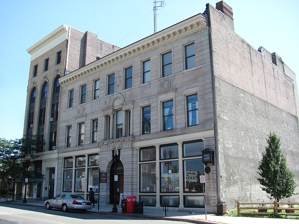
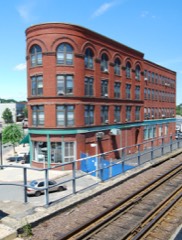
“The Lynn Bank Block is a historic bank building at 21-29 Exchange Street in Lynn, Massachusetts. The three-story building was built for the First National Bank of Lynn and the Lynn Institution for Savings in 1891.”
Wikipedia article Lynn Bank Block, CC BY-SA 4.0.
one of 350 National Register listings in Essex County · listed in 1982 · category: Building · one of 2 National Historic Landmarks in Essex County.
National Register reference number.82004964- the number the National Park Service assigned this property when it was listed, and the key its nomination file is catalogued under at the National Archives.
The following pages will give some account of this numerous family, descended, as will be shown, from two brothers who probably settled in the town of Lynn about A. D. 1630. Their names are to be found on the list of grantees of lots in a division of lands in 1638, as appears in the papers on file in the office of the Clerk of the Courts for Essex County, in the case of William Longley vs. the Town of Lynn, March Term, 1660-1.
The Lynn Records inform us that Thomas Newhall, Sonr, was buried the first of April, 1(>S7. He probably left a Will ; for, on the 14th of April, 1687, an Inventory of Ensigne Thomas Newhall of Lynn, late deceased, appraised 8th of April, 1G87, by John Fuller, Son1'. Ralph King and John Burrill, was presented by John Newhall, "one of the Executors," and is recorded in Suffolk County : but no record of the Will appears and neither Will nor
Regional context, not property-specific
evidence. The
federal wildfire occurrence database
lists 75 fires within 5 miles of Lynn Bank Block between
2003 and 2020, burning about 252 acres in total. 1 started naturally. 7 were recorded as arson.
Distance is straight-line from the map coordinates, so a fire counted
here may appear on a neighbouring settlement's page as well.
Reported cause
Fires
Recreation and ceremony
26
Smoking
16
Debris and open burning
7
Arson/incendiarism
7
Missing data/not specified/undetermined
6
Misuse of fire by a minor
4
Equipment and vehicle use
4
Fireworks
3
Natural
1
Railroad operations and maintenance
1
The most recent of
them, most recent first, with the day each was reported and the service
that recorded it.
Regional context, not property-specific
evidence. Museums hold 10,564 specimens
collected within 10 miles of Lynn Bank Block between 1800 and
1975: 5,078 Plantae, 2,939 Animalia, 1,006 Chromista, 831 Fungi, 408 Unrecorded, 289 Bacteria, 13 Protozoa. 12 distinct Species records are shown.
Collected by A B. Proper, A. A. Eaton, A. B. Hervey and others. Each is a
physical object with a catalogue
number, and each entry opens the museum's record. This is what was
collected and kept, not a survey of what lives here - nothing can be
concluded from a species being absent.
Regional context, not property-specific
evidence. The federal mineral resources record lists
11 workings within 5 miles of Lynn Bank Block: 3 past producers, 3 producers, 2 unknowns, 2 plants.
5 still produce. What was taken out: Stone, Crushed/Broken, Sand and Gravel, Construction, Iron, Gold. Distance is straight-line from the
map coordinates, so a quarry counted here may appear on a neighbouring
settlement's page as well.
Regional context, not property-specific
evidence. The National Weather Service names
Lynn, the town this property stands in, in 37 storm reports between 2006 and 2023: 16 thunderstorm wind, 9 hail, 5 flood, 5 flash flood.
No death or injury is recorded in these reports. Each account below is quoted exactly as the forecast office
filed it, from the NOAA Storm Events Database, and each date
opens the federal record of that event.
Numerous trees and wires were downed throughout Lynn, closing thirty to forty streets. An amateur radio operator recorded a wind gust of 60 mph on their home weather station on Centre Street.
At 9:16 AM EST, cars on Monroe Street in Lynn were floating in the street. At 9:18 AM EST, water was rising in a building on Monroe Street, causing people to stand on chairs. At 9:31 AM cars were trapped in flood waters on Chatham Street under a bridge; the road was impassable. At 10:03 AM the basement door to a building on Union Street had collapsed due to the flooding, and water was pouring in. At 10:18 AM, large sections of Boston Street in Lynn were flooded and impassable, and several cars were trapped in the floodwaters. At 10:32 AM state route 107 on the Lynn/Salem border was closed due to flooding. At 10:59 AM EST, manhole covers were reported coming off the road on Seymour Avenue. A car was trapped in three feet of water on Wilfred Street; the road was impassable. At 11:42 AM EST, street flooding on Erie Street reached several feet.
Lightning struck a three family home on Washington Street, setting fire to the house. Damage was to the front roof in the third floor unit. Residents in the third floor unit were unable to return to their unit due to water damage. Other units were not damaged.
In Swampscott, a car was stuck in flood waters at the Santander Bank parking lot. Crowinshield Street was flooded in Peabody. A car was stuck in flood waters on Endicott Street. Leather City Common was flooded with six to twelve inches of water.
In Peabody, a car was stuck in two feet of water on America Drive. A car was stuck in flood waters on the ramp for the Northshore Mall from Route 114 to Route 128. In Lynn, four to six inches covered all three eastbound lanes of the Lynnway. Other streets in Lynn were flooded with three feet of water and the fire department responded to two calls of people stuck in their cars. In Beverly, Federal Street between MacPherson Drive and Rantoul and Lothrop Street at Route 127 were closed due to flooding. The fire department reported several streets flooded with at least 3 feet of water. They responded to about a half dozen calls of people stuck in their cars. In Salem, Highland Avenue was flooded out.
In Lynn, large branches and wires were downed by thunderstorm winds. In Marblehead, trees and wires on Green Street and Kenneth Road were downed by thunderstorm winds. One of the trees on Kenneth Road landed on a house.
A tree and wires were downed onto a fence on Warwick Street in Lynn. Also, an eight inch diameter tree branch was downed and blew into a house, the house sustained minor damage. Several other tree limbs were downed on Lynnfield Street and Savory Street.
In Swampscott, several cars were stuck in street flooding on Paradise Road (Route 1A). |Also, a car was stuck at the intersection of Stetson Avenue and Norfolk Avenue.
No historic map-sheet match is published
for this property yet. That does not mean no map exists. This record needs
a coordinate-quality review before it can be joined to a sheet boundary.
Browse the county's mapped places while that work is
pending.
From the nomination file
2,438 words on record
When this property was proposed for the
National Register, someone wrote the case for it: what the building is,
and why it matters. That document is a federal record in the public domain.
It is quoted below word for word, never summarised. The text was read off the scanned case file by machine, so the
occasional stray character is the recogniser's and the 1970s
typewriter's.
Description of the property
N/A The Lynn Bank Block stands on the south side of Exchange Street between Union and Spring Streets, immediately east of the elevated railroad crossing of the Boston and Maine Railroad. Built to be part of a row of commercial buildings, the block is attached to a neighboring structure on its east elevation; however, its western party wall is now exposed due to the demolition of abutting buildings. The Bank Block has a rectangular plan consisting of a three-storey front section (north) and a one-storey rear wing (south) which was added in 1931. Both sections are enc bsed by flat tar-and-gravel roofs and are built of masonry with wood and steel framing. symmetrical facade (north) is faced with dressed límestone set on a granite plinth.
Limestone finishes vary from heavy rustication on piers at the first storey to rusticated ashlar on upper floors and a band of dressed ashlar with four wreaths carved in low relief between the second and third stories. These wreaths bear various inscriptions, i.e., "1814" (date of the bank's incorporation), "1891" (date of the block's construction), "FNB" (First National Bank) and "IFS" (Institution for Savings). The facade's first storey is dominated by an arched entry (doors replaced ca. 1956) surmounted by a damaged keystone, a course of carved fleur-de-lis and a cornice decorated with carved lion's heads.
Flanking the entry are two sets of store fronts, each of which is framed by panelled iron pilasters into three bays; at the first storey each of these bays contains a transom and a single fixed light set over a panelled base.
/Architect James T. Kelley,Architect (1891) Thomas M. James Co. (1931) Statement of Significance (in one paragraph) James, Thamas M., Co. The Lynn Bank Block possesses integrity of location, design, setting, materials and workmanship, as well as historical association with the reconstruction of Lynn's com- mercial district after the Fire of 1889 and the development of the City's important shoe industry throughout the nineteenth century. Additionally, it was the first building constructed in downtown Lynn after the devastating fire to employ a classical design vocabulary. Thus, the building meets criteria A & C of the NRHP.
Between 1891 and the early 1970s, the Bank Block served as the main offices of the Lynn Institution for Savings (chartered as a savings bank in 1826) and the Lynn First National Bank (chartered as a commercial bank in 1814 as the Mechanics' Bank; re-in- corporated as the Essex Trust Company in 1904). Founded by local shoemakers, these two institutions, especially the former Mechanics' Bank, played an essential role in the development of the shoe industry in Lynn by discounting the notes of credit with which Southern and Western buyers paid local manufacturers for boots and shoes. As early as 1804, such notes amounted to $500,000 annually and proved a severe hindrance to shoemakers who needed cash to purchase raw materials.
With the founding of the Mechanics' Bank, this credit problem was solved and a continuing relationship was established between the bank and the local shoe manufacturers, a relationship that was reflected in the large number of shoe manufacturers who served on the bank's Board of Directors throughout the nineteenth and early twentieth centuries.
Quoted from the National Register nomination
for reference 82004964, 11 pages, held by the National Archives in Record
Group 79. See the
catalogue record.
Listed places nearby
6 within 8 miles
Other National Register properties close
enough to walk or drive between, ordered by distance from this one. Both
positions come from the same geocoding pass that matched these properties
to their map sheets.
Listing record. National Park Service National Register of Historic Places, listed-properties dataset, current to 2026-05-22.
Map join. Address geocoded through the United States Census geocoder, then tested against the published boundary of every sheet in the USGS Historical Topographic Map Collection.
How this page is made. Listing fields come from federal records; map-sheet coverage is a labelled coordinate-to-boundary calculation, not a source-field claim.
Wildfire. Short, Karen C. 2022. Spatial wildfire occurrence data for the United States, 1992-2020 [FPA_FOD_20221014]. 6th Edition. Fort Collins, CO: Forest Service Research Data Archive. https://doi.org/10.2737/RDS-2013-0009.6 Collected with United States Government funding and usable without additional permissions or fees.
Specimens. Global Biodiversity Information Facility (GBIF), https://www.gbif.org/. Only records licensed CC0 or CC BY are used. Records licensed CC BY-NC are excluded because this site carries advertising. Images are checked individually and any whose licence is non-commercial, no-derivatives or unreadable is refused.
Mines and quarries. USGS Mineral Resources Data System (MRDS) https://mrdata.usgs.gov/mrds/ A work of the United States government, no copyright under 17 U.S.C. 105.
Storms. NOAA National Centers for Environmental Information, Storm Events Database https://www.ncei.noaa.gov/stormevents/ A work of the United States government, no copyright under 17 U.S.C. 105. Narratives are quoted verbatim from the National Weather Service report and are not edited or summarised.
 Block
Block