Listed on the National Register of Historic Places in
1983. A historic map-sheet match is not published yet. The record needs a coordinate-quality review before it can be joined to a sheet boundary.
From the record
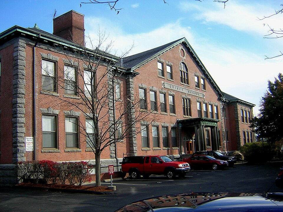
“Quincy School is a historic school building at 94 Newbury Avenue in Quincy, Massachusetts. The two-story brick building was built in 1906 and enlarged in 1932; its original design was by Hurd & Gore, and the addition was by Hutchins & French.”
Wikipedia article Quincy School, CC BY-SA 4.0.
one of 249 National Register listings in Norfolk County · listed in 1983 · category: Building · one of 2 National Historic Landmarks in Norfolk County.
National Register reference number.83000599- the number the National Park Service assigned this property when it was listed, and the key its nomination file is catalogued under at the National Archives.
Fires near this property
168 since 2015
Regional context, not property-specific
evidence. The
federal wildfire occurrence database
lists 168 fires within 5 miles of Quincy School between
2015 and 2020, burning about 81 acres in total. None started naturally. None was recorded as arson.
Distance is straight-line from the map coordinates, so a fire counted
here may appear on a neighbouring settlement's page as well.
Reported cause
Fires
Recreation and ceremony
121
Smoking
30
Missing data/not specified/undetermined
15
Debris and open burning
1
Equipment and vehicle use
1
The most recent of
them, most recent first, with the day each was reported and the service
that recorded it.
Regional context, not property-specific
evidence. Museums hold 11,566 specimens
collected within 10 miles of Quincy School between 1810 and
1975: 5,337 Plantae, 2,841 Fungi, 2,760 Animalia, 356 Chromista, 188 Protozoa, 54 Unrecorded, 30 Bacteria. 12 distinct Species records are shown.
Collected by (MARSDEN, H W), ?, A C Gibson and others. Each is a
physical object with a catalogue
number, and each entry opens the museum's record. This is what was
collected and kept, not a survey of what lives here - nothing can be
concluded from a species being absent.
Regional context, not property-specific
evidence. The federal mineral resources record lists
3 workings within 5 miles of Quincy School: 2 producers, 1 past producer.
2 still produce. What was taken out: Granite, Stone, Crushed/Broken, Sand and Gravel, Construction. Distance is straight-line from the
map coordinates, so a quarry counted here may appear on a neighbouring
settlement's page as well.
Regional context, not property-specific
evidence. The National Weather Service names
Quincy, the town this property stands in, in 29 storm reports between 1995 and 2025: 10 thunderstorm wind, 8 flood, 5 flash flood, 3 hail.
No death or injury is recorded in these reports. Each account below is quoted exactly as the forecast office
filed it, from the NOAA Storm Events Database, and each date
opens the federal record of that event.
Several streets in the area of Quincy, Braintree, and Milton were flooded with one to two feet of water. One car was stuck in flood waters at Granite and Chickatawbut Roads in Quincy.
In Quincy, a tree was down on a car at the intersection of Evans Street and West Squantum Street. A person was trapped and extricated, but fortunately was uninjured. Police report relayed by amateur radio.
No historic map-sheet match is published
for this property yet. That does not mean no map exists. This record needs
a coordinate-quality review before it can be joined to a sheet boundary.
Browse the county's mapped places while that work is
pending.
From the nomination file
1,789 words on record
When this property was proposed for the
National Register, someone wrote the case for it: what the building is,
and why it matters. That document is a federal record in the public domain.
It is quoted below word for word, never summarised. The text was read off the scanned case file by machine, so the
occasional stray character is the recogniser's and the 1970s
typewriter's.
Description of the property
The Quincy School stands on a high and level lot at the corner of Newbury Avenue and Botolph Street in northern Quincy. A shallow, unlandscaped lawn occupies the front and sides of its 1 1/3-acre site. Although the surrounding neighborhood is primarily residential, a block of stores faces the school on the west across a heavily travelled street. On the south side of the site is a residential street, while residents' rear and side yards abut the property on its northern and eastern boundaries. Built in two parts, Quincy School maintains a uniform Neo-Colonial design. Two- story brick walls are framed by a granite ashlar foundation, granite quoins and frieze, and a copper cornice (with modillion blocks on the early section).
The original (1906) building is a basically rectangular structure; it incorporates a central block with a shallow gabled frontispiece of 2½ stories, flanked by end pavilions. Its hipped slate roof is ornamented by copper ridge flashing with decorative knobs. Five chimneys (four interior and one exterior) and three rear dormers enliven the roofline. Iwo large flat-roofed ells were added at the rear in 1932, creating a U-shaped structure. The symmetrical fenestration of the school consists of grouped windows which are articulated by granite sills and flared granite lintels with keystones. Windows overlooking the rear courtyard do not have the keystones.) Original 12/2 wooden sash were replaced in 1977 by plexiglass, 1/1 sash in bronzed aluminum frames.
Three similar, round arched doorways are located on the facade and on the rear of the ells.. A plain entry porch connects the front of the building and the southern ell, providing a fourth doorway on the southern side. Forming the primary visual focus of this design, however, is the wide gabled frontispiece.
(in one paragraph) Builder/Architect BroS. Bifidei Architect, 1906; Mari ros. Hutchins & French, Architects(1932) M. J. Kelliher, Builder Quincy School is significant as a well designed and preserved example of early 20th century institutional architecture in Quincy and as a reflection of intensive civic growth at that time. The property meets criteria A and C of the National Register, retaining integrity of design, materials, workmanship, location, and setting. In 1906 the City of Quincy appropriated $61,000 for the construction of a 12-room grammar school in the Atlantic section of North Quincy. Quincy School was named after the prominent local family and was first occupied on September 10, 1907.
It was equipped with all the modern conveniences, including electric lighting, telephones, and an automatic clock system. At the time of construction, the number of pupils in the school district was 280, far less than what the Quincy School was designed to accommodate. However, population increases over the next 25 years caused the City Council in 1931 to appropriate $150,00 for an 8-room addition; construction of the two ells was completed in February, 1932. The original building was designed by the Boston firm of Hurd and Gore, who were known for their Boston apartment buildings. Marr Brothers of Quincy were the builders of this section. The rear ells were designed by Hutchins and French, Boston architects who specialized in bank buildings constructed throughout New England. M. J.
Kelliher was the contractor. Construction of the Quincy School reflects an important period of growth in Quincy. Population doubled every 20 years from ca. 1870 through 1915. On the larger scale, this precipitated Quincy's incorporation as a city in 1888, and resulted in a flurry of distinguished institutional buildings during the late Victorian period.
Quoted from the National Register nomination
for reference 83000599, 13 pages, held by the National Archives in Record
Group 79. See the
catalogue record.
Listed places nearby
6 within 8 miles
Other National Register properties close
enough to walk or drive between, ordered by distance from this one. Both
positions come from the same geocoding pass that matched these properties
to their map sheets.
Listing record. National Park Service National Register of Historic Places, listed-properties dataset, current to 2026-05-22.
Map join. Address geocoded through the United States Census geocoder, then tested against the published boundary of every sheet in the USGS Historical Topographic Map Collection.
How this page is made. Listing fields come from federal records; map-sheet coverage is a labelled coordinate-to-boundary calculation, not a source-field claim.
Wildfire. Short, Karen C. 2022. Spatial wildfire occurrence data for the United States, 1992-2020 [FPA_FOD_20221014]. 6th Edition. Fort Collins, CO: Forest Service Research Data Archive. https://doi.org/10.2737/RDS-2013-0009.6 Collected with United States Government funding and usable without additional permissions or fees.
Specimens. Global Biodiversity Information Facility (GBIF), https://www.gbif.org/. Only records licensed CC0 or CC BY are used. Records licensed CC BY-NC are excluded because this site carries advertising. Images are checked individually and any whose licence is non-commercial, no-derivatives or unreadable is refused.
Mines and quarries. USGS Mineral Resources Data System (MRDS) https://mrdata.usgs.gov/mrds/ A work of the United States government, no copyright under 17 U.S.C. 105.
Storms. NOAA National Centers for Environmental Information, Storm Events Database https://www.ncei.noaa.gov/stormevents/ A work of the United States government, no copyright under 17 U.S.C. 105. Narratives are quoted verbatim from the National Weather Service report and are not edited or summarised.
 Block
Block