Listed on the National Register of Historic Places in
1984. A historic map-sheet match is not published yet. The record needs a coordinate-quality review before it can be joined to a sheet boundary.
From the record
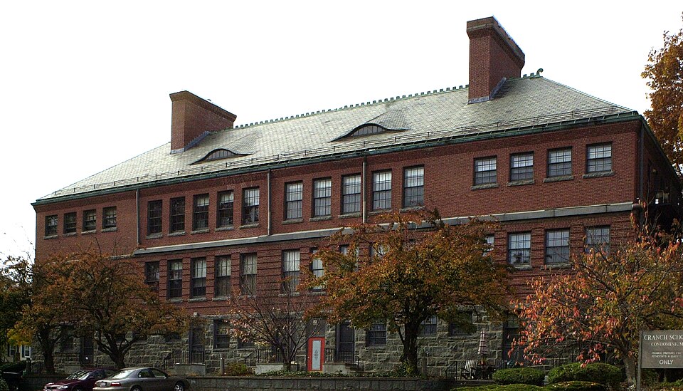
“The Cranch School is a historic school building at 250 Whitwell Street in Quincy, Massachusetts. Built in 1900 to a design by local architect Arthur Wright, it is a high-quality local example of Renaissance Revival and Queen Anne architecture.”
Wikipedia article Cranch School, CC BY-SA 4.0.
one of 249 National Register listings in Norfolk County · listed in 1984 · category: Building · one of 2 National Historic Landmarks in Norfolk County.
National Register reference number.84002872- the number the National Park Service assigned this property when it was listed, and the key its nomination file is catalogued under at the National Archives.
Fires near this property
287 since 2015
Regional context, not property-specific
evidence. The
federal wildfire occurrence database
lists 287 fires within 5 miles of Cranch School between
2015 and 2020, burning about 160 acres in total. None started naturally. None was recorded as arson.
Distance is straight-line from the map coordinates, so a fire counted
here may appear on a neighbouring settlement's page as well.
Reported cause
Fires
Recreation and ceremony
192
Smoking
41
Missing data/not specified/undetermined
25
Debris and open burning
22
Misuse of fire by a minor
3
Equipment and vehicle use
2
Fireworks
2
The most recent of
them, most recent first, with the day each was reported and the service
that recorded it.
Regional context, not property-specific
evidence. Museums hold 11,410 specimens
collected within 10 miles of Cranch School between 1810 and
1975: 5,338 Plantae, 2,747 Animalia, 2,710 Fungi, 342 Chromista, 192 Protozoa, 51 Unrecorded, 30 Bacteria. 12 distinct Species records are shown.
Collected by (MARSDEN, H W), ?, A C Gibson and others. Each is a
physical object with a catalogue
number, and each entry opens the museum's record. This is what was
collected and kept, not a survey of what lives here - nothing can be
concluded from a species being absent.
Regional context, not property-specific
evidence. The federal mineral resources record lists
5 workings within 5 miles of Cranch School: 3 producers, 2 past producers.
3 still produce. What was taken out: Sand and Gravel, Construction, Granite, Stone, Crushed/Broken. Distance is straight-line from the
map coordinates, so a quarry counted here may appear on a neighbouring
settlement's page as well.
Regional context, not property-specific
evidence. The National Weather Service names
Quincy, the town this property stands in, in 29 storm reports between 1995 and 2025: 10 thunderstorm wind, 8 flood, 5 flash flood, 3 hail.
No death or injury is recorded in these reports. Each account below is quoted exactly as the forecast office
filed it, from the NOAA Storm Events Database, and each date
opens the federal record of that event.
Several streets in the area of Quincy, Braintree, and Milton were flooded with one to two feet of water. One car was stuck in flood waters at Granite and Chickatawbut Roads in Quincy.
In Quincy, a tree was down on a car at the intersection of Evans Street and West Squantum Street. A person was trapped and extricated, but fortunately was uninjured. Police report relayed by amateur radio.
No historic map-sheet match is published
for this property yet. That does not mean no map exists. This record needs
a coordinate-quality review before it can be joined to a sheet boundary.
Browse the county's mapped places while that work is
pending.
From the nomination file
2,262 words on record
When this property was proposed for the
National Register, someone wrote the case for it: what the building is,
and why it matters. That document is a federal record in the public domain.
It is quoted below word for word, never summarised. The text was read off the scanned case file by machine, so the
occasional stray character is the recogniser's and the 1970s
typewriter's.
Description of the property
The Cranch School of 1900 is a handsome institutional example of the Renaissance Revival style executed in brick. Sited on a sloping triangular parcel bounded by Whitwell Street (south), Glendale Avenue (northeast) and Maywood Avenue (west), it faces west in a primarily residential, turn of the century neighborhood. The site itself is largely paved to form a play area; there are no associated outbuildings. The symmetrically designed Cranch School is rectangular in plan with a projecting central entrance pavillion. It rises two stories from an uncoursed granite foundation to a hipped, slate clad roof with terra cotta cresting at the ridge. Large interior end chimney's pierce the main roof while a third rises through the entrance pavillion.
The body of the building is brick laid in a common running bond. The rusticated first story is separated from the second by a granite belt course; the second story terminates in a corbelled cornice. Windows, which are symmetrically placed and vertically aligned, have granite sills and flared, brick lintels; they generally contain 6/6 double hung sash. The school's relatively complex facade is dominated by the central entrance pavillion which projects in two parts. The centermost portion, enclosed by a hipped roof, contains four conventional windows at each story. Additionally, a pair of narrow lights containing 2/2 sash occupies the center bay of the first story. A large granite block, bearing the school's name, is located directly beneath the central windows of the second story.
Side elevations of this section contain one window at the first story and two at the second. Flanking this central section are paired, one story entrance blocks whose shed roofs con- tinue the slope of the main roof.
/Architect Albert H. Wright Statement of Significance (in one paragraph) The Cranch School possesses integrity of location, design, setting, materials, and work- manship. It is significant as a well: designed and preserved example of early 20th century institutional architecture in Quincy and as a refhection of intensive civic growth at that time. Thus, the Cranch School meets Criteria A and C of the National Register of Historic Places. The Cranch School was completed and transferred from the Commissioner of Public Works to the School Department on January 5, 1901. It opened two days later with 200 pupilsfrom grades 1-6; grades 7-8 were added to the school population during the next two years.
The school was named for the Honorable Richard Cranch, the 18th century owner of the land on which it stands. Richard Cranch (1726-1811) was a prominent citizen who served as a Representative to the General Court, a Judge of the Court of Common Pleas, and as the town's first postmaster. The Cranch School was erected in a growing residential neighborhood just west of the city's commercial and civic center to alleviate overcrowding in existing schools. Following an established local pattern, the neighborhood became defined by walking distance to the school and gradually became known as Cranch Hill.cor The Cranch School became part of the nationally known and much emulated Quincy Public School System, developed by Francis D. Parker, the superintendent of Quincy Public Schools from 1875-1880.
Based on a study of contemporary education methods in Germany, Parker's system emphasized learning as an enjoyable experience during which practical and useful skills could be acquired.
Quoted from the National Register nomination
for reference 84002872, 11 pages, held by the National Archives in Record
Group 79. See the
catalogue record.
Listed places nearby
6 within 8 miles
Other National Register properties close
enough to walk or drive between, ordered by distance from this one. Both
positions come from the same geocoding pass that matched these properties
to their map sheets.
Listing record. National Park Service National Register of Historic Places, listed-properties dataset, current to 2026-05-22.
Map join. Address geocoded through the United States Census geocoder, then tested against the published boundary of every sheet in the USGS Historical Topographic Map Collection.
How this page is made. Listing fields come from federal records; map-sheet coverage is a labelled coordinate-to-boundary calculation, not a source-field claim.
Wildfire. Short, Karen C. 2022. Spatial wildfire occurrence data for the United States, 1992-2020 [FPA_FOD_20221014]. 6th Edition. Fort Collins, CO: Forest Service Research Data Archive. https://doi.org/10.2737/RDS-2013-0009.6 Collected with United States Government funding and usable without additional permissions or fees.
Specimens. Global Biodiversity Information Facility (GBIF), https://www.gbif.org/. Only records licensed CC0 or CC BY are used. Records licensed CC BY-NC are excluded because this site carries advertising. Images are checked individually and any whose licence is non-commercial, no-derivatives or unreadable is refused.
Mines and quarries. USGS Mineral Resources Data System (MRDS) https://mrdata.usgs.gov/mrds/ A work of the United States government, no copyright under 17 U.S.C. 105.
Storms. NOAA National Centers for Environmental Information, Storm Events Database https://www.ncei.noaa.gov/stormevents/ A work of the United States government, no copyright under 17 U.S.C. 105. Narratives are quoted verbatim from the National Weather Service report and are not edited or summarised.
 Block
Block