Listed on the National Register of Historic Places in
1985. A historic map-sheet match is not published yet. The record needs a coordinate-quality review before it can be joined to a sheet boundary.
From the record
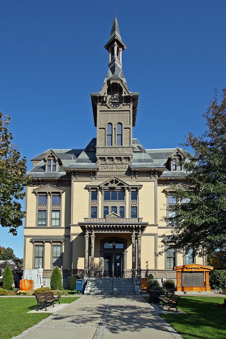
“Saugus Town Hall is a historic town hall in Saugus, Massachusetts. It was built in 1875 and added to the National Register of Historic Places in 1985.”
Wikipedia article Saugus Town Hall, CC BY-SA 4.0.
one of 350 National Register listings in Essex County · listed in 1985 · category: Building · one of 2 National Historic Landmarks in Essex County.
National Register reference number.85001332- the number the National Park Service assigned this property when it was listed, and the key its nomination file is catalogued under at the National Archives.
The ground it stands on
17,750 words
The chapter on Saugus Town in History of Saugus, Massachusetts, published 1916 names Saugus. This is what it says, exactly as the scans read.
To all who live within the borders of the ancient township of Lj^nn, the history of each part of that township has an abiding interest. The little settlement at Saugus, which later became an independent town, is one of the oldest in Massachusetts. As the scene of the first attempt to develop an iron industry in the United States, as the home of many families which have given distinguished men both to the State and the Nation, Saugus has a peculiar claim upon our attention. There is much to be learned from the history of the town as there is from the history of all the early towns of New England.
Hence we, of Saugus, especially interested, as we are, at this time, on the occasion of this our Centennial celebration, must needs be careful of what we incorporate in a history of the town,' for histories and historical references, sometimes may be like statues, monuments, tablets and markers, which, our own Senator Lodge has so well said, "can justify their existence on only, two gi'ounds - the nature of the subject they commemorate or as works of art." He opined that "we should permit none of them to be erected to deeds or to men who do not deserve them and who will not themselves be monumental in history and before the eyes of posterity, saying that when the subject is unworthy, then the monument or tablet, as was said of Sir John Vanburgh's palaces, is- simply a heavy load to the patient earth and an offense to the eyes of succeeding generations."
Regional context, not property-specific
evidence. The
federal wildfire occurrence database
lists 111 fires within 5 miles of Saugus Town Hall between
2003 and 2020, burning about 230 acres in total. 1 started naturally. 12 were recorded as arson.
Distance is straight-line from the map coordinates, so a fire counted
here may appear on a neighbouring settlement's page as well.
Reported cause
Fires
Recreation and ceremony
31
Debris and open burning
19
Missing data/not specified/undetermined
18
Smoking
16
Arson/incendiarism
12
Misuse of fire by a minor
5
Equipment and vehicle use
5
Fireworks
3
Power generation/transmission/distribution
1
Natural
1
The most recent of
them, most recent first, with the day each was reported and the service
that recorded it.
Regional context, not property-specific
evidence. Museums hold 12,324 specimens
collected within 10 miles of Saugus Town Hall between 1800 and
1975: 5,671 Plantae, 3,402 Animalia, 1,598 Fungi, 1,044 Chromista, 330 Bacteria, 252 Unrecorded, 27 Protozoa. 12 distinct Species records are shown.
Collected by ?, A B. Proper, A. A. Eaton and others. Each is a
physical object with a catalogue
number, and each entry opens the museum's record. This is what was
collected and kept, not a survey of what lives here - nothing can be
concluded from a species being absent.
Regional context, not property-specific
evidence. The federal mineral resources record lists
14 workings within 5 miles of Saugus Town Hall: 4 plants, 4 producers, 3 past producers, 2 unknowns.
8 still produce. What was taken out: Stone, Crushed/Broken, Silica, Sand and Gravel, Construction, Iron. Distance is straight-line from the
map coordinates, so a quarry counted here may appear on a neighbouring
settlement's page as well.
Regional context, not property-specific
evidence. The National Weather Service names
Saugus, the town this property stands in, in 14 storm reports between 2000 and 2021: 8 thunderstorm wind, 3 flash flood, 3 flood.
No death or injury is recorded in these reports. Each account below is quoted exactly as the forecast office
filed it, from the NOAA Storm Events Database, and each date
opens the federal record of that event.
In Lynn at 530 AM EST, Boston Street was flooded and impassable at Stetson Street. A car was trapped in flood waters at the intersection of Boston and Bridge Streets. At 536 AM EST, a car was trapped in flood waters at Lynn Commons; people in the car needed to be rescued. At 542 AM EST multiple cars were trapped in flood waters at the intersection of Boston Street and Cottage Street; the road was closed. Also multiple cars were trapped in flood waters at Washington and Johnson Streets. At 550 AM EST, Western Avenue, Liberty Street, and North Common Street were closed due to flooding. At 555 AM EST Alley Street was flooded and impassable. At 558 AM EST, a car was trapped in flooding on Commercial Street at Fenwick Street. At 649 AM EST, multiple cars were trapped in flood waters on Monroe, New Park, and Federal Streets as well as Western Avenue. At 8 AM EST, Ainsworth Place at Boston Road experienced flooding into buildings. An amateur radio operator in Lynn reported a storm total of 3.79 inches of rain.
At 10:08 AM EST, a microburst downed trees in Saugus along a one-mile path from the western side of Riverside Cemetery to Ballard Street. This path is roughly parallel to Winter Street. The maximum width of this microburst was approximately 250 yards. Several trees were reported down in Riverside Cemetery. Several trees were down on Riverside Park and Victoria Street. Several trees were down on Riverside Court. A tree and wires were down on Ballard Street.
No historic map-sheet match is published
for this property yet. That does not mean no map exists. This record needs
a coordinate-quality review before it can be joined to a sheet boundary.
Browse the county's mapped places while that work is
pending.
From the nomination file
3,215 words on record
When this property was proposed for the
National Register, someone wrote the case for it: what the building is,
and why it matters. That document is a federal record in the public domain.
It is quoted below word for word, never summarised. The text was read off the scanned case file by machine, so the
occasional stray character is the recogniser's and the 1970s
typewriter's.
Description of the property
Saugus Town Hall is an impressive and locally important example of High Victorian style architecture, Builtin 1875, the 2½storystructure withaipartially.excavated,: coursed granite basement is faced with flush wooden board and capped with a steeply pitched compound gable roof in an H configuration. The building's picturesque massing is further enhanced by two tent roof cupolas with finials; one prominently located at the front, and one placed at the rear. The roof is sheathed with banded decorative green and grey slate tiles. The cornice is bracketed and a wealth of Victorian ornamentation adorns the facades. Elongated windows on the first story have bracketed hoodmoldings and panelled lintels.
Most second story windows are sur- mounted by decoratively incised, bracketed wood pedimented hoodmolds, The central banded multiple window arrangement on the second level of the front (west) facade has a bracketed pedimented hoodmold with a gable fan and much incised and applied detailing on surrounding window elements. Attic windows include two dormered windows with gable trim and two small triangular windows on the front facade of the building. A wooden water table and panelled coursing separate the basement and first level, while flushboard coursing divides the first from the second level.
Three main entrances, one on the front (west) and two on the side (north and south) facades, are defined by granite stairs with scalloped foot rails and elaborate columned porches with bracketing and modillions. The building is oriented at a northeast angle facing a town square. Located on. the Town Hall grounds are several memorials: World War I, Vietnam, and a time capsule. - The building has a remarkable degree of integrity. All exterior work, with the exception of plugs for blown-in insulation and aluminum siding and window alterations . at the. rear, appears original.
(in one paragraph) The Saugus Town Hall, located in Saugus Center, attains significance with respect to two NRHP criterion - A and C. The Town Hall, as an important civic building and as a centrally located structure, directly relates to the development of the Saugus conmunity; while, as an impressive and important example of the High Victorian Style designed by regionally noteworthy architectural firm Lord & Fuller, the building achieves architectural distinction. The Town of Saugus was originally divided into three sections - Saugus Center, East Saugus, and Cliftondale.
While the East Saugus and Cliftondale sections of the town expanded through shoe manufacturing and tobacco-growing respectively, Saugus Center developed through the production of both shoes and woolen goods, as well as other manufacturing enterprises including a hair factory which processed animal hair for use as an additive for plaster and for weaving into textiles. In addition, transportation fostered the commercial and civic development of the Center. At mid-19th century the Saugus Branch of the Boston and Maine Railroad had extended from Malden, the Saugus Station was located on Central Street three blocks from Central Square, the heart of Saugus Center. Central Square was the major intersection of routes north from Boston to Salem and it connected with the New- bury Turpike.
All these factors produced great local growth. The town of Saugus erected its first Town Hall on Main Street (near the square) in 1837. The Greek Revival style structure, now home to a civic group, was later moved to Taylor St. It was built to serve a community of 750, which by the last quarter of the 19th century had grown to more than 2,000. A new town hall was built in 1875 to serve" -..the needs of a progressive and growing municipality".
Quoted from the National Register nomination
for reference 85001332, 19 pages, held by the National Archives in Record
Group 79. See the
catalogue record.
Listed places nearby
6 within 8 miles
Other National Register properties close
enough to walk or drive between, ordered by distance from this one. Both
positions come from the same geocoding pass that matched these properties
to their map sheets.
Listing record. National Park Service National Register of Historic Places, listed-properties dataset, current to 2026-05-22.
Map join. Address geocoded through the United States Census geocoder, then tested against the published boundary of every sheet in the USGS Historical Topographic Map Collection.
How this page is made. Listing fields come from federal records; map-sheet coverage is a labelled coordinate-to-boundary calculation, not a source-field claim.
Wildfire. Short, Karen C. 2022. Spatial wildfire occurrence data for the United States, 1992-2020 [FPA_FOD_20221014]. 6th Edition. Fort Collins, CO: Forest Service Research Data Archive. https://doi.org/10.2737/RDS-2013-0009.6 Collected with United States Government funding and usable without additional permissions or fees.
Specimens. Global Biodiversity Information Facility (GBIF), https://www.gbif.org/. Only records licensed CC0 or CC BY are used. Records licensed CC BY-NC are excluded because this site carries advertising. Images are checked individually and any whose licence is non-commercial, no-derivatives or unreadable is refused.
Mines and quarries. USGS Mineral Resources Data System (MRDS) https://mrdata.usgs.gov/mrds/ A work of the United States government, no copyright under 17 U.S.C. 105.
Storms. NOAA National Centers for Environmental Information, Storm Events Database https://www.ncei.noaa.gov/stormevents/ A work of the United States government, no copyright under 17 U.S.C. 105. Narratives are quoted verbatim from the National Weather Service report and are not edited or summarised.
 Block
Block