Listed on the National Register of Historic Places in
1985. A historic map-sheet match is not published yet. The record needs a coordinate-quality review before it can be joined to a sheet boundary.
From the record
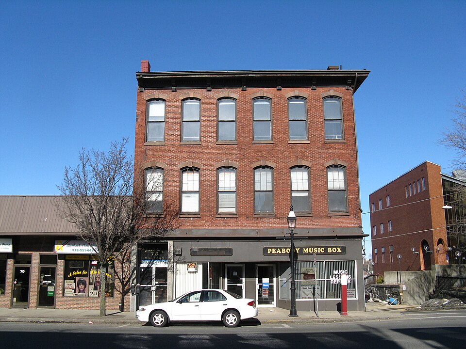
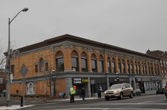
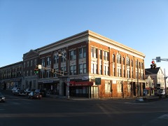
“The Sutton Block is a historic commercial building in Peabody, Massachusetts. Built in 1859, this three story brick building is the only Italianate commercial building in Peabody.”
Wikipedia article Sutton Block, CC BY-SA 4.0.
one of 350 National Register listings in Essex County · listed in 1985 · category: Building · one of 2 National Historic Landmarks in Essex County.
National Register reference number.85002012- the number the National Park Service assigned this property when it was listed, and the key its nomination file is catalogued under at the National Archives.
Mattresses and Feathers Renovated. Goods Called For and Returned Promptly. No. 15 Walnut Street, Peabody, Mass. - Cleanliness not only is essential to health, but it also preserves and renders more endurable every kin i of fabric and cloth. This fact is equally true whether applied to garments or the carpets, bedding and similar household goods. Few people realize how much longer these materials could be made to last if cleaned more regularly and carefully. The Peabody Laundry and Steam Carpet Cleaning Works has now for nine years demonstrated its ability to handle every class ol work in these lines in the most modern and satisfactory style. The laundry business was established in 1883, and the entire enterprise has been under Mr. Charles A. Sanger's efficient management since 1884. Large and thoroughly equipped premises are occupied. A 12 horse-power engine and 30 horsepower boiler furnishes steam power, and the machinery throughout is of the latest and best type. The steam carpet beating department occupies a separate building. The^laundry work in all lines is guaranteed to be on a par with the best anywhere in this country, while the prompt service and low prices are points worth noting carefully. Of late years the services of the Steam Carpet Beating Works have been increasing steadily in popularity. The prices are as low as those afforded by any other kind of service, while in efficiency and thorough care the advantages of the Steam Beating Works are greatly superior to all others. They call for and deliver goods on request in Peabody, Salem and Danvers, taking in charge not only ingrains, tapestries, brussels, axminsters, wiltons, etc., but also fine rugs and laces, mat^tresses, feathers, and any household paraphernalia needing careful and thorough cleaning. An examination of the facilities and rates of these well conducted works will convince anyone of the superior advantages offered by them.
Flowers possess a perennial cliarm for all cultivated people, and it is one of the triumphs of modern skill that we are now enabled to obtain them in abundance at any season of the year. Among the floral establishments of Peabody and vicinity that of Mr. J. M. Ward has long held a prominent and esteemed position. The business was established by Mr. Ward in 1875 and has made steady progress under his management from the start. Four large green-houses are now utilized for the cultivation of the varied floral stock of this house, the space of 4,000 square feet being devoted entirely to this purpose. Every variety of favorite flowers, including choice roses, carnations, lilies, pansies, etc., etc., are kept constantly on hand. Cut flowers and bouquets are sold at unexcelled prices. Special attention is given to funeral and memorial designs. A fine variety of palms, ferns, selaginellas and all kinds of potted plants are ready for use at any time. The immense variety and beauty of Mr. Ward's siock. as well as his uniformly liberal prices, make it a matter both of pleasure and economy to make use of his large facilities in these lines. Mr. Ward is a native of England and one of Peabody's most substantial and esteemed business men.
Regional context, not property-specific
evidence. The
federal wildfire occurrence database
lists 83 fires within 5 miles of Sutton Block between
2003 and 2020, burning about 279 acres in total. 1 started naturally. 4 were recorded as arson.
Distance is straight-line from the map coordinates, so a fire counted
here may appear on a neighbouring settlement's page as well.
Reported cause
Fires
Recreation and ceremony
28
Smoking
13
Equipment and vehicle use
10
Misuse of fire by a minor
6
Missing data/not specified/undetermined
6
Debris and open burning
6
Fireworks
5
Arson/incendiarism
4
Power generation/transmission/distribution
2
Natural
1
Railroad operations and maintenance
1
Other causes
1
The most recent of
them, most recent first, with the day each was reported and the service
that recorded it.
Regional context, not property-specific
evidence. Museums hold 9,916 specimens
collected within 10 miles of Sutton Block between 1800 and
1975: 4,114 Plantae, 3,129 Animalia, 1,074 Fungi, 922 Chromista, 439 Unrecorded, 189 Bacteria, 49 Protozoa. 12 distinct Species records are shown.
Collected by A B. Proper, A H HIGGINSON, A. A. Eaton and others. Each is a
physical object with a catalogue
number, and each entry opens the museum's record. This is what was
collected and kept, not a survey of what lives here - nothing can be
concluded from a species being absent.
Regional context, not property-specific
evidence. The federal mineral resources record lists
14 workings within 5 miles of Sutton Block: 5 plants, 4 past producers, 3 producers, 1 unknown.
8 still produce. What was taken out: Stone, Crushed/Broken, Sand and Gravel, Construction, Zirconium, Iron. Distance is straight-line from the
map coordinates, so a quarry counted here may appear on a neighbouring
settlement's page as well.
Regional context, not property-specific
evidence. The National Weather Service names
Peabody, the town this property stands in, in 47 storm reports between 1993 and 2025: 22 thunderstorm wind, 11 hail, 6 flood, 4 lightning.
The reports record 1 injury. Each account below is quoted exactly as the forecast office
filed it, from the NOAA Storm Events Database, and each date
opens the federal record of that event.
In Lynn, Alley and Commercial streets experienced significant flooding. A car was stranded on Chatham Street. In Peabody, a car was stranded near Foster and Spring Streets. Shaws Lane and Oak Streets were flooded.
Several cars were stranded due to flooding on Canal Street in Salem, as well as at Salem State College. Urban flooding was more severe in Peabody, where Fountain Street was flooded and voluntary evacuations took place. Several streets near the center of Peabody were also closed due to flooding.
At 10:33 AM EST, Quail Road in South Peabody was closed due to flooding. At 10:52 AM EST, Lynnfield Street was closed due to flooding. At 11:07 AM EST, a car was reported trapped in floodwaters on Lynnfield Street. At 11:14 AM a car was trapped in floodwaters on Lake Street near U.S. Route 1; Lake Street was reported closed soon after. At 11:33 AM EST, a house on Batchelder Avenue was reported to have 4 feet of water in the basement.
Trees and wires were downed on Winona and Corey Drives, and Lake, Forest, Baldwin, Wheatland, and Lowell Streets. So many trees were downed on Lowell Street that the street was closed.
Trees and wires were downed on several streets in Lynn and Peabody, including on Greenwood Road in Peabody and on Herschel Street in Lynn. One of the trees on Herschel Street landed on a car.
In Peabody, a tree was down on a truck on Norfolk Avenue. A tree was down on power lines at both Lynnfield Street and Columbia Blvd. A tree was down on Bartlett Street.
Two trees down in Salem Willows Park. Numerous dime-size hail stones fell at approximately 1845 EST in West Peabody with one or two stones just under the size of a quarter as measured by the son of a NWS meteorologist. Rainfall in Peabody was 1.68 inches.
No historic map-sheet match is published
for this property yet. That does not mean no map exists. This record needs
a coordinate-quality review before it can be joined to a sheet boundary.
Browse the county's mapped places while that work is
pending.
From the nomination file
2,718 words on record
When this property was proposed for the
National Register, someone wrote the case for it: what the building is,
and why it matters. That document is a federal record in the public domain.
It is quoted below word for word, never summarised. The text was read off the scanned case file by machine, so the
occasional stray character is the recogniser's and the 1970s
typewriter's.
Description of the property
The Sutton Block is located at 76-78 Main Street on the corner of Main and Wallis Streets. The building is a three-story Italianate commercial block. Trapezoidal in plan, the Sutton Block fills its entire lot, with its south elevation on Main Street and its north and east elevations on Wallis Street. The building's west elevation is a party wall, now partly visible as a result of the demolition of the adjacent building. The building is constructed of red brick laid in stretcher bond and the facades are trimmed with brownstone and granite. The building is crowned by an elaborate wood cornice, but the original hip roof has been removed and replaced with a flat roof.
At the ground level of the Main Street or south facade, an entrance at the west corner of the facade retains its original rock-faced granite piers. A mid-twentieth century storefront, constructed of metal panels and aluminum, consists of two recessed central doorways flanked by glass display windows. At the second- and third-story levels, the Main Street facade is six bays wide with evenly-spaced segmentally-arched window openings. The windows throughout the building have 6/1 sash framed by brownstone sills and segmentally- arched lintels with central keystones. On the first story of the east elevation, a portion of the Main Street storefront wraps around the southern corner of the facade, while beyondthis are three full-sized segmentally-arched windows.
There is a single half-window at basement level. Above the first story, the east elevation is distinguished by a slightly more elaborate fenestration pattern. The four second- and third-story segmentally-arched windows are recessed within two-story brick segmental arched piers.
(in one paragraph) unknown The Sutton Block retains integrity of location, design, setting, materials, workmanship, feeling and association. Erected in 1859, the building has historical associations with Ebenezer Sutton, a leading nineteenth-century industrialist in the woolen industry. ng nthe eemeh-centur Built by Sutton along a residential section of Main Street, this commercialblock foreshadowed the later nineteenth-century expansion of Peabody's commercial center. The Sutton Block is architecturally significant as Peabody's only Italianate commercial block. Thus, the Sutton Block meets criteria A and C for listing on the National Register of Historic Places, with significance at the local level.
Born in 1803, Ebenezer Sutton was the son of William Sutton, a Peabody wool manufacturer who served as a State Representative and the first president of the South Danvers Bank. When William Sutton died in 1832, his woolen factories in South Danvers (now Peabody) and in North Andover were inherited by Ebenezer Sutton and his brother General William Sutton. Four years later, Ebenezer bought his brother's interest in the NorthAndover woolen mills. Sutton appears to have made an astute decision, and to have operated the mills successfully, for in 1851 he was listed in Rich Men of Massachusetts with a fortune worth $500,000. Besides his business interests, Sutton was a Colonel in the Essex Regiment and a director of the Eastern Railroad. Sutton died in 1864.
-Sutton's influence in Peabody continued after his death, for in 1866 his wife Eliza Sutton donated the Eben Dale Sutton Reference Library, located within the Peabody Institute, as a memorial to her son. In the mid-nineteenth century, the Main Street of South Danvers was almost completely residential. Ebenezer Sutton himself had built his residence at 55-59 Main Street in 1854.
Quoted from the National Register nomination
for reference 85002012, 12 pages, held by the National Archives in Record
Group 79. See the
catalogue record.
Listed places nearby
6 within 8 miles
Other National Register properties close
enough to walk or drive between, ordered by distance from this one. Both
positions come from the same geocoding pass that matched these properties
to their map sheets.
Listing record. National Park Service National Register of Historic Places, listed-properties dataset, current to 2026-05-22.
Map join. Address geocoded through the United States Census geocoder, then tested against the published boundary of every sheet in the USGS Historical Topographic Map Collection.
How this page is made. Listing fields come from federal records; map-sheet coverage is a labelled coordinate-to-boundary calculation, not a source-field claim.
Wildfire. Short, Karen C. 2022. Spatial wildfire occurrence data for the United States, 1992-2020 [FPA_FOD_20221014]. 6th Edition. Fort Collins, CO: Forest Service Research Data Archive. https://doi.org/10.2737/RDS-2013-0009.6 Collected with United States Government funding and usable without additional permissions or fees.
Specimens. Global Biodiversity Information Facility (GBIF), https://www.gbif.org/. Only records licensed CC0 or CC BY are used. Records licensed CC BY-NC are excluded because this site carries advertising. Images are checked individually and any whose licence is non-commercial, no-derivatives or unreadable is refused.
Mines and quarries. USGS Mineral Resources Data System (MRDS) https://mrdata.usgs.gov/mrds/ A work of the United States government, no copyright under 17 U.S.C. 105.
Storms. NOAA National Centers for Environmental Information, Storm Events Database https://www.ncei.noaa.gov/stormevents/ A work of the United States government, no copyright under 17 U.S.C. 105. Narratives are quoted verbatim from the National Weather Service report and are not edited or summarised.
 Block
Block