Listed on the National Register of Historic Places in
1986. A historic map-sheet match is not published yet. The record needs a coordinate-quality review before it can be joined to a sheet boundary.
From the record
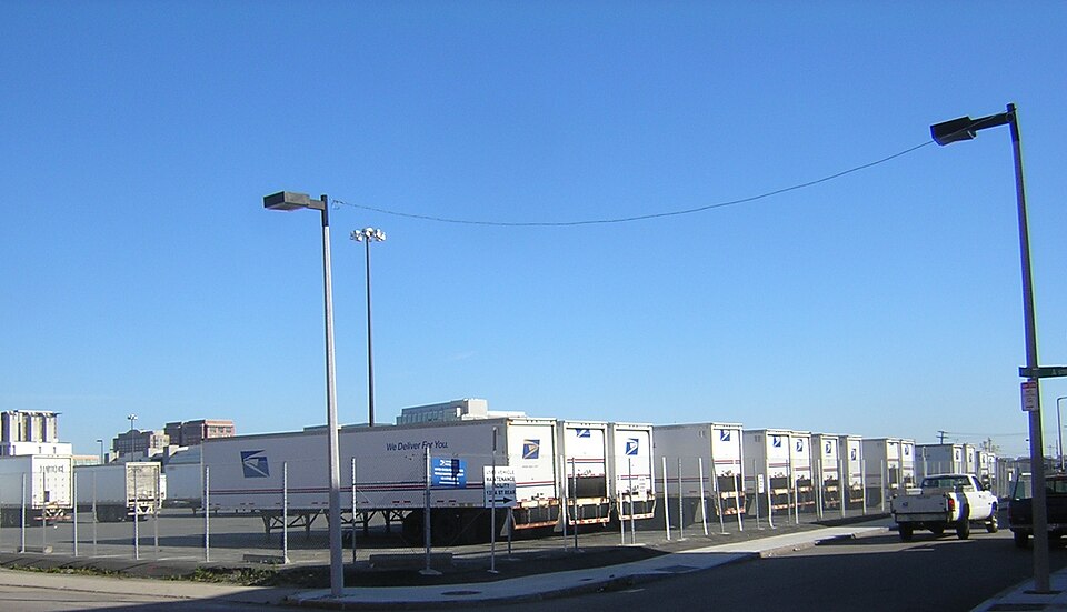
“The US Post Office Garage was a historic vehicle maintenance facility at 135 A Street in the South Boston neighborhood of Boston, Massachusetts. The two story building was designed in the International Style by Gilbert Stanley Underwood and completed in 1941 by a construction team headed by John Volpe.”
Wikipedia article United States Post Office Garage, CC BY-SA 4.0.
one of 206 National Register listings in Suffolk County · listed in 1986 · category: Building · one of 5 National Historic Landmarks in Suffolk County.
National Register reference number.86001378- the number the National Park Service assigned this property when it was listed, and the key its nomination file is catalogued under at the National Archives.
What happened here
An account from the chapter on Boston city, The inset identifies its exact
source book and publication year.
IN giving some notices of manners and social life during this period, I shall speak first of usages which were characteristic of the close of the last century: most of them continued without essential modification until our city charter swept away the old landmarks, and Boston felt the im¬ pulses which mark a new epoch in her history.
Boston has grown in area not only by reclaiming land from the sea, but by absorbing neighboring territory, - first, by the annexation of parts of the domain of adjoining municipalities ; and latterly, by taking the whole, - extinguishing the separate municipal existence of the cities and towns absorbed. In this way South Boston (or Dorchester Neck as it was then called), Washington Village, Roxbury, Dorchester, Charlestown, Brighton,
The first acquisition of territory beyond the original limits of the town was South Boston, known at the beginning of the present century as Dor¬ chester Neck. Although separated from Boston by a channel only a few hundred yards wide, there was no communication between the two penin¬ sulas except by means of occasional row-boats, which could ply only at high tide; but as there were only ten families then residing on the Neck,1 by one of his wives, and the share of each was ing eighteen inches on Beacon Street, and eighty one-two hundred and fifty-second part of the feet deep.
Regional context, not property-specific
evidence. The
federal wildfire occurrence database
lists 46 fires within 5 miles of US Post Office Garage between
2015 and 2020, burning about 31 acres in total. None started naturally. 2 were recorded as arson.
Distance is straight-line from the map coordinates, so a fire counted
here may appear on a neighbouring settlement's page as well.
Reported cause
Fires
Recreation and ceremony
17
Missing data/not specified/undetermined
13
Smoking
8
Debris and open burning
5
Arson/incendiarism
2
Equipment and vehicle use
1
The most recent of
them, most recent first, with the day each was reported and the service
that recorded it.
Regional context, not property-specific
evidence. Museums hold 18,535 specimens
collected within 10 miles of US Post Office Garage between 1810 and
1975: 8,481 Plantae, 4,453 Fungi, 3,768 Animalia, 1,278 Chromista, 229 Bacteria, 212 Protozoa, 114 Unrecorded. 12 distinct Species records are shown.
Collected by (MARSDEN, H W), ?, A B Seymour and others. Each is a
physical object with a catalogue
number, and each entry opens the museum's record. This is what was
collected and kept, not a survey of what lives here - nothing can be
concluded from a species being absent.
Regional context, not property-specific
evidence. The federal mineral resources record lists
10 workings within 5 miles of US Post Office Garage: 8 plants, 2 past producers.
8 still produce. What was taken out: Iron, Lead, Gypsum-Anhydrite, Sand and Gravel, Construction. Distance is straight-line from the
map coordinates, so a quarry counted here may appear on a neighbouring
settlement's page as well.
Regional context, not property-specific
evidence. The National Weather Service names
South Boston, the town this property stands in, in 8 storm reports between 2004 and 2022: 5 thunderstorm wind, 2 lightning, 1 hail.
The reports record 1 death and 1 injury. Each account below is quoted exactly as the forecast office
filed it, from the NOAA Storm Events Database, and each date
opens the federal record of that event.
A 50 year old man was struck by lightning while walking in an area known as the Sugar Bowl in South Boston. Lightning struck him in the head, passing through his back and exiting his feet. He collapsed in cardiac arrest and was revived and hospitalized for several days before dying from his injuries.
No historic map-sheet match is published
for this property yet. That does not mean no map exists. This record needs
a coordinate-quality review before it can be joined to a sheet boundary.
Browse the county's mapped places while that work is
pending.
From the nomination file
2,650 words on record
When this property was proposed for the
National Register, someone wrote the case for it: what the building is,
and why it matters. That document is a federal record in the public domain.
It is quoted below word for word, never summarised. The text was read off the scanned case file by machine, so the
occasional stray character is the recogniser's and the 1970s
typewriter's.
Description of the property
_PHYSICAL APPEARANCE_ This two-story building is trapezoidal in plan, almost totally occupying the site. The exterior walls are poured concrete on a pile foundation, scored to suggest panelization, and have streamlined curved corners. It has a steel roof frame and gypsum and concrete roof decks. A base is suggested by slightly projecting the concrete foundation around the building. Some minor deterioration and discoloration is visible, but considering the wear and tear the building must endure, it is in very good condition. Previously stark concrete in color, the building was painted bright yellow in 1983, which can withstand abuse better than a paler color.
The functional nature of the building is expressed on the exterior by window placement and the building is divided into two areas: maintenance and operations. The maintenance area for the storage and repair of vehicles is distinguished by large expanses of steel sash, wire glass windows with operable awning sections and metal louvers. The operations area for the running of the building, dispatch, and inventory control is juxtaposed by utilizing smaller areas of windows. Where the plan places the operations and smaller maintenance areas along the exterior wall, a playful composition of windows is established. A small mezzaine level in the rear adds another dialog by its need of light at an in-between level.
Three features of the garage's program add another layer of intrigue to the total composition of the building. First, the vehicle entry (located at the southeast corner on "A" Street) is defined by sweeping curves indicating the flow of traffic in and out. Gilded aluminum letters above on a thin awning are the only embellishment to the exterior. Within the curved walls are small security windows for the dispatcher and general foreman.
/ARCHITECT Gilbert Stnaley Underwood, Con. Architect STATEMENT OF SIGNIFICANCE Grande å Volpe, Inc. - Contractor The Post Office Vehicle Maintenance Facility is located in an industrial district of South Boston on "A" Street between West First Street and Sobin Park. Manufacturing and warehouse structures, many constructed before 1900 and built of brick, predominate in this area. This building is an important landmark within its urban context by virtue of its striking design and bright yellow coloration. Although less than fifty (50) years old, this building is eligible to the National Register of Historic Places as a rare Boston-area example of the International style.
It is reminiscent of Pre-World War Il structure in Western Europe, the birth place of this style - The International style emerged during the 1920's and 1930's in Germany, Holland, France, etc. Its rallying cry was "ornament is crime." Proponents of this style viewed buildings as space enclosing envelopes. This view fits in well with the functional needs of man organizations-such as the U.S. Post Office-for interchangeable work areas. The Vehicle Maintenance Facility's scored concrete exterior simulating individual panels, and the large glass and steel sash areas are consistent with the style's design tenets based on factory fabricated components. Its emphasis on function- alism, stark simplicity, open planning and usage of mundance components (i.e.
the elevator and ramp) as visible design elements are the hallmarks of the Federal Government's move away from classical tradition to one heralding the modern machine age. Indeed, the International style presented a challenge to Ecole der Beaux Arts trained architects steeped in the Classical stylewhich had been revived during the 1890's and 1900's. This building represents the work of West Coast modernist Gilbert Stanley Underwood (no citation in Withey's Dictionary of AmericanArchitects).
Quoted from the National Register nomination
for reference 86001378, 17 pages, held by the National Archives in Record
Group 79. See the
catalogue record.
Listed places nearby
6 within 8 miles
Other National Register properties close
enough to walk or drive between, ordered by distance from this one. Both
positions come from the same geocoding pass that matched these properties
to their map sheets.
Listing record. National Park Service National Register of Historic Places, listed-properties dataset, current to 2026-05-22.
Map join. Address geocoded through the United States Census geocoder, then tested against the published boundary of every sheet in the USGS Historical Topographic Map Collection.
How this page is made. Listing fields come from federal records; map-sheet coverage is a labelled coordinate-to-boundary calculation, not a source-field claim.
Wildfire. Short, Karen C. 2022. Spatial wildfire occurrence data for the United States, 1992-2020 [FPA_FOD_20221014]. 6th Edition. Fort Collins, CO: Forest Service Research Data Archive. https://doi.org/10.2737/RDS-2013-0009.6 Collected with United States Government funding and usable without additional permissions or fees.
Specimens. Global Biodiversity Information Facility (GBIF), https://www.gbif.org/. Only records licensed CC0 or CC BY are used. Records licensed CC BY-NC are excluded because this site carries advertising. Images are checked individually and any whose licence is non-commercial, no-derivatives or unreadable is refused.
Mines and quarries. USGS Mineral Resources Data System (MRDS) https://mrdata.usgs.gov/mrds/ A work of the United States government, no copyright under 17 U.S.C. 105.
Storms. NOAA National Centers for Environmental Information, Storm Events Database https://www.ncei.noaa.gov/stormevents/ A work of the United States government, no copyright under 17 U.S.C. 105. Narratives are quoted verbatim from the National Weather Service report and are not edited or summarised.
 Block
Block