Listed on the National Register of Historic Places in
1986. A historic map-sheet match is not published yet. The record needs a coordinate-quality review before it can be joined to a sheet boundary.
From the record
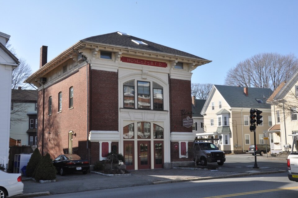
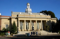
“Hose House No. 2 is a historic firestation in Beverly, Massachusetts. It now houses a wireless telecommunication systems company.”
Wikipedia article Hose House No. 2 (Beverly, Massachusetts), CC BY-SA 4.0.
one of 350 National Register listings in Essex County · listed in 1986 · category: Building · one of 2 National Historic Landmarks in Essex County.
National Register reference number.86001461- the number the National Park Service assigned this property when it was listed, and the key its nomination file is catalogued under at the National Archives.
Fires near this property
58 since 2006
Regional context, not property-specific
evidence. The
federal wildfire occurrence database
lists 58 fires within 5 miles of Hose House No. 2 between
2006 and 2020, burning about 228 acres in total. 1 started naturally. 1 was recorded as arson.
Distance is straight-line from the map coordinates, so a fire counted
here may appear on a neighbouring settlement's page as well.
Reported cause
Fires
Recreation and ceremony
17
Smoking
10
Equipment and vehicle use
9
Debris and open burning
7
Missing data/not specified/undetermined
5
Misuse of fire by a minor
3
Fireworks
2
Power generation/transmission/distribution
2
Natural
1
Railroad operations and maintenance
1
Arson/incendiarism
1
The most recent of
them, most recent first, with the day each was reported and the service
that recorded it.
Regional context, not property-specific
evidence. Museums hold 9,283 specimens
collected within 10 miles of Hose House No. 2 between 1800 and
1975: 3,795 Plantae, 2,481 Animalia, 1,408 Fungi, 931 Chromista, 465 Unrecorded, 138 Bacteria, 65 Protozoa. 12 distinct Species records are shown.
Collected by A B. Proper, A H HIGGINSON, A. A. Eaton and others. Each is a
physical object with a catalogue
number, and each entry opens the museum's record. This is what was
collected and kept, not a survey of what lives here - nothing can be
concluded from a species being absent.
Regional context, not property-specific
evidence. The federal mineral resources record lists
8 workings within 5 miles of Hose House No. 2: 5 plants, 1 unknown, 1 producer, 1 past producer.
6 still produce. What was taken out: Stone, Crushed/Broken, Zirconium, Thorium, Tungsten. Distance is straight-line from the
map coordinates, so a quarry counted here may appear on a neighbouring
settlement's page as well.
Regional context, not property-specific
evidence. The National Weather Service names
Beverly, the town this property stands in, in 15 storm reports between 1993 and 2020: 7 thunderstorm wind, 3 hail, 2 flood, 1 heavy rain.
No death or injury is recorded in these reports. Each account below is quoted exactly as the forecast office
filed it, from the NOAA Storm Events Database, and each date
opens the federal record of that event.
Local police reported numerous trees blown down. At the Beverly Airport, a wind gust to an estimated 70 to 75 mph occurred during a severe thunderstorm, flipping over several light aircraft and damaging a total of 14 aircraft. Five were damaged beyond repair.
The Federal Street railroad underpass and portions of Park Street flooded, resulting in several cars getting stuck in the floodwaters. At least eight inches of water flooded the Cummings Center, flooding all first floor businesses (about 200). The Department of Public Works garage flooded, damaging police cars and other city vehicles. Approximately 100 houses were affected by flooding.
Several trees downed. Lightning struck several homes. Damage by fire occurred to one house on Gregg Street after lightning hit a telephone cable entering the house.
No historic map-sheet match is published
for this property yet. That does not mean no map exists. This record needs
a coordinate-quality review before it can be joined to a sheet boundary.
Browse the county's mapped places while that work is
pending.
From the nomination file
3,034 words on record
When this property was proposed for the
National Register, someone wrote the case for it: what the building is,
and why it matters. That document is a federal record in the public domain.
It is quoted below word for word, never summarised. The text was read off the scanned case file by machine, so the
occasional stray character is the recogniser's and the 1970s
typewriter's.
Description of the property
Hose House #2 is located on the southwestern corner of Rantoul and School Streets in the southern section of Beverly, six blocks north of the harbor and the Fish Flake Hill Historic District (NR pending). Rantoul Street (Route lA) is a major north/south artery through the city. Built in 1905, the hose house is a smal1, 2 1/2-story red brick structure, rectangular in plan. The building rests on a granite foundation, and is enclosed by a low-pitched slate-sheathed pyramidal roof with copper flashing and gutters. With its classical ornamentation, pyramidal roofline, and boxlike plan, the hose house is reminiscent of the Second Renaissance Revival style.
The building occupies virtually all of its5,000-square-foot lot in this densely built section of Beverly, whose building stock consists primarily of turn-of-the-century three- deckers. It faces east and is fronted by a broad, brick-covered drive. There is a smal1 1awn on the building's southern side. Thirty feet wide by forty-five feet long, the station is three bays wide on its main (eastern) facade, dominated by a wide central door (now glass, originally wood). The central bay is enframed by an architrave with alternating voussoirs and divided sash transom. Directly above the doorway, a Palladian-style triple window on the second story is set beneath a segmental arch accented with a console, and rests on a continuous sill with dentils.
The central bay is flanked by two monumental brick pilasters articulated with classical entablature and bases. These rest on brick pedestals featuring wooden tablets (now blank). The broad overhanging roof with exposed rafters is supported by a placqued cornice and heavy, paired carved brackets. The cornice encircles the building. On the frieze above the central bay, an inscription reads "Hose - 2 - B. F. D.".
/Architect Kilham & Hopkins, Architects Statement of Significance (in one paragraph) Constructed in 1905, Hose House #2 retains integrity of location, design, setting, materials, feeling, workmanship, and association. The building was designed by the Boston architecture firm of Kilham and Hopkins, well known for their designs of schools and other public buildings in the first decades of the 20th century.The hose house is architecturally significant as a modest, well-preserved example of the Second Renaissance Revival style. Historically, the property is significant as a reflection of Beverly's sharp increase in both population and community services at the turn of the century. It thus fulfils Criteria A and C of the National Register of Historic Places on the local level.
Originally part of Salem, Beverly was first settled ca. 1627. Settlement spread north from the shore of the Danvers River along the road to Wenham (now Cabot Street) and along the waterfront, where a flourishing fishing economy was located by the mid 18th century. After the Revolution, the activity at Beverly Harbor became centered on shipbuilding, and the prominence of maritime industries and the prosperity that accompanied them continued well into the 19th century. In 1839, the Boston and Maine Railroad arrived in Beverly, crossing the river westof Cabot Street and running up the hill to a depot 1/2 mile north of the shore. With the railroad, industrial and commercial development turned north to the depot.
Beverly s economy diversified, with shoe manufacturing gradually replacing maritime-related enterprises as the city's economic focus. Between ca.: 1845 and 1865, streets platted in the new "downtown" area increased fivefold; Rantoul Street, a new north/south avenue leading from the waterfront, west of the railroad tracks, was established during this period.
Quoted from the National Register nomination
for reference 86001461, 14 pages, held by the National Archives in Record
Group 79. See the
catalogue record.
Listed places nearby
6 within 8 miles
Other National Register properties close
enough to walk or drive between, ordered by distance from this one. Both
positions come from the same geocoding pass that matched these properties
to their map sheets.
Listing record. National Park Service National Register of Historic Places, listed-properties dataset, current to 2026-05-22.
Map join. Address geocoded through the United States Census geocoder, then tested against the published boundary of every sheet in the USGS Historical Topographic Map Collection.
How this page is made. Listing fields come from federal records; map-sheet coverage is a labelled coordinate-to-boundary calculation, not a source-field claim.
Wildfire. Short, Karen C. 2022. Spatial wildfire occurrence data for the United States, 1992-2020 [FPA_FOD_20221014]. 6th Edition. Fort Collins, CO: Forest Service Research Data Archive. https://doi.org/10.2737/RDS-2013-0009.6 Collected with United States Government funding and usable without additional permissions or fees.
Specimens. Global Biodiversity Information Facility (GBIF), https://www.gbif.org/. Only records licensed CC0 or CC BY are used. Records licensed CC BY-NC are excluded because this site carries advertising. Images are checked individually and any whose licence is non-commercial, no-derivatives or unreadable is refused.
Mines and quarries. USGS Mineral Resources Data System (MRDS) https://mrdata.usgs.gov/mrds/ A work of the United States government, no copyright under 17 U.S.C. 105.
Storms. NOAA National Centers for Environmental Information, Storm Events Database https://www.ncei.noaa.gov/stormevents/ A work of the United States government, no copyright under 17 U.S.C. 105. Narratives are quoted verbatim from the National Weather Service report and are not edited or summarised.
 Block
Block